
Incident Publication
Lick Creek Fire Update for July 23 2021
Related Incident:
Publication Type: News
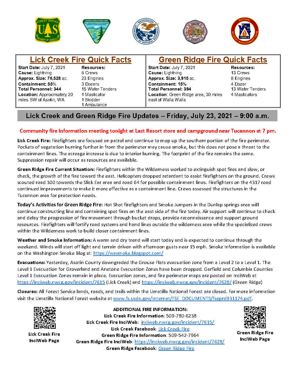
Community fire information meeting tonight at Last Resort store and campground near Tucannon at 7 pm.
Lick Creek Fire Update for July 24 2021
Related Incident:
Publication Type: News
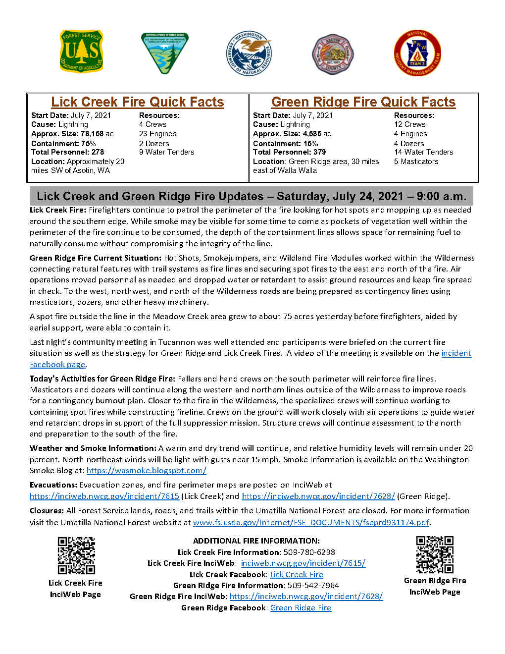
Lick Creek Fire: Firefighters continue to patrol the perimeter of the fire looking for hot spots and mopping up as needed around the southern edge. While smoke may be visible for some time to come as pockets of vegetation well within the perimeter of the fire continue to be consumed, the depth of the containment lines allows space for remaining fuel to naturally consume without compromising the integrity of the line.
Weather and Smoke Information: A warm and dry trend will continue, and relative humidity levels will remain under 20 percent. North northeast winds will be light with gusts near 15 mph. Smoke Information is available on the Washington Smoke Blog at: https://wasmoke.blogspot.com/
Evacuations: Evacuation zones, and fire perimeter maps are posted on InciWeb at https://inciweb.nwcg.gov/incident/7615 (Lick Creek) and https://inciweb.nwcg.gov/incident/7628/ (Green Ridge).
Closures: All Forest Service lands, roads, and trails within the Umatilla National Forest are closed. For more information visit the Umatilla National Forest website at www.fs.usda.gov/Internet/FSE_DOCUMENTS/fseprd931174.pdf.
Smoke Outlook for July 24 2021
Related Incident:
Publication Type: News
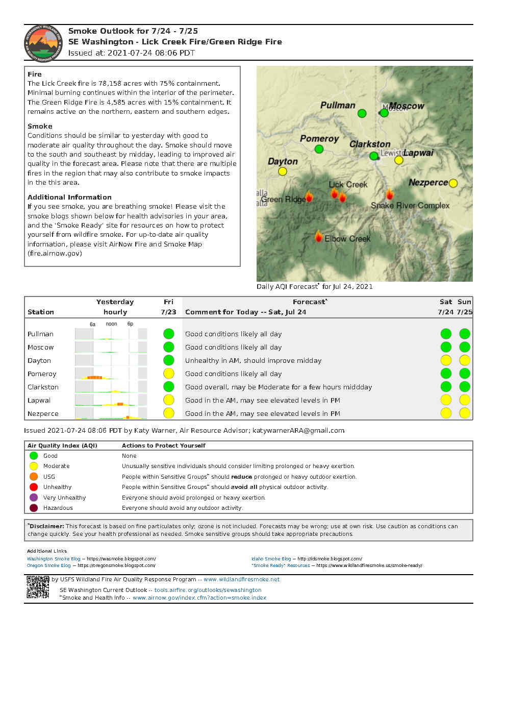
The Lick Creek fire is 78,158 acres with 75% containment. Minimal burning continues within the interior of the perimeter.
Conditions should be similar to yesterday with good to moderate air quality throughout the day.
Smoke should move to the south and southeast by midday, leading to improved air quality in the forecast area. Please note that there are multiple fires in the region that may also contribute to smoke impacts in the this area.
If you see smoke, you are breathing smoke! Please visit thesmoke blogs shown below for health advisories in your area, and the 'Smoke Ready' site for resources on how to protect yourself from wildfire smoke. For up-to-date air quality information, please visit AirNow Fire and Smoke Map(fire.airnow.gov)
Smoke Outlook for July 25 2021
Related Incident:
Publication Type: News
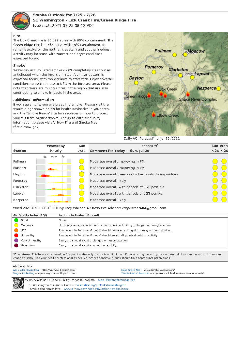
The Lick Creek fire is 80,392 acres with 90% containment. It remains active on the northern, eastern and southern edges. Activity may increase with warmer and dryer conditions expected today.
Yesterday accumulated smoke didn't completely clear out as anticipated when the inversion lifted. A similar pattern is expected today, with more smoke to start with. Expect overall conditions to be Moderate to USG in the forecast area. Please note that there are multiple fires in the region that are also contributing to smoke impacts in the area.
If you see smoke, you are breathing smoke! Please visit the smoke blogs shown below for health advisories in your area, and the 'Smoke Ready' site for resources on how to protect yourself from wildfire smoke. For up-to-date air quality information, please visit AirNow Fire and Smoke Map (fire.airnow.gov)
Lick Creek Fire Update for July 26
Related Incident:
Publication Type: News
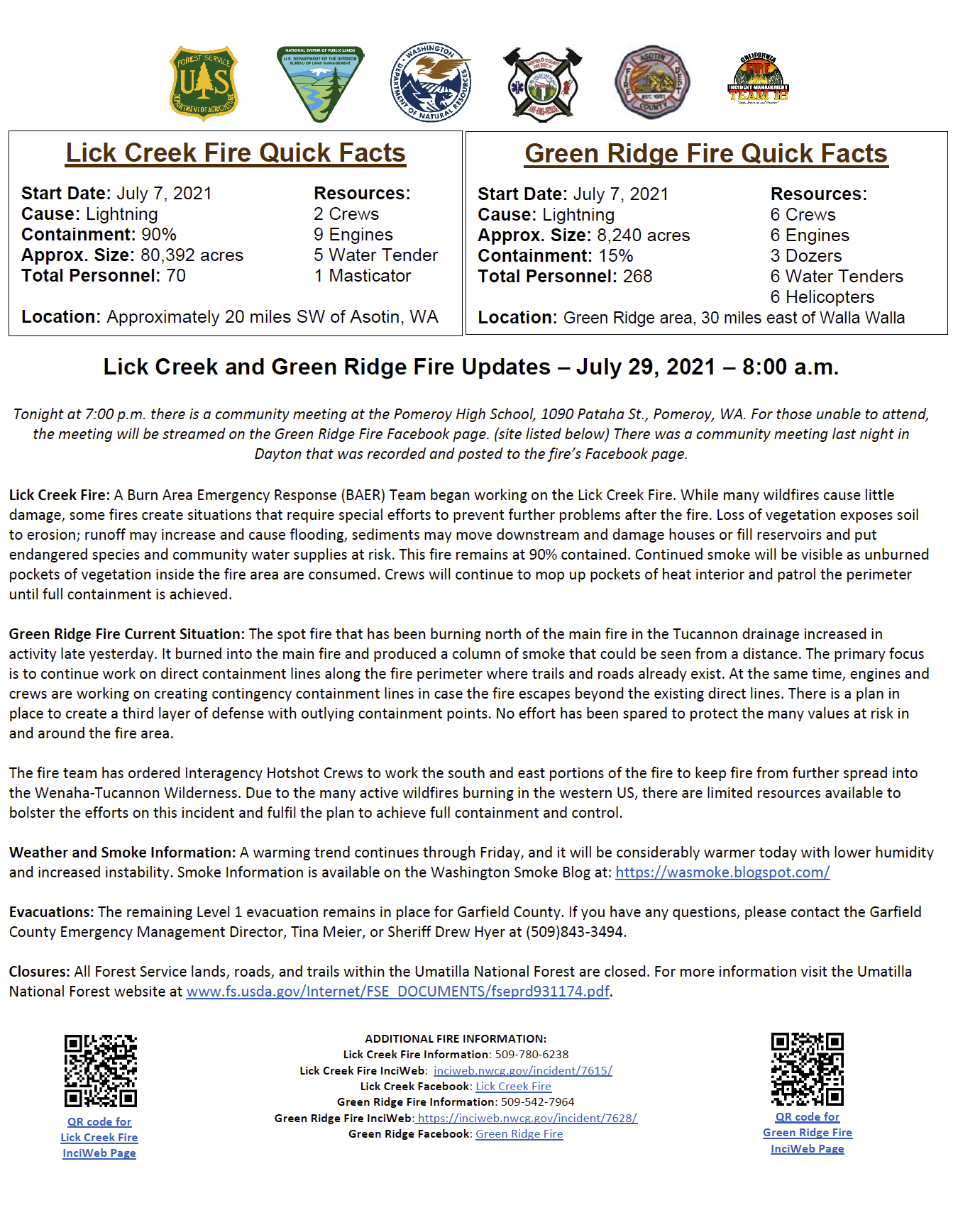
Lick Creek Fire Quick Facts
Start Date: July 7, 2021
Resources:
Cause: Lightning
2 Crews
Approx. Size: 80,392 ac.
9 Engines
Containment: 90%
2 Dozers
Total Personnel: 203
7 Water Tenders
Location: Approximately 20 miles SW of Asotin, WA
Lick Creek Fire: The Lick Creek Fire is 90% contained. Smoke will continue to be visible as unburned pockets of vegetation inside the fire area are consumed. A small spot fire approximately 100 feet from the southern perimeter was contained by crews that are monitoring and patrolling the fire.
Green Ridge Fire Current Situation: Preparation of roads on the north, west and south of the fire for burnout operations is ongoing. Handline from the 030 Road northwest to Panjab and north from Panjab to Meadow Creek has been completed. From Meadow Creek to the northwest, handline and hose lays are in place connecting to the 4022 road where mechanical line preparation has tied into the southern side of the Lick Creek Fire.
Today’s Activities for Green Ridge Fire: A wildland fire module will continue to work along the northern portion of the fire inside the Wilderness boundary. Crews will be finishing structure assessment and protection measures to the south near Godman Guard Station and to the north near Tucannon. Structure assessment and protection will also take place on the east side of the Wenaha-Tucannon Wilderness in the Grouse flats area. These crews will also be available for Initial attack of any new fires in the local area. A combination of hand and aerial ignition may be used to accomplish the burnout operations along prepared roads to the south and west of the fire as conditions allow.
Pacific Northwest Team 3 will be shadowed by California Team 12 today in preparation of transferring command of the fire at 6:00pm tonight. After transition occurs, the Command Post will be established in Dayton, Washington.
“On behalf of our entire team I’d like to extend a heartfelt thank you to the communities of Asotin, Columbia and Garfield counties for their cooperation and outstanding support while we were here,” said Randy Johnson, Incident Commander for Pacific Northwest Team 3.
Weather and Smoke Information: Mostly sunny in the morning, increasing clouds through the day. The combination of clouds and smoke will bring the potential for a few degrees of cooling, otherwise it will be another warm day across the fire. Smoke Information is available on the Washington Smoke Blog at: https://wasmoke.blogspot.com/
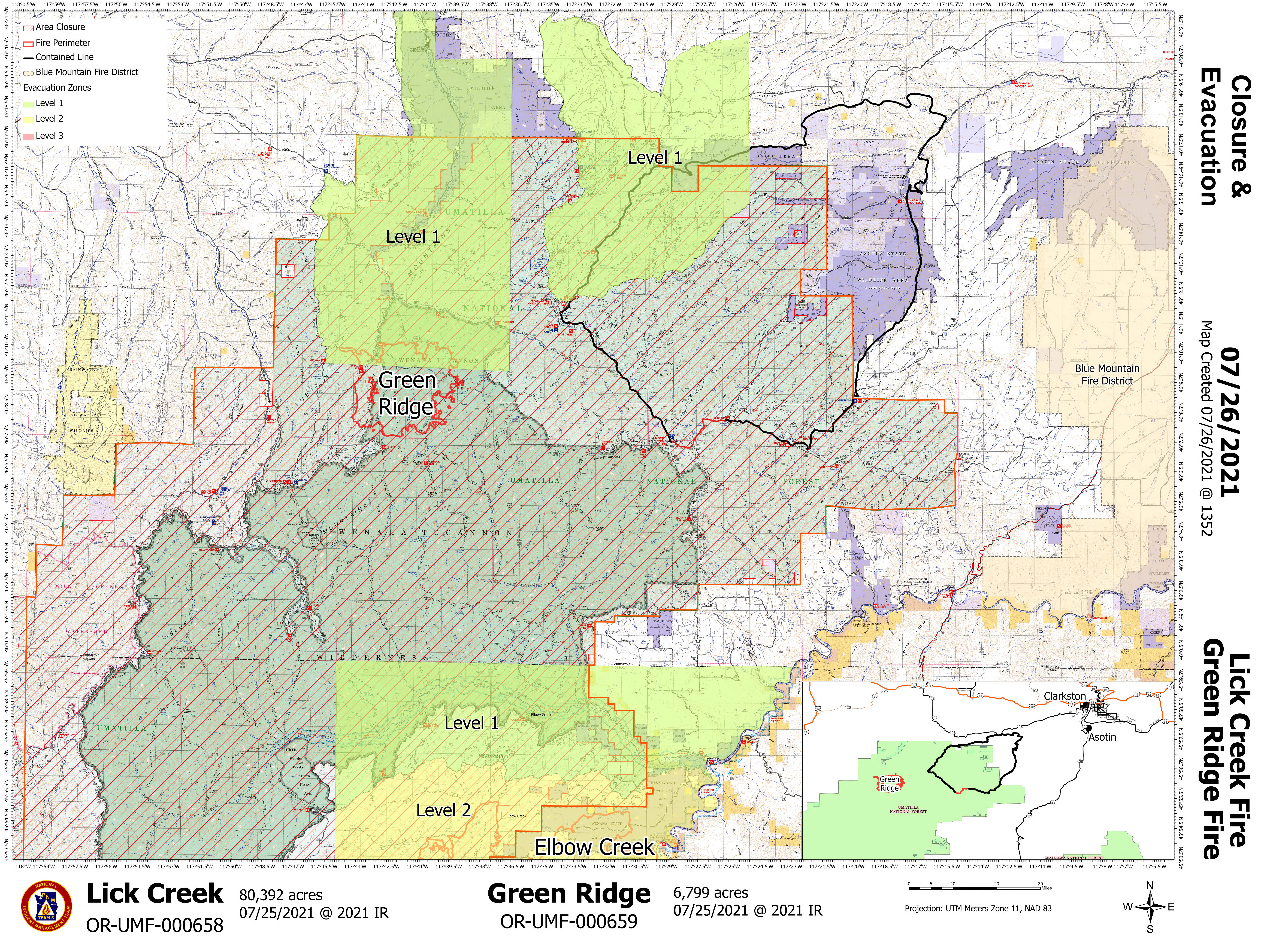
Evacuations: Evacuation zones, and fire perimeter maps are posted on InciWeb at https://inciweb.nwcg.gov/incident/7615 (Lick Creek) and https://inciweb.nwcg.gov/incident/7628/ (Green Ridge).
Closures: All Forest Service lands, roads, and trails within the Umatilla National Forest are closed. For more information visit the Umatilla National Forest website at www.fs.usda.gov/Internet/FSE_DOCUMENTS/fseprd931174.pdf.
Lick Creek Fire
InciWeb Page
Lick Creek Fire Information: 509-780-6238
Lick Creek Fire InciWeb: inciweb.nwcg.gov/incident/7615/
Lick Creek Facebook: Lick Creek Fire
Green Ridge Fire Information: 509-542-7964
Green Ridge Fire InciWeb: https://inciweb.nwcg.gov/incident/7628/
Green Ridge Facebook: Green Ridge Fire
Green Ridge Fire
InciWeb Page
EVACUATION LEVELS CHANGE FOR GARFIELD COUNTY
Related Incident:
Publication Type: Announcement
Effective July 26, 2021, The Garfield County Sheriff’s Office has lifted the Level 1 evacuation area for the Grouse Flats area. The remaining Level 1 evacuation area for Garfield County will remain in effect and be expanded from Mountain Road going East to Columbia County line and North from the Umatilla National Forest boundary to Linville Ridge Road to Blind Grade Road and extending to the Columbia County line.
Evacuation Levels are evaluated daily based on current and forecasted fire activity. Again, the change in current evacuation levels are precautionary.
Lick Creek Update July 28 2021
Related Incident:
Publication Type: News
Lick Creek and Green Ridge Fire Updates – July 28, 2021 – 9:30 a.m.
Tonight at 7:00 p.m. there is a community meeting at the Dayton Fairgrounds 5 N. Pine St., Dayton. Given stable internet service this meeting will be live streamed on the Green Ridge Fire Facebook page for those who cannot attended in person. If there are connectivity issues, the meeting will be recorded and uploaded immediately following. Please feel free to send in any questions through Facebook Live.
Lick Creek Fire: The Lick Creek Fire remains at 90% contained. Continued smoke will be visible as unburned pockets of vegetation inside the fire area are consumed. Crews will continue to monitor and patrol the perimeter until full containment is achieved.
Green Ridge Fire Current Situation: Recent burn operations were successful and provided a blackened edge of fire as an anchor point for crews to extend construction of containment lines along portions of the fire perimeter. Fire leaders are looking for opportunities to create containment lines closer to the fire’s edge with the intent of minimizing fire size. Extensive use of aerial retardant and water drops throughout the last two shifts aided in moderating fire behavior of the spot fire near the 2020 Rattlesnake Fire scar. This allows for safer and expedient work for resources working on the 4022 Road.
As a contingency plan, hand line has been constructed on the ridge adjacent to the Salter Trail and meets with the 4022 Road, where it will extend eastward to connect to the west side of the Lick Creek Fire near Clearwater Lookout area. This involves reopening an old hand and dozer line for reliable containment lines and reducing fuels along those lines.
The fire team has ordered Interagency Hotshot Crews to work in the south and east portions of the fire that are in the Wenaha-Tucannon Wilderness. These crews have specialized abilities and experience in remote and rugged terrain. Their assignment will be to construct hand line between natural terrain features to limit fire spread further into the valuable resources of the wilderness area.
Weather and Smoke Information: Today will be mostly cloudy with a chance of thunderstorms in the morning. A slight chance of showers and thunderstorms could also be experienced this afternoon. Smoke Information is available on the Washington Smoke Blog at: https://wasmoke.blogspot.com/
Evacuations: The remaining Level 1 evacuation area for Garfield County will be expanded from Mountain Road going west to Columbia County line and north from Umatilla National Forest Boundary to Linville Ridge Road to Blind Grade extending to the Columbia County line. If you have any questions, please contact the Garfield County Emergency Management Director, Tina Meier, or Sheriff Drew Hyer at (509)843-3494.
Closures: All Forest Service lands, roads, and trails within the Umatilla National Forest are closed. For more information visit the Umatilla National Forest website at www.fs.usda.gov/Internet/FSE_DOCUMENTS/fseprd931174.pdf
Community Meeting Tonight Dayton Fairgrounds
Related Incident:
Publication Type: Announcement
California Interagency Incident Management Team 12 along with other local officials will be hosting a Community Meeting tomorrow July 28, 2021, at 7:00 p.m. at the Dayton Fairgrounds.
Community Meeting Tonight Pomeroy High School
Related Incident:
Publication Type: Announcement
California Interagency Incident Management Team 12 along with other local officials will be hosting a community meeting tonight July 29, 2021, 7:00 p.m. at the Pomeroy High School, 1090 Pataha St., Pomeroy, CA.
Lick Creek Update July 29 2021
Related Incident:
Publication Type: News
Lick Creek and Green Ridge Fire Updates – July 29, 2021 – 8:00 a.m.
Tonight at 7:00 p.m. there is a community meeting at the Pomeroy High School, 1090 Pataha St., Pomeroy, WA. For those unable to attend, the meeting will be streamed on the Green Ridge Fire Facebook page. (site listed below) There was a community meeting last night in Dayton that was recorded and posted to the fire’s Facebook page.
Lick Creek Fire: A Burn Area Emergency Response (BAER) Team began working on the Lick Creek Fire. While many wildfires cause little damage, some fires create situations that require special efforts to prevent further problems after the fire. Loss of vegetation exposes soil to erosion; runoff may increase and cause flooding, sediments may move downstream and damage houses or fill reservoirs and put endangered species and community water supplies at risk. This fire remains at 90% contained. Continued smoke will be visible as unburned pockets of vegetation inside the fire area are consumed. Crews will continue to mop up pockets of heat interior and patrol the perimeter until full containment is achieved.
Green Ridge Fire Current Situation: The spot fire that has been burning north of the main fire in the Tucannon drainage increased in activity late yesterday. It burned into the main fire and produced a column of smoke that could be seen from a distance. The primary focus is to continue work on direct containment lines along the fire perimeter where trails and roads already exist. At the same time, engines and crews are working on creating contingency containment lines in case the fire escapes beyond the existing direct lines. There is a plan in place to create a third layer of defense with outlying containment points. No effort has been spared to protect the many values at risk in and around the fire area.
The fire team has ordered Interagency Hotshot Crews to work the south and east portions of the fire to keep fire from further spread into the Wenaha-Tucannon Wilderness. Due to the many active wildfires burning in the western US, there are limited resources available to bolster the efforts on this incident and fulfil the plan to achieve full containment and control.
Weather and Smoke Information: A warming trend continues through Friday, and it will be considerably warmer today with lower humidity and increased instability. Smoke Information is available on the Washington Smoke Blog at: https://wasmoke.blogspot.com/
Evacuations: The remaining Level 1 evacuation remains in place for Garfield County. If you have any questions, please contact the Garfield County Emergency Management Director, Tina Meier, or Sheriff Drew Hyer at (509)843-3494.
Closures: All Forest Service lands, roads, and trails within the Umatilla National Forest are closed. For more information visit the Umatilla National Forest website at www.fs.usda.gov/Internet/FSE_DOCUMENTS/fseprd931174.pdf.
Lick Creek Fire Information: 509-780-6238
Lick Creek Fire InciWeb: inciweb.nwcg.gov/incident/7615/
Lick Creek Facebook: Lick Creek Fire
Green Ridge Fire Information: 509-542-7964
Green Ridge Fire InciWeb: https://inciweb.nwcg.gov/incident/7628/
Green Ridge Facebook: Green Ridge Fire
Lick Creek Fire Quick Facts
Start Date: July 7, 2021 Resources:
Cause: Lightning 2 Crews
Containment: 90% 9 Engines
Approx. Size: 80,392 acres 5 Water Tender
Total Personnel: 70 1 Masticators
Location: Approximately 20 miles SW of Asotin, WA