
Incident Publication
Lick Creek Fire Update July 14 2021
Related Incident:
Publication Type: News
Lick Creek (Dry Gulch) Fire Quick Facts
Start Date: July 7, 2021
Approx. Size: 63,533 ac.
Resources:
Cause: Lightning
Containment: 20%
16 Crews
Incident Commander:
Total Personnel: 666
54 Engines
Randy Johnson
Pacific Northwest Team 3
Location: Approximately 2 miles SW of Asotin, WA
12 Dozers
21 Water Tenders
Current Situation: Firefighters working on the Lick Creek Fire are reinforcing the gains made over the last week and constructing additional containment line. The north and east firelines are holding and fire activity is decreasing in those areas. Small spot fires occurred near the southeast perimeter in the area of the snopark on Tuesday and firefighters adjusted tactics to catch those spots before further spread could occur. Line construction and improvement continues in the Dead Horse Springs area. Structure protection work and patrol in the area around the Clearwater Cabins is ongoing.
Last night, fire personnel were on hand to answer questions at a public meeting in Pomeroy. The meeting was well-attended and the firefighters appreciate the support of the local communities.
Today’s Activities: The weather is forecasted to remain steady until mid-afternoon with continued hot temperatures and light winds. Later in the afternoon, winds are expected to increase with gusts up to 25 miles per hour overnight. Depending on alignment of wind and terrain this may aid firefighters by pushing the fire back on itself or it may test containment lines.
Along the north and east sides of the fire, mop-up and patrol efforts are ongoing. These efforts include looking for and extinguishing hot spots that could threaten containment lines. Crews along the west and southwest perimeter, from Clearwater Lookout to the Spruce Spring area, will continue constructing and reinforcing containment lines. This may include burnout, or using fire in a deliberate way to consume burnable vegetation between containment lines and the front of the fire.
Weather and Smoke Info: Hot and very dry weather continues, with relative humidity below 20%. Northwest winds that started around midnight will change to north-northwest in the morning and weaken in the afternoon. Smoke Information is available on the Washington Smoke Blog at: https://wasmoke.blogspot.com/
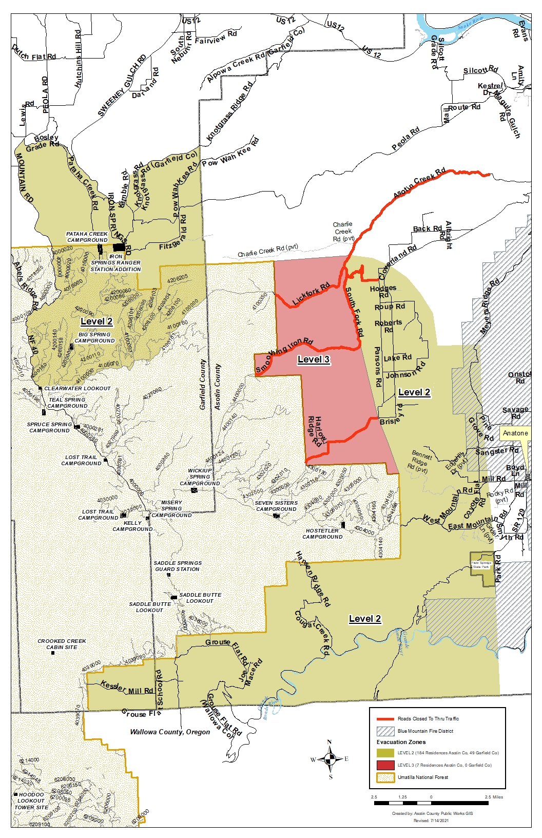
Evacuations: Evacuation zones, and fire perimeter maps are posted on Inciweb at https://inciweb.nwcg.gov/incident/7615. The Red Cross shelter in Clarkston has moved to Echo Hills Church 3215 Echo Hills Dr. in Lewiston, ID. The shelter telephone number is 509-508-1299.
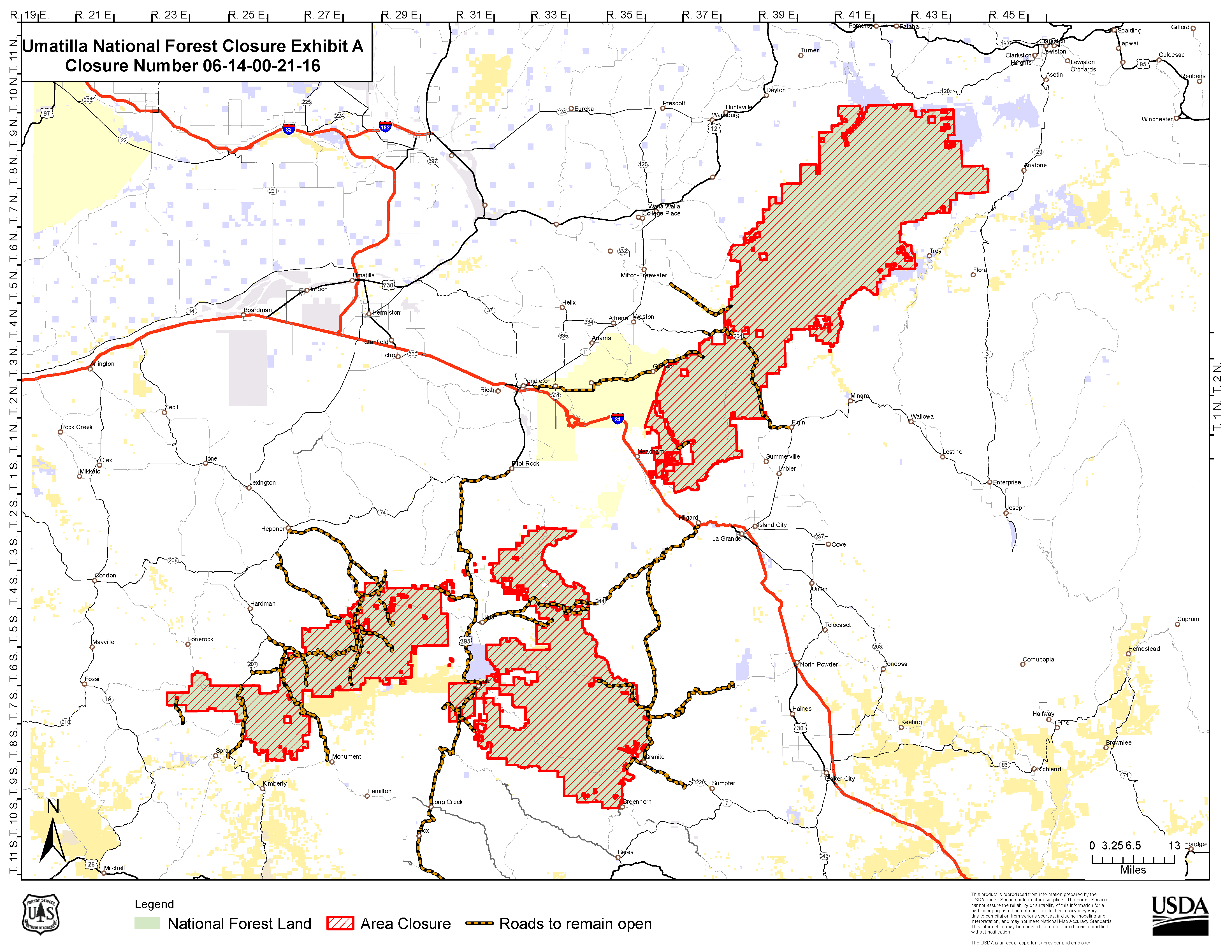
Closures: All Forest Service lands, roads, and trails within the Pomeroy Ranger District of the Umatilla National Forest are closed. For more information visit the Umatilla National Forest website at www.fs.usda.gov/Internet/FSE_DOCUMENTS/fseprd931174.pdf.
Fire Information: 509-780-6238
Inciweb: inciweb.nwcg.gov/incident/7615/
Facebook: Dry-Gulch-Fire
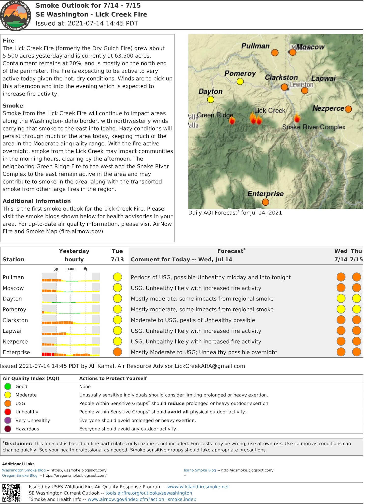
Smoke Outlook 714715
Related Incident:
Publication Type: News
The Lick Creek Fire (formerly the Dry Gulch Fire) grew about 5,500 acres yesterday and is currently at 63,500 acres. Containment remains at 20%, and is mostly on the north end of the perimeter. The fire is expecting to be active to very active today given the hot, dry conditions. Winds are to pick up this afternoon and into the evening which is expected to increase fire activity.
Smoke from the Lick Creek Fire will continue to impact areas along the Washington-Idaho border, with northwesterly winds carrying that smoke to the east into Idaho. Hazy conditions will persist through much of the area today, keeping much of the area in the Moderate air quality range. With the fire active overnight, smoke from the Lick Creek may impact communities in the morning hours, clearing by the afternoon. The neighboring Green Ridge Fire to the west and the Snake River Complex to the east remain active in the area and may contribute to smoke in the area, along with the transported smoke from other large fires in the region.
Evacuation Level Update Jul 14
Related Incident:
Publication Type: Announcement
Out of an abundance of caution the current Level 1 Evacuation Zone will be upgraded to a Level 2 at 5:00 pm, July 14, 2021. The Incident Management Team and Asotin and Garfield County Sheriffs evaluated yesterday’s fire activity and considered this evening’s forecasted west-northwest winds and determined the change to Evacuation Level 2 would be prudent. Evacuation Levels are evaluated daily based on current and forecasted fire activity. Again, the change in current evacuation levels are precautionary.
Please monitor the Asotin and Garfield County Sheriff’s Office Facebook, Dry Gulch Fire.
Facebook and Inciweb: nwcg.gov.incident/7615 for current and updated evacuation maps.
LEVEL 1— Be READY for potential evacuation. Residents should be aware of the danger that exists in their area, monitor emergency services websites and local media outlets for information.
LEVEL 2— Be SET to evacuate at a moment notice. This level indicates there is significant danger to your area, and to be ready to leave at a moment’s notice.
LEVEL 3— GO! means leave immediately. Danger to your area is current or imminent, and you should leave immediately.
Lick Creek Fire Community Briefing on Friday
Related Incident:
Publication Type: News
Pacific Northwest Team 3 will provide a fire briefing for the community on Friday, July 16, at 7pm. The briefing will be at Asotin County Fire Station, 2377 Appleside Blvd. in the Clarkston Heights.
Lick Creek Fire Update July 15 2021
Related Incident:
Publication Type: News
Lick Creek (Dry Gulch) Fire Quick Facts
Start Date: July 7, 2021
Approx. Size: 64,792 ac.
Resources:
Cause: Lightning
Containment: 20%
15 Crews
Incident Commander:
Total Personnel: 629
58 Engines
Randy Johnson
Pacific Northwest Team 3
Location: Approximately 2 miles SW of Asotin, WA
11 Dozers
4 Water Tenders
23 Masticators
Lick Creek (Dry Gulch) Fire Update – Thursday, July 15, 2021 – 9:00 a.m.
There is a community meeting at the Asotin County Fire Station in Clarkston at 7:00 pm tomorrow.
Current Situation: Firefighters on the Lick Creek Fire continually assess tactics and adapt based on factors including weather, terrain, and available resources. Crews patrolling along completed containment lines and controlled small spot fires near Harlow Ridge yesterday. Heavy machinery made progress reinforcing fire lines using dozers and masticators along the southwest side of the fire.
Overnight, crews successfully burned along about five miles of containment line in the southeast to strengthen and deepen fire line. There were a couple of small spot fires located and extinguished in the area pre-treated with retardant. Crews will continue to patrol and respond.
Today’s Activities: A red flag warning was issued for winds and hot, dry temperatures. Patrol and mop up will continue along the north and east perimeter where containment has been established. As smoke clears, fire becomes more active so there may be visible columns of smoke at times today. Crews in the southeast will patrol last night’s burn operation and secure areas where spot fires occur. In the Clearwater Lookout and Spruce Spring area, firefighters will continue constructing and reinforcing containment lines.
Structure teams are in place around the fire area including Rose Springs, Anatone and Grouse Flats.
Weather and Smoke Info: Hot and very dry weather continues, with relative humidity below 20%. West-northwest winds that started around midnight changed to west in the afternoon. Smoke Information is available on the Washington Smoke Blog at: https://wasmoke.blogspot.com/
Evacuations: Evacuation zones, and fire perimeter maps are posted on Inciweb at https://inciweb.nwcg.gov/incident/7615. The Red Cross shelter in Clarkston has moved to Echo Hills Church 3215 Echo Hills Dr. in Lewiston, ID. The shelter telephone number is 509-508-1299.
Closures: All Forest Service lands, roads, and trails within the Pomeroy Ranger District of the Umatilla National Forest are closed. For more information visit the Umatilla National Forest website at www.fs.usda.gov/Internet/FSE_DOCUMENTS/fseprd931174.pdf.
Fire Information: 509-780-6238
Inciweb: inciweb.nwcg.gov/incident/7615/
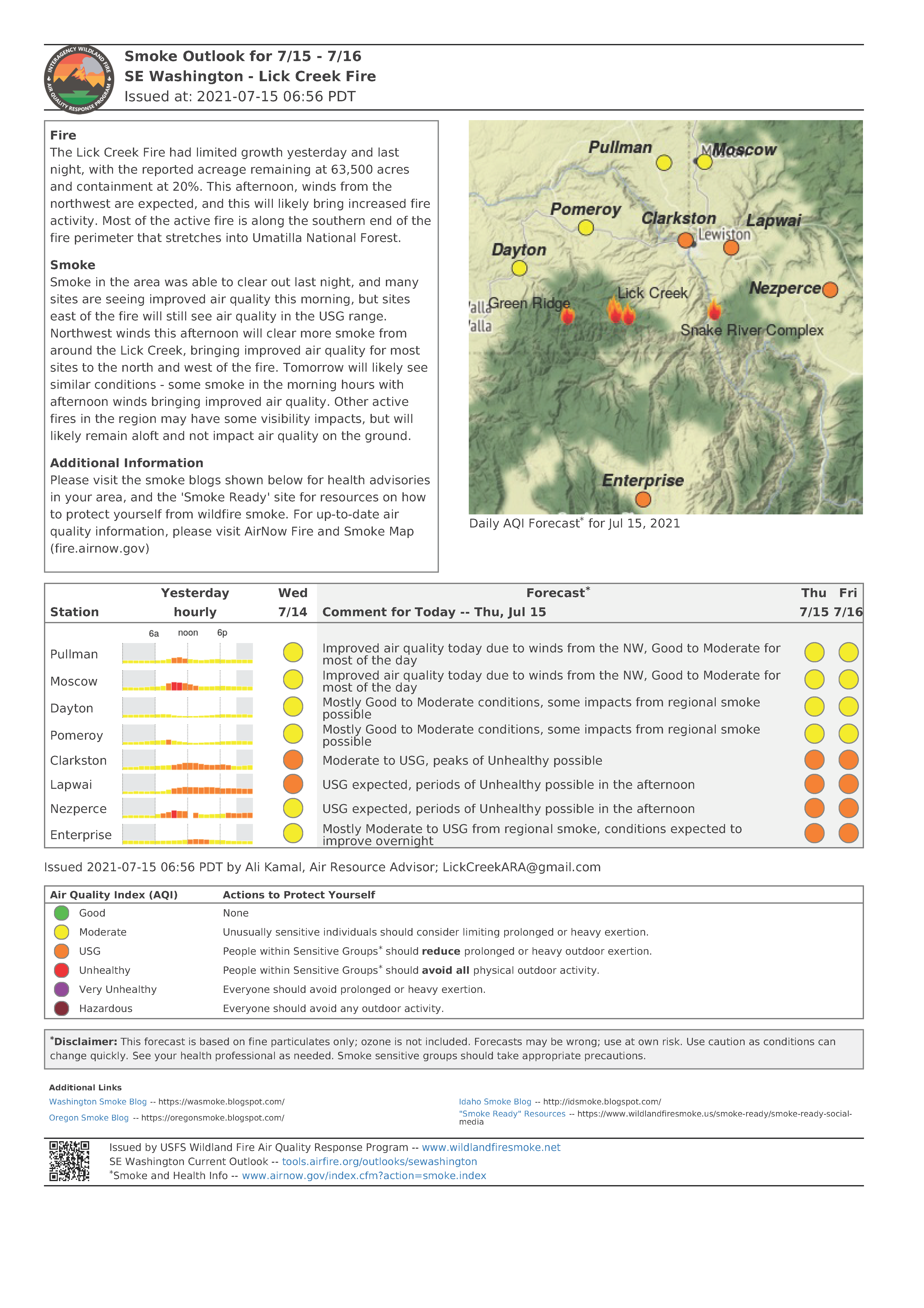
Facebook: Dry-Gulch-FireSmoke Outlook 715 716
Related Incident:
Publication Type: News
The Lick Creek Fire had limited growth yesterday and last night, with the reported acreage remaining at 63,500 acres and containment at 20%. This afternoon, winds from the northwest are expected, and this will likely bring increased fire activity. Most of the active fire is along the southern end of the fire perimeter that stretches into Umatilla National Forest.
Smoke in the area was able to clear out last night, and many sites are seeing improved air quality this morning, but sites east of the fire will still see air quality in the USG range. Northwest winds this afternoon will clear more smoke from around the Lick Creek, bringing improved air quality for most sites to the north and west of the fire. Tomorrow will likely see similar conditions - some smoke in the morning hours with afternoon winds bringing improved air quality. Other active fires in the region may have some visibility impacts, but will likely remain aloft and not impact air quality on the ground.
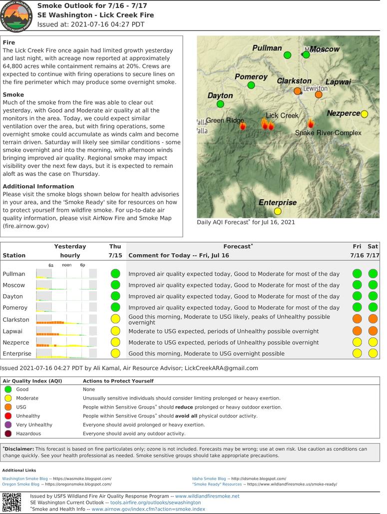
Smoke Outlook 716
Related Incident:
Publication Type: News
The Lick Creek Fire once again had limited growth yesterday and last night, with acreage now reported at approximately 64,800 acres while containment remains at 20%. Crews are expected to continue with firing operations to secure lines on the fire perimeter which may produce some overnight smoke.
Much of the smoke from the fire was able to clear out yesterday, with Good and Moderate air quality at all the monitors in the area. Today, we could expect similar ventilation over the area, but with firing operations, some overnight smoke could accumulate as winds calm and become terrain driven. Saturday will likely see similar conditions - some smoke overnight and into the morning, with afternoon winds bringing improved air quality. Regional smoke may impact visibility over the next few days, but it is expected to remain aloft as was the case on Thursday.
Lick Creek Fire Update July 16 2021
Related Incident:
Publication Type: News
Lick Creek (Dry Gulch) Fire Quick Facts
Start Date: July 7, 2021
Approx. Size: 66,606 ac.
Cause: Lightning
Containment: 30%
Incident Commander: Randy Johnson, Pacific Northwest Team 3
Total Personnel: 686
Location: Approximately 2 miles SW of Asotin, WA
Resources:
15 Crews
11 Dozers
4 Water Tenders
23 Masticaters
58 Engines
Lick Creek Fire Update – Friday, July 16, 2021 – 9:00 a.m.
There is a community meeting at the Asotin County Fire Station in Clarkston at 7:00 pm today.
Current Situation: The containment line on the northern side of the fire continues to hold and firefighters are patrolling the area to secure any hot spots. On the south end of the fire along road 40, crews are mopping up and patrolling the areas where burnout was completed earlier this week. Firefighters are vigilantly watching for potential threats or spots following the high winds experienced yesterday. More depth was gained with further burn out on the west flank. Use of heavy machinery continues as dozers and masticators along the southwest side of the fire reinforce firelines.
Strategic burn operations are being used to strengthen and deepen the fireline. This practice helps reduce the potential of fire spread in the future during even hotter and drier conditions.
Today’s Activities: Burning operations will continue on the southwest portion of the fire if conditions are favorable. Firefighters will be watchful for possible spots. Patrol and mop up will continue along the north and east perimeter where containment has been established. The priority is to keep the fire’s footprint constant and protect the values at risk.
Structure teams are in place around the fire area including Rose Springs, Anatone and Grouse Flats.
Weather and Smoke Info: Temperatures will decrease slightly with an increase in relative humidity. Terrain driven light wind from this morning is expected to increase from the west and northwest in the late afternoon. Smoke will be visible coming from the western side of the fire. Smoke Information is available on the Washington Smoke Blog at: https://wasmoke.blogspot.com/
Evacuations: Evacuation zones, and fire perimeter maps are posted on InciWeb at https://inciweb.nwcg.gov/incident/7615. The Red Cross shelter in Clarkston has moved to Echo Hills Church 3215 Echo Hills Dr. in Lewiston, ID. The shelter telephone number is 509-508-1299. Closures: All Forest Service lands, roads, and trails within the Umatilla National Forest are closed. For more information visit the Umatilla National Forest website at www.fs.usda.gov/Internet/FSE_DOCUMENTS/fseprd931174.pdf.
ADDITIONAL FIRE INFORMATION:
Fire Information: 509-780-6238
InciWeb: inciweb.nwcg.gov/incident/7615/Facebook: Lick Creek Fire
Evacuation Level Update Jul 16
Related Incident:
Publication Type: Announcement
Effectively Immediately Evacuation Zones have been downgraded. Level 3 Evacuation Zone is lowered to a 2. Level 2 Evacuation Zone is lowered to a level 1, however the Grouse Flat area remains in Level 2.
Grouse Flat residence need to remain vigilant to evacuate at a moments notice.
Please monitor the Asotin and Garfield County Sheriff’s Office Facebook, Dry Gulch Fire Facebook and Inciweb: nwcg.gov.incident/7615 for current and updated evacuation maps.
LEVEL 1— Be READY for potential evacuation. Residents should be aware of the danger that exists in their area, monitor emergency services websites and local media outlets for information.
LEVEL 2— Be SET to evacuate at a moment notice. This level indicates there is significant danger to your area, and to be ready to leave at moment’s notice.
LEVEL 3— GO! means leave immediately. Danger to your area is current or imminent, and you should leave immediately.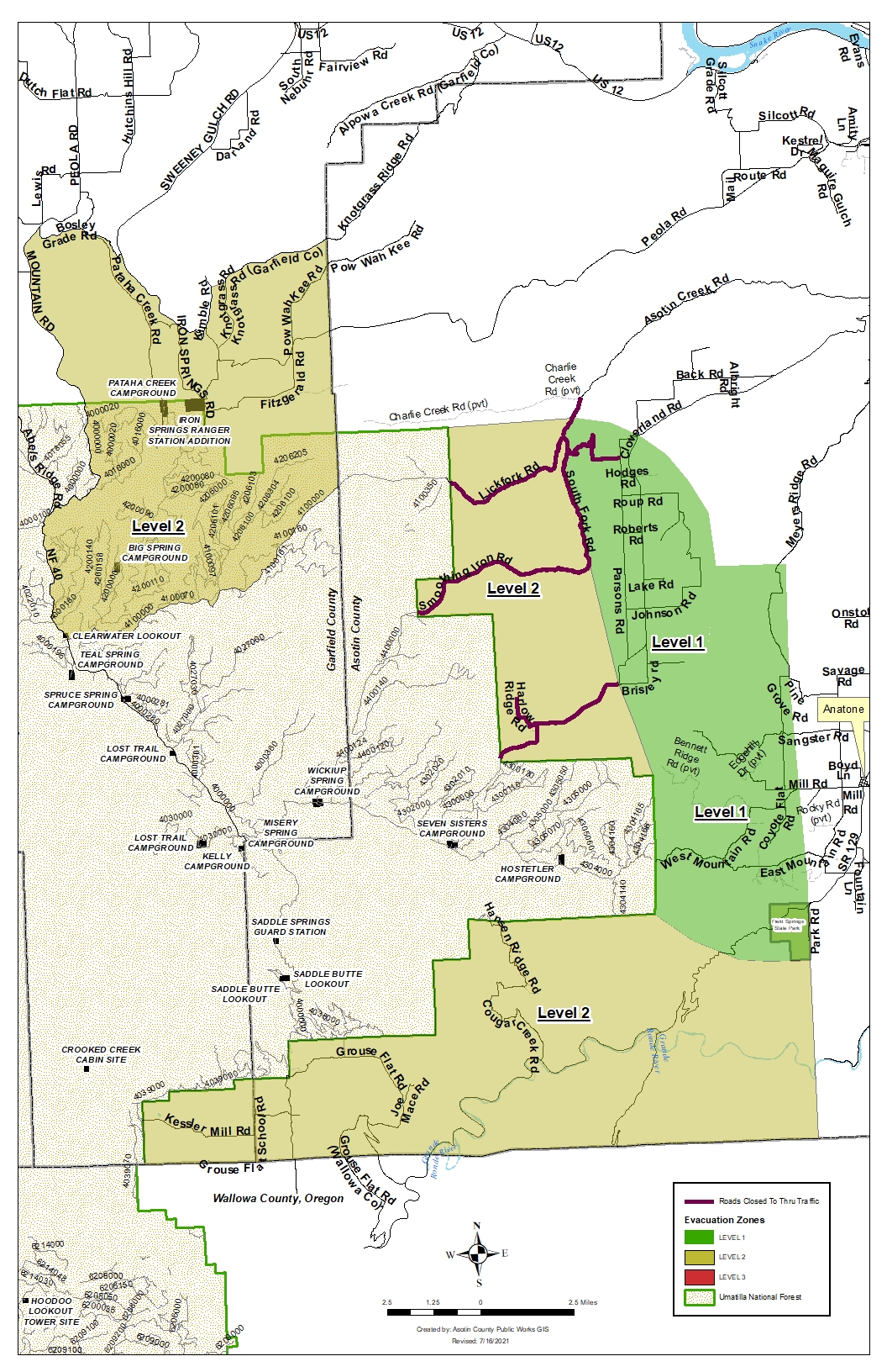
Umatilla National Forest Closure
Related Incident:
Publication Type: Announcement
Umatilla National Forest lands temporarily closed
PENDLETON, Ore. (July 16, 2021) — With persistent extreme hot and dry conditions, active large wildfires, limited firefighting resources and concern for public safety, forest officials have temporarily closed the entirety of the Umatilla National Forest effective immediately. The objective of the closure is to proactively protect public and firefighter safety as the Forest continues to actively suppress large wildfires on the Forest, while also responding to new smoke reports. Hot and dry conditions have challenged firefighters in suppression efforts battling the Lick Creek and Green Ridge Fires on the Pomeroy Ranger District. Additionally, on July 15 the Elbow Creek Fire emerged on the Walla Walla Ranger District, rapidly growing and threatening nearby communities. Overnight, humidity levels have remained extremely low, allowing fires to spread actively. These conditions have created an unprecedented potential for extreme fire spread and intensity. With three active large wildfires on the Umatilla National Forest, compounded by multiple active large wildfires burning across the region, firefighting resources are stretched. Forest officials have implemented the closure for public and firefighter safety.
A full Forest closure means that the public is prohibited from entering any part of Umatilla National Forest at any time, including National Forest lands, roads, trails and recreational facilities. Access on county, state or federal roadways will still be open. Forest Service personnel will attempt to reach as many people as possible to begin vacating campsites and informing individuals who are camping in the Forest currently. The public should cancel any plans for visiting the Umatilla National Forest for the next several weeks. This is a temporary closure and the Forest will continually assess conditions and lift the closure once the unprecedented conditions moderate.
Violating closures and fire restrictions is a violation that carries a mandatory appearance in federal court, punishable as a Class B misdemeanor with a fine of up to $5,000 for an individual or $10,000 for an organization, or up to six months in prison, or both. A detailed map and description of the closure area is available on the Forest website and at any Forest office. Closure barriers and signs will be posted on the ground.
Additional information on the Lick Creek, Green Ridge, and Elbow Fires is available at:
• Lick Creek Fires: https://inciweb.nwcg.gov/incident/7615/
• Green Ridge Fire: https://inciweb.nwcg.gov/incident/7628/
• Elbow Creek Fire: http://bluemountainfireinfo.blogspot.com/
Fire officials want to remind everyone that the current fire danger rating on the Umatilla National Forest is EXTREME.
The National Multi-Agency Coordinating Group has elevated the National Preparedness Level to 5 (PL 5) due to significant fire activity occurring in multiple geographical areas, an increase in incident management team mobilization, and heavy shared resource commitment to large fires nationally. PL 5 is the highest level of wildland fire activity. Several geographic areas are experiencing large, complex wildland fire incidents, which have the potential to exhaust national wildland firefighting resources.
The latest fire information will be posted on the Blue Mountains Fire Information Blog. To receive updates on fires in the Blue Mountains, follow our blog at http://bluemountainfireinfo.blogspot.com/.
Additional information about the Umatilla National Forest is available at: http://www.fs.usda.gov/umatilla.