
Highlighted Media
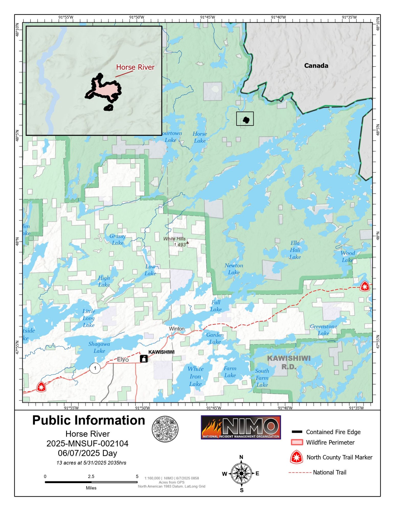
Public Information Office map of Horse River Fire for June 8, 2025. The fire is 100% contained and there will be no other maps.
The Horse River Fire was first detected on May 22, 2025, following a reconnaissance flight over a remote area of the Boundary Waters Canoe Area Wilderness (BWCAW), approximately 16 miles northeast of Ely, Minnesota. The fire was ignited by a lightning strike in a heavily forested, inaccessible area east of the Horse River. It is burning in mixed conifer and hardwood fuels, with minimal blowdown but dense vegetation and swampy terrain limiting ground access.
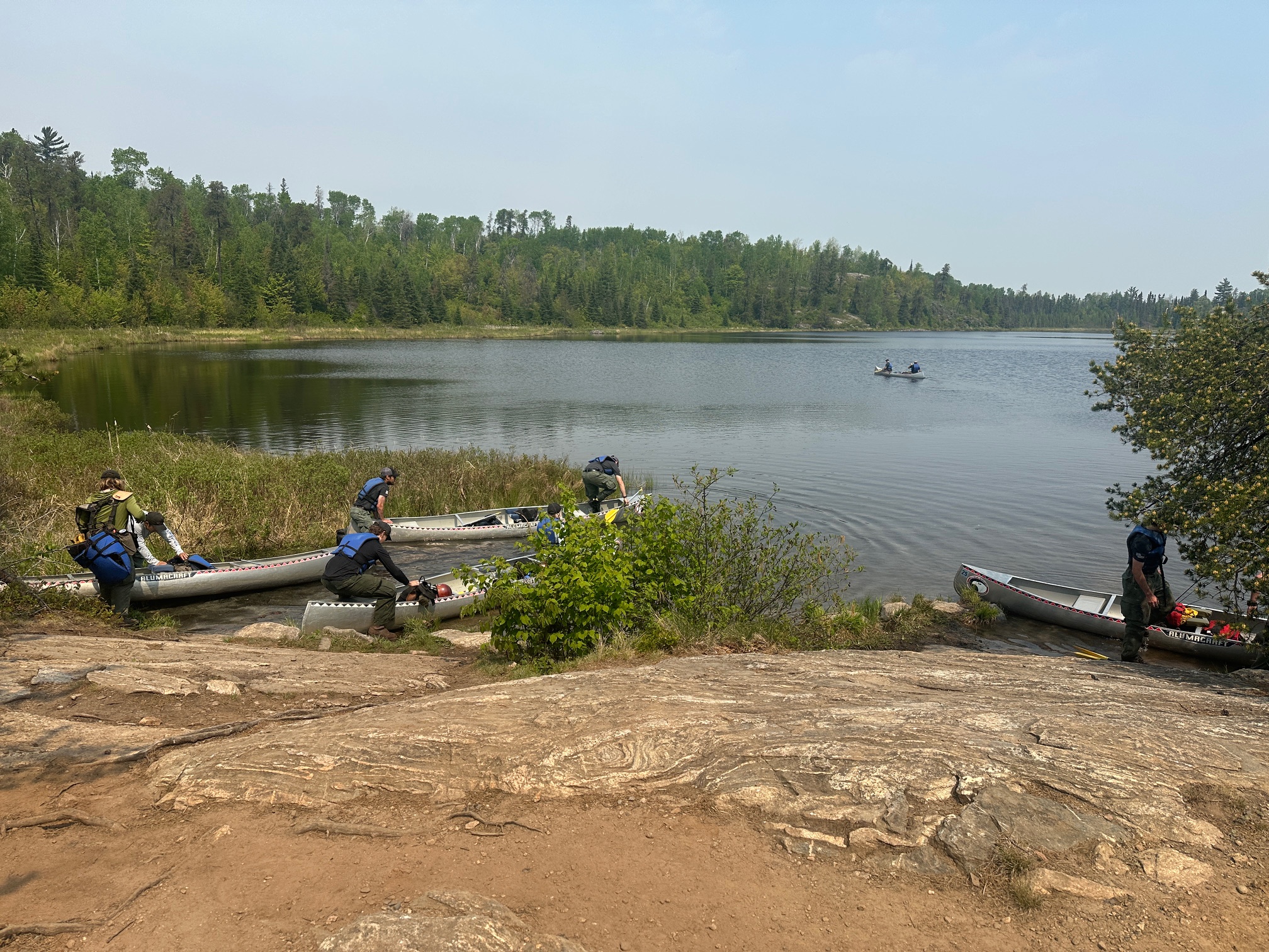
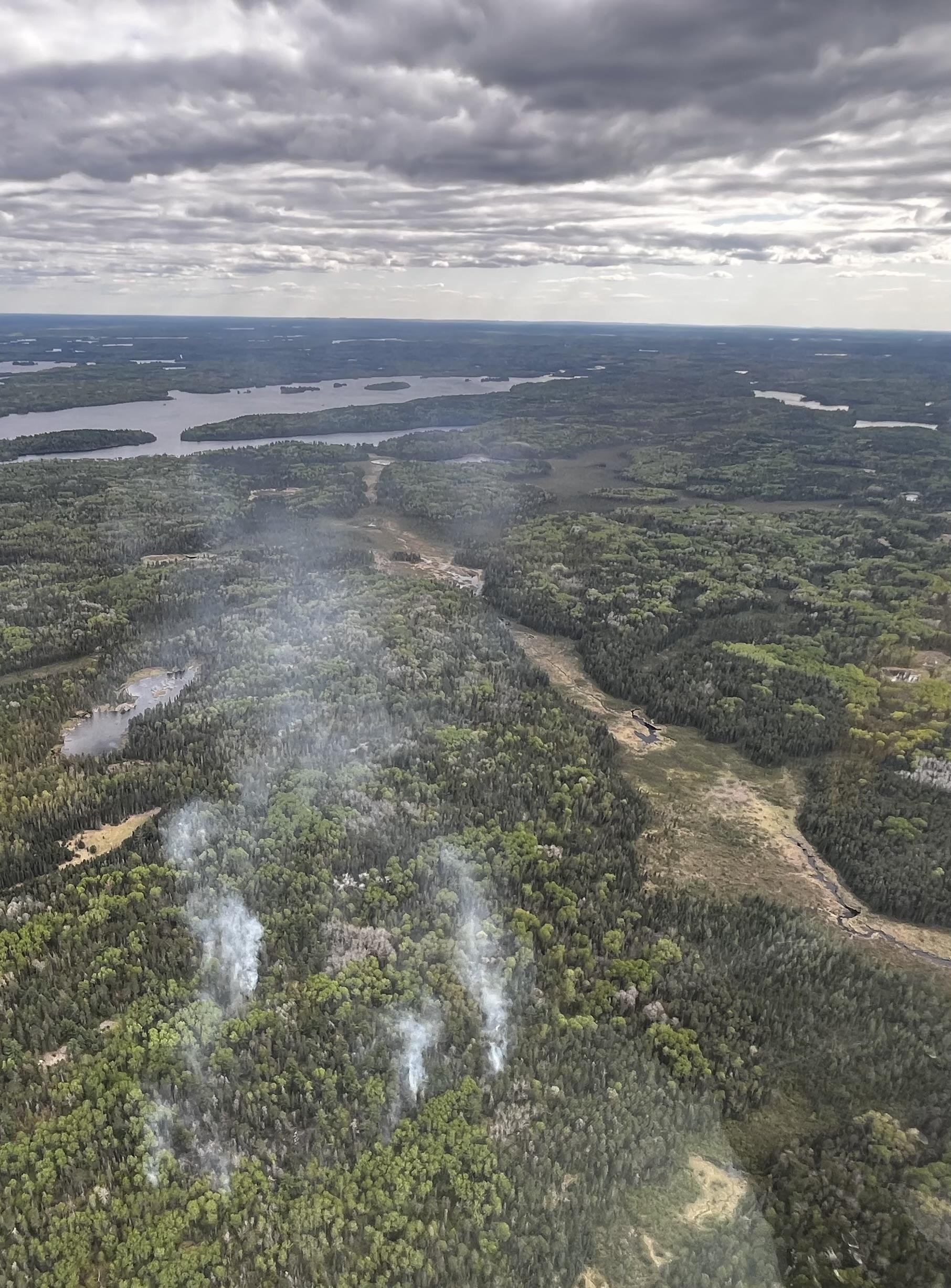
The fire is exhibiting low-intensity fire behavior characterized by smoldering, creeping, and occasional torching. The fire is currently over a mile from the nearest canoe travel route and has not threatened any structures or key infrastructure. Given the isolated nature of the location, suppression efforts have relied heavily on aerial observation and support.
Due to the complexity of managing a wildfire within the protected and rugged terrain of the BWCAW, the National Incident Management Organization (NIMO) team assumed command of the Horse River Fire on May 28, 2025. NIMO teams specialize in overseeing large-scale and high-complexity wildfire incidents, particularly those in sensitive wilderness areas. Their objectives include ensuring firefighter and public safety, minimizing resource impacts, and coordinating strategic suppression efforts using the least intrusive methods available.
The Horse River Fire was first detected on May 22, 2025, following a reconnaissance flight over a remote area of the Boundary Waters Canoe Area Wilderness (BWCAW), approximately 16 miles northeast of Ely, Minnesota. The fire was ignited by a lightning strike in a heavily forested, inaccessible area east of the Horse River. It is burning in mixed conifer and hardwood fuels, with minimal blowdown but dense vegetation and swampy terrain limiting ground access.
The fire is exhibiting low-intensity fire behavior characterized by smoldering, creeping, and occasional torching. The fire is currently over a mile from the nearest canoe travel route and has not threatened any structures or key infrastructure. Given the isolated nature of the location, suppression efforts have relied heavily on aerial observation and support.
Due to the complexity of managing a wildfire within the protected and rugged terrain of the BWCAW, the National Incident Management Organization (NIMO) team assumed command of the Horse River Fire on May 28, 2025. NIMO teams specialize in overseeing large-scale and high-complexity wildfire incidents, particularly those in sensitive wilderness areas. Their objectives include ensuring firefighter and public safety, minimizing resource impacts, and coordinating strategic suppression efforts using the least intrusive methods available.
| Current as of | Mon, 06/09/2025 - 12:33 |
|---|---|
| Incident Time Zone | Central Standard Time |
| Incident Type | Wildfire |
| Cause | Lightning |
| Date of Origin | |
| Incident Time Zone | Central Standard Time |
| Location | Township 65N, Range 11W, Section 26 |
| Incident Commander | NIMO - National Incident Management Organization -NICKIE JOHNNY Incident Commander |
| Incident Description | Lightning wildfire in the Boundary Waters Canoe Area Wilderness, east of the Horse River, Kawishiwi Ranger District. |
| Coordinates |
48° 05' 33.6'' Latitude
-91° 42' 28.8
'' Longitude
|
| Total Personnel: | 23 |
|---|---|
| Size | 13 Acres |
| Percent of Perimeter Contained | 100% |
| Estimated Containment Date | 7/24/2025 |
| Fuels Involved | Coniferous live fuel moistures remain critically low. Grasses are actively growing and hardwoods are leafing out. Heavy fuels remain dry and capable of retaining heat, increasing the risk of flare-ups. Extensive patches of dead balsam fir remain due to previous spruce beetle outbreaks. Numerous falling snags have been reported throughout the incident area, posing safety hazards. |
| Significant Events | Cooler weather for the week will moderate fuel moistures. The Build-Up Index (BUI), which measures how dry and flammable forest materials are, will stabilize this week and fine fuels should become less available for the foreseeable future. Much of the Horse River Fire footprint has self-extinguished, with no heat detected in the two previous operational periods. |
| Planned Actions |
Resources will continue to implement direct attack strategy. |
|---|---|
| Projected Incident Activity |
12 Hours: No heat anticipated. 24 Hours: No heat anticipated and increasing chances of rain increase the probability of containment. 48 Hours: No fire behavior anticipated. |
| Weather Concerns | Observed: Partly cloudy skies continue today with brisk south winds gusting near 20 mph during the afternoon. Predicted: After a line of thunderstorms moves through on Saturday night, showery conditions will continue Sunday and Sunday night, with another round on Monday. Most of the initial rainfall accumulation will be with the initial line of thunderstorms, but wetting rainfall will continue through the day Monday. Brief high pressure builds back across the region Tuesday and Wednesday. |
|---|