
Kootenai River Complex Fire Fact Sheet 10282022
Related Incident: Kootenai River Complex
Publication Type: News
Kootenai River Complex Update Friday, October 28, 2022
Facebook: https://www.facebook.com/USFSIPNF
Idaho Panhandle National Forests, Bonners Ferry Ranger District
![]() Phone: (208) 557-8813
Phone: (208) 557-8813
**Additional updates will occur only if there is a change in conditions**
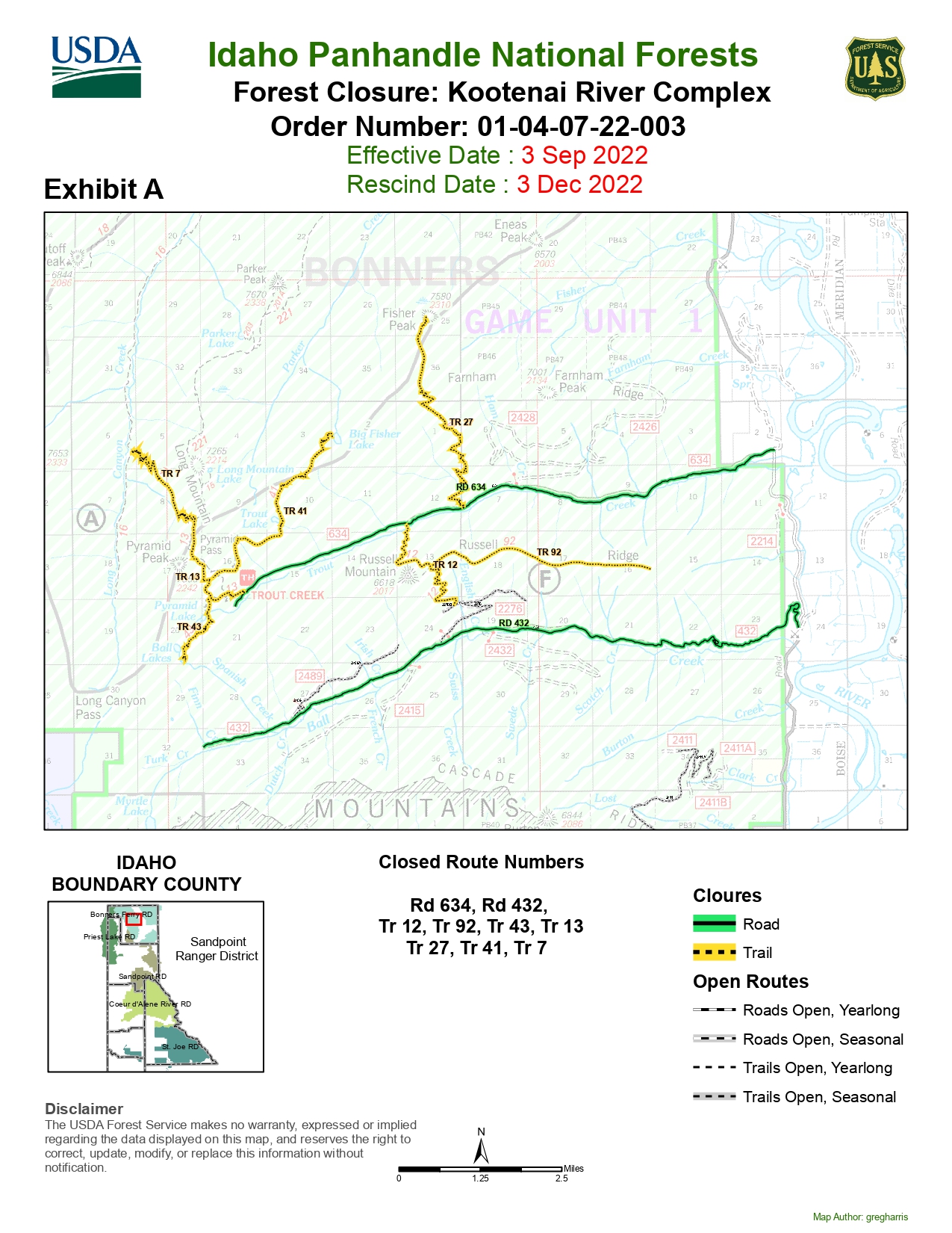
Location: 7 miles NW of Bonners Ferry, ID, in Boundary County, ID Size: 25,402 acres
Personnel: 9 Completion: 100% Incident Commander: ICT4 Ohweiler
Highlights: There is minimal fire activity with some flanking, backing, and creeping. The fire is a mix of timber fuels including subalpine fir, lodgepole, larch, cedar, and mixed shrub understory with huckleberry. Heavy dead and down logs combined with standing dead trees along with steep topography pose a hazard to firefighters.
This time of year, fire activity is significantly reduced due to precipitation, shorter days, lower temperatures, and higher daytime humidity[MKF1] [BJFNI2] [BJFNI3] . Expect to see continued smoke until the snow falls or significant rain occurs. Still, with decreased fire behavior, the threat is much less than it was earlier in the season. In areas around properties where the threat is significantly reduced, like those with cold burned areas around them, crews are assessing where structure protection equipment like pumps and hoses can be taken down.
Firefighters plan to conduct suppression repair actions where appropriate in the areas around Trout Road and Ball Creek Road. Using heavy equipment and hand tools firefighters work to take measures to repair damage to areas where firefighting action has occurred as well as remove some lingering dangers left by the fire. During this time firefighters will continue to remove handlines, hoses, and sprinkler systems, and work to remove snags while reassessing the area dangers and safety concerns as it impacts public use and travel. During this work, firefighters will create log decks and slash piles as they remove hazardous fuels and restore natural areas. THESE LOG DECKS ARE NOT FOR PUBLIC CONSUMPTION. When venturing out please note that taking from these piles is PROHIBITED.
Closures & Evacuations: Where possible, closures have been reduced. Effective 10/28/2022, the following roads and trails are now open:
McGinty Ridge Trail (No. 143) and Clifty Trail (No. 182) and Cascade Creek Road (FS 2411) and Fisher Peak Trail (No. 7)
The following National Forest Trails and Roads remain closed while firefighters reassess the safety concerns for public use:
The entirety of Ball Creek Road (FSR 432), Trout Creek Road (FSR 634), and Burton Road (FSR 2411). Also, the Parker Ridge Trail (No. 221), Russell Mountain Trail (No. 12), Russell Ridge Trail (No. 92), Ball & Pyramid Lakes Trail (No. 43), Pyramid Pass Trail (No. 13), Pyramid Peak Trail (No. 7), Fisher Peak Trail (No. 27), Myrtle Peak Trail (No. 286), Burton Peak Trail (No. 9), Trout Lake Trail (No. 41), and Long Canyon Trail (No. 16).
Please note that after our post-fire BAER team analysis, multiple high-risk hazards remain such as potential rock & debris slides, down trees, and snags; the public should NOT EXPECT Trout Creek Road (FSR634) and Ball Creek Road (FSR 432) to reopen until next year.
Changes in closure status will be promptly shared. There are NO evacuations. However, when living in fire-prone areas, it is recommended that all area residents have an evacuation plan in place, including having all important documents, pictures, prescriptions, and pets gathered up and quickly transportable. Residents of Boundary County, ID can visit https://www.nixle.com or text their home zip code to 888777 to sign up for emergency alerts.
Weather: Widespread wetting precipitation is expected to persist over most of the area. Several systems are expected throughout the week, resulting in a prolonged wet and cool period.
Hunting in the IPNF: The Idaho Panhandle National Forests encourages visitors to enjoy their public land by following travel management guidelines to minimize erosion impacts, aid in wildlife protection, provide non-motorized recreation and hunting opportunities, and protect natural resource values. Specific closure area information for the Idaho Panhandle National Forests, including maps, are posted on the IPNF Alerts & Notices web page (https://www.fs.usdalgov/alerts/ipnf/alertsnotices) statewide information on fires and closures is provided on the Idaho Department of Fish and Game’s Fire Map web page (https://idfg.idaho.gov/ifwis/maps/realtime/fire/) Prescribed fire plans can be found at http://bit.ly/NorthIdahoRxFire. In the opened areas, the public should be prepared to meet heavy equipment and other traffic on roads; be aware that weather conditions such as precipitation and wind can rapidly change conditions on the ground, especially in fire areas. Wind can blow trees across roadways and trails, and precipitation can wash debris across roads and trails, blocking access and raising stream and river levels. Forest visitors must be prepared to stay longer than expected due to changing circumstances. Preparing for the unexpected is the best plan.
###
Diamond Fire Fact Sheet 10272022
Related Incident: Diamond Watch Fire
Publication Type: News
Diamond Watch Wildfire Update Thursday, October 27, 2022
Facebook: https://www.facebook.com/USFSIPNF
Idaho Panhandle National Forests, Priest Lake Ranger District
Phone: (208) 557-8813
**Additional updates will occur only if there is a change in conditions**
Location: 5.5 miles west of Nordman, ID, in Pend Oreille County, WA
Size: 1,4429 acres Personnel: 16 5 Containment: 80% Incident Commander: ICT4 Hirst[MKF1]
Overview: The lightning-caused Diamond Watch Fire was detected on the evening of July 14th. The fire is visible from ID Highway 57 near Priest Lake and is burning on a ridge east of Diamond Peak, located 5.5 miles west of Nordman, ID, in Pend Oreille County, WA. The fire is primarily burning in timber litter with jackpots of heavier fuels under a dense canopy. The brush component has been in a heat sink with higher live fuel moisture than average and is slowing fire spread when encountered. Firefighters and public safety remain the top priority.
Planned Actions: The firefighters plan to conduct suppression repair actions in the area south and west of Diamond Creek/657 Road, north and east of 308 roads. Using heavy equipment and hand tools firefighters work to take measures to repair damage to areas where firefighting action has occurred as well as remove some lingering dangers left by the fire. During this time firefighters will begin to remove handlines, hoses, and sprinkler systems; and work to remove snags while reassessing the area dangers and safety concerns as it impacts public use and travel. During this work, firefighters will create Log Decks and Slash piles as they remove and restore natural areas. THESE LOG DECKS ARE NOT FOR PUBLIC CONSUMPTION, please when venturing out know that taking from these piles is PROHIBITED.
Weather: Normal seasonal temps in the 30s to 40s with a moderated chance of rain this coming week will allow for slow to minimal fire growth. Smoke can still be seen from some areas still smoldering from the fire.
Closures & Evacuations: Closures for Forest Service Roads 311, 308, 1362H, and the area near the Diamond Watch Fire will be rescinded on 10/27/2022. Timing will depend on when crews are finished with snagging operations on FSR 308. Please keep in mind that personnel is still working in the area, and you may encounter firefighting traffic.
Forest Service Road 657 remains closed to public use
There are NO evacuations. However, when living in fire-prone areas, it is recommended that all area residents have an evacuation plan in place, including having all important documents, pictures, prescriptions, and pets gathered up and quickly transportable. Residents of Bonner County, ID, or Pend Oreille, WA, can visit https://www.nixle.com or text their home zip code to 888777 to sign up for emergency alerts.
Hunting in the IPNF: The Idaho Panhandle National Forests encourages visitors to enjoy their public land by following travel management guidelines to minimize erosion impacts, aid in wildlife protection, provide non-motorized recreation and hunting opportunities, and protect natural resource values. Specific closure area information for the Idaho Panhandle National Forests, including maps, are posted on the IPNF Alerts & Notices web page (https://www.fs.usdalgov/alerts/ipnf/alertsnotices) statewide information on fires and closures is provided on the Idaho Department of Fish and Game’s Fire Map web page (https://idfg.idaho.gov/ifwis/maps/realtime/fire/) Prescribed fire plans can be found at http://bit.ly/NorthIdahoRxFire. In the opened areas, the public should be prepared to meet heavy equipment and other traffic on roads; be aware that weather conditions such as precipitation and wind can rapidly change conditions on the ground, especially in fire areas. Wind can blow trees across roadways and trails, and precipitation can wash debris across roads and trails, blocking access and raising stream and river levels. Forest visitors must be prepared to stay longer than expected due to changing circumstances. Preparing for the unexpected is the best plan.
###
Forest Service Burned Area Emergency Response BAER Team Conducts Postfire Assessment of fires on the Mt BakerSnoqualmie National Forest
Related Incident: Mt. Baker-Snoqualmie Post-Fire BAER
Publication Type: News
The Mt. Baker-Snoqualmie National Forest (MBSNF) has re-convened a BAER team to re-assess National Forest System (NFS) lands impacted by the Bolt Creek, Boulder Lake, and Suiattle River Fires. A previous BAER team had completed an assessment on most of these fires, however, due to the unseasonably late fire season another assessment was determined to be needed to reassess changes in wildfire impacts from the previous assessment. This assessment will also include the Loch Katrine fire which was not previously assessed.
Information about the fires can be found online at: Bolt Creek Fire https://inciweb.nwcg.gov/incident-information/wanws-bolt-creek-fire, Suiattle River, Boulder Lake and Loch Katrine Fires https://inciweb.nwcg.gov/incident-information/wamsf-loch-katrine-fire.
After a large wildfire, special actions may be necessary to provide for public and community safety and protect critical natural and cultural resources from post-fire events like soil erosion and flooding. BAER teams focus on emergency actions necessary to protect human life and safety, property, and natural and cultural resources, including affected watersheds. BAER assessments identify unacceptable risks on federal lands from post-fire threats and help land managers prepare burned areas for potential threats from rainstorms.
The Forest Service BAER team on the MBSNF consist of hydrologists, soil scientists, botanists, biologists, archaeologists, engineers, and geographic information system (GIS) specialists. The BAER program uses ground and aerial surveys, satellite imagery and computer models to evaluate conditions and recommend emergency treatments to protect values at risk from further damage. The first step in the BAER assessment process is to take pre-fire and post-fire satellite imagery and data to produce a soil burn severity map, which will provide baseline information on changed watershed conditions and potential watershed impacts from the fire.
The BAER team will coordinate and share information from their assessment with other federal agencies, as well as state agencies and local counties and municipalities who work with adjacent and downstream private homeowners, landowners, and businesses to prepare for potential post-fire flooding and debris flow impacts.
For additional information about the BAER assessment and to view the report once it is completed visit: https://inciweb.nwcg.gov/incident-information/wamsf-mt-bakersnoqualmie-postfire-baer. The BAER team’s assessment report will include recommended emergency stabilization treatments and actions, if any, designed to decreased possible impacts to critical values from the burned areas during rainstorm events such as: life and safety, property, critical natural resources, and cultural resources.
BAER SAFETY MESSAGE: Everyone near and downstream from the burned areas should remain alert and stay updated on weather conditions that may result in heavy rains and increased water runoff. Flash flooding may occur quickly during heavy rain events – be prepared to act. Current weather and emergency notifications can be found at the National Weather Service website: www.weather.gov/abq/.
Goat Rocks Siouxon and Sunset Fires Update October 28 2022
Related Incident: Goat Rocks FireSiouxon and Sunset Fires
Publication Type: News
Management of fires transitioning back to the Gifford Pinchot National Forest
The Rocky Mountain Complex Incident Management Team (CIMT) Three will return management of the fires to the Gifford Pinchot National Forest tomorrow morning at 7:00 a.m. Rocky Mountain CIMT Three would like to thank the businesses, hoteliers, restauranteurs, and the community at large for their kindness and support of the IMT and firefighters.
Current Situation: Rainy, cool weather is expected to continue into next week around the Goat Rocks, Siouxon, and Sunset fires. With the low probability of fire spread and difficulties completing repair work until after soils dry out, many resources are being released from the fires today and through the weekend.
The Goat Rocks, Siouxon and Sunset fires are still burning, including in logs, stumps, roots, and deep duff. Work will continue on the fires as needed and as the weather allows. A limited number of engines, crews, and other fire personnel will remain to conduct fire patrols and continue suppression, clean-up and repair operations when and where it is safe to do so. Fire activity and smoke production will increase during warmer and drier weather, and may be visible from Packwood and US 12. Additional resources will be assigned to the fire as needed to conduct fire suppression and repair work.
Forest closures will remain in effect for the fire areas for the foreseeable future. Hazardous conditions persist in the burned areas, including fire-weakened trees, areas of active burning, hot ash pits, and rolling debris. Falling trees are blocking roads and could strike passing or parked vehicles. Trees and rocks will fall in greater numbers during heavy rains and when it is windy. Many roads are also narrow with little room for passing vehicles. Forest officials urge the public to continue to observe the forest closures for both public and firefighter safety.
Information for the Goat Rocks, Siouxon, and Sunset fires will be available on InciWeb and the Gifford Pinchot National Forest Facebook sites. Future updates will occur twice a week starting next week.
Weather Information: Rain will return today into tomorrow, with the snow level rising to around 5,000 to 6,000 feet. Monday will be the start of a cooling trend, with snow levels falling Tuesday to around 3,000 feet. Please slow down and watch for slick roads.
Forest Closures: A full list of closures in place for the Goat Rocks, Siouxon, and Sunset fires can be found under “Alerts & Notices” on the Gifford Pinchot National Forest website.
Fire Danger: The Fire Danger Rating on the Gifford Pinchot National Forest is LOW. Industrial Fire Precaution Level (IFPL) Zones 659S (Goat Rocks Fire) and 660 (Siouxon and Sunset fires) are Level I on USFS lands.
The Temporary Flight Restriction has been lifted for the Goat Rocks Fire vicinity.
Settings - change map background and toggle additional layers
Filter - control incident types displayed on map.
Zoom to your location
Reset map zoom and position
Could not determine your location.
Show Legend
 Wildfire
 Prescribed Fire
 Burned Area
Response
Burned Area
Response Other
Other
2022 Burro Fire
Unit Information
Incident Contacts
Cedar Creek Fire Update Spanish October 27 2022
Related Incident: Cedar Creek Fire
Publication Type: News
Resumen del Incendio Cedar Creek
Extensión: 127,283 acres Origen: 15 millas E de Oakridge, OR Recursos: 4 camiones;
Contenido: 60% Causa: Relámpagos 2 Grupos; 1 helicóptero;
Personal: 222 Fecha de Inicio: 1ro agosto, 2022 2 Masticadores
**Reunión comunitaria, hoy martes, a las 5:30 pm, en el Auditorio de la Escuela Secundaria en Oakridge**
**Reunión transmitida en vivo en la página de Facebook para el Incendio de Cedar Creek**
Condiciones climáticas: El jueves, se observará un clima seco y cálido con altas temperaturas a mediado de los 50 grados. Se experimentará la presencia de un sol intermitente y nubes considerablemente elevadas.
La humedad relativa alcanzará su punto más bajo durante varios días, pero permanecerá en un 50%. Con la llegada de lluvias ligeras y cierta cantidad de nieve, se anticipa la continuación de un clima seco hasta el viernes en horas del anochecer.
Operaciones realizadas: Cabe recalcar que, con la precipitación dada recientemente, se está tratando de asegurar la vida de los bomberos trabajando en el interior y alrededor de la línea de fuego. Su seguridad es un aspecto primordial en el Incidente. Las carreteras sobre las cuales se están movilizando, también siguen siendo evaluadas cautelosamente con la finalidad de asegurar la salud y la seguridad del personal de bomberos.
En cuanto el estado de las rutas de acceso se mejore, los bomberos regresaran a la línea del incendio para completar los trabajos de reparación y rehabilitación de las líneas construidas a mano y con las construidas con la ayuda de bulldozers. Se continúan generando emanaciones de humo desde el interior de capas profundas de material de combustión pesado. Para el día de hoy y mañana, con el arribo de un periodo corto de sequía, aun con las cantidades de humo que se han estado disminuyendo, se lograra observar áreas manteniendo calor a veces y presentándose en forma de llamas y columnas de humo, con la posibilidad de generar cantidades mayores de humo que las experimentadas en los últimos días. Podría verse impactada la calidad del aire, hasta que el próximo Sistema húmedo del clima se logre introducir este fin de semana. Mientras se da la transición del manejo del incendio hacia una organización más pequeña y los trabajos en la zona de Oakridge en donde paso el incendio continúen, por favor tome en cuenta la incrementación del tráfico sobre la carretera 58, incluyendo maquinaria pesada y trailers.
Cierres de camino: Actualmente, se emitió una reducción en la orden de cierre de caminos para los Bosques Nacionales de Deschutes y Willamette. Estas órdenes permanecerán en pie hasta que se haya realizado un estudio del peligro en las zonas que han sido fuertemente impactadas por el incendio y los bomberos hayan eliminado estos peligros. Por favor respete las ordenes de cierre de caminos para su seguridad y la de los bomberos. Para información actual y mapas, visite: Willamette National Forest y Deschutes National Forest. Se recomienda para los excursionistas en el sendero de Pacific Crest Trail, que visiten pcta.org para mantenerse informados del avance en el incendio. Se levanto la orden temporal de vuelos sobre la zona del Incendio Cedar Creek debido a la reducción de aviones necesarios para las operaciones del incendio.
Condiciones del Humo: Debido a la presencia del humo, se esperan condiciones de la calidad del aire entre el rango de Buenas a Moderadas en el pronóstico para esta área. Para información actual, lea Fire.airnow.gov, oakridgeair.org, y LRAPA - Today's Current Air Quality. Pronósticos del humo están disponibles en https://outlooks.wildlandfiresmoke.net/outlook
Evacuaciones: Las evacuaciones que estaban en pie, han sido levantadas para el condado de Lane. Por favor, si necesita información actualizada en los cambios dados en el incendio visite, Lane County Sheriff’s Office, 541-682-4150 y la Oficina del Alguacil del condado de Deschutes (Deschutes County Sheriff’s Office), 541-693-6911
Online: https://inciweb.nwcg.gov/incident/8307/
www.facebook.com/CedarCreekFire2022/
www.tinyurl.com/cedarcreekfireyoutube
Línea informativa: 541-201-2335, 8:00 AM – 8:00 PM
Para consultas con Medios comunicativos: 541-327-9925
Email: 2022.cedarcreek@firenet.gov
Cedar Creek Fire Update October 27 2022
Related Incident: Cedar Creek Fire
Publication Type: News
Cedar Creek Fire Quick Facts
Size: 127,283 acres Origin: 15 miles E of Oakridge, OR Resources: 4 engines;
Containment: 60% Cause: Lightning 2 crews; 1 helicopter;
Total personnel: 222 Start Date: August 1, 2022 2 Masticators
**Community Meeting is today at the Oakridge Highschool Auditorium 5:30 p.m.**
**Community Meeting to be livestreamed on the “Cedar Creek Fire” Facebook page.**
Weather: Thursday will be noticeably drier and warmer with high temperatures in the mid 50s. There will be considerable high clouds and intermittent sunshine. Relative humidity will dip to its lowest point in several days but remain above 50%. The dry weather is anticipated to continue until Friday night when the light rain and snow may return.
Operations: With the recent precipitation, firefighter safety in and near the fire line continues to be top priority. Travel routes remain closely monitored and patrolled to ensure the health and safety of fire personnel. As access continues to improve, fire crews will return to the fire line to complete repair and rehab of handlines and dozer lines.
Smoke continues to be generated in heavy fuels and deep layers. Although the amount of smoke is slowly becoming less and less, with a short dry period coming today and tomorrow, those areas holding heat have the potential to smolder, burn, and generate more smoke than has been seen the past few days. Air quality may be impacted until the next wet weather system moves through over the weekend.
As the transition to a smaller fire organization and footprint at the Oakridge fire camp continue, be aware of increased traffic involving larger equipment and trailers along Highway 58.
Closures: There are updated, reduced closures in effect on both the Deschutes National Forest and Willamette National Forest. These closures will remain in place until areas impacted by the fire are surveyed for safety risks and fire crews are able to mitigate these hazards. Please respect Forest closures for firefighter and public safety. Please visit Willamette National Forest and Deschutes National Forest for the most recent closure orders and maps. Pacific Crest Trail hikers should visit pcta.org for current information. The Temporary Flight Restriction over the Cedar Creek Fire area has been lifted due to a reduction of aircraft needs for fire operations.
Smoke: Air quality conditions due to smoke are expected to range from good to moderate within the forecast area. For current conditions, see Fire.airnow.gov, oakridgeair.org, and LRAPA - Today's Current Air Quality. Smoke Forecast Outlooks are available at https://outlooks.wildlandfiresmoke.net/outlook.
Evacuations: The remaining evacuations for Lane County have been lifted. Please check with Lane County Sheriff’s Office at 541-682-4150 and Deschutes County Sheriff’s Office at 541-693-6911 for updates and changes.
Online: https://inciweb.nwcg.gov/incident/8307/
www.facebook.com/CedarCreekFire2022/
www.tinyurl.com/cedarcreekfireyoutube
Fire Information Line: 541-201-2335, 8:00 AM – 8:00 PM
For Media Inquiries: 541-327-9925 | Email: 2022.cedarcreek@firenet.gov
Goat Rocks Siouxon and Sunset Fires Update October 27 2022
Related Incident: Siouxon and Sunset Fires
Publication Type: News
Resources return home amid season-ending weather events
Current Situation: The wet conditions that had persisted over the Goat Rocks, Siouxon, and Sunset fires briefly lifted on Wednesday. Certainty has built that recent and forecasted precipitation will be a season-ending event for wildland fires in the area. Fire resources no longer needed for remaining fire suppression activities are being released from the incident. Traffic is expected to be heavy in Packwood on Thursday as firefighters begin returning home to prepare for their next assignment. The brief break in weather between storm systems gave pilots an opportunity to move the four helicopters that had been stationed at the Packwood Airport to other locations.
On Thursday, crews remaining on the Goat Rocks Fire will continue the previous days’ work of patrolling areas along the fires’ perimeters where it is safe to do so. They will continue post-fire suppression cleanup – removing the remaining equipment, flagging, and all other items left after the past weeks of firefighting. On the Siouxon and Sunset fires, crews will continue patrolling the area and addressing remaining hot spots near the fire’s edge that they can safely engage.
As temperatures warm slightly and there is a pause in precipitation between storms, areas within the fires’ perimeters will continue to hold heat as fallen trees, stumps, and thick duff continue to smolder. While there is a great amount of certainty that the fires will not become active again, interior fuels will continue to produce smoke and flames may be visible in the understory that is sheltered from light rains. Smoke and low-intensity flames are expected to continue until soils and fuels in the duff layer become saturated.
Weather Information: Today is expected to be relatively dry, followed by several more days of rain. Slower speeds are highly recommended when driving, especially in areas where firefighters or equipment are present. Current weather conditions will keep fire activity at a minimum, but smoke may be visible at times.
Forest Closures: A full list of closures in place for the Goat Rocks, Siouxon, and Sunset fires can be found under “Alerts & Notices” on the Gifford Pinchot National Forest website. Although fire activity has abated, closure areas still contain fire-weakened trees, pockets of heat, and other hazards. Forest officials urge the public to continue to observe the closures for both public and firefighter safety. Forest closures around all three fires are expected to remain in place through fall and beyond.
Fire Danger: The Fire Danger Rating on the Gifford Pinchot National Forest is LOW. Industrial Fire Precaution Level (IFPL) Zones 659S (Goat Rocks Fire) and 660 (Siouxon and Sunset fires) are Level I on USFS lands.
Temporary Flight Restrictions: A Temporary Flight Restriction remains in place on the Goat Rocks Fire. Wildfires are a No Drone Zone. If you fly, we can’t. Whenever a drone is spotted near the fire, all aircraft are grounded until we can ensure the drone is clear of the area. For more information, please visit http://knowbeforeyoufly.org.
Goat Rocks Siouxon and Sunset Update October 27 2022
Related Incident: Goat Rocks Fire
Publication Type: News
Resources return home amid season-ending weather events
Current Situation: The wet conditions that had persisted over the Goat Rocks, Siouxon, and Sunset fires briefly lifted on Wednesday. Certainty has built that recent and forecasted precipitation will be a season-ending event for wildland fires in the area. Fire resources no longer needed for remaining fire suppression activities are being released from the incident. Traffic is expected to be heavy in Packwood on Thursday as firefighters begin returning home to prepare for their next assignment. The brief break in weather between storm systems gave pilots an opportunity to move the four helicopters that had been stationed at the Packwood Airport to other locations.
On Thursday, crews remaining on the Goat Rocks Fire will continue the previous days’ work of patrolling areas along the fires’ perimeters where it is safe to do so. They will continue post-fire suppression cleanup – removing the remaining equipment, flagging, and all other items left after the past weeks of firefighting. On the Siouxon and Sunset fires, crews will continue patrolling the area and addressing remaining hot spots near the fire’s edge that they can safely engage.
As temperatures warm slightly and there is a pause in precipitation between storms, areas within the fires’ perimeters will continue to hold heat as fallen trees, stumps, and thick duff continue to smolder. While there is a great amount of certainty that the fires will not become active again, interior fuels will continue to produce smoke and flames may be visible in the understory that is sheltered from light rains. Smoke and low-intensity flames are expected to continue until soils and fuels in the duff layer become saturated.
Weather Information: Today is expected to be relatively dry, followed by several more days of rain. Slower speeds are highly recommended when driving, especially in areas where firefighters or equipment are present. Current weather conditions will keep fire activity at a minimum, but smoke may be visible at times.
Forest Closures: A full list of closures in place for the Goat Rocks, Siouxon, and Sunset fires can be found under “Alerts & Notices” on the Gifford Pinchot National Forest website. Although fire activity has abated, closure areas still contain fire-weakened trees, pockets of heat, and other hazards. Forest officials urge the public to continue to observe the closures for both public and firefighter safety. Forest closures around all three fires are expected to remain in place through fall and beyond.
Fire Danger: The Fire Danger Rating on the Gifford Pinchot National Forest is LOW. Industrial Fire Precaution Level (IFPL) Zones 659S (Goat Rocks Fire) and 660 (Siouxon and Sunset fires) are Level I on USFS lands.
Temporary Flight Restrictions: A Temporary Flight Restriction remains in place on the Goat Rocks Fire. Wildfires are a No Drone Zone. If you fly, we can’t. Whenever a drone is spotted near the fire, all aircraft are grounded until we can ensure the drone is clear of the area. For more information, please visit http://knowbeforeyoufly.org.
Goat Rocks Siouxon and Sunset Fire Update
Related Incident: Siouxon and Sunset Fires
Publication Type: News
Goat Rocks, Siouxon and Sunset Fires Update
Wednesday, October 26, 2022 – 10:00 a.m.
Rocky Mountain Complex Incident Management Team Three
Bill Waln, Incident Commander
Goat Rocks Fire Statistics:
Size: 6,196 acres
Containment: 10%
Total Personnel: 149
Location: Packwood, WA
Reported: August 9, 2022
Cause: Lightning/Natural
Siouxon Fire Statistics:
Size: 2,359 acres
Containment: 0%
Total Personnel: 102
Location: 13 miles NW of Stabler, WA
Reported: September 22, 2022
Cause: Abandoned Campfire
Sunset Fire Statistics:
Size: 277 acres
Containment: 0%
Total Personnel: 13
Location: 8 miles E of Moulton, WA
Reported: October 16, 2022
Cause: Undetermined
Weather restricts fire suppression and repair work
Current Situation: Rain and snow continue to fall on the Goat Rocks, Siouxon, and Sunset fire areas. Roads above 4,000 feet in elevation have received up to three inches of snow. In the interest of safety, firefighters are not travelling on snow-covered roads. Rain and snow are expected to fall intermittently into next week.
On the Goat Rocks Fire, fire personnel have completed removal of pumps, hoses, and portable tanks from the neighborhoods west of the fire. These supplies have been transported back to fire camp to be tested, cleaned, and reconditioned, after which they will be returned to a local fire cache and made available for use on other fires, a process known as “backhaul.” Where roads are safe to travel, firefighters are patrolling the fire area, addressing any remaining heat that they can safely engage. Some areas with a heavy canopy of branches and deep duff continue smoldering, along with logs, stumps, and other large chunks of wood. Some of these fuels will need weeks or months of rain and snow before they are too wet to slowly burn and produce smoke. As work is completed on the Goat Rocks Fire, the staffing is being right-sized, and surplus firefighters and equipment are being released to return home and prepare for their next assignment.
Similar conditions exist on the Siouxon and Sunset fires. Continued moisture is helping limit growth potential, but it is also making it difficult for firefighters to patrol or improve containment lines safely. Chipping and brush removal operations along Forest Road 311 near the Siouxon Fire and road repairs on Forest Road 42 near Sunset Falls Campground have paused due to saturated roads and continued rain and snow. These activities will require a period of dry weather before they can be completed. Firefighters will continue monitoring and patrolling the fire lines where it is safe to do so, while surplus resources will be released.
Weather Information: On Tuesday, rain and snow hampered operations, with slick roadways and limited visibility. Heavy rain, snow, and fog remain possibilities for early Wednesday. Slower speeds are highly recommended, especially in areas where firefighters or equipment are present. Current weather conditions will keep fire activity at a minimum but smoke may be visible at times.
Forest Closures: A full list of closures in place for the Goat Rocks, Siouxon, and Sunset fires can be found under “Alerts & Notices” on the Gifford Pinchot National Forest website.
Fire Danger: As of October 25, the Fire Danger Rating on the Gifford Pinchot National Forest is LOW. Industrial Fire Precaution Level (IFPL) Zones 659S (Goat Rocks Fire) and 660 (Siouxon and Sunset fires) also dropped to Level I on USFS lands. Industrial Fire Precaution Levels (IFPLs) are a system that reduces wildfire risk by limiting activities by woods workers and other industrial forest users. For more information on IFPL, please visit https://www.dnr.wa.gov/ifpl.
Temporary Flight Restrictions: A Temporary Flight Restriction remains in place on the Goat Rocks Fire. Wildfires are a No Drone Zone. If you fly, we can’t. Whenever a drone is spotted near the fire, all aircraft are grounded until we can ensure the drone is clear of the area. For more information, please visit http://knowbeforeyoufly.org.
Goat Rocks, Siouxon and Sunset Fire Information:
Information Office: (360) 370-4168
Gifford Pinchot National Forest Facebook: https://www.facebook.com/GiffordPinchot
Goat Rocks Fire Email: 2022.goatrocks@firenet.gov
Siouxon and Sunset Fire Email: 2022.siouxon@firenet.gov
Goat Rocks Fire InciWeb: https://inciweb.nwcg.gov/incident/8415/
Siouxon and Sunset Fire InciWeb:https://inciweb.nwcg.gov/incident/8436/