
Settings - change map background and toggle additional layers
Filter - control incident types displayed on map.
Zoom to your location
Reset map zoom and position
Could not determine your location.
Show Legend
 Wildfire
 Prescribed Fire
 Burned Area
Response
Burned Area
Response Other
Other
USFS - Brushy Mountain Prescribed Burn
Unit Information
Incident Contacts
Great Lakes Fire Wildfire Smoke and Air Quality Information April 26 2023
Related Incident: Great Lakes
Publication Type: News
General Wildfire Smoke and Air Quality Information and Safety Tips
Wildfire smoke produced by the Great Lakes Fire in the Croatan National Forest may continue to affect air quality in the days and possibly weeks to come or longer. The levels of smoke and geographical areas the smoke affects will vary and can change quickly with fire conditions and weather conditions. It is possible residents in some areas will not see smoke at all while people in other areas will.
Craven County residents are encouraged to learn how to stay informed of air quality levels, what different air quality levels mean and what steps they need to take to stay healthy.
“Eastern North Carolinians are used to paying attention to air quality levels connected to pollen and it is the time of year where pollen impacts many of us, but we are not used to monitoring how additional fine particles caused by wildfire smoke can affect us, said Amber M. Parker, Craven County Human Resources Director and Public Information Officer. “This is a good time to learn about air quality in general, what the different levels mean and how those sensitive to changes in air quality can prepare.”
Groups At-Risk of Health Effects from Wildfire Smoke Exposure
Groups considered to be at-risk from wildfire smoke exposure include older adults, children, pregnant women, people who work or exercise outdoors, and those with heart conditions and respiratory ailments such as asthma, bronchitis, and emphysema. These groups are referred to as Sensitive Groups in the Air Quality Index and Sensitive Groups are those sensitive to any of the forms of air pollution the Air Quality Index measures.
Air Quality Index (AQI)
Air quality forecasts are often reported using the Air Quality Index, or AQI, established by the US Environmental Protection Agency and regulated by the Clean Air Act. The AQI forecasts indicate how clean or polluted the air is, and what associated health effects might be a concern. The AQI measures five major types of pollutants such as particle pollution or particulate matter, ground-level ozone, carbon monoxide, sulfur dioxide and nitrogen dioxide. AQI forecasts can be found on the North Carolina Department of Environmental Quality Air Portal at www.ncair.org or https://www.airnow.gov/.
The Air Quality Index (AQI) is divided into six categories. Each category corresponds to a different level of health concern and has a specific color.
The air quality forecast released the morning of Wednesday, April 26, 2023 shows Yellow or Moderate for all of Craven County due to fine particulates. Fine particulates is the general term for a mixture of solid and liquid droplets suspended in the air and it can be made of many things such as soot, smoke, dust, dirt, pollen or mold. A Yellow or Moderate forecast means air quality is acceptable but there may be a risk for those unusually sensitive to air pollution and those individuals should consider reducing activity level or shorten the amount of time spent active outdoors. It is important to know the air quality forecast can change throughout the day and it can vary depending upon location.
Wildfire Smoke and Health Effects
Wildfire smoke is a mix of gases and fine particulates from burning vegetation, building materials, and other materials. It is a respiratory irritant that can cause coughing, difficulty breathing normally, stinging eyes, scratchy throat, runny nose, irritated sinuses, wheezing and shortness of breath, chest pain, headaches, triggering an asthma attack, fatigue, and a fast heartbeat. People who are healthy are not usually at a major risk from short-term exposures to smoke but it is a good idea to avoid breathing smoke if possible. Healthy people can get sick if there is enough smoke in the air. The biggest health threat from smoke is from fine particulates which can aggravate chronic heart and lung diseases. For more information on how wildfire smoke particulates can affect your health visit: https://www.airnow.gov/sites/default/files/2018-03/pm-color.pdf.
Tips to Reduce Wildfire Smoke Exposure
Though the AQI forecast shows Green or Good air quality levels in Craven County for the next two days, it is important for citizens to know what steps they can take to reduce potential wildfire smoke related adverse health effects should levels rise in the future.
It is important to monitor local weather and air quality reports. Weather changes can rapidly increase smoke levels or change where smoke is present. If it looks smoky outside, stay indoors and run the air conditioner, if available. Keep the fresh air intake closed and the filter clean to prevent bringing additional smoke inside. Note: If air conditioning is not available, staying inside with the windows closed may be dangerous in extremely hot weather. In these cases, seek alternative shelter.
Limit outdoor exposure when smoke is in the air to reduce how much smoke is inhaled. Avoid outdoor exercise when it is smoky or choose lower-intensity activities. Smoke levels can change during the day, so wait until air quality is better before being active outdoors. If outdoor activities cannot be avoided limit them to essential tasks and take frequent breaks indoors. It is also recommended to wear an N95 respirator mask. Cloth masks will not protect you from wildfire smoke.
People with asthma, heart disease or other respiratory diseases should follow their healthcare provider’s advice about taking medicines and following healthcare plans. They should also talk to their healthcare provider about what to do if symptoms worsen or when they should leave the area.
Create a cleaner air room or clean room. A clean room is a room set up to keep levels of smoke and other particles as low as possible during wildfire smoke events. A clean room should be free from activities that create particles such as cooking or smoking, and the doors and windows should be kept closed to prevent smoke from getting in. A clean room can also contain a portable air cleaner that makes the air in the room cleaner than the rest of the home. For more information on how to create a clean room visit: https://www.airnow.gov/sites/default/files/2022-02/how-to-create-a-clean-room-at-home.pdf.
If you have central air, run your HVAC system to filter the air. Use high-efficiency filters (rated MERV-13 or higher) and replace the filters frequently. Learn about your system and use the appropriate settings (“Recirculate” and “On” rather than “Auto”). If your system has a fresh air option, close the intake.
Avoid indoor activities that create more air pollution, such as frying foods, sweeping, vacuuming, and using gas, propane, or wood-burning stoves and furnaces.
Coping with the Stress of Wildfire Smoke
Smoke from a wildfire can be a stressful reminder of a nearby threat. Even if there is no immediate danger, smoke from distant fires can be in the air for days or even weeks. Smoke can cause stress by limiting your daily outdoor activities, isolating you from friends and family, and disrupting your daily routines. For more information on coping with stress related to wildfire smoke visit: https://www.airnow.gov/sites/default/files/2023-03/coping-with-the-stress-of-wildfire-smoke.pdf.
Protect Pets and Livestock from Wildfire Smoke
Pets and livestock should also be taken into consideration. High levels of smoke may irritate animals’ eyes and respiratory tract just like it can affect ours. Animals with heart or lung disease are especially at-risk and should be closely watched during periods of poor air quality. Strategies to reduce animals’ exposure to smoke are like those for humans: reduce the time spent in smoky areas; if animals are indoors, keep indoor air clean; provide animals with plenty of water; limit physical activities that will increase the amount of smoke breathed into their lungs; and reduce exposure to dust or other air pollutants. If pets or livestock are coughing or having difficulty breathing, the owner should contact a veterinarian. To learn more about keeping pets and livestock safe from smoke visit:
Pets: https://www.airnow.gov/sites/default/files/2021-06/protect-your-pets-from-wildfire-smoke.pdf
Cranston Reforestation Prescribed Burn San Jacinto Ranger District 42623
Related Incident: 2023 - San Bernardino National Forest Wildfire Crisis Response
Publication Type: News
April 26, 2023 - The San Bernardino National Forest (BDF) San Jacinto Ranger District will be conducting a prescribed pile burn today from 9:00am to 5:00pm as weather and environmental conditions allow. There are approximately 20 acres planned around the Cranston Reforestation area near Southeast Mountain Center. Residents and visitors will see flames and smoke visible throughout the day and evening. Firefighters will be monitoring the area until all piles are extinguished.
Prescribed fire plays an important role in forest health and in reducing extreme wildfires and their negative impact. These fires also help reduce heavy fuel loads while simultaneously opening the conifer forest structure and maintaining the health of meadow habitats. Fire is also used to enhance native plant communities and cultural landscapes and improve wildlife habitats. Another goal is to provide defensible space for communities and developed areas within and surrounding the BDF. With all fire comes smoke, and the U.S. Forest Service works to mitigate smoke impacts from prescribed fires on the communities in the area.
For more information regarding this prescribed burn and the wildfire crisis response please go to: https://inciweb.nwcg.gov/incident-information/cabdf-2023-san-bernardino-national-forest-wildfire-crisis-response-
#PrescribedBurn #PrescribedFire #ForestHealth #CranstonReforestationRangerDistrict
Great Lakes Fire Morning Update April 26 2023
Related Incident: Great Lakes
Publication Type: News
Great Lakes Fire Morning Update, April 26, 2023
Join us for an in-person community meeting tomorrow evening, Thursday, April 27th, from 6:00 pm to 7:00 pm. at Creekside Elementary School. The school is at 2790 Landscape Drive in New Bern. This meeting will also be hosted virtually on Facebook Live at https://fb.me/e/5RLxG0dUj.
Note: There have been an overabundance of offers from the public regarding donations to the fire efforts. We are extremely grateful to the community for the support shown to firefighters. We currently do not have the capacity for processing and storing donations on site. In lieu of donations to the Great Lakes Fire incident, we ask that you consider making a monetary donation to the Wildland Firefighter Foundation.
Great Lakes Fire: The Great Lakes Fire, located within Croatan National Forest, one mile South-Southeast of New Bern, started on April 19th. The cause of the fire remains under investigation. It is burning in pocosin swamp and mixed fuels. The fire is burning within the imprint of the 2012 Dad Fire, which burned roughly 21,331 acres. Previous prescribed burning by the U. S. Forest Service staff helped slow the fire spread by reducing the amount of burnable vegetation. No structures have been lost and none are currently threatened.
Acreage: 32,400 acres Containment: 30%
Personnel and Equipment: 184 total personnel; 4 Helicopters, 15 Type-6 Engines, 22 Type-2 Tractor Plow Units, 1 Fixed Wing Aircraft, and 1 tracked vehicle.
Today: Fire crews plan to continue reinforcing firelines west, and south of the fire to provide further protection to forested areas and Weyerhaeuser timberlands. They are also constructing new contingency lines to the northeast of the fire to increase protection of surrounding communities. The eastern side of the wildfire has shown no smoke during reconnaissance flights, so is in monitoring status only. Initial attack firefighters are assigned to the incident on standby and are ready to respond to new fire starts on and around the Great Lakes fire imprint, offering increased protection to the local communities. Aerial flights scanning with infrared technology continue to take place, focusing on areas still smoldering beneath the ground. Maps generated from infrared flights indicate heat across the interior of the wildfire. Firefighters continue working closely with the National Weather Service and cooperating agencies. Operational resources include personnel from the U.S. Forest Service, N.C. Forest Service, Craven County Emergency Services, Jones County Emergency Services, the U.S. Marine Corps and Weyerhaeuser Corporation.
Weather and Fire Behavior: Today’s weather forecast calls for partly cloudy skies becoming mostly cloudy in the afternoon with isolated showers possible. There is a 10% chance of wetting rain, calling for 0.01” rainfall amounts around the fire area. Winds will be blowing out of the East at 7-12 miles per hour with gusts of up to 18 miles per hour in the afternoon. The cloudy conditions and potential for rainfall will keep fire behavior quelled for much of the day, with a slight potential for increased activity (smoldering and smoke) during periods of clearing skies and wind.
During morning briefing Mike Housh, Fire Behavior Analyst for the Southern Area Red Team, encouraged firefighters to stay vigilant to the task. “We’ve had consecutive days of cooler weather which hasn’t caused fire behavior to increase, however, history of past fires in this same fuel type shows that we must do what we can now to prevent the fire waking up and running months down the road”, notes Housh.
Air quality: Information on current air quality data for North Carolina is at https://www.airnow.gov/.
Closures: Road closures on County Line Road and Catfish Lake Road remain in effect. Updates to road closures surrounding the fire is at https://drivenc.gov/.
Temporary Flight Restriction: A Temporary Flight Restriction (TFR) remains in place over the fire area; information is at Federal Aviation Administration website. This is necessary to protect aerial operations. If there are intrusions into the Temporary Flight Restrictions, we must stop aerial operations.
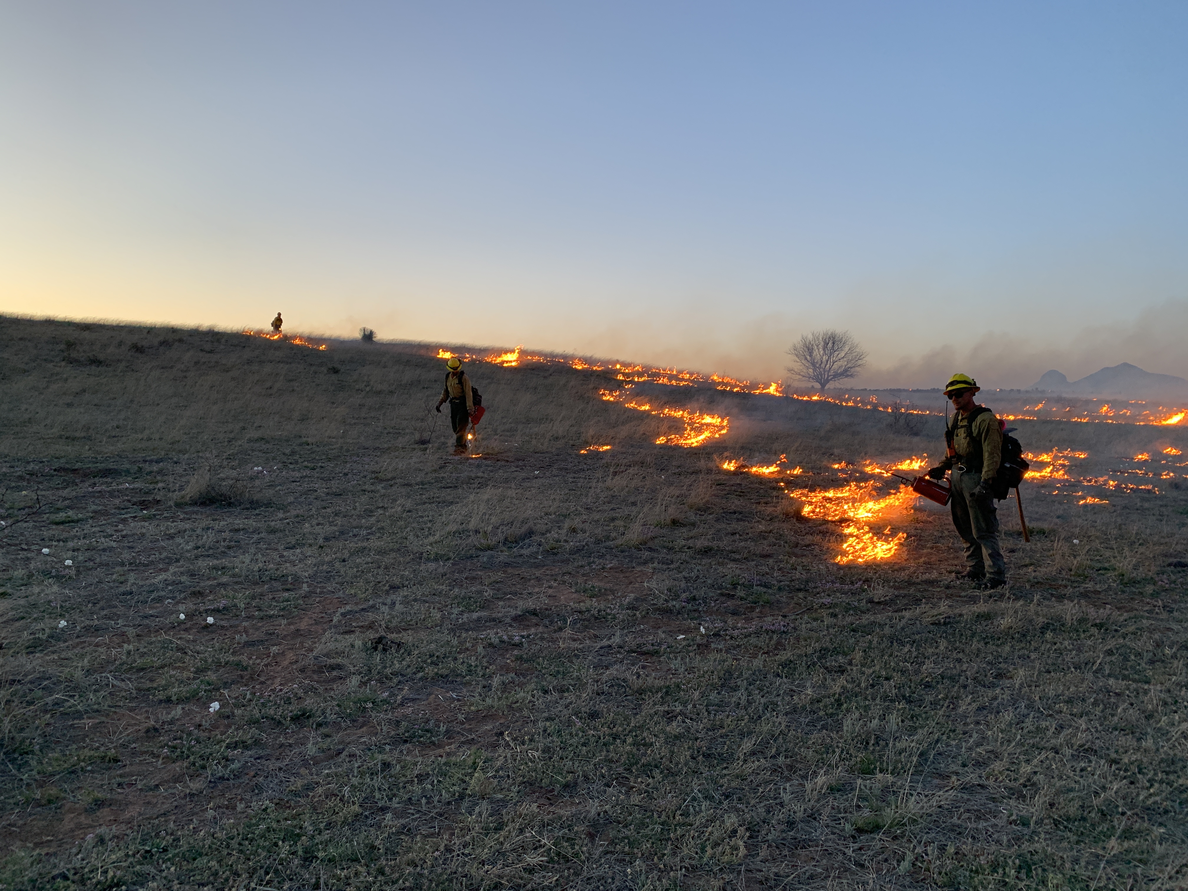
Babacomari Ranch PRESCRIBED BURN Photos
Related Incident: Babacomari Ranch PRESCRIBED BURN
Publication Type: News

Great Lakes Fire Evening Update April 25 2023
Related Incident: Great Lakes
Publication Type: News
Great Lakes Fire Evening Update, April 25, 2023
Join us for an in-person community meeting on the evening of Thursday, April 27th, from 6:00 pm to 7:00 pm. at Creekside Elementary School. The school is located at 2790 Landscape Drive in New Bern. This meeting will also be hosted virtually on Facebook Live at https://fb.me/e/5RLxG0dUj.
Note: There have been an overabundance of offers from the public regarding donations to the fire efforts. We are extremely grateful to the community for the support shown to firefighters. We currently do not have the capacity for processing and storing donations on site. In lieu of donations to the Great Lakes Fire incident, we ask that you consider making a monetary donation to the Wildland Firefighter Foundation.
Great Lakes Fire: The Great Lakes Fire, located within Croatan National Forest, one mile South-Southeast of New Bern, started on April 19th. The cause of the fire is under investigation. It is burning in pocosin swamp and mixed fuels. The fire is burning within the imprint of the 2012 Dad Fire, which burned roughly 21,331 acres. No structures have been lost and none are currently threatened.
Acreage: 32,400 acres Containment: 30%
Personnel and Equipment: 184 total personnel; 4 Helicopters, 15 Type-6 Engines, 22 Type-2 Tractor Plow Units, 1 Fixed Wing Aircraft, and 1 tracked vehicle.
Today: Crews worked today to continue strengthening containment lines and monitoring the fire perimeter for smoke. Reconnaissance flights took place to look for heat signatures within the fire interior. No visible smoke was seen throughout much of the fire imprint with the exception of the fire burning in the organic soils in the southeast portion of the fire. The 8-acre spot fire showed no growth today, and firefighters continued to mop up any smoldering pockets within the interior.
As indicated by Incident Commander Trainee Shane Hardee during the morning briefing, “if we don’t make plans for the ‘what if’ factor, this fire could wake up down the road, so we need to plan and prepare for what could be if the fire conditions change two, three, four weeks from now.”
Weather and Fire Behavior: Sunny skies and drying conditions were predominant today, but no intensification of the wildfire was identified.
“The fire is not currently burning laterally, but vertically down into the soil,” noted Operations Section trainee Shawn Nagle.
Due to the organic nature of pocosin fuels, heat from the fire may not be seen in the form of smoke or flames on the surface but can be picked up from infrared scanning on reconnaissance flights a few feet below the surface of the ground.
Air quality: Information on current air quality data for North Carolina can be found at https://www.airnow.gov/.
Closures: Road closures on County Line Road and Catfish Lake Road remain in effect. Updates to road closures surrounding the fire can be found at https://drivenc.gov/.
Temporary Flight Restriction: A Temporary Flight Restriction (TFR) remains in place over the fire area; information can be found at Federal Aviation Administration website. This is necessary to protect aerial operations. If there are intrusions into the Temporary Flight Restrictions, we must stop aerial operations.
Eldorado National Forest Roadside Hazard Tree Mitigation Project 42523
Related Incident:
Publication Type: News
Roadside Hazard Tree Mitigation Project
Placerville, Calif, April 25, 2023 – The Eldorado National Forest is beginning implementation of their Roadside Hazard Tree Mitigation Project. This project is designed to reduce safety hazards along the 2,461 miles of National Forest System (NFS) roads, including 116 miles of state, local, and private roads in Alpine, Amador, El Dorado, and Placer counties. The project aims to ensure the integrity of the NFS roads and improve safety for the public, Forest Service staff, firefighters, emergency response personnel, law enforcement, private landowners, contractors, special use permit holders, and others.
It is important to address the issue of hazardous trees in the aftermath of high-severity wildfires, as they can pose a significant risk to road users. Trees that have been killed or damaged by a fire, as well as those affected by insects, disease, drought, or other stressors may become unstable and more likely to fall, particularly in high winds or other adverse weather conditions. This project’s goal to identify and remove those hazardous trees within striking distance of roads is a proactive approach to reducing the risk of accidents, injuries, and damage to roads.
The project's scope is to identify, fell, and remove hazardous trees that are at risk of striking a road within a buffer area of 200 feet from the edges of NFS maintenance level 1 through level 5 roads, as well as identified state, county, local, and private roads through NFS lands. However, not all roads within the project area will be treated, and roads within designated wilderness areas are not included in the project scope.
“The Eldorado National Forest’s Roadside Hazard Tree Mitigation Project was designed to increase the resilience of the forest to a range of environmental threats, not just wildfires. By removing hazardous trees that could pose a risk to public safety, and infrastructure, the project aims to reduce the impact of future wildfires and other natural disasters,” said Forest Supervisor, Joseph Stout.
Treatment of lower maintenance level roads will be based on various factors, including administrative needs, permittee needs, access needs for utilities, and other uses. The project will use a variety of methods to remove the hazardous trees within the designated buffer area. These methods may include mechanical removal and piling, hand removal and hand piling, mastication, towed or in-wood chipping, and pile burning.
The project is conducted in phases, and the first phase will focus on 231 miles of roads within the Caldor Fire footprint. This phase of the project is expected to last 2 to 3 years, indicating that it is a significant undertaking. It is important to note that detailed information on each phase of the project will be shared with the public prior to work being started.
Great Lakes Fire Morning Update April 25 2023
Related Incident: Great Lakes
Publication Type: News
Great Lakes Fire Morning Update, April 25, 2023
Acres: 36,000
Cause: Undetermined
Containment: 30%
Total Personnel: 245
Start Date: April 19, 2023
Location: Croatan National Forest
Fuels: Pocosin and mixed pine
Highlights of the Great Lakes Fire: The Great Lakes Fire on the Croatan National Forest started on Wednesday, April 19. Previous prescribed burning by the U. S. Forest Service staff helped slow the fire spread by reducing the amount of burnable vegetation. The reduction in acreage is due to additional reconnaissance flights over the fire.
Federal, state, local, and private resources such as Weyerhaeuser are working together to help contain the fire. Currently, the fire is 2-3 miles from the nearest residential area. We have a new webpage, Inciweb, listed above which provides more information.
Travelers on highways adjacent to the fire area should continue to proceed with caution, especially on highways 17 and 70 where firefighters are operating. Smoke could linger in the area, particularly in the mornings and evenings. With the change in weather today, we anticipate seeing more smoke due to smoldering fires along with warmer and dryer weather.
Personnel and Equipment: 245 total personnel; 1 hand crew; 3 helicopters; 8 engines; 3 Fixed Wing Airplane; 24 Tractor/Plows
Yesterday: Firefighters continued to improve and connect containment lines around the main fire. Crews constructed containment lines around the spot fire located near Brice Creek and continue to mop up remaining smoldering pockets within the interior. Containment lines were reinforced on the west and northwest sides of the fire between Weyerhaeuser timber lands and U.S. Forest Service property. The eastern perimeter of the fire was patrolled with engine equipment and aircraft but no significant heat was found along the boundary. Smoke production was minimal.
Today: Firefighters will continue to connect containment lines around the main fire and around the spot fire. Containment lines will also be reinforced between Weyerhaeuser timber tracts, private timber tracts, and the U. S. Forest Service property. These lines will be a combination of direct and indirect firelines, which will “build a defendable box” around the fire to help both now and in the future. Firefighters and air assets will patrol and monitor any areas which are not showing any fire activity. If winds shift during the day, resources will be relocated as necessary based on needs and weather conditions. Personnel are also working to repair and improve Little Road.
Weather and Fire Behavior: Monday’s weather stayed mostly cloudy with sparse rain scattered throughout the day. Cooler temperatures and light winds supported mild fire behavior, however some areas in the interior continue to smolder. Tuesday’s weather is predicted to be sunny with temperatures near 70 degrees, relative humidity near 30%, and light winds from the Northeast.
Evacuations: No evacuations have been necessary to this point. All evacuations will be ordered by the local Emergency Management/Services Coordinators office.
Road Closures: Portions of Catfish Lake Road and County Line Road remain closed for the safety of travelers and firefighters. All road closures are controlled by local authorities in conjunction with the NC Department of Transportation. Road closures related to the wildfire can be found by searching under Craven County on DriveNC.gov.
Flight Restrictions: A Temporary Flight Restriction (TFR) remains in place over the fire area; information can be found at Federal Aviation Administration website. This is necessary to protect aerial operations. If there are intrusions into the Temporary Flight Restrictions, we must stop aerial operations.
Great Lakes Fire Evening Update April 24 2023
Related Incident: Great Lakes
Publication Type: News
Great Lakes Fire Evening Update, Mon., April 24, 2023
Acres: 32,400
Cause: Under Investigation
Containment: 30%
Total Personnel: 245
Start Date: April 19, 2023
Location: Croatan National Forest
Fuels: Pocosin and mixed pine
Highlights:
The Great Lakes Fire on Croatan National Forest is 32,400 acres in size and 30% contained. More accurate acreage data was obtained based on flight reconnaissance measurements.
Cloud cover and mild weather conditions kept fire behavior to a minimum.
Travelers on highways adjacent to the fire area should continue to proceed with caution, especially on highways 17 and 70 where firefighters are operating. Smoke could linger in the area, particularly in the mornings and evenings. Road closures related to the wildfire can be found by searching under Craven County on DriveNC.gov.
Operations:
Firefighters continued to improve and create additional firelines around the main fire. Crews constructed firelines around the spot fire located near Brice Creek and continue to mop up remaining smoldering pockets within the interior. Firelines were reinforced on the west and northwest sides of the fire between Weyerhaeuser timber lands and U.S. Forest Service property. The eastern perimeter of the fire was patrolled with engine equipment and aircraft but no significant heat was found along the boundary. A Temporary Flight Restriction (TFR) remains in place over the fire area; information can be found at Federal Aviation Administration website.
Weather and Fire Behavior:
Today’s weather stayed mostly cloudy with sparse rain scattered throughout the day. Cooler temperatures and light winds supported mild fire behavior, however some areas in the interior continue to smolder.
Great Lakes Fire Morning Update April 24 2023
Related Incident: Great Lakes
Publication Type: News
Great Lakes Fire Morning Update, Mon., April 24, 2023
Acres: 36,000
Cause: Under Investigation
Containment: 30%
Total Personnel: 245
Start Date: April 19, 2023
Location: Croatan National Forest
Fuels: Pocosin and mixed pine
Highlights:
The Great Lakes Fire on Croatan National Forest remains at 36,000 acres and is 30% contained. The Southern Area Red Team entered into unified command with the North Carolina Forest Service and the U.S. Forest Service yesterday evening.
With the rainfall Saturday and mild weather Sunday, fire activity was reduced yesterday which helped firefighters conduct planned fire break construction.
Travelers on highways adjacent to the fire area should proceed with caution, especially on highways 17 and 70 where firefighters are operating. Expect smoke in the area, particularly in the mornings and evenings. Please be mindful of road closures in the fire area for your safety and the safety of firefighters.
Operations:
Firefighters will continue to improve fireline around the main fire and a spot fire near Brice Creek and will create fireline on the west and northwest of the fire between Weyerhaeuser and U.S. Forest Service property. The eastern perimeter of the fire will be patrolled and monitored with engines and helicopters. There is a Temporary Flight Restriction (TFR) in place over the fire area, information can be found at Federal Aviation Administration website.
Weather and Fire Behavior:
Today’s weather is mostly cloudy with a few sprinkles possible in the morning. High temperatures today will be around 70 degrees with winds out of the North at 5 to 8 mph. There is potential for the fire behavior to increase this afternoon when pockets of clear sky appear.