
Last Daily Little Mesa Fire Update
Related Incident: Little Mesa Fire
Publication Type: Announcement
August 25, 2023 - Last daily update for the Little Mesa Fire, unless fire activity increases significantly. Firefighting personnel remain working on the fire and are prepared for quick response should fire conditions change in upcoming days.
Lookout Fire Morning Update 8252023
Related Incident: Lookout Fire
Publication Type: News
Lookout Fire
August 25, 2023
Morning Update
Size: 15,924 acres
Start Date: August 5, 2023
Cause: Lightning
Containment: 16%
Point of origin: 3 miles North of McKenzie Bridge, OR
Total personnel: 1,066
Resources: 48 engines l 21 crews l 17 bulldozers l 26 water tenders l 11 masticators l 7 helicopters
Current Situation: Gusty winds and hot, dry weather across the region resulted in increased fire behavior on the Lookout Fire on Thursday. Thunderstorms occurred over the area with lightning and no significant rainfall was recorded over the fire area; the fire remained active last night. Friday’s forecast calls for similar conditions with a chance of thunderstorms.
Containment on the fire’s west, southwest and southern flanks will grow as crews mop-up hot spots to reduce the risk of additional fire spread. On the west flank, crews contained a spot fire across Mill Creek Road and searched for additional threats to control lines. Firing operations will progress to the north as favorable wind conditions allow. Ahead of the fire’s northern flanks, crews, tree-fallers and heavy equipment are preparing roads to be used as control lines.
The fire’s northeast flank has backed down to Deer Creek Road, and crews and heavy equipment have contained several small spot fires across the road. UAS (Unmanned Aerial Systems) or drones are flying through the smoke to provide Infrared imaging to locate additional threats to control lines. Drones are also supporting firing operations, especially in areas that are difficult to reach on foot.
On the fire’s southeast flank, crews are utilizing the powerline road above North Bank Road as a control line for burning operations. Residents in this area are seeing an increase in smoke, and firefighters are patrolling around the clock to detect spot fires across the powerline road.
Lightning started a new fire last night near Horse Creek, south of Highway 126. Crews from the Lookout Fire and local resources mobilized to find and contain the four-acre fire. Detection flights will take place this morning to search for new starts in the area of the Lookout Fire.
Two structural protection groups of firefighters are in place to protect homes effected by the fire. Local agency firefighters and law enforcement officers will maintain a presence in evacuated areas. OSFM resources remain available to return to the incident should the need arise.
Evacuation Centers: An evacuation center is in place at Westridge Middle School in Oakridge for evacuees and small pets from the Bedrock and Lookout Fires. A large animal shelter is established at the Lane County Fairgrounds in Eugene.
Evacuations: In Lane County, there is a Level 3 (Go Now) evacuation notice for North Bank Rd., Mona Campground, Lookout Campground, H.J. Andrews Headquarters and the area west of Highway 126 from Scott Rd. north into Linn County.
There is a Level 2 (Be Set) for areas east of the McKenzie Bridge to, and including Drury Ln. north of Hwy. 126, but south of the McKenzie River, areas north of Hwy. 126 west of the .5 mile mark on Mill Creek Rd. to Blue River Reservoir Rd. at the 1501 junction, Areas north of Hwy. 126 east of the .5 mile mark on Mill Creek Rd. to the east end of Taylor Rd., Taylor Rd., The area south of Hwy 126 to the McKenzie River from the east end of McKenzie River Dr. to the McKenzie River Bridge just east of Taylor Rd., Highway 126 from the Highway 242 junction to Scott Road, Paradise Campground, FS Rd. 302, Belknap Hot Springs Rd., the areas east of Hwy. 126 from Scott Rd. north into Linn County.
There is a Level 1 (Be Ready) evacuation notice for areas south of Hwy. 126 from Blue River Reservoir Rd. east to the east end of McKenzie River Dr, McKenzie River Dr. and areas directly to the south and east, The area south of Hwy 126 from the McKenzie River Bridge just east of Taylor Rd. to Scott Creek Rd, Belknap Springs Rd. S, Hwy 242 to FS Rd. 220, Yale Ln, Camp Yale Rd, FS Rd. 2643 southeast to the 445 spur.
For Lane County evacuation updates visit: https://www.lanecountyor.gov/cms/one.aspx?pageId=19729054
In Linn County, there is a Level 3 (Go Now) from Olallie Campground and the Linn County line, north and west of Highway 126, extending north to Ice Cap Campground and Trailhead at Carmen Reservoir, then west to encompass Lakes End Campground and trail system at Smith Reservoir. Tamolitch Falls/Blue Pool is also within this LEVEL 3 (GO NOW) Evacuation Zone
A Level 2 (Be Ready) for the areas of Ice Cap Campground and Trailhead at Carmen Reservoir, north to where Ikenick Creek and Highway 126 intersect, and extending to the east in line with other evacuation boundaries enacted, and west along Highway 126.
Level 1 (Be Ready) evacuation zone for the areas north of where Ikenick Creek and Highway 126 intersect, extending east to the Willamette National Forest boundary, and north in line with Highway 20. This includes all areas around Clear Lake, and Clear Lake Campground, as well as Fish Lake and Campground. For current information please see Linn County’s website at https://www.linnsheriff.org/
Closures: Highway 242, McKenzie Highway, is closed between milepost 61-76, 14 miles west of Sisters, Oregon to just east of the junction with Highway 126. Highway 126 is currently open. Please monitor Trip Check for any updates at: https://tripcheck.com/
Willamette National Forest closures can be found at: https://www.fs.usda.gov/detail/willamette/alerts-notices/?cid=fseprd552029Restrictions: Fire Restrictions are in place on the Willamette National Forest: https://www.fs.usda.gov/willamette
Smoke Outlook: Available at: https://outlooks.wildlandfiresmoke.net/outlook/4c92bc1a?
Information Line: 541-215-6735 8am-8pm | Email: 2023.lookout@firenet.gov
Facebook: https://www.facebook.com/LookoutFire2023
Bear Creek Daily Update August 25 2023
Related Incident: Bear Creek Fire
Publication Type: News
August 25, 2023
Type 3 Team, Incident Commander: Nick Collard ICT3, Grif Cochran ICT3 (T)
Daily Update – 9:00 AM
Highlights: Command of both fires was transferred from the NIMO1 Team to a Type 3 Team at 6:00am today. Conditions today will be very similar to yesterday with mostly cloudy conditions, scattered showers and thunderstorms and moderate relative humidity. Fire activity is expected to be minimal with smoldering, creeping, and backing where pockets of heat remain. Crews and air resources are available to respond quickly if conditions change.
Quartz Ridge Fire: 1799 acres, increase of 136 acres | 70% of objectives achieved | 118 personnel assigned
The southeastern and eastern edges of the fire continue to have pockets of heat with minimal to moderate fire behavior with some backing and movement in steep terrain. The pocket of fire on the east side of Quartz Creek is within a rocky area and constrained by natural features. Direct control lines are being utilized to suppress accessible parts of the fire and indirect control lines are providing confinement on remote areas that present high safety risks to firefighters.
Bear Creek Fire: 415 acres, no change in acreage | 71% of objectives achieved | 23 personnel assigned
The Bear Creek Fire has continued to be inactive with some isolated spots of smoldering. No change in fire behavior is expected with moist conditions. The fire size has remained steady at 415 acres for several days, and no growth is expected over the next few days.
Weather: High temperatures will be from the mid 60s to mid 70s with afternoon minimum relative humidity of 40 to 50%. Light winds of less than 10 mph is forecast. Overnight humidity recovery will be good with relative humidity increasing to 80% or higher.
San Juan National Forest Temporary Area Closures: Closure orders are in effect and additional information can be found at Closure Orders and Maps are available here. Roads and trails within area closures are Quartz Meadows Rd (NFSR#685), Mosca (Piedra) Road (NFS #631), Quartz Ridge Trail (NFST#570), Quartz Creek Trail (NFST#571), Weminuche Trail (NFS #592), Sand Creek Trail (NFS #593), NFS Trail #591, NFS Trail #524, NFS Trail #584; and NFS Trail # 673.
Restrictions: Stage 1 Fire Restrictions are in place for the San Juan National Forest and additional information is available here.
Fire Information
Office Hours: 8:00 AM – 8:00 PM
Phone: 970-426-5370
Quartz Ridge Fire
Email: 2023.QuartzRidge@firenet.gov
InciWeb:
https://inciweb.nwcg.gov/incident-information/cosjf-quartz-ridge-fire
https://www.facebook.com/profile.php?id=100095556640621
Bear Creek Fire
Email: 2023.BearCreek@firenet.gov
Inciweb
https://inciweb.nwcg.gov/incident-information/cosjf-bear-creek-fire
https://www.facebook.com/profile.php?id=100095241777192
Ridge Doris Point Tin Solider Fire Daily Update for August 25 2023
Related Incident:
Publication Type: News
????? ????
Location: 6 miles southeast of Hungry Horse
Size: 3665 acres
Percent Contained: 76%
Cause: Lightning
Start Date: July 30th, 2023 @ 3:45 PM
Personnel Assigned: 472
????? ????? ????
Location: 8 miles south of Hungry Horse
Size: 1585 acres
Percent Contained: 58%
Cause: Lightning
Start Date: July 30th, 2023 @ 3:45 PM
Personnel Assigned: 29
??? ??????? ?????
Location: 17 miles east of Swan Lake
Size: 8165 acres
Percent Contained: 20%
Cause: Lightning
Start Date: July 30th, 2023 @ 3:45 PM
Personnel Assigned: 96
??????????: A line of showers and potential thunderstorms with gusty, erratic winds is expected to pass through the fire area later this afternoon through this evening. A warming and drying trend is predicted through the weekend. Expect to see increased activity on all incidents as weather improves. Southwest Area Incident Management Team 1 will host a community meeting at the Glacier Bible Camp at 5:00 PM on Sunday, August 27th.
??????????:
Ridge Fire: Yesterday resources monitored fire areas they were able to access as some locations were still inaccessible due to the previous rain. Crews are preparing backhaul missions amidst unfavorable road conditions. Aviation resources conducted a backhaul mission to remove the smart tank – a large tank with a remotely activated pump system. Today crews will begin moving the mechanical logging equipment out of the area. Ground resources will also attempt to enter the aforementioned inaccessible locations to evaluate fire conditions and prepare for backhaul. The repair group will continue evaluating restoration needs.
????? ????? ????: Crews monitored the southwest and east sides of the fire perimeter yesterday, as well as evaluated hazard trees along FS RD 895 and mitigated rolling debris around the campground. Today ground resources will continue with that mission with an emphasis on hazard tree removal projects.
??? ??????? ????: Yesterday crews put in good work containing the area of slop over along Meadow Creek and continued prep work along Meadow Creek towards Tin Creek, which included the use of mechanical thinning equipment. Today crews will further their missions from yesterday by monitoring the secured area of slop over for remaining hotspots, continue with mechanical thinning along Meadow Creek, and conduct prep work on FS RD 2628 towards FS RD 2828 near the Hyrdo Dam. Additionally, personnel engaged in point protection will maintain pump operations around structures.
??????? ??? ???? ????????:
A ridge of high pressure continues to build over the region. A line of showers and potential thunderstorms with gusty, erratic winds is expected to pass through the fire location late this afternoon and into this evening. After the passage of this feature, the ridge of high pressure with a warming and drying trend becomes the dominant feature.
?????, ????? ?????, ??? ??? ??????? ?????: 81-86 degrees in the lower elevations and 71-76 degrees in the mid-slopes to ridges with minimum relative humidity at 27-32%. For the Ridge and Doris Point fires, winds will be southeast 5-10 mph with gusts to around 15 mph on the ridgetop. For the Tin Soldier fires, winds will be east-southeast 7-12 mph with gusts around 20 mph on the ridgetop.
????? & ????? ???? ???-?????????? ??????:
The Flathead County Sheriff’s Office has rescinded the pre-evacuation notice from the east side of Spotted Bear Road to West Glacier. Visit the Flathead Sheriff’s office for details https://www.facebook.com/flatheadsheriff
???? ???????:
The Hungry Horse Reservoir is closed to all public access, including both the east and west side roads. The Forest Closure Order that includes the Heinrude Community remains in effect. As firefighting efforts continue on the Ridge Fire, the Tin Soldier, and other fires in the area, the closure is in place to provide for public and firefighter safety. https://www.fs.usda.gov/alerts/flathead/alerts-notices/?aid=82283
?????????? ???????????:
Residents should stay alert for changing conditions and visit ready.gov/wildfires for preparing for wildfires. Please refer to https://inciweb.nwcg.gov/incident-information/mtfnf-tin-soldier-fire for the Tin Soldier Complex Incident information.
???? ???????????: 406-998-6074 (8:00 am to 7:00 pm) ?????: 2023.ridge@firenet.gov
https://www.facebook.com/ridge.fire.information https://www.youtube.com/@2023ridgefire
Quartz Ridge Daily Update August 25 2023
Related Incident: Quartz Ridge Fire
Publication Type: News
August 25, 2023
Type 3 Team, Incident Commander: Nick Collard ICT3, Grif Cochran ICT3 (T)
Daily Update – 9:00 AM
Highlights: Command of both fires was transferred from the NIMO1 Team to a Type 3 Team at 6:00am today. Conditions today will be very similar to yesterday with mostly cloudy conditions, scattered showers and thunderstorms and moderate relative humidity. Fire activity is expected to be minimal with smoldering, creeping, and backing where pockets of heat remain. Crews and air resources are available to respond quickly if conditions change.
Quartz Ridge Fire: 1799 acres, increase of 136 acres | 70% of objectives achieved | 118 personnel assigned
The southeastern and eastern edges of the fire continue to have pockets of heat with minimal to moderate fire behavior with some backing and movement in steep terrain. The pocket of fire on the east side of Quartz Creek is within a rocky area and constrained by natural features. Direct control lines are being utilized to suppress accessible parts of the fire and indirect control lines are providing confinement on remote areas that present high safety risks to firefighters.
Bear Creek Fire: 415 acres, no change in acreage | 71% of objectives achieved | 23 personnel assigned
The Bear Creek Fire has continued to be inactive with some isolated spots of smoldering. No change in fire behavior is expected with moist conditions. The fire size has remained steady at 415 acres for several days, and no growth is expected over the next few days.
Weather: High temperatures will be from the mid 60s to mid 70s with afternoon minimum relative humidity of 40 to 50%. Light winds of less than 10 mph is forecast. Overnight humidity recovery will be good with relative humidity increasing to 80% or higher.
San Juan National Forest Temporary Area Closures: Closure orders are in effect and additional information can be found at Closure Orders and Maps are available here. Roads and trails within area closures are Quartz Meadows Rd (NFSR#685), Mosca (Piedra) Road (NFS #631), Quartz Ridge Trail (NFST#570), Quartz Creek Trail (NFST#571), Weminuche Trail (NFS #592), Sand Creek Trail (NFS #593), NFS Trail #591, NFS Trail #524, NFS Trail #584; and NFS Trail # 673.
Restrictions: Stage 1 Fire Restrictions are in place for the San Juan National Forest and additional information is available here.
Fire Information
Office Hours: 8:00 AM – 8:00 PM
Phone: 970-426-5370
Quartz Ridge Fire
Email: 2023.QuartzRidge@firenet.gov
InciWeb:
https://inciweb.nwcg.gov/incident-information/cosjf-quartz-ridge-fire
https://www.facebook.com/profile.php?id=100095556640621
Bear Creek Fire
Email: 2023.BearCreek@firenet.gov
Inciweb
https://inciweb.nwcg.gov/incident-information/cosjf-bear-creek-fire
Little Mesa Fire Update August 25 2023
Related Incident: Little Mesa Fire
Publication Type: News
Little Mesa Fire Update
Friday, August 25, 2023
Location: Approx. 15 miles west, southwest of Delta, CO, Dominguez Escalante National Conservation Area
Discovered: July 31, 2023, 11:00 AM
Cause: Lightning
Estimated Size: 4,009 acres
Vegetation Type: Pinyon, Juniper, sagebrush, grass
Containment: 40%
Total Personnel: 25
Special Note: This will be the last daily update for the Little Mesa Fire, unless fire activity increases significantly. Firefighting personnel remain working on the fire and are prepared for quick response should fire conditions change in upcoming days.
Current Situation: Minimal fire activity was observed yesterday from recent rain; still, subsurface pockets of heat, stumps, and logs within the perimeter will continue to smolder until larger amounts of precipitation extinguish them or they burn themselves out. Firefighters continued to patrol and secure the fire edge while monitoring vegetation conditions for an opportunity to burn the southern lines along Black Point Road and Dry Mesa Road. However, the proper conditions never presented themselves; it was too humid and damp. Yesterday afternoon, light to moderate rain moved over the fire area and continued throughout the night.
In the forthcoming days, fire resources will continue to patrol the perimeter and be vigilant of changing fire conditions as the area begins to dry out next week. Firefighters will observe conditions looking for opportunities to burn the southern lines along Black Point Road and Dry Mesa Road to remove unburned vegetation between the fire perimeter and roads. Completing this burn and reducing available vegetation will tie the fire perimeter into the roads and assure that the fire will not cross the roads.
Weather: Widespread isolated showers and thunderstorms are forecasted in the morning increasing to a 50% chance of wetting rain by afternoon. The area could receive up to one half to one inch of rain. Temperatures will be in the 70’s with south winds 5 mph switching to west in the afternoon. Gusty and erratic winds are expected near thunderstorms in the afternoon.
Evacuations and Closures: No evacuations have been issued. Temporary road closures are in place in Delta County on Dry Mesa Road at the intersection with Escalante Rim Road and on USFS Dry Mesa Road at Sawmill Mesa Road junction. The GMUG National Forests issued a forest closure order for the area around the Little Mesa Fire. Public access to the closure area is limited. Visit https://bit.ly/3YwXNz0 for more information.
Smoke: Smoke is visible from surrounding areas and highways 50, 550, 92, 65, 141 and C37 Road. Go to fire.airnow.gov or colorado.gov/airquality/ to get updates on smoke conditions.
Aviation Safety: Incident aircraft may be flying over the Little Mesa Fire air space. Fire aviation resources are flying at different altitudes and speeds. Unmanned aircraft systems (UAS) or drones must never fly near wildfires. Remember if you fly, we can’t!
For updated information follow on these outlets:
Inciweb: https://inciweb.wildfire.gov/incident-information/coupd-little-mesa-fire
Facebook: @LittleMesaFire Twitter: @SWD_Fire
McKinney Fire Information Update 08252023
Related Incident: McKinney Fire
Publication Type: News
McKinney Fire Information Update –
Start date – 08/20/2023 Size – 39 Acres Containment – 10%
Firefighters working to suppress the McKinney Fire
Santa Fe, NM (8/25/23) – The 40-acre Mckinney Fire started August, 20, within 15 miles North of Jemez Spring, NM. The fire is burning in remote terrain and due to its location, fire managers are developing a plan to manage the fire in a full suppression Strategy, by creating containment lines utilizing hand crews.
Containment efforts on the East flank have been a challenge due to steep and inaccessible terrain.
Fire is burning in the area with no fire history or fuels treatment. As with all incidents, firefighter and public safety remains the highest priority over all other incident objectives. While managing this incident, resources are expected to utilize deliberate risk management processes to ensure they are committed to successful operations under conditions where important values at risk are protected with the least exposure necessary.
A strategic plan is in place to ensure resources limit activities that may disturb eco-sensitive areas, sensitive cultural sites, along with threatened and endangered species and their habitats. Fire personnel are taking proactive measures during any fire management activities to protect water quality.
Precipitation over the fire yesterday for a brief period. Thunderstorms also development across the fire area with potential for downdrafts and lightning is a concern.
Smoke may be more or less visible in the area as active smoldering takes place. Variations in temperatures, humidity & fire activity will impact smoke conditions in the coming days. Smoke-sensitive individuals and people with respiratory problems or heart disease are encouraged to take precautionary measures.
Fire Information –
Inciweb: https://inciweb.nwcg.gov/incident-information/nmsnf-mckinney-fire
New Mexico Fire Information: https://nmfireinfo.com/
Air quality information is available at https://www.airnow.gov/
Black Feather Fire Daily Update August 25 2023
Related Incident: Black Feather Fire
Publication Type: News
![]() Friday, August 25, 2023
Friday, August 25, 2023
Line Construction and Rehab work continues on The Black Feather Fire
Acres: 2,198 acres
Start Date: August 5, 2023
Cause: Lightning
Fuels: Timber, Brush, Understory
Containment: 28%
Resources: 139 personnel
Location: Approximately 9 miles south of Gallina, NM, on the Santa Fe National Forest, Coyote Ranger District. Near the Peñas Negras Trail in the San Pedro Parks Wilderness.
Hand crews gained more progress in the wilderness in continuing and securing the fires edge. Engine crews outside of the wilderness have been patrolling and monitoring the fires edge along with securing any hotspots or smoke showing within the fires perimeter.
Operations: Suppression efforts are continuing within the wilderness and along the Eastern edge of the fire. With heavy dead and down logs and duff layers, fire will continue to smolder. Crews and engines are actively suppressing and monitoring activities in relation to weather and fire behavior to ensure incident objectives are met while remaining focused on firefighter safety.
Safety: Equipment and fire crews are actively moving in and around the fire area. Please use caution when traveling around the Black Feather Fire. The Temporary Flight Restriction is still in place. Please do not fly drones anywhere near the fire. If you fly, we can’t fly.
Weather: Plentiful moister will continue the potential for wetting showers and thunderstorms Thursday through Friday. Cell motions will be mainly from south to north Thursday then trend from southwest to the northeast Thursday night and Friday, but will be slower moving on Friday. Excellent overnight humidity recovery. Slight warming and drying trend from Thursday and Friday.
Restrictions/Closures: Effective Monday, August 21, the Santa Fe National Forest has issued an updated area, road, and trail closure in part of the Coyote Ranger District. See https://bit.ly/BlackFeatherClosureUpdate for information and a corresponding map. Forest Road 103 is now open. Closures will be adjusted based on fire activity.
Smoke: Variations in temperatures, humidity & fire activity will impact smoke conditions in the coming days and weeks. Smoke may be visible in the area as active smoldering takes place. Smoke-sensitive individuals and people with respiratory problems or heart disease are encouraged to take precautionary measures. Air quality information is available at https://www.airnow.gov/.
Evacuations: The communities of Mesa Pinabetal, Mesa Poleo, and Wetherill remain in ‘Ready’ status. The Coyote Senior Center is open to evacuees, and livestock can be taken to the Rio Arriba Rural Event Center near Abiquiu. The Rio Arriba County Sheriff’s Office will coordinate evacuations if they go into effect. For more information, use the QR code below and visit the Sheriff’s Office Facebook page: https://www.facebook.com/profile.php?id=100079688263048.
Fire Information: 505-460-0499 – 2023.blackfeather@firenet.gov
InciWeb: https://inciweb.nwcg.gov/incident-information/nmsnf-black-feather-fire
Facebook: https://www.facebook.com/blackfeatherfireinfo
New Mexico Fire Information: https://nmfireinfo.com/
Shearwood Creek Fire Daily Update August 25 2023
Related Incident:
Publication Type: News
Shearwood Creek Fire Daily Update
August 25, 2023
11:00 am
Size: 3,000 acres
Containment: 50%
Start Date: August 24, 2023
Cause: Under Investigation
At 12:16 pm on Aug. 24th, Texas A&M Forest Service received a request for assistance for a fire on County Road (CO) 032 off State Highway 63, approximately 15 miles northwest of Jasper, Texas. The fire is actively burning in mixed oak/pine timber with grass and yaupon understory.
In coordination with local fire departments, crews from Texas A&M Forest Service and USDA Forest Service Forest as well as several aviation resources are engaged in suppression efforts. Multiple dozers are working to construct containment lines on the fire and have made progress on the eastern western sides of the fire. Before the wind shift, when the fire was still moving southwest, it did spot over the Neches River, and crews moved to the south side to create containment line. The fire started to experience winds from the southwest around nightfall, and it continued forward progression on the northwest side.
During daylight hours on the first day, two Type 1 helicopters and 2 super scoopers worked to slow forward progression and provide structure protection. Multiple aviation resources (Air Attack, 4 Fire Boss aircraft, 2 Type 1 Helicopters) are back on scene this morning to continue suppression efforts.
A Temporary Flight Restriction (TFR) has been ordered for the area over the fire, [NOTAM: FDC 3/1024, https://tfr.faa.gov/save_pages/detail_3_1287.html]. Please avoid the area to provide a safe environment for incoming firefighting aircraft.
Weather:
Hot and relatively dry conditions will continue today. The relative humidity is expected to rise to 30-40 % from yesterday's isolated showers and thunderstorms. Those isolated storms will continue today, and wind speeds will increase to 10-15 mph out of the southwest this afternoon.
Evacuations:
Evacuations for the following County Roads have been ordered. County Roads: 032-034, 037, 39. Red Cross has opened a shelter for evacuees at the Ebenezer Baptist Church at 1277 Co Rd. 44, Jasper, Texas. An assistance center will open this morning at Harvest Church at 8:00 am.
Closures:
Portions of State Highway 63 were closed earlier today but have been opened. Recreational Road 225W remains closed from SH 63 to the Neches River in both directions, and is expected to remain closed until 12:30 pm this afternoon. Additional information on road closures in the area can be found on www.drivetexas.org.
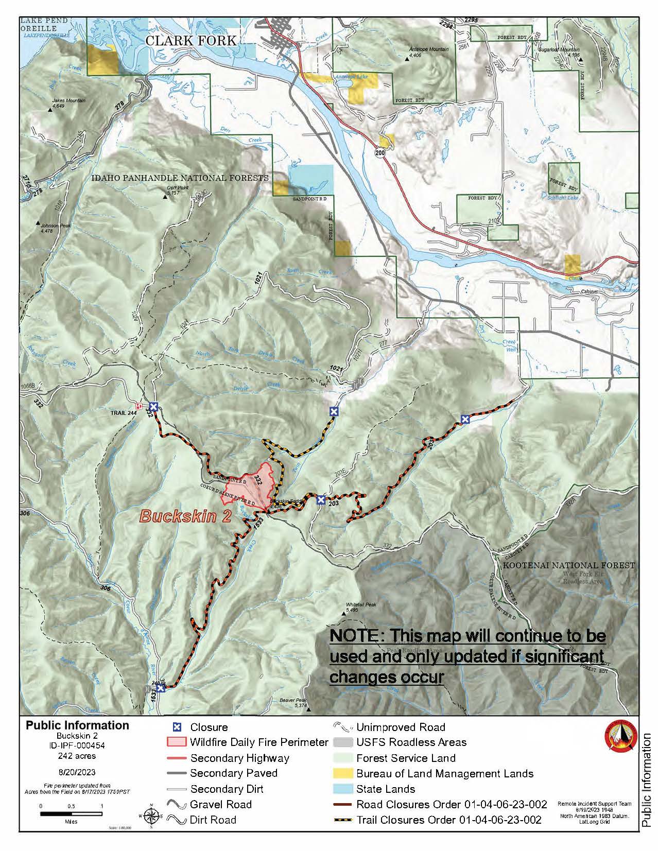
Buckskin 2 Daily Update August 25 2023
Related Incident:
Publication Type: News
Buckskin 2 Fire - August 25, 2023
Idaho Panhandle National Forests, Sandpoint Ranger District Fire Information: 208-557-8813
https://inciweb.nwcg.gov/incident-information/idipf-buckskin-2-fire
Type 3 Incident Commander, Brian Hicks
Location: Located approximately 8 miles due south of Clark Fork, ID on the upper end of Twin Creek and Buckskin Saddle, south of Highway 200
Start Date: 8/4/2023 Cause: Undetermined Size: 242 acres Containment: 85%
Total Personnel: 68 Engines: 1 Hand Crews: 2 Modules: 2
Heavy Equipment: 1 Water Tender
There continues to be no growth on the fire in several days, and the fire behavior is just a smoldering interior allowing crews and equipment to improve the direct line along the west flank of the fire. Given the fire’s low activity and lack of growth, the fire team will be given back to district authority and moved to an IC4 beginning Saturday August 26, 2023.
The fire is still 1.8 miles from the nearest structure, and the Forest Closure remains in place for fire firefighters and public safety around active operations.
Until a season-ending event occurs, smoke may be visible from pockets of unburned fuels within the perimeter of the fire. The smoke that has settled into the area is from existing and new large fires in Washington and British Columbia. See https://fire.airnow.gov/ for more detailed smoke information.
The published email and phone number will still be monitored. If you are having any issues connecting to these sites, or simply have questions about the status of the fire, please call the fire information line at 208-557-8813. The line is staffed from 7 AM to 7 PM, and all calls will be returned.
EVACUATION STATUS
The Bonner County Sheriff’s Office has rescinded the READY notification for the Twin Creek Rd and Rearden Rd residents in Clark Fork as of August 19, 2023, at 4 PM. Citizens should continue to stay alert and prepared, as fire conditions are always subject to quick and unexpected changes. Sign up for Bonner County Sheriff’s Office emergency messaging through NIXLE at www.nixle.com to receive local status updates.
CLOSURES AND SPECIAL MESSAGES
Forest Closure Order is in effect for roads associated with the Buckskin Fire; the intersection of Forest Service Roads 203 and 332, the intersection of FSR 1021 and 332, and 1533 and 306 in Clark Fork. UTV trail 77 is closed as well. An extension of the FSR 203 closure, extending to the edge of private land, took effect on 8/15 at 0700. The public is prohibited from the general area for firefighter safety and asked to practice caution while driving near firefighters and apparatuses.
Stage II Fire Restrictions are in effect. To view the Idaho Fire Restrictions Plan and a statewide map with current information regarding fire restrictions, please visit https://www.idl.idaho.gov/fire-management/fire-restrictions-finder.
The Temporary Flight Restriction that was in place for the safety of our aerial resources and firefighters on the ground has been officially rescinded as of August 20, 2023. Drone operators are reminded to never fly around active fire operations, as it could create critical interference with firefighting efforts. If you fly, we can't!
WEATHER
Sunny, with a high near 80. West wind around 7 mph.