
Evacuations Lifted
Related Incident: El Valle Fire
Publication Type: Announcement
All evacuation statuses were lifted at 10:30 a.m. on Sep. 13
Valentine Fire Update 99
Related Incident:
Publication Type: News
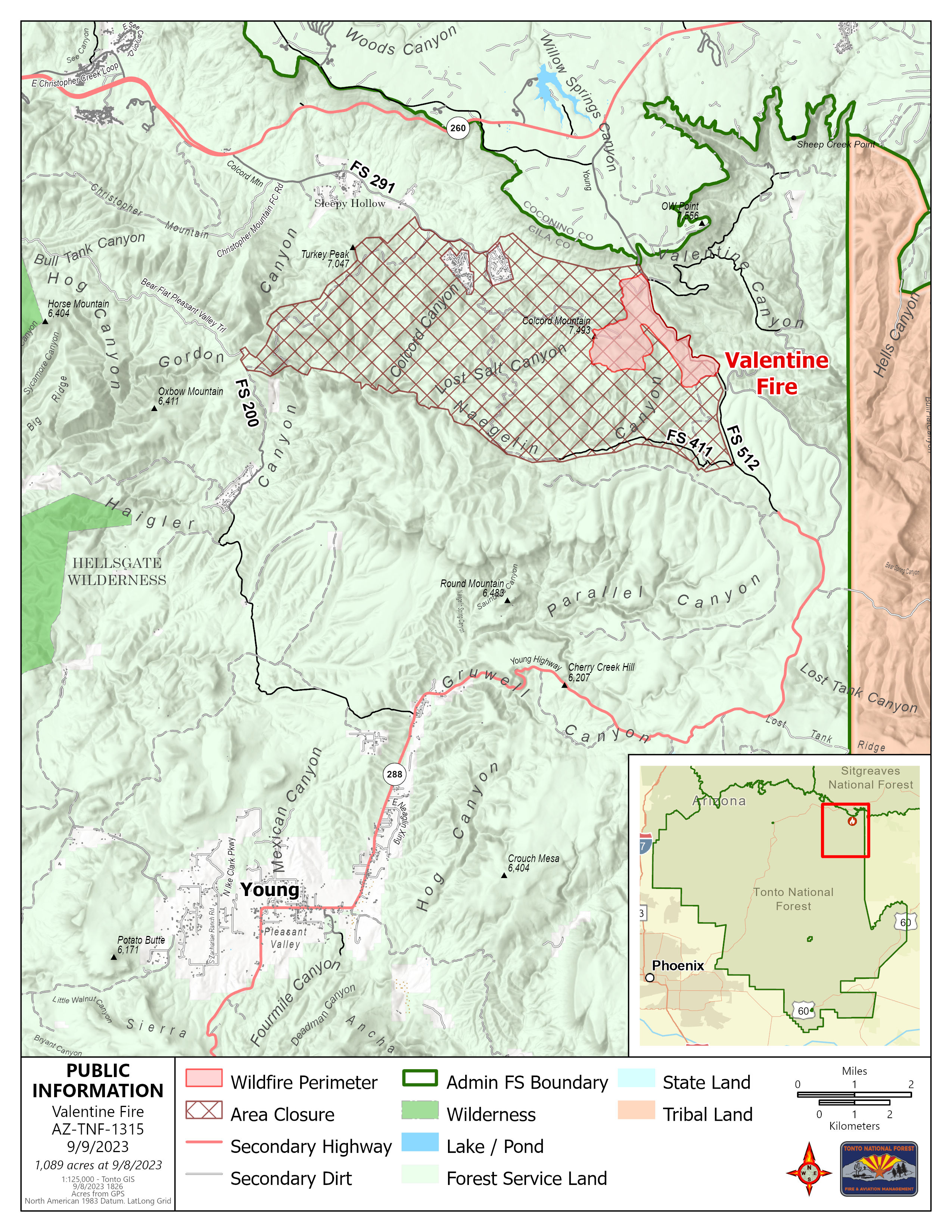
Valentine Fire Update
Saturday, September 9, 2023
Size: 1089 acres
Start Date: August 16, 2023
Cause: Lightning
Completion: 35%
Total personnel: 200
Location: 11 miles northeast of Young, Arizona and 27 miles east of Payson, Arizona
Fuels: Ponderosa Pine, Hardwood litter and timber
Highlights: Gila County Sheriff’s Office announced yesterday that the communities of Ponderosa Estates and Colcord Estates have been placed into SET status. This decision was made by Forest Officials, the Fire Management Team, and Gila County Sheriff’s Office for residents’ safety, due to the proximity of the containment line and firing operation to the communities. For real time evacuation notifications from Gila County Emergency Management via cellular phone, landline phone and/or email, please visit: https://gilacountyaz.genasys.com/portal/en-
Operations: Yesterday, crews held existing containment lines, monitored, and completed some firing operations below the 291 powerline access road during the day shift. A night shift was established due to favorable wind conditions and included firing operations west along the 291 road. Today, crews will continue to hold lines, monitor, and make contingency plans for the northwest fire perimeter.
Fire Ecology: Fuels are an important component of fire ecology because what they are, and when and how they burn, is what determines the effects of a fire. When ponderosa pine has burned frequently, the fire behavior is moderate to low, with some small groups of trees or individuals ‘torching’ occasionally, but most of the fire would be a surface fire that burns through grass and surface litter. Such fires kept fuel from building up by converting it to smoke, ash, charcoal, and other substances which are beneficial to the environment. They also kept the potential fire behavior and effects at levels that were both manageable and beneficial. In many areas, the Valentine Fire is a ‘first entry’ fire, and will significantly decrease the potential fire behavior and the severity of subsequent fires for many years.
Weather: Yesterday, Cloud cover and light precipitation to the west helped raise humidity in the fire area, however, it is expected to remain dry throughout the weekend. Some precipitation and thunderstorms may form along the rim again today but wetting rains are not expected in the area until early next week.
Closures: An emergency closure order for the Valentine Fire has gone into effect as of 6 a.m. Sept. 5, 2023. The public is asked to avoid the fire area. The purpose of the closure order is to protect public health and safety during the Valentine Fire, and to protect assigned firefighting personnel engaging in wildland firefighting operations. Signs and gates will be in place to remind the public not to enter the fire area. Please visit the Alerts and Notices page for more information. https://www.fs.usda.gov/alerts/tonto/alerts-notices.
Safety: The health and safety of firefighters, and the public are always the highest priority. Members of the public are asked to avoid the fire area.
Smoke: The fire will produce considerable amount of smoke due excessive fuel accumulation. Smoke from the Valentine Fire may be visible in the surrounding areas for many days. Smoke-sensitive individuals and people with respiratory problems or heart disease are encouraged to take precautionary measures an interactive smoke map at https://www.airnow.gov/wildfires/ allows you to zoom into your area to see the latest smoke conditions.
Information Links and Contacts:
Tonto National Forest https://www.fs.usda.gov/main/tonto/fire
InciWeb https://inciweb.nwcg.gov/incident-information/aztnf-valentine-fire
Fire Email 2023.valentine@firenet.gov
Fire Information Line (928)-421-4579 • Office Hours: 8:00 AM – 8:00PM
Thut Hill Daily Update 9923 1000 AM
Related Incident:
Publication Type: News
Thut Hill Fire
Acres: 1,295
Containment: 65%
Cause: Unknown
Yesterday, 9/8/23, crews on the Thut Hill fire were able to make good progress. forward progression of the fire was stopped and firelines that were constructed held throughout the night. All road closures and evacuations related to the fire since been lifted.
For today, 9/9/23, crews returned to the fire this morning and began work. plans for today were to patrol and mop up (extinguishing any residual heats found) around the entirety of the fire. Little to no heats have been observed this morning.
Three unoccupied homes were lost in the first period of the fire. no injuries have occurred.
Lions Camp Fire Smoke Report 09092023
Related Incident: Lions Camp Road Fire
Publication Type: News
Smoke Outlook for Lions Camp Road Fire September 9, 2023
Special Statement
Smoke contains microscopic solids and liquid droplets that are so small that they can cause serious health problems. Of these, particles less than 2.5 micrometers in diameter, also known as PM2.5, pose the greatest risk to health. This Smoke Outlook reflects 24-hour PM2.5 impacts on air quality.
Fire
The four fires in the area are Tiger Island (31,083 ac); Elizabeth (930 ac); Hwy. 113 (7,124 ac) and Lions Camp Rd. (787 ac). Fuels have dried after the recent rains and moderate fire activity is expected in the afternoon. (visit Inciweb Tiger Island Fire for more details) (visit Inciweb Hwy 113 Fire for more details) (visit Inciweb Elizabeth Fire for more details) (visit Inciweb Lions Camp Road Fire for more details)
Smoke
Increasing smoke today due to smoke from Canada wildfires moving as far south as the Gulf of Mexico. From local fires expect light smoke in the vicinity of large fuels that continue to smolder. Heat scorched leaves and pine needles have fallen and covered much of the burned areas. Reburn has been occurring within the fire perimeters when fallen leaves are ignited by smoldering fuels. This causes increased levels of smoke for short periods. Even with the reburn occurring, expect to see only light smoke in the immediate vicinity of a fire or on interior roads. None of the communities in the area should be impacted by smoke from local fires. Communities should experience MODERATE air quality today with periods of USG. The Canada wildfire smoke is the main reason for this decrease in air quality from the GOOD we had yesterday to MODERATE.
Daily Fire Update September 9th
Related Incident: Quartz Ridge Fire
Publication Type: News
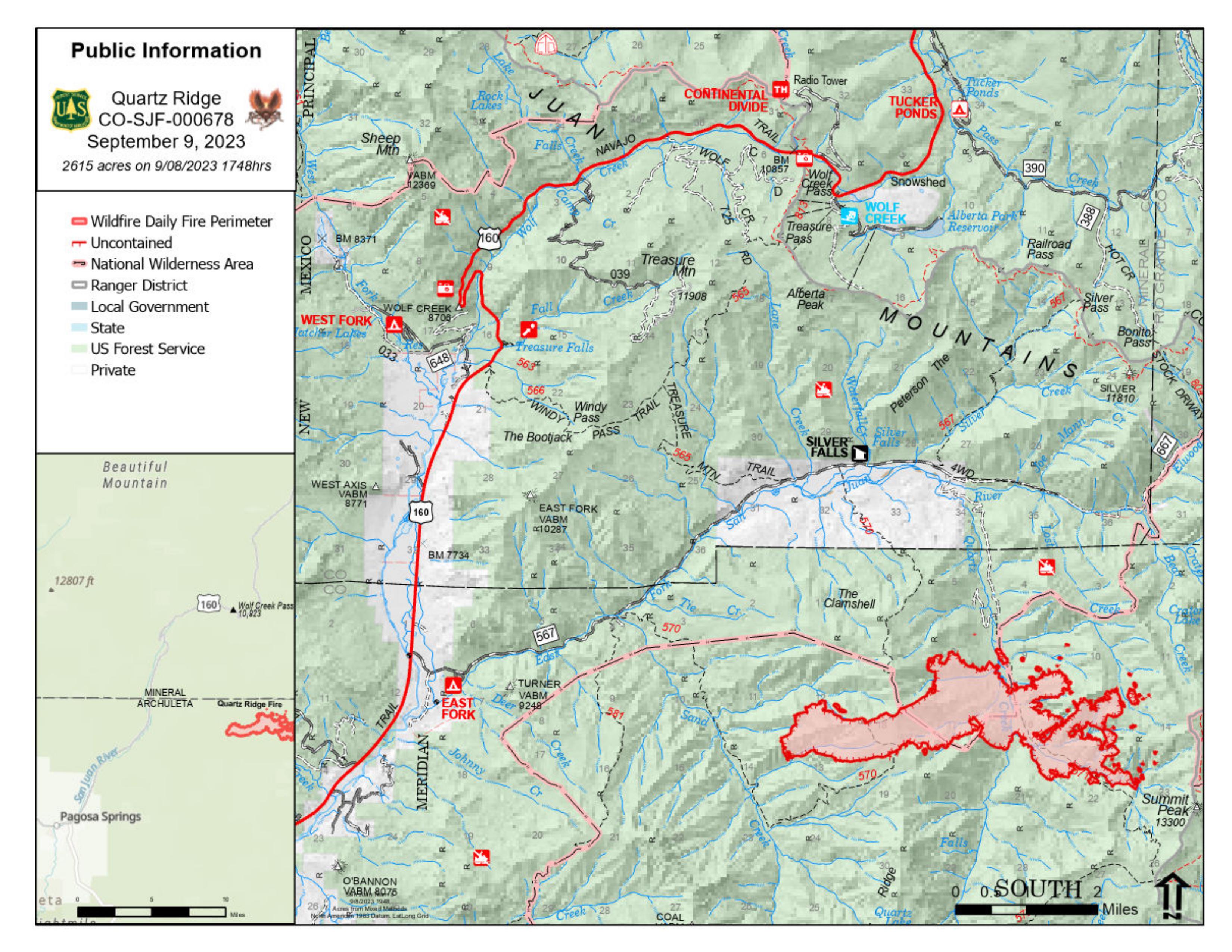
QUARTZ RIDGE FIRE
September 9, 2023 Type 3 Team, Incident Commander: Nate Hallam
Daily Update – 9:00 AM
Highlights: Yesterday both fires had moderate to low fire growth and smoke activity. Although very dry, yesterday’s winds were not as strong, which made large fire growth unfavorable. High pressures will begin to gradually break down today, bringing a cooler trend and possible erratic winds into today’s operational period (9/9).
Quartz Ridge Fire: 2,615 acres, increase of 155 acreages | 77% of objectives achieved | 66 personnel assigned
The Quartz Ridge Fire saw an increase of activity with a total increase of 155 acres. There are few areas within the fire where resources can successfully respond due to the hazards and risks presented to firefighters, including dead and downed trees, snags, and steep terrain. The east side of the fire is the main body where it is burning the hottest. Crews are identifying opportunities for suppression in advantageous areas where firefighters have a high probability of success.
San Juan National Forest Temporary Closures: Closure orders are in effect and additional information can be found here: Quartz Ridge Closure and Bear Creek Closure. Roads and trails within the Quartz Fire area are Quartz Meadows Rd (NFSR#684), Quartz Ridge Trail (NFST#570), Quartz Creek Trail (NFST#571).
Fire Information
Office Hours: 8:00 AM – 8:00 PM Phone: 970-426-5370
Quartz Ridge Fire
Email: 2023.QuartzRidge@firenet.gov
Hwy 113 Fire Smoke Report 09092023
Related Incident:
Publication Type: News
Hwy 113 Fire Smoke Outlook September 9, 2023
Special Statement
Smoke contains microscopic solids and liquid droplets that are so small that they can cause serious health problems. Of these, particles less than 2.5 micrometers in diameter, also known as PM2.5, pose the greatest risk to health. This Smoke Outlook reflects 24-hour PM2.5 impacts on air quality.
Fire
The four fires in the area are Tiger Island (31,083 ac); Elizabeth (930 ac); Hwy. 113 (7,124 ac) and Lions Camp Rd. (787 ac). Fuels have dried after the recent rains and moderate fire activity is expected in the afternoon. (visit Inciweb Tiger Island Fire for more details) (visit Inciweb Hwy 113 Fire for more details) (visit Inciweb Elizabeth Fire for more details) (visit Inciweb Lions Camp Road Fire for more details)
Smoke
Increasing smoke today due to smoke from Canada wildfires moving as far south as the Gulf of Mexico. From local fires expect light smoke in the vicinity of large fuels that continue to smolder. Heat scorched leaves and pine needles have fallen and covered much of the burned areas. Reburn has been occurring within the fire perimeters when fallen leaves are ignited by smoldering fuels. This causes increased levels of smoke for short periods. Even with the reburn occurring, expect to see only light smoke in the immediate vicinity of a fire or on interior roads. None of the communities in the area should be impacted by smoke from local fires. Communities should experience MODERATE air quality today with periods of USG. The Canada wildfire smoke is the main reason for this decrease in air quality from the GOOD we had yesterday to MODERATE.
Daily Fire Update September 9th
Related Incident: Bear Creek Fire
Publication Type: News
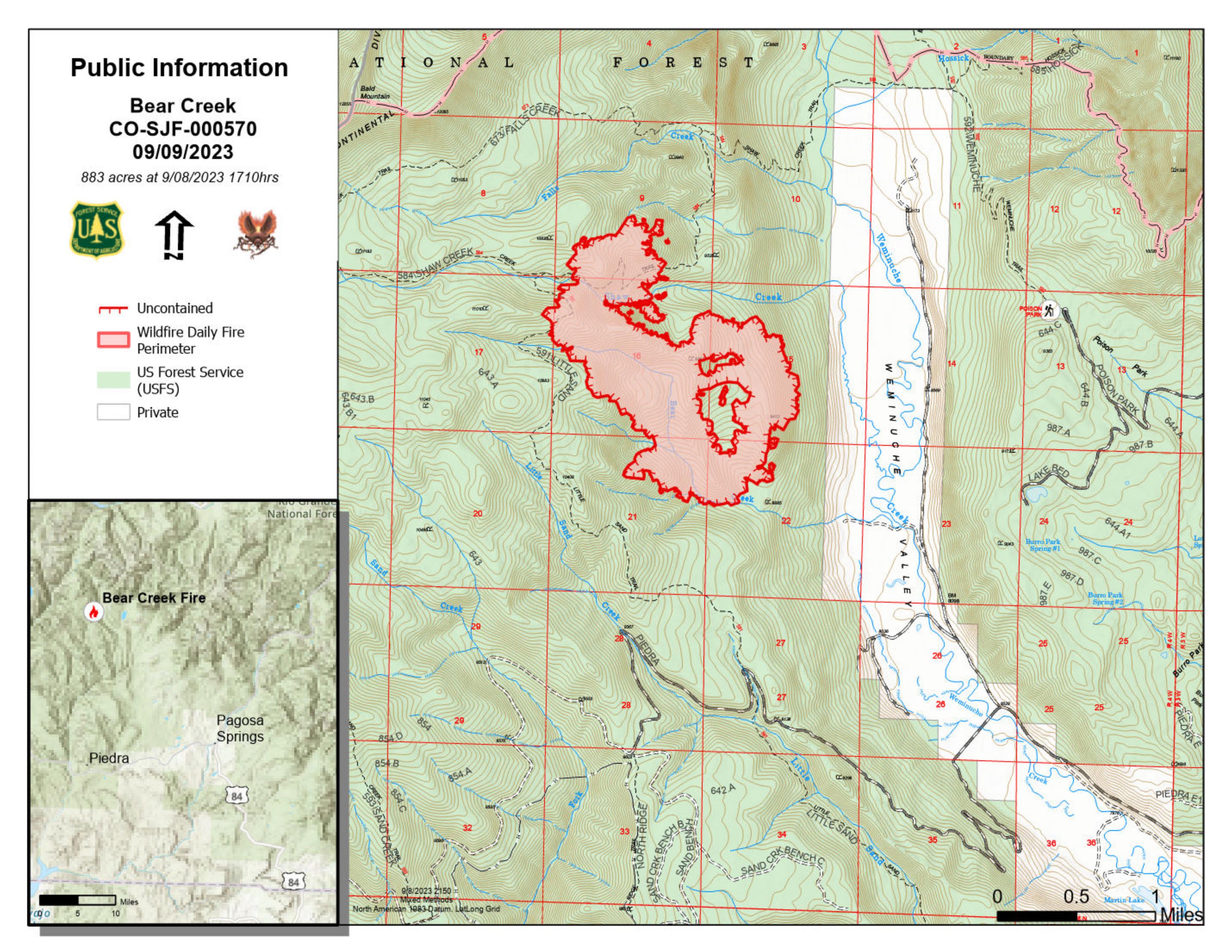
BEAR CREEK FIRE
September 9, 2023 Type 3 Team, Incident Commander: Nate Hallam
Daily Update – 9:00 AM
Highlights: Yesterday both fires had moderate to low fire growth and smoke activity. Although very dry, yesterday’s winds were not as strong, which made large fire growth unfavorable. High pressures will begin to gradually break down today, bringing a cooler trend and possible erratic winds into today’s operational period (9/9).
Bear Creek Fire: 883 acres, increase of 40 acreages | 83% of objectives achieved | 61 personnel assigned
The Bear Creek Fire saw an increase in size of 40 acres. Yesterday, personnel bolstered placement of fire hose, pumps, and portable water tanks for structure protection operations in the Weminuche Valley. Responders will continue to assess, protect, and mitigate hazards to values at risk within the valley. Additionally, opportunities for utilizing natural control features, such as the Weminuche Creek will be evaluated. Control features to the south of the fire have been improved with heavy equipment.
Weather: Last night there were light winds with a maximum humidity around 30%. Later afternoon today and tomorrow, we will begin to see cooler/wetter trends with slight chances of showers, though the incidence of virga is very possible. Chances of rain will increase through the weekend and the beginning of next week. As storms will continue to be scattered by nature both fires may not see wetting rain. The precipitation will not be distributed equally across the San Juan National Forest.
San Juan National Forest Temporary Closures: Closure orders are in effect and additional information can be found here: Quartz Ridge Closure and Bear Creek Closure. The trails within the Bear Creek Fire area are Little Sand Trail (NFST #591) and Shaw Creek Trail (NFST#584).
Fire Information
Office Hours: 8:00 AM – 8:00 PM Phone: 970-426-5370
Bear Creek Fire
Email: 2023.BearCreek@firenet.gov
Flat Fire and Anvil Fire Morning Update 09092023
Related Incident: Flat FireAnvil Fire
Publication Type: News
Anvil Fire Activity
Size: 348 acres Start Date: August 25, 2023 Point of origin: 8 miles east of Port Orford, OR
Containment: 0% Total personnel: 248
Resources: 5 crews, 3 helicopters, 4 engines, 4 water tenders, 4 pieces of heavy equipment
Eight helicopters worked the Anvil Fire yesterday, dropping 196,955 gallons of water. While fire behavior increased due to lower humidity levels, the efforts from the aircraft are currently helping keep the fire north of Red Cedar Creek, east of Anvil Creek, and south of a Dry Creek tributary. These actions help slow fire spread and buy firefighters time to build control lines further away that will have a higher probability of success if the fire grows. Terrain along the active edge of the fire is exceptionally steep, dangerous and unsafe for crews to fight the fire directly. Wildland Fire Modules are assessing weather and fuel conditions around the fire. They determined fuel moisture levels in the drainage bottoms are higher than on the ridgelines, which may also be helping to slow fire spread.
Several Interagency Hotshot Crews are working, along with masticator operators, to clear vegetation 30 feet off each side of Grassy Knob Road so it can be used as a control line if needed. Approximately one mile west of the fire, dozer operators and the Hotshot crews are constructing fireline from Grassy Knob Road south towards the fish hatchery on Elk River Road. This line will tie in with the handline dug behind the hatchery. Two structure protection groups are working at residences along Elk River Road and Sixes River Road.
Flat Fire Activity
Size: 34,242 acres Start Date: July 15, 2023 Point of origin: 2 miles southeast of Agness, OR
Containment: 70% Total personnel: 304
Resources: 5 crews, 3 helicopters, 10 engines, 7 water tenders, 9 pieces of heavy equipment
Pockets of vegetation continue to burn out in the interior of the Flat Fire. Firefighters are watching the firelines and cooling hot spots as they are identified. Seeding and mulching continued yesterday to prevent erosion and water bar installation where necessary. Initial Attack crews are working on both fires but remain on standby for initial attack on new fires if needed.
Weather: Warmer and drier weather will continue through the weekend. Low relative humidity levels have been around 40% in the last few days. A weak cold front moving through the area beginning Sunday could help with humidity recoveries. Visit https://fire.airnow.gov/ for current smoke and air quality updates.
Closures: U.S. Highway 199 has been reopened to all traffic using a pilot car system north of Gasquet to the Oregon border in California. Local law enforcement cautions against any non-essential traffic along this route. Expect 20-40 minute delays. Navigation apps and mapping programs may not have updated and accurate information. Check www.tripcheck.com in Oregon and www.quickmap.dot.ca.go in California for current closures and detours. Do not use forest roads for alternate routes. The Rogue River-Siskiyou National Forest (RRSNF) has issued closure orders in the areas of the Flat and Anvil fires. For more information, visit https://bit.ly/RRSNFAlerts
Evacuations: Level 1 “Get Ready” evacuation status is in place for areas near the Flat Fire. Level 2 “Get Set“ evacuation status is in place along the Elk River from about milepost four to the USFS Butler Bar Campground near the Anvil Fire. Sign up for Curry Co. emergency alerts at https://bit.ly/CurryCoEM.
Restrictions: The RRSNF decreased fire danger from Extreme to High and the Industrial Fire Precaution Level from Level 3 to Level 2, effective Sept. 5, 2023. Public Use Restrictions (PUR) remain at Stage 3 across the forest and on the Wild Section of the Rogue National Wild and Scenic River. Visit https://bit.ly/RRSNFAlerts for more information. There is a Temporary Flight Restriction (TFR) over the fire areas. Please do not fly unmanned aircraft (drones) in the fire vicinity. If you fly, we can't.
Fire Information Officers Available at PopUp Locations September 9 10
Related Incident: Camp Creek Fire
Publication Type: Announcement
Fire information officers will be stationed at designated locations throughout the community to answer questions and share updates on Saturday and Sunday, September 9-10.
The schedule includes:
Saturday, September 9th: Hoodland Thriftway, 68280 E. Highway 26, Welches from 1:00-7:00 pm
Sunday, September 10th: Jonsrud Viewpoint, SE Bluff Road, Sandy from 1:00-7:00 pm
Cowlan Fire Morning Update Saturday 9923
Related Incident:
Publication Type: News
Cowlan Fire
News - 09/09/2023
Size: 5000 acres
Containment: 45%
Cause: Undetermined
Currently
At approximately 4:00 p.m. on Friday, Sept. 8, Texas A&M Forest Service received a request for assistance on a fire burning approximately 10 miles East of the town of Seymore, in Baylor County, Texas. The Cowlan Fire is burning in juniper and mesquite shrub as well as grass vegetation. The fire exhibited extreme fire behavior making several runs with the column plume dominated.
Texas A&M Forest Service and Texas Intrastate Fire Mutual Aid System are working in unified command with local responders. Aircraft have assisted crews on the ground by making strategic drops of retardant and water to slow the flanks and head of the fire. Crews are working hard to construct containment line as several spotted thunderstorms in the area are creating sporadic wind shifts.
Today: Dozer crews will continue to construct and improve containment lines around the fire, and engines will continue to support containment lines by holding and moping up areas that may threaten the line.
Weather and Fire Behavior: Winds will remain fairly steady out of the east today between 10-15 mph. A very low chance for a shower or thunderstorm exists this afternoon, but the majority of this activity is expected to be to the south of the area. Relative humidity will drop through the day into the 30-35% range by late afternoon, but excellent recovery is expected tonight.
Evacuations: None at this time.
Damages/Injuries: None at this time.
Closures: None at this time