
San Juan National Forest issues trail, road closures for Boggy Draw area prescribed fire operations 04 08 2024
Related Incident: 2025 San Juan National Forest Prescribed Fire Program
Publication Type: News
DOLORES, Colo., April 8, 2024—The Boggy Draw Trailhead and portions of the Boggy Draw trail system will temporarily close to the public beginning April 9, 2024, for public and firefighter safety during prescribed fire operations.
The San Juan National Forest’s Dolores Ranger District is planning to conduct several prescribed burns in the Boggy Draw area over the next few weeks. Burning operations will take place over multiple days when weather and fuel conditions are favorable. A trail and area closure will allow for the safe application of prescribed fire to the landscape to achieve ecological and long-term risk reduction to surrounding communities. Following burning operations, hazards adjacent to the trails will be assessed and the area opened back up to the public.
The closure is in effect through Nov. 30, 2024, but may be terminated earlier if prescribed fire operations and trailside hazards can be addressed sooner.
“We understand the unique relationship our communities have with the Boggy Draw trail system,” said Dolores District Ranger Nick Mustoe. “We will do everything we can to make the closure as brief as possible. We will reopen the area after operations conclude and fire related hazards to trail users are mitigated.”
Reintroduction of prescribed fire is necessary to improve and restore vegetative conditions. This effort will reduce hazardous ground fuels, lessen the risk of unplanned large-scale wildfire, help restore ponderosa pine ecosystems, and improve wildlife habitat. Prescribed fire also reduces the ladder fuels that can carry fire into the canopy, killing mature trees.
While fire managers always seek to give ample notice of prescribed fire plans to area residents, prescribed fire plans are always tentative and subject to change last minute if conditions are not met.
During burning operations, smoke may be visible around Mancos, Dolores, Dove Creek, Cortez, Towaoc, and HWY 491 between Dove Creek and Pleasant View. Smoke may settle into low lying valleys and the Dolores River Canyon overnight. Forest Service personnel will conduct smoke monitoring, and ignitions will be scheduled to minimize smoke impacts to communities. Prescribed fire smoke may affect your health. More information can be found online: https://www.colorado.gov/pacific/cdphe/wood-smoke-and-health
Maps of the prescribed burn units and additional San Juan National Forest prescribed fire program news can be found on InciWeb: https://inciweb.nwcg.gov/incident-information/cosjf-san-juan-national-forest-prescribed-fire-program.
For more information, please contact District Ranger Nick Mustoe at Nicholas.Mustoe@usda.gov or call (928) 266-5226.
For information on the San Juan National Forest, call (970) 247-4874, visit the forest website, or follow us on social media (X and Facebook).
-USDA-
USDA is an equal opportunity provider, employer, and lender.
Palomar Ranger District Fuel Treatment 04 09 2024
Related Incident: 2025 - Cleveland National Forest, Forest Health Treatments
Publication Type: News
Today, Cleveland NF fuel crews on the Palomar Ranger District, are burn 20 acres of piles on the North Ramona Fuel Break. Residents and visitors may see smoke from the 78, Ramona and surrounding communities. We ask the public not to call 911 if smoke is seen in the area.
This project funding in part by the President's Inflation Reduction Act which is a part of confronting the wildfire crisis. This project is a partnership with Urban Corps who did the cut and pile work, providing training opportunities for urban corps.
Prescribed Fire is part of Confronting the Wildfire Crisis: https://fs.usda.gov/managing-land/wildfire-crisis. Prescribed fire plays an important role in forest health and in reducing extreme wildfires and their negative impact. These fires also help reduce heavy fuel loads while simultaneously opening the conifer forest structure and maintaining the health of meadow habitats. Fire is also used to enhance native plant communities and cultural landscapes and improve wildlife habitats. Another goal is to provide defensible space for communities and developed areas within and surrounding the CNF. With all fire comes smoke, and the U.S. Forest Service works to mitigate smoke impacts from prescribed fires on the communities in the area.
2024 Press Release Forsythe II Prescribed Burn Could Take Place MidApril 04 08 2024
Related Incident: Forsythe II Prescribed Burn
Publication Type: News
BOULDER, Colo. (April 8, 2024) – Firefighters on the Boulder Ranger District of the Roosevelt National Forest are once again monitoring conditions to begin operations on the Forsythe II Prescribed Burn area, located 7 miles southwest of Boulder and 5.5 miles east of Nederland, as soon as April 15, 2024. This will be the second year of operations for this project after successfully treating 307 acres in April of 2023.
Years of suppressing fires has limited the important work that wildfires play in reducing and recycling vegetation and led to overly dense and unhealthy forests that can fuel large, high-intensity wildfires. The Forsythe II Project is part of the Forest Service’s on-going response effort to protect watersheds and improve wildlife habitat and forest health conditions, by reducing the build-up of hazardous fuels.
All burning will be implemented in close coordination and with assistance from local cooperating agencies and partners, including Boulder Watershed Collective, Boulder County Fireshed, state and county public health agencies, and multiple local agency fire cooperators.
The project has two main burn units amounting to 931 acres of total area. The two units are divided into multiple sub-units that vary in size from 18 to 130 acres. The prescribed burn will be implemented over several years, with the amount treated per year dependent on weather, ground conditions, and available resources, not to exceed 340 acres in any given year. This will be the second year treating this unit, with 307 acres treated last year.
Prior to burning, fire managers carefully monitor conditions, including favorable weather forecast (temperature, wind, precipitation), fuel moisture, smoke dispersal and staffing. If conditions adversely change during operations, appropriate action to secure the burn will be taken until it is within prescribed parameters. Public and firefighter safety is always the number one priority in burning operations.
Residents and visitors in the area should expect to see smoke when operations are taking place. Smoke will likely be visible in the following areas: Lakeshore subdivision, Crescent Village, Crescent Meadows, Gross Reservoir, Walker Park Ranch, Miramonte, Wondervu, El Dorado State Park, and parts of East Boulder County. Prescribed fire smoke may affect your health. More information about smoke impacts is available at https://cdphe.colorado.gov/wood-smoke-and-your-health.
Besides potential smoke impacts, recreational activities will be minimally impacted. However, a temporary closure order will be in place during burning activities.
Email notifications will be sent prior to burning. To receive updates, join our email list through Constant Contact and select list "Forest Health & Fire: North of Hwy 72 (Coal Creek Canyon) to Hwy 119 Boulder Canyon (Nederland and Magnolia areas)".
Have questions? Email ARPFireInfo@usda.gov.
Monongahela National Forest Postpones Prescribed Burns in Greenbrier County 04 05 2024
Related Incident:
Publication Type: Announcement
Burning operations postponed! Conditions are not favorable to support the prescribed burn originally planned for Meadow Creek and Rucker Gap units on Sunday, April 7 and Monday, April 8, 2024.
Monongahela National Forest Plans to Conduct Prescribed Burns in Greenbrier County 04 05 2024
Related Incident:
Publication Type: Announcement
Forest Service News Release
Media Contact:
Tina White, (304) 520-1723
Monongahela National Forest
Plans to Conduct Prescribed Burns in Greenbrier County
Elkins, W.Va., April 5, 2024 — Monongahela National Forest plans to burn Meadow Creek and Rucker Gap prescribed burns units on Sunday, April 7 and Monday, April 8, if weather permits. All three burn areas are south of Lake Sherwood in Greenbrier County.
Meadow Creek Unit 1, located off Forest Road 721, and Meadow Creek Unit 2, located off Forest Road 883, are both west of County Route 14/1 (Lake Sherwood Road) and contain 243 acres, total. Rucker Gap Prescribed Burn is located off Forest Road 882, east of County Route 14/1, and contains 384 acres.
These managed burns enhance wildlife habitat by creating conditions that favor oak trees. Many animals depend on oak for food, eating acorns, leaves and even bark. Oak tree regeneration is a cycle. Mature oaks produce acorns, those acorns need to germinate into young oaks, and young oaks need enough sunlight to grow up and mature.
In the past, West Virginia oak ecosystems had widely spaced oaks allowing sunlight between the trees. Fires ignited by Native Americans, European settlers, and lightning helped maintain open forests of oak, chestnut, and pine. These fires burned dead leaves on the ground which allowed acorns to sprout (and survive) in soil rather than in layers of leaves. Reduced fire activity during the 20th century increased tree and shrub densities, creating more shade on the forest floor and a deeper layer of dead leaves. This hindered oak regeneration and favored tree species whose seedlings can grow in the shade, like maples. These shade-loving trees do not provide the same kind or amount of food for animals to eat as oak trees.
Prescribed burning also reduces the risk of catastrophic wildfires by consuming burnable material on the forest floor under specific weather and fuel conditions. This keeps the burn manageable. Monongahela National Forest follows strict guidelines for conducting prescribed burns, and takes into consideration environmental factors such as temperature, humidity, smoke dispersion and wind. If any environmental conditions are not within limits, the burn will be postponed.
To ensure public safety, both the Meadow Creek and Rucker Gap burn areas will be closed to the public on the day of the burn and may be closed for several days after. Signs will be posted on roads near the burn area before and during operations. Residents and forest visitors may see and smell smoke for several days. If you encounter smoke on the highway, slow down, turn on your vehicle’s lights and drive appropriately for the conditions.
Local radio stations will be alerted to burn activities ahead of time. When burning begins, information, photos, and maps will be available at https://inciweb.nwcg.gov/incident-information/wvmof-monongahela-national-forest-spring-2024-prescribed-fire-operations.
###
USDA is an equal opportunity provider, employer and lender.
April 4, 2024 Pile Burn Notification 04 04 2024
Related Incident:
Publication Type: Announcement
Seeley Ranger District:
Pending favorable conditions, firefighters will conduct up to one acre of pile burning at the Seeley Lake District Office. Smoke may be visible from Highway 83.
For more information visit https://www.fs.usda.gov/main/lolo/fire.
News Release Spring Prescribed Fire Plan 2024 04 02 2024
Related Incident:
Publication Type: News
News Release Describing the Spring Prescribed Fire Plan 2024 for Allegheny National Forest.
Project Maps Prescribed Fire Units Spring 2024 04 02 2024
Related Incident:
Publication Type: Announcement
Three Maps that show the location of the Prescribed Fire Units for Spring of 2024
Trabuco Ranger District Prescribed Burn 04 02 2024
Related Incident: 2025 - Cleveland National Forest, Forest Health Treatments
Publication Type: News
Today, Cleveland NF fuel crews on the Trabuco Ranger District, are burn 15 acres of piles at the Firefighter Memorial off SR-74 Ortega Hwy. Residents and visitors may see smoke from Ortega Hwy, the I-15 and surrounding communities. We ask the public not to call 911 if smoke is seen in the area.
This project funding in part by the President's Inflation Reduction Act which is a part of confronting the wildfire crisis.
Prescribed Fire is part of Confronting the Wildfire Crisis: https://fs.usda.gov/managing-land/wildfire-crisis. Prescribed fire plays an important role in forest health and in reducing extreme wildfires and their negative impact. These fires also help reduce heavy fuel loads while simultaneously opening the conifer forest structure and maintaining the health of meadow habitats. Fire is also used to enhance native plant communities and cultural landscapes and improve wildlife habitats. Another goal is to provide defensible space for communities and developed areas within and surrounding the CNF. With all fire comes smoke, and the U.S. Forest Service works to mitigate smoke impacts from prescribed fires on the communities in the area.
April 2, 2024 Prescribed Fire Notification 04 02 2024
Related Incident:
Publication Type: Announcement
Plains/Thompson Falls Ranger District:
Yesterday, fire crews accomplished 10 acres of prescribed fire operations on the Clear Creek units, 6 miles west of Thompson Falls up Prospect Creek. Today, firefighters plan to finish up to 30 acres of prescribed burning on these units. Smoke may be visible from Thompson Falls.
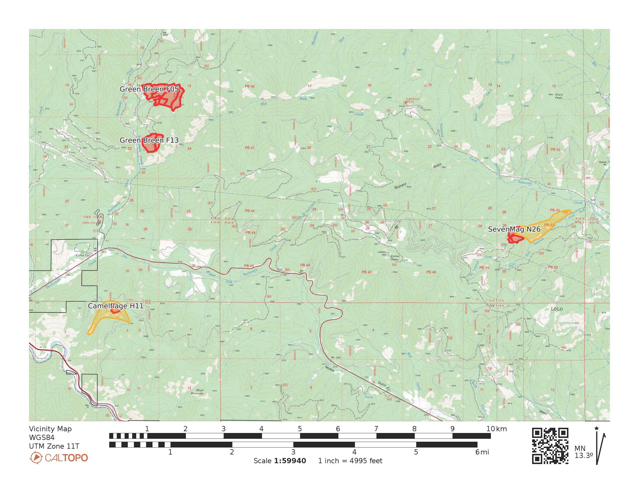
Superior Ranger District:
Pending conditions, prescribed fire operations will take place today and tomorrow to reduce hazardous fuels from previous vegetation management operations. Firefighters will conduct up 185 acres of prescribed burning in three locations near Cabin City; 2 miles northeast of Cabin City up 12 Mile Creek; half a mile south of Cabin City near Boyd Mountain; 5 miles north of St. Regis up the South Fork Tamarack Creek. These prescribed burns will utilize aerial ignitions. Residents in St. Regis, Cabin City, Henderson, and De Borgia may see smoke during operations. Firefighters and engines will implement the prescribed burn, patrol, and monitor the burning over the next few days.
Map of Prescribed Fire Units