
Floods Follow Fires
Related Incident:
Publication Type: News
Floods Follow Fires
Wildfires raise your floo
d risk by leaving the ground charred, barren, and unable to absorb water. That means even light rain can potentially turn into a financially devastating flash flood or mudflow and can occur with very little warning. This increased runoff may continue for several years after an area has burned and until vegetation is reestablished.
See below for important fact sheets:
Floods Follow Fires - El aumento en el Riesgo de Inundacion Despues de un Incendio
Understanding Mudflows - Las Avalanchas de lodo
Post-Fire Debris Flows
Debris flows are a common occurrence after an area has burned. As water runs downhill through burned areas, it can create erosion and undercut previously stable areas which causes large amounts of burned material (ash, sand, silt, rocks, trees) to become loose. As water and the material begin to move, the risk of damage to downhill areas increases.
Be prepared - Create an Emergency Response Plan
Due to the topography and proximity to mountainous areas in Pima County, there is sometimes little to no warning of impending flash floods or debris flows. In the event of moderate to heavy rainfall it is best to take any emergency steps necessary to protect your life and property. Plan in advance to move away from the area and have a safety plan already in place. Plan ahead by creating an Emergency Response Plan.
Be Flood Safe
Many people do not associate Arizona with flooding, but a 2017 analysis determined that Pima County was the eighth deadliest county in the nation for flood related deaths in the preceding 20 years. That normally dry wash on your property or roadway could present a very real danger to you in times of floods. These floods can happen any time of the year - during a heavy summer monsoon storm, or during a long, slow winter storm. Flash floods can occur many miles away from the storm event that causes them. It is important to Be Flood Safe ahead of a rain storm.
Flood Insurance
The time to buy flood insurance is now. Homeowners, renters and business owners need to protect themselves financially from the devastating losses flooding can bring - including after a wildfire - before the next weather event occurs.
In general, new policies for flood insurance become effective following a 30-day waiting period. However, the Biggert-Waters Flood Insurance Reform Act of 2012 provided an additional exception to this requirement related to flooding caused by post-wildfire conditions, referred to as the Post-Wildfire Exception. Under the Post-Wildfire Exception, the standard 30-day waiting period does not apply to new policies if:
- The covered property experiences damage caused by flood that originated on Federal land;
- Post-wildfire conditions on Federal lands caused or worsened the flooding; and
- The policyholder purchased the policy either:
- Before the fire containment date; or
- During the 60-day calendar-day period following the fire containment date
Resources
Wildfires: You Need Flood Insurance
Guidance on the Application of Post-Wildfire Exception to 30-day Waiting Period for New Policies
Bighorn Fire June 21 2020 Evening Update
Related Incident:
Publication Type: News
Bighorn Fire – June 21, 2020 Evening Update
Incident Management Team to transfer command Monday evening
Acres: 51,628
Percent Containment: 16%
Start Date: June 5, 2020
Cause: Lightning
Origin Location: Santa Catalina Mountains
Personnel: 969
Injuries: 3 minor heat-related illnesses
Jurisdiction: Coronado National Forest, including portions of the Pusch Ridge Wilderness
Resources: 7 hotshot crews, 14 Type 2 hand crews, 2 Type 1 engines, 28 Type 3 engines, 5 Type 4 engines, 17 Type 5 engines, 25 Type 6 engines, 5 Type 1 helicopters, 1 Type 2 helicopter, 2 Type 3 helicopters, 19 water tenders, 6 bulldozers
Southwest Area Type 1 Incident Management Team 2 will transfer command of the Bighorn Fire to Northern Rockies Type 1 Incident Management Team 1 tomorrow, June 22, at 6PM. The teams will hold a joint virtual community meeting streamed via Facebook Live at facebook.com/bighorn at 8PM tomorrow, Monday night, June 22.
Crews are preparing to conduct additional burnout operations tonight between the communities of Oracle and Saddlebrooke to buffer against fire burning on Samaniego Ridge and in Cargodera Canyon. On Mt. Lemmon, firefighters initiated burnout operations starting at Radio Ridge moving toward Summerhaven along the wilderness boundary. This burnout will continue into the evening. Additionally, crews are setting up pumps and sprinklers around structures in the area of Willow Canyon as a contingency measure. Fire managers do not anticipate the fire in Ventana Canyon will have much, if any movement. Crews will patrol the area tonight to monitor the fire upslope.
Evacuation Notices
GO - Evacuate
Mt. Bigelow & Lower Soldier HOA
Community of Summerhaven
Willow Canyon
Peppersauce Canyon to Highjinks Road and Campo Bonito
SET – Be Alert
Community of Oracle
Portions of East Golder Ranch
Catalina Foothills between Alvernon Way and Sabino Canyon Road, North of Skyline Drive
READY – Prepare Now
Oro Valley area from Catalina State Park south to Magee Road
Tucson foothills area from First Avenue east to Alvernon Way
Sign up to receive Pima County emergency alerts at myalerts.pima.gov and Pinal County alerts at pinalcountyaz.gov/emergencymanagement.
Closures: The Coronado National Forest closure order includes Sabino and Bear Canyons. Catalina State Park is closed. View the closure orders and maps at inciweb.nwcg.gov/incident/closures/6741/.
Catalina Highway is closed to the public at milepost zero. Only residents and business owners may pass. Oracle Control Road is closed.
Fire Information Phone Line: (520) 276-8981 and (520) 329-7439, 8AM-8PM
Media Phone Line: (520) 329-7640, 8AM-8PM
InciWeb: inciweb.nwcg.gov/incident/6741/
Facebook: facebook.com/bighornfireinfo
Smoke Outlook: wildlandfiresmoke.net/outlooks/EasternArizona
###
Bighorn Fire June 222020 Fire Information Guide
Related Incident:
Publication Type: Announcement
Bighorn Fire - June 22, 2020 Information Map Both Pima and Pinal Counties have communities under a GO Alert Status. Find their information here.
Pima County Information Below:
NOTE: For evacuation information in PIMA County call the Pima County Sheriff's Office 520 351-4600.
https://www.facebook.com/pimasheriff/
https://www.facebook.com/PinalCountySO/
Pima County Floods Fllow Fires
Pinal County Information Below:
Pinal County Interactive Maps
Pinal County Citizen Contact Center – 520-509-3555
Pinal County Sheriff’s Office Facebook link - https://www.facebook.com/PinalCountySO
Pinal County OEM Twitter link - https://twitter.com/home
Pinal County Fairgrounds Address – 512 Eleven Mile Corner, Casa Grande, AZ 85194
Pinal County Animal Control number – 520-509-3555
Bighorn Fire Links and information are updated as soon as it is available
Floods Follow Fires An important new article to help you prepare for possible consequences of the Bighorn Fire on your homes and property
Bighorn Fire - JUne 22, 2020 Morning UPdate with attachments
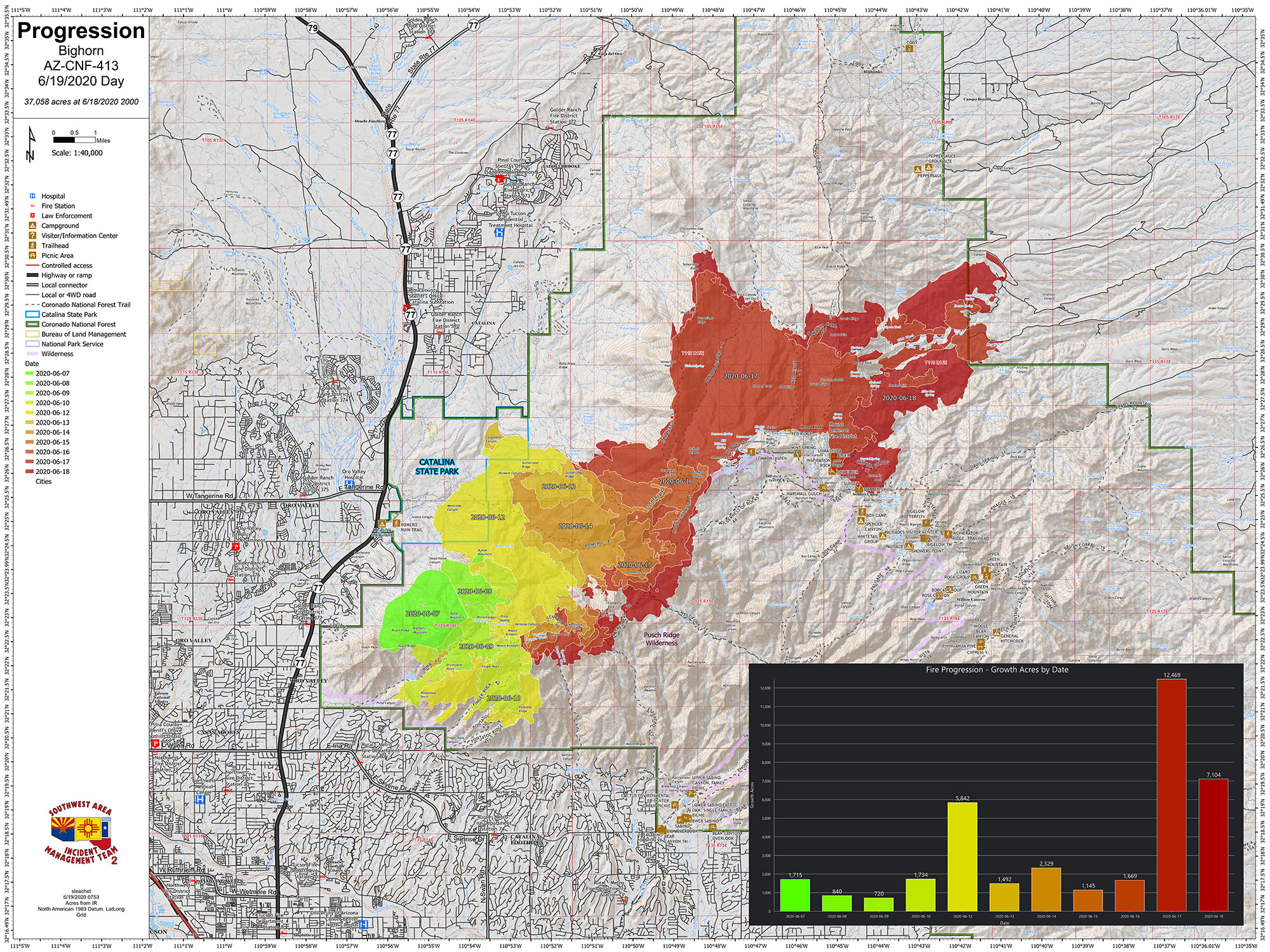
Bighorn Fire June 22, 2020 Progression Map JPGF Format
Bighorn Fire - June 22, 2020 Info map JPG Format withh attached pdf
wildlandfiresmoke.net/outlooks/EasternArizona
Bighorn Fire June 21 2020 Morning Update
Related Incident:
Publication Type: News
Bighorn Fire – June 21, 2020 Morning Update
Crews stay focused on keeping Bighorn Fire in check as Incident Management Team plans for transition
Catalina State Park is closed.
View the closure orders and maps at inciweb.nwcg.gov/incident/closures/6741/.
Catalina Highway is closed to the public at milepost zero. Only residents and business owners may pass. Oracle Control Road is closed.
###
Bighorn Fire June 20 2020 Evening Update
Related Incident:
Publication Type: News
Bighorn Fire – June 20, 2020 Evening Update
Slow but steady fire growth anticipated
Bighorn Fire June 20 2020 Morning Update
Related Incident:
Publication Type: News
Bighorn Fire – June 20, 2020 Morning Update
Challenging fire activity will engage crews to the north, south, and east
Sign up to receive Pima County emergency alerts at myalerts.pima.gov and Pinal County alerts at pinalcountyaz.gov/emergencymanagement.
View the closure maps at inciweb.nwcg.gov/incident/closures/6741/. Catalina Highway is closed to the public at milepost zero. Oracle Control Road is closed.
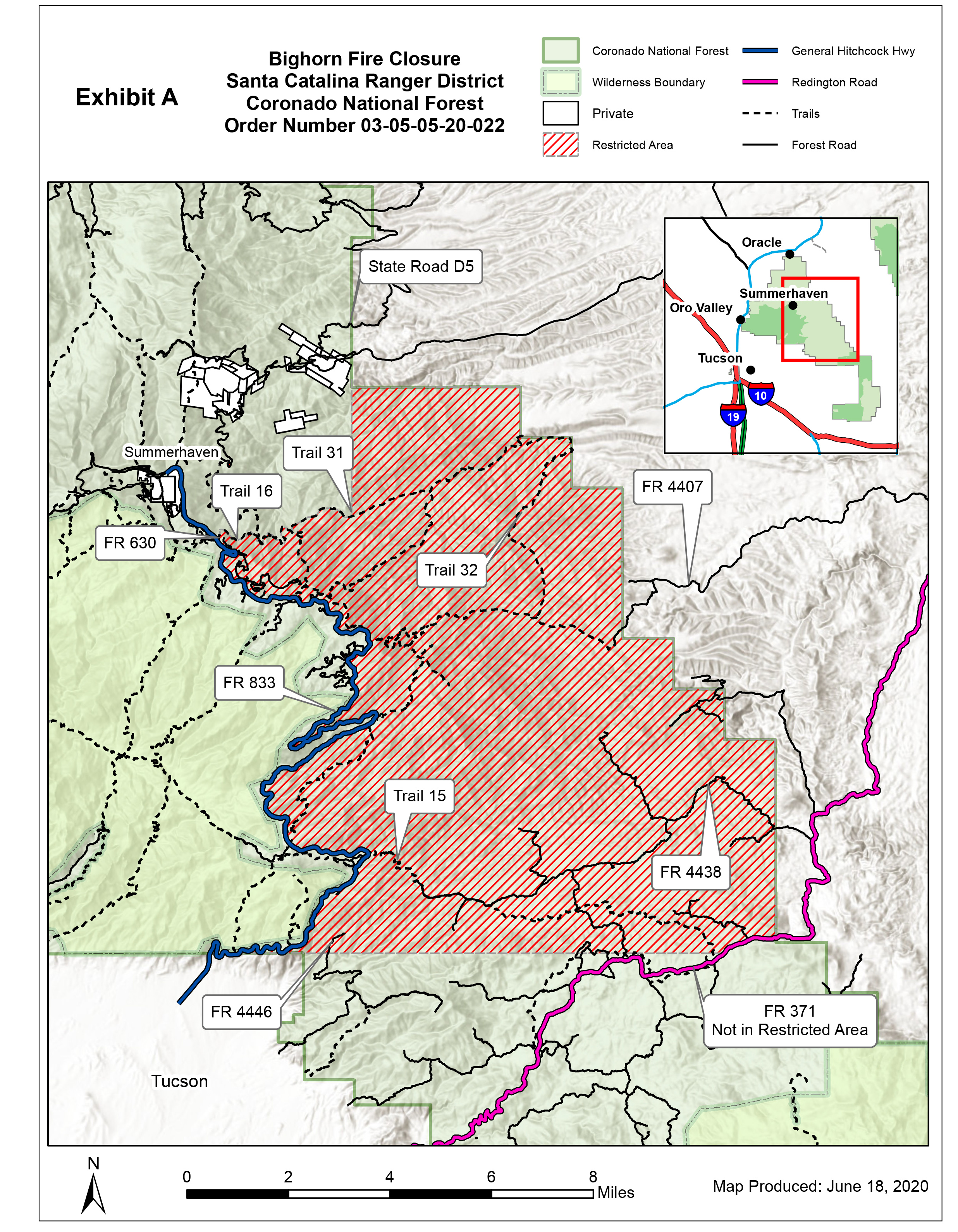
AREA CLOSURE Order Number 03050520022
Related Incident:
Publication Type: Closures

UNITED STATES DEPARTMENT OF AGRICULTURE
AREA CLOSURE
Order Number: # 03-05-05-20-022
PROHIBITIONS
36 C.F.R. § 261.53(e).
RESTRICTED AREA
PURPOSE
IMPLEMENTATION
 KERWIN DEWBERRY
 KERWIN S. DEWBERRY
Bighorn Fire June 19 2020 Morning Update
Related Incident:
Publication Type: News
Bighorn Fire – June 19, 2020 Morning Update
Increase in smoke visibility today
Acres: 37,058
Percent Containment: 40%
Start Date: June 5, 2020
Cause: Lightning
Origin Location: Santa Catalina Mountains
Personnel: 924
Injuries: 3 minor heat-related illnesses
Jurisdiction: Coronado National Forest, including portions of the Pusch Ridge Wilderness
Resources: 8 hotshot crews, 12 Type 2 hand crews, 2 Type 1 engines, 27 Type 3 engines, 4 Type 4 engines, 31 Type 6 engines, 3 Type 1 helicopters, 1 Type 2 helicopter, 2 Type 3 helicopters, 11 water tenders, 6 bulldozers
Due to lower wind speeds, smoke will be more settled and visible in the communities around the fire area. Today’s weather will exemplify a typical June Southern Arizona day, with temperatures around 100 degrees, low humidity and mild winds.
Fire managers expect growth to the northeast in Cañada del Oro and Alder Canyons today. Crews working south of Oracle and San Manuel will tie in containment lines today, in preparation for additional firing operations this evening. Firefighters on Mt. Lemmon are using all available tools, including controlled burning, to protect the communities along the Catalina Highway.
As the high winds that had been keeping the fire burning up on Samaniego Ridge and at the top of Ventana Canyon subside, the public can expect to see fire move downslope at a moderate pace. The fire still has a long way to move before crews can successfully engage it on flat ground.
Wildfires are a No Drone Zone. If you fly, we can’t. A temporary flight restriction is in place over the fire area.
Evacuation Notices
GO - Evacuate
Mt. Bigelow & Lower Soldier HOA
Community of Summerhaven Willow Canyon
Peppersauce Canyon to Highjinks Road and Campo Bonito
SET – Be Alert
Community of Oracle
Portions of East Golder Ranch
Catalina Foothills between Alvernon Way and Sabino Canyon Road, North of Skyline Drive
READY – Prepare Now
Oro Valley area from Catalina State Park south to Magee Road
Tucson foothills area from First Avenue east to Alvernon Way
Visit pima.gov/bighorn for the most up-to-date information on evacuation notices, an interactive map, and county resources. Sign up to receive Pima County emergency alerts at myalerts.pima.gov and Pinal County alerts at pinalcountyaz.gov/emergencymanagement.
Closures: The Coronado National Forest closure order includes Sabino and Bear Canyons. Catalina State Park is closed. View the closure orders and maps at inciweb.nwcg.gov/incident/closures/6741/. Catalina Highway is closed to the public at milepost zero. Only residents and business owners may pass. Oracle Control Road is closed.
Fire Information Phone Line: (520) 276-8981 and (520) 329-7439, 8AM-8PM
Media Phone Line: (520) 329-7640, 8AM-8PM
InciWeb: inciweb.nwcg.gov/incident/6741/
Facebook: facebook.com/bighornfireinfo
Smoke Outlook: wildlandfiresmoke.net/outlooks/EasternArizona
###
Bighorn Fire June 18 2020 Evening Update
Related Incident:
Publication Type: News
Bighorn Fire – June 18, 2020 Evening Update
Firefighters take advantage of lighter winds
Acres: 31,208
Percent Containment: 40%
Start Date: June 5, 2020
Cause: Lightning
Origin Location: Santa Catalina Mountains
Personnel: 924
Injuries: 3 minor heat-related illnesses
Jurisdiction: Coronado National Forest, including portions of the Pusch Ridge Wilderness
Resources: 8 hotshot crews, 12 Type 2 hand crews, 2 Type 1 engines, 27 Type 3 engines, 4 Type 4 engines, 31 Type 6 engines, 3 Type 1 helicopters, 1 Type 2 helicopter, 2 Type 3 helicopters, 11 water tenders, 6 bulldozers
Tonight, crews will get a slight reprieve from the wind events that have been stoking the Bighorn Fire since Tuesday. Unfortunately, the humidity will remain too low to significantly reduce fire behavior. On Mt. Lemmon, firefighters are working in the Bear Wallow area down through Willow Canyon HOA, clearing fire line from the 2002 Bullock and 2003 Aspen Fires. This work will protect values at risk from the spot fires in Stratton and Alder Canyons that grew together over the course of the day. Air tankers continued to drop fire retardant throughout the day to limit spread of the fire burning in the Wilderness of Rocks.
The fire spread further northeast today reaching Pig Spring, with slow fire progression expected overnight. Depending on weather conditions, crews may conduct backburn operations south of Oracle and San Manuel tonight to create a buffer between the fire and those communities.
Fire burning on Samaniego Ridge and in Ventana Canyon will continue to be visible and slowly back downslope. Fire managers are confident in the preparatory work crews have done in those areas to hold the fire.
Evacuation Notices
GO - Evacuate
SET – Be Alert
READY – Prepare Now
· Mt. Bigelow & Lower Soldier HOA
· Community of Summerhaven
· Willow Canyon
· Peppersauce Canyon to Highjinks Road and Campo Bonito
· Community of Oracle
· Portions of East Golder Ranch
· Catalina Foothills between Alvernon Way and Sabino Canyon Road, North of Skyline Drive
· Oro Valley area from Catalina State Park south to Magee Road
· Tucson foothills area from First Avenue east to Alvernon Way
Visit pima.gov/bighorn for the most up-to-date information on evacuation notices, an interactive map, and county resources. Sign up to receive Pima County emergency alerts at myalerts.pima.gov and Pinal County alerts at pinalcountyaz.gov/emergencymanagement.
Closures: The Coronado National Forest closure order includes Sabino and Bear Canyons. Catalina State Park is closed. View the closure orders and maps at inciweb.nwcg.gov/incident/closures/6741/. Catalina Highway is closed to the public at milepost zero. Only residents and business owners may pass. Oracle Control Road is closed.
Fire Information Phone Line: (520) 276-8981 and (520) 329-7439, 8AM-8PM
Media Phone Line: (520) 329-7640, 8AM-8PM
InciWeb: inciweb.nwcg.gov/incident/6741/
Facebook: facebook.com/bighornfireinfo
Smoke Outlook: wildlandfiresmoke.net/outlooks/EasternArizona
###
GO Alert for Peppersauce Canyon to Highjinks RdCampo Bonito area of Oracle
Related Incident:
Publication Type: News
This is a joint message from the Pinal County Sheriff's Office and Pinal County Office of Emergency Management regarding the
A "Go! - Evacuate" alert has been issued for residents in the area of Peppersauce Canyon to Highjinks Rd./ Campo Bonito area of Oracle.
Residents should evacuate immediately to a shelter or with family or friends outside of the affected area.
The Red Cross has set up an evacuation center at the C.D.O. High School in Oro Valley. Large animal sheltering will be done at the Pinal County Fairgrounds at 512 Eleven Mile Corner, Casa Grande, AZ 85194.
An interactive map outlining fire alert zones is available here: http://bit.ly/PCBigHornFire
Questions for residents in the area can be directed to the Pinal County Citizen Contact Center at 520-509-3555.
If you choose to ignore this advisement, you must understand emergency services may not be able to assist you further. Follow instructions from emergency personnel, stay on designated evacuation routes and avoid closed areas.