
Ojo De Los Casos Crews Provide Mutual Aid on Grass Fire
Related Incident:
Publication Type: News
How a dirty burn affects wildfire containment percentage
Related Incident:
Publication Type: News
July 11, 2020 Mountainair, NM – For Immediate Release
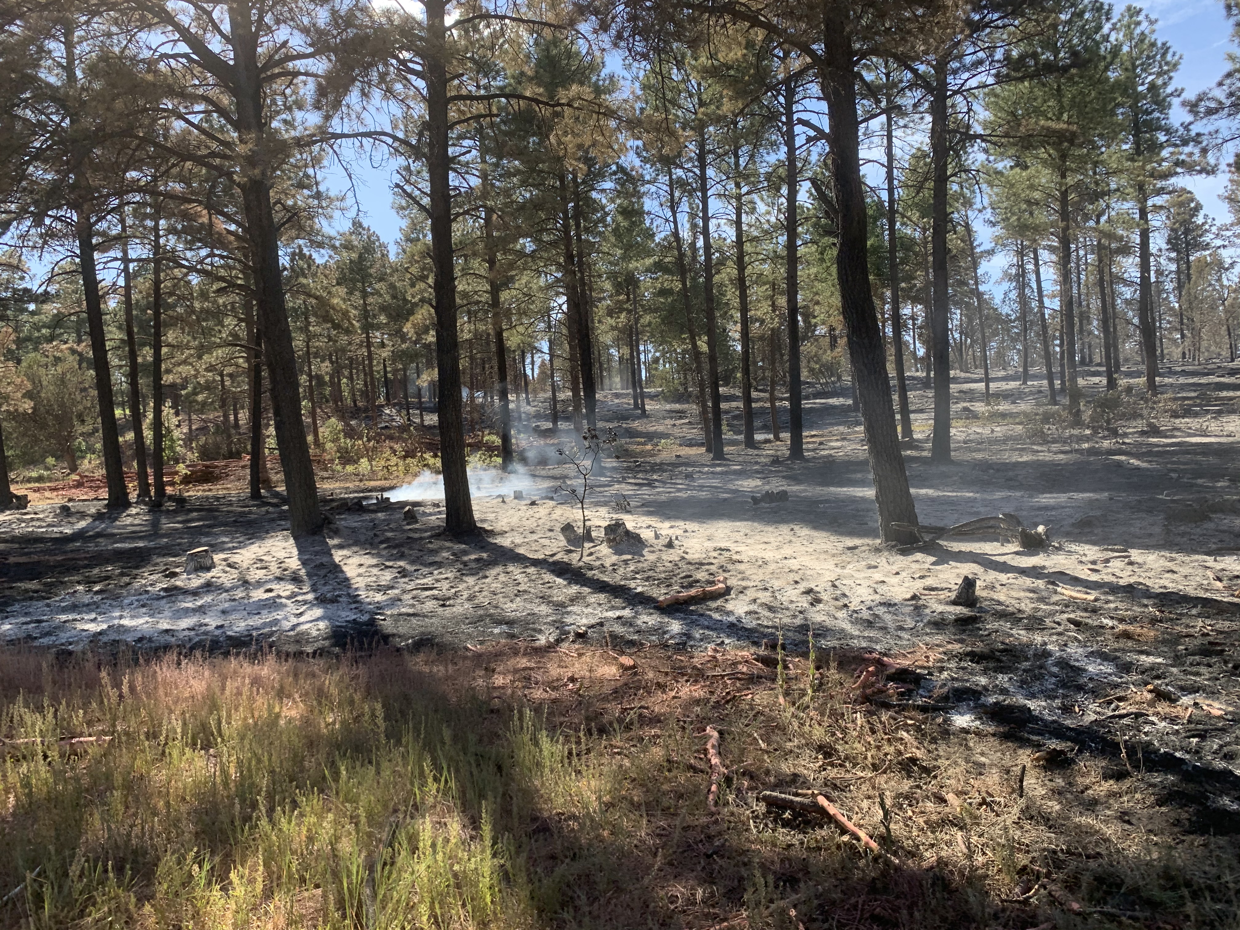
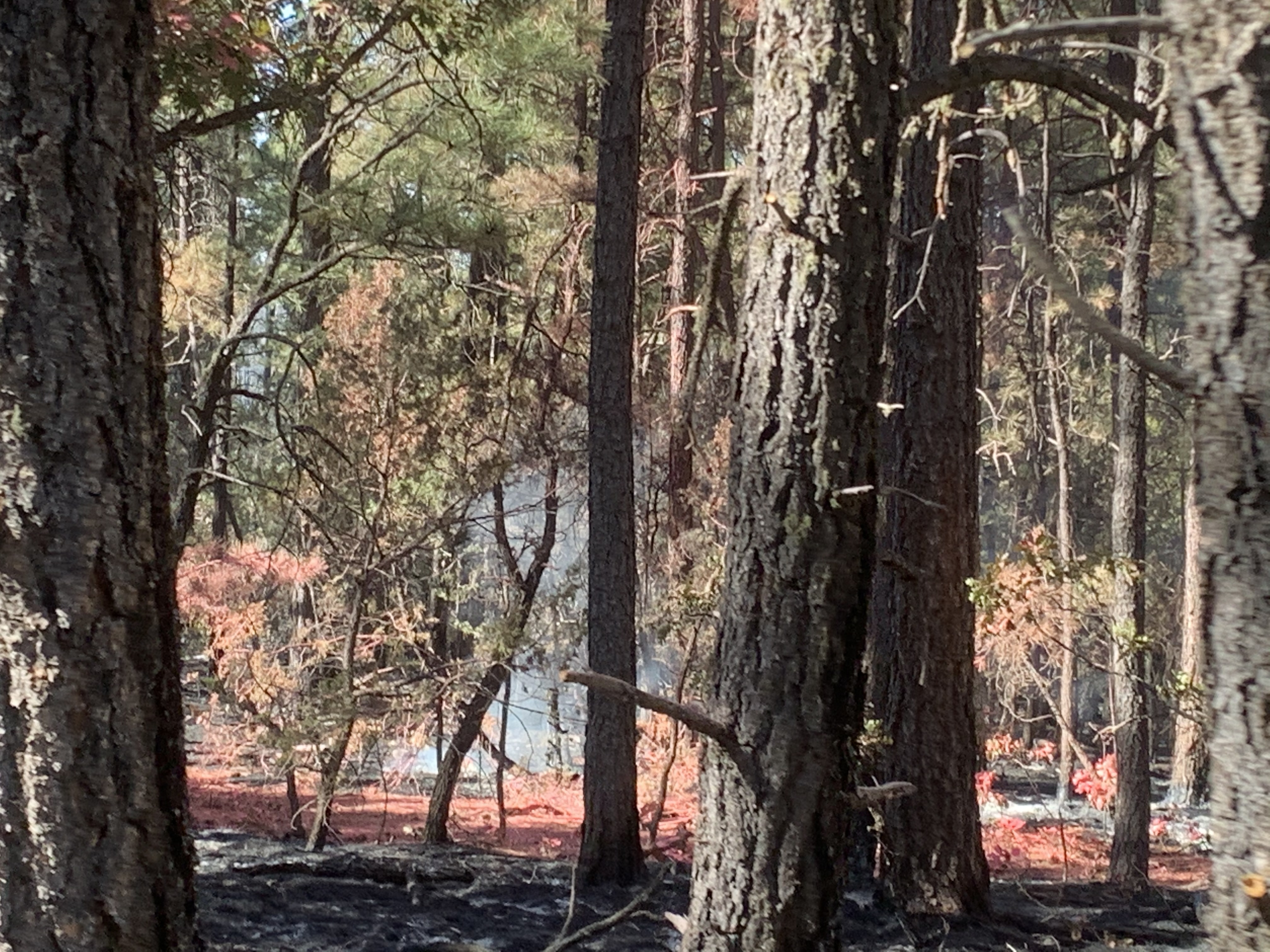
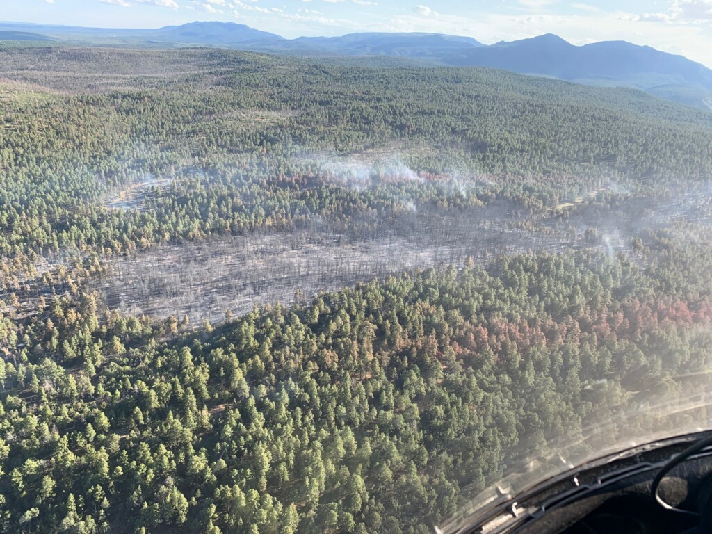
Wildfire perimeters aren’t always easy to define. When drawn on a public map, they are often depicted as one simple line to describe the outermost bounds of the area that is burning. However, fire may not burn evenly throughout the interior of that fire, so things might look quite different on the ground. The reasons for the manner of fire spread are numerous (e.g., weather, fuel loads, suppression actions). The Ojo de los Casos Fire falls into this category.
This fire is made up of many patches of burned and unburned vegetation. In cases such as this, lingering heat can hide within unburned fuels close to the ground. This heat may not be recognized until weather and fuel conditions are just right for ignition. Once ignited, these areas could burn hot and fast. Firefighters call this a “dirty” or “scabby” burn.
Complete “containment” is the ultimate goal for the fire management team in command of fire suppression activities. To reach containment, fire managers must attain a high level of confidence that the fire will not spread beyond a defined boundary and that unburned fuels within the perimeter and in the surrounding landscape are not at risk of igniting (spot fires). Until firefighters have a high level of confidence that no significant heat resides adjacent to the physical containment line, containment percentage estimates remain conservative.
Ojo de Los Casos Fire Information: 505-369-6521, 2020.ojodeloscasos@firenet.gov
Inciweb: https://inciweb.nwcg.gov/incident/6837/
New Mexico Fire Information: www.nmfireinfo.com
Facebook: Cibola National Forest & National Grasslands (@cibolanf) https://www.facebook.com/cibolanf/
Twitter: Cibola NF&Grasslands; (@Cibola_NF) https://twitter.com/cibola_nf?lang=en
YMCA A Fire and a Mountain
Related Incident:
Publication Type: News
We’ve had several questions about why the YMCA Fire is so named. That’s an easy question to answer. Fires are often named for the topographical feature on which they started, and the YMCA Fire was started by a lightning strike on YMCA Mountain four miles west of Canon City on July 8.
A much harder question is why the mountain is named YMCA. According to the Royal Gorge Regional Museum and History Center, the mountain was likely named many years ago for the local Young Men’s Christian Association (YMCA), who found the site a popular destination for hiking and mountain climbing. The mountain was renamed in 1943 to Land’s Peak in honor of prominent local citizen Emory S. Land. But that name didn’t stick, and the name eventually reverted back to YMCA. For a full account of the story, you can read about it in the Royal Gorge Regional Museum & History Center's blog.
July 13 YMCA Fire Update 10 AM
Related Incident:
Publication Type: News
YMCA Fire Update
July 13, 2020 10:00 a.m.
Bureau of Land Management
Front Range Fire and Aviation Management Unit
Nick Boucher, Incident Commander
Don Iles, Incident Commander Trainee
Crews continue monitoring YMCA Fire
Current Situation: The YMCA Fire remains at 303 acres and 60% containment. On Sunday, the two hand crews and one engine that remain assigned to the fire continued patrolling established lines as well as continuing line construction in areas that are accessible. An afternoon thunderstorm brought gusty winds to the area with very little rain, but established control lines held through the wind event.
At 5 p.m. on Sunday, Incident Command transitioned to a Type 4 organization led by Incident Commander Nick Boucher and Incident Commander Trainee Don Iles, both of the Helena-Lewis and Clark National Forest. Incident Commanders Boucher and Iles will be leading the resources assigned to the YMCA Fire in the coming days.
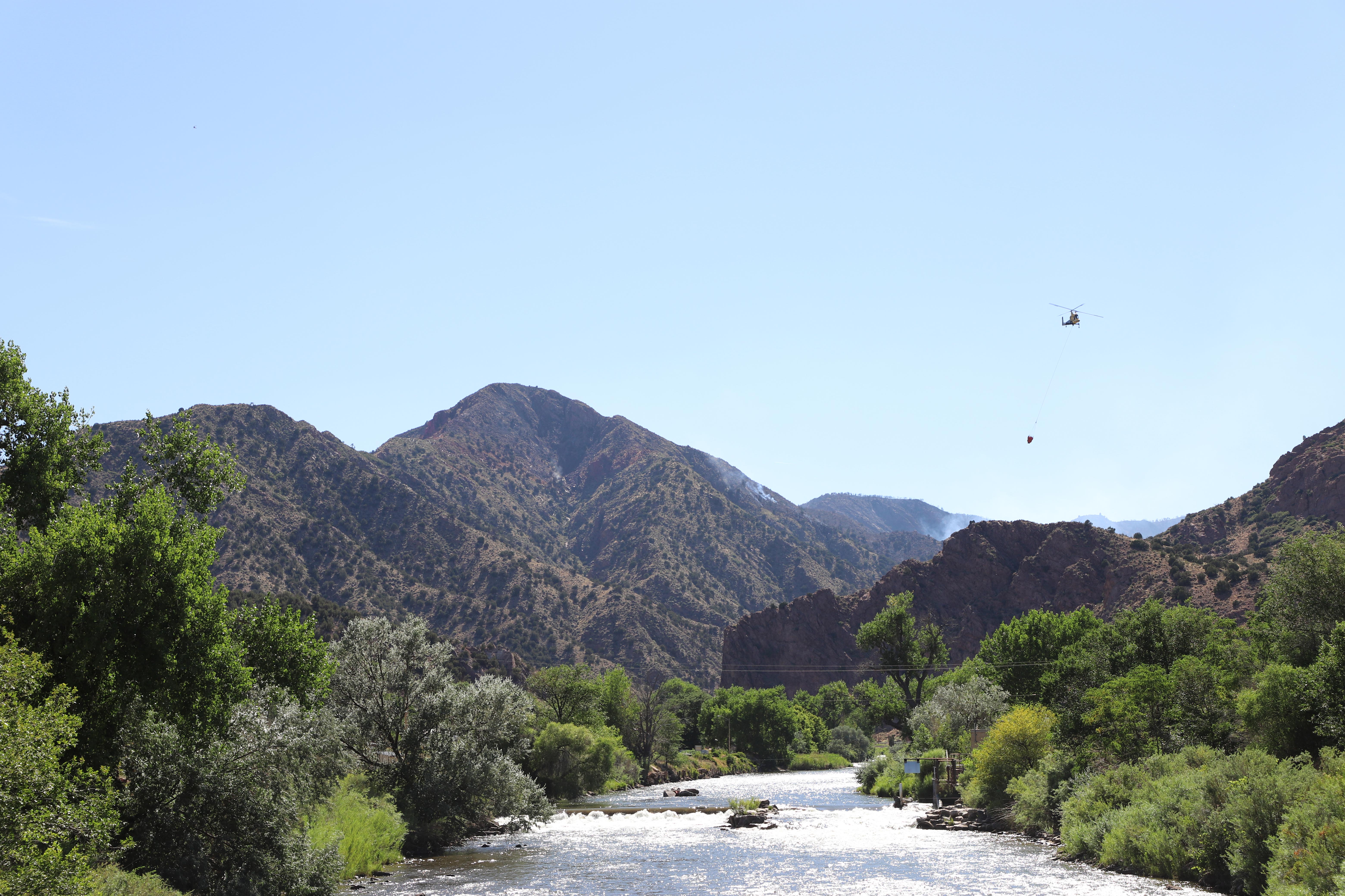
On Monday, two hand crews and one engine will continue mopping up, improving, and patrolling established lines as well as continuing line construction in areas that are accessible. The northern edge of the fire lies in steep, rocky terrain that is inaccessible to ground resources. Crews will continue monitoring this part of the fire’s perimeter, but without safe access, cannot construct a control line to consider the fire “contained” in this area. The Type 1 helicopter will remain assigned to the fire Monday to address any hot spots that may emerge on the north side of the fire. Isolated spots along this north edge or still-burning interior fuels may produce smoke visible from Cañon City in the coming days.
This morning’s YMCA Fire update will be the last issued in this format unless notable events occur. The Facebook page, Inciweb site, and Twitter feed will continue to be updated as information becomes available. The fire information office phone line will remain available to the public and media, with reduced hours of 8 a.m. to 6 p.m. today. The information office will be available for calls beyond Monday, but the office will not be staffed. Messages left at that number will be returned.
Weather: Monday is expected to bring sunny skies until scattered thunderstorms move into the area after 1 p.m. Temperatures will again be in the low-to-mid 90s with minimum humidity between 10 and 15%. Winds are forecast to be 10-15 mph with gusts up to 24 mph. Afternoon thunderstorms could bring gusty and erratic winds to the fire area.
Fire Restrictions: Fire restrictions are in place on Bureau of Land Management-Royal Gorge Field Office lands, US Forest Service-Pike San Isabel National Forest, and Fremont County.
Temporary Flight Restrictions: A Temporary Flight Restriction is in place over the YMCA Fire. Wildfires are a No Drone Zone. If you fly, we can’t. Every time a drone is spotted near the fire all aircraft are grounded until we can be sure the drone is clear of the area. For more information, visit http://knowbeforeyoufly.org.
YMCA Fire Contact Information:
Fire Information Office: (719) 315-0690
Email: 2020.ymca@firenet.gov
Inciweb: https://inciweb.nwcg.gov/incident/6836/
Facebook: facebook.com/YMCAFireCO
Twitter: twitter.com/YMCAFireCO
YMCA Fire Statistics:
Reported: July 8, 3:37 p.m.
Location: 4 miles SW of Cañon City, CO
Size: 303 acres
Personnel: 74
Percent Contained: 60%
Cause: Lightning
July 12 YMCA Fire Update 7 PM
Related Incident:
Publication Type: News
July 12, 2020 7:00 p.m.
YMCA Fire transitions to Type 4 incident
July 12 YMCA Fire Update 1030 AM
Related Incident:
Publication Type: News
YMCA Fire Update
July 12, 2020 10:30 a.m.
Bureau of Land Management
Front Range Fire and Aviation Management Unit Scott Nilson, Incident Commander
YMCA Fire now 60% contained, operations downsizing
Current Situation: Yesterday, containment on the YMCA Fire increased to 60%. Acreage increased to 303 acres due to improved mapping from an overflight early Sunday by the Colorado Department of Fire Prevention and Control Multi-Mission Aircraft. There was no detectable growth to the fire’s perimeter. Despite hot and dry conditions over the fire on Saturday, fire behavior was minimal. Afternoon winds tested containment lines and the lines held.
On Sunday, increased overnight humidity is expected to temper fire activity through the morning and possibly throughout the day. Firefighters will continue mopping up, improving, and patrolling established lines as well as continuing line construction in areas that are accessible. One Type 1 helicopter is available to address any hot spots within the fire perimeter or along the fire’s inaccessible northern perimeter.
The YMCA Fire will be downsizing operations today and making crews available for other assignments or to return to their home units to prepare for future fires in the region. As the operation downsizes, the fire will transition to a Type 4 incident this afternoon at 5 p.m., led by Incident Commander Nick Boucher and Incident Commander Trainee Don Iles, both of the Helena-Lewis and Clark National Forest. Incident Commanders Boucher and Iles will be leading two hand crews, one engine, and the Type 1 helicopter, which will remain assigned to the YMCA Fire in the coming days.
Although containment increased to 60% of the fire’s perimeter yesterday, smoke may continue to be visible from Canon City and neighboring areas. Interior fuels and portions of the inaccessible north edge of the fire are expected to continue burning and may produce smoke as temperatures rise into the afternoon.
Weather: On Sunday, temperatures are expected to be in the low-to-mid 90s with minimum humidity as low as 13%. Winds are forecast to be light through the morning, with the chance of afternoon thunderstorms. Thunderstorms could bring gusty and erratic winds to the fire area.
Fire Restrictions: Fire restrictions are in place on Bureau of Land Management-Royal Gorge Field Office lands, US Forest Service-Pike San Isabel National Forest, and Fremont County.
Temporary Flight Restrictions: A Temporary Flight Restriction is in place over the YMCA Fire. Wildfires are a No Drone Zone. If you fly, we can’t. Every time a drone is spotted near the fire all aircraft are grounded until we can be sure the drone is clear of the area. For more information, visit http://knowbeforeyoufly.org.
YMCA Fire Contact Information:
Fire Information Office: (719) 315-0690
Email: 2020.ymca@firenet.gov
Inciweb: https://inciweb.nwcg.gov/incident/6836/
Facebook: facebook.com/YMCAFireCO
Twitter: twitter.com/YMCAFireCO
YMCA Fire Statistics:
Reported: July 8, 3:37 p.m.
Location: 4 miles SW of Cañon City, CO
Size: 303 acres
Personnel: 139
Percent Contained: 60%
Cause: Lightning