
Pine Gulch Fire Virtual Public Meeting 6 pm Monday August 17
Related Incident:
Publication Type: Announcement
The Rocky Mountain Incident Management Team will hold a virtual public meeting livestreamed at 6 p.m. MT, TONIGHT, Monday, August 17.
Please go to Facebook, https://www.facebook.com/PineGulchFireCO/live/
To participate. Viewers do not need a Facebook account to view the meeting. The live stream will appear at the top of the Pine Gulch Fire Facebook page a few minutes before 6:00 p.m.
ZOOM can also be used to view the meeting, enter this code and password: Webinar ID: 979 6417 7398 Passcode: 767681
El equipo de gestión de incidentes de Rocky Mountain tendrá una reunión pública virtual transmitida en vivo a las 6 p.m. MT, ESTA NOCHE, lunes 17 de agosto.
Vaya a Facebook, https://www.facebook.com/PineGulchFireCO/live/ para participar. Los espectadores no necesitarán una cuenta de Facebook para ver la reunión. La transmisión en vivo aparecerá en la parte superior de la página de Facebook de Pine Gulch Fire un par de minutos antes de las 6:00 p.m.
ZOOM también se puede usar para ver la reunión, ingrese este código y contraseña: ID de la reunión: 979 7398 6417 Contraseña: 767681
Pine Gulch Fire Update August 17
Related Incident:
Publication Type: News
Pine Gulch Fire Update
August 17, 2020 - 9 a.m.
Rocky Mountain Incident Management Team - Dan Dallas, Incident Commander
Information Center: (970) 628-0130, 8 a.m. – 8 p.m.
Media Inquiries: (970) 812-3706, 8 a.m. – 8 p.m.
Special Notes: There will be a virtual public meeting livestreamed at 6 p.m. TONIGHT, Monday, August 17. Please go to Facebook, @PineGulchFireCO to participate, or you can find the link for a ZOOM meeting on our Facebook page and InciWeb. To utilize ZOOM, enter this code and password: Webinar ID: 979 7398 6417 Passcode: 767681
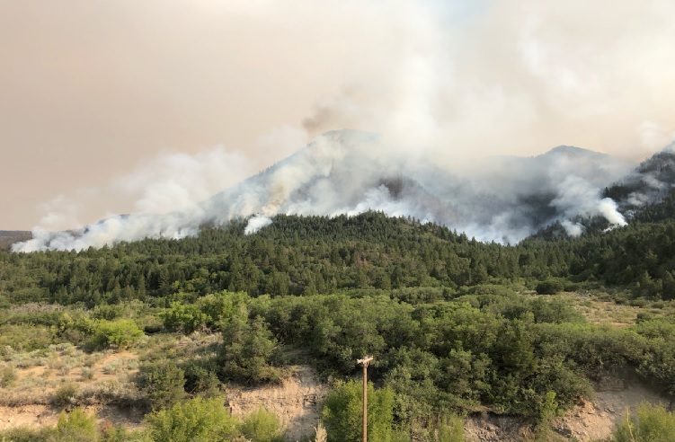
Current Situation: The fire and winds have aligned with drainages in several areas on the west. Fuels in these drainages are critically dry, creating the potential for significant fire behavior, spread and spotting. It is a crucial day for fire staff to implement plans; today presents an opportunity to successfully influence the duration of the Pine Gulch Fire. Crews will be working swiftly to seize control and suppression opportunities. Residents should fully expect to see smoke columns established in several areas of the fire today – multiple columns may be visible at once.
Fire staff will prioritize work in Divisions K, E, and D today. Fire in Division E on the west is approaching the indirect control line extending south along the ridge from the 204 Rd. to the Division E/D break. Firefighters will continue work on this line and, if conditions allow, may perform firing operations to help prevent fire spread toward the 205 Rd. Firefighters and heavy equipment have been successfully preparing the 205 Rd. as a secondary control line and will continue this work today. On the NW, in Division F, firefighters are scouting and creating secondary control line between the fire and Douglas Pass. Crews are also improving road systems to the SW of the fire in the event the fire grows in that direction. Division D on the southwest was active again yesterday, burning S and SW along Garfield Mesa and Ross Ridge. Firefighters are working on improving a two-track that runs from the southern tip of the fire area into the Hunter Fire burn scar, and they are scouting for ways to connect this line around the SW corner of the fire, back up to the Division D/E break. Excellent progress has been made in Divisions A and Z, and they are mostly in patrol and monitor status. Crews will continue to secure the fire’s edge in these two divisions.
Weather & Fuel Conditions: Temperatures highs of 95 and humidity 8-10%. Today will be smokey, as the inversion is not likely to lift until around 5 p.m. – if at all. Winds are from the N to NE, 4-9 mph throughout the day, with gusts up to 14 mph. Similar wind conditions as yesterday will exist in Divs. D and E, with winds coming from the S to SW and meeting up with northernly winds later in the afternoon.
Evacuations: Garfield County: Roan Creek (204) road, Clear Creek (211) road, Carr Creek (207) road, Brush Creek (209) road, CR 202. For more information: https://garfieldcounty.net/. Closures: Roan Creek Road (204) at North Dry Fork (200) road has a staffed closure. Travel is not recommended along the 21 Road north of Fruita or on the 16 Road/CR 205 north of the V 8/10 Rd. Barricades are in place on these roads.
Air Quality: Air Quality Health Advisories may be issued in areas near the Pine Gulch and Grizzly Creek fires. A smoke outlook for the Pine Gulch Fire is available where this update is posted and at https://fires.airfire.org/outlooks/WesternColorado. For more information on smoke levels, please visit https://airnow.gov.
Emergency Alerts: For Garfield County, please visit garco911.com. Mesa County alerts, please visit bit.ly/Emergency_Alerts.
Temporary Flight Restrictions: A Temporary Flight Restriction is in place over the Pine Gulch Fire. Wildfires are a No Drone Zone. If you fly, we can’t. For more information, visit http://knowbeforeyoufly.org.
Pine Gulch Fire Statistics:
Size: 85,407 acres
Containment: 7%
Total Personnel: 811
Location: Approximately 18 miles north of
Grand Junction, CO
Reported: July 31, approximately 5:15 p.m.
Cause: Lightning
For More Information:
Information Office: (970) 628-0130, 8 a.m. to 8 p.m.
Media Inquiries: (970) 812-3706, 8 a.m. – 8 p.m.
Email: 2020.PineGulch@firenet.gov
Inciweb: https://inciweb.nwcg.gov/incident/6906/
Facebook: https://facebook.com/PineGulchFireCO
Interactive Fire Map: https://arcg.is/W0izr
Smoke Outlook: https://fires.airfire.org/outlooks/WesternColorado
Resources Include: 5 Type 1 hand crews, 8 Type 2 hand crews, 9 helicopters, 55 engines, 8 bulldozers, 14 water tenders, and overhead/support personnel
Pine Gulch Fire Public Meeting Monday August 17 6 pm
Related Incident:
Publication Type: Announcement
There will be a virtual public meeting livestreamed at 6 p.m. on Monday, August 17. More information will be posted on Facebook and Inciweb.
Pine Gulch Fire Update Sunday August 16
Related Incident:
Publication Type: News
Pine Gulch Fire Update
August 16, 2020 - 9 a.m.
Rocky Mountain Incident Management Team - Dan Dallas, Incident Commander
Information Center: (970) 628-0130, 8 a.m. – 8 p.m.
Media Inquiries: (970) 812-3706, 8 a.m. – 8 p.m.
Special Notes: Because of an increase in fire behavior and the need for fire crews to work safely, two additional roads near the southwest side of the fire have been barricaded: the 21 Road northbound starting approximately three miles north of the BLM boundary, and the 16 Road northbound starting at the intersection of Coal Canyon Rd. (V 8/10 Rd.).
There will be a virtual public meeting livestreamed at 6 p.m. on Monday, August 17. More information will be posted on Facebook and Inciweb.
Current Situation: The Pine Gulch Fire is now 81,107 acres. Yesterday, winds shifted and aligned with drainages, contributing to active fire behavior on the southwest side in Division D. Fire burned during the day and into the night, moving onto Garfield Mesa and crossing the V 8/10 Rd. Today, additional resources will arrive to this area, and crews will utilize road systems and handline to reduce fire spread to the south. While higher elevation winds will come from the NE and NW today, lower level winds may also come from the S/SW in Division D. As these winds come together, they have the potential to create eddying effects and contribute to significant fire behavior in Division D.
Today in Division E on the northwest side, crews will utilize control line and burning operations when possible to help keep fire south of the 204 Rd. and limit spread to the west and north. In Division K on the north, there is still heat at the fire’s edge. Firefighters will be securing this edge and will keep mopping up and securing structures along the 204 Rd. where the fire has already passed through. Firefighters are successfully utilizing Unmanned Aircraft Systems (UAS) in Division K to conduct strategic aerial ignitions in the evening and night; conditions are most appropriate during this time. Use of this equipment also helps minimize firefighter exposure and risk. On the east side in Division Z, there has been some containment (black line) added, and containment here is expected to increase in the coming days. The fire on the east and southeast (Divisions Z and A) has been hung up in rocks and natural features with no recent growth. Structures have been successfully secured and protected in this area. Crews will keep securing the fire’s edge and mop up completed containment lines in Divisions Z and A.
Two new Divisions, F and L, have been added to the northwest and north, respectively. Crews and heavy equipment operators in this area are scouting to identify potential dozer and hand lines as secondary control features in the case of any fire spread to the north or northeast. They are preparing the 209 and 207 Roads and assessing structures in this area.
Weather & Fuel Conditions: Today will be another hot and dry day, with temperatures up to 93 and humidity between 6-9%. Winds are forecast from the NE at 5-8mph with gusts to 12mph, shifting to come from the N then NW in the afternoon at 8-12 mph with gusts to 18. The atmosphere remains unstable, and the combination of low humidity, susceptible fuels and winds could contribute to active fire behavior and spread.
Closures and Evacuations: Garfield County Sheriff’s Office issued an evacuation order for residents on Roan Creek (204) road, Clear Creek (211) road, Carr Creek (207) road and Brush Creek (209) road on Aug 9, 2020. Garfield County issued an evacuation order for residences on CR 202 on Saturday. For more information on evacuation orders, please visit https://garfieldcounty.net/. There is a road closure in effect on Roan Creek Road (204) at North Dry Fork (200) road; that closure is being staffed by a Sheriff’s deputy. The 21 Road northbound starting approximately three miles north of the BLM boundary, and the 16 Road northbound starting at the intersection of Coal Canyon Rd. (V 8/10 Rd.) are now barricaded.
Air Quality: Colorado Department of Public Health and Environment (CDPHE) has issued an Air Quality Health Advisory for points east of the Pine Gulch and Grizzly Creek fires. A smoke outlook for the Pine Gulch Fire is available where this update is posted and at https://fires.airfire.org/outlooks/WesternColorado. Continued widespread smoke from the Pine Gulch fire will impact many parts of Colorado Sunday morning into Sunday night. Areas affected downwind from the fires include Craig and Meeker to the north, along the I-70 corridor in central Colorado, and as far east as the Front Range region and eastern plains. This will bring periods of smoke rated as ‘moderate’ to levels ‘unhealthy for sensitive groups’ levels to areas northeast of the fire including Garfield County, Moffat County, Mesa County, and Rio Blanco County. Brief periods of heavy smoke will also be possible. For more information on smoke levels, please visit https://airnow.gov.
Emergency Alerts: Both Mesa and Garfield counties have emergency alert systems to alert citizens - by cell or land line phone - about emergencies, evacuations, and other important community news. To sign up for alerts in Garfield County, please visit garco911.com. For Mesa County alerts, please visit bit.ly/Emergency_Alerts.
Temporary Flight Restrictions: A Temporary Flight Restriction is in place over the Pine Gulch Fire. Wildfires are a No Drone Zone. If you fly, we can’t. Whenever a drone is spotted near the fire all aircraft are grounded until we can be sure the drone is clear of the area. For more information, visit http://knowbeforeyoufly.org.
Pine Gulch Fire Statistics:
Size: 81,107 acres
Containment: 7%
Total Personnel: 754
Location: Approximately 18 miles north of
Grand Junction, CO
Reported: July 31, approximately 5:15 p.m.
Cause: Lightning
For More Information:
Information Office: (970) 628-0130, 8 a.m. to 8 p.m.
Media Inquiries: (970) 812-3706, 8 a.m. – 8 p.m.
Email: 2020.PineGulch@firenet.gov
Inciweb: https://inciweb.nwcg.gov/incident/6906/
Facebook: https://facebook.com/PineGulchFireCO
Interactive Fire Map: https://arcg.is/W0izr
Smoke Outlook: https://fires.airfire.org/outlooks/WesternColorado
Resources Include: 4 Type 1 hand crews, 6 Type 2 hand crews, 9 helicopters, 57 engines, 8 bulldozers, 17 water tenders, and overhead/support personnel
Pine Gulch Fire Activity Increases Saturday Afternoon
Related Incident:
Publication Type: Announcement
Fire activity has picked up this afternoon in Division D on the southwestern portion of the Pine Gulch Fire due to a wind shift. The fire is burning very actively near Garfield Mesa and the V 8/10 Road. Firefighters are aware of the increase in fire behavior and movement and are focusing their efforts in that area. Firefighters are being supported with air tankers dropping retardant. More details will be provided as they become available.
Pine Gulch Fire Update Saturday August 15
Related Incident:
Publication Type: News
Pine Gulch Fire Update
August 15, 2020 - 10 a.m.
Rocky Mountain Incident Management Team - Dan Dallas, Incident Commander
Information Center: (970) 628-0130, 8 a.m. – 8 p.m.
Media Inquiries: (970) 812-3706, 8 a.m. – 8 p.m.
Current Situation: An overnight mapping flight measured the Pine Gulch Fire at 74,807 acres and it remains 7% contained.
Operations today will focus on the northern edge of the fire, with two new Divisions working on developing additional containment options along roads in the area of 204 Road, 207 Road, and 209 Road. Hand crews will continue to extend lines to the northwest along Kimball Mountain and near Mud Spring in Divisions K and E. Structure protection crews will also be patrolling and mopping up around structures where the fire has passed through. Burnout operations will take place only if fire behavior dictates, especially in areas closest to values at risk.
Bulldozers and hand crews will continue to work the northern edge and along 204 Road. Division K was the most active last night, with crews deploying an Unmanned Aircraft System (UAS) to conduct strategic aerial ignitions when the temperatures, winds and humidity were the most favorable. The black containment line held well in Division A despite the wind shift yesterday. Division D is exploring additional options to implement bulldozers to secure additional line near established roads. Division Z has been fairly quiet over the past several days, with the line along 204 holding well.
Weather & Fuel Conditions: Temperatures are expected to move into the 90’s with relative humidity between 8-10 percent. Winds will be out of the northwest, with speeds of 5-8mph and a few gusts up to 12mph. Smoke is expected to settle in the valley until early afternoon.
Closures and Evacuations: Garfield County Sheriff’s Office issued an evacuation order for residents on Roan Creek (204) road, Clear Creek (211) road, Carr Creek (207) road and Brush Creek (209) road on Sunday night. Garfield County issued an evacuation order for residences on CR 202 on Saturday. For more information on evacuation orders, please visit https://garfieldcounty.net/. There is a road closure in effect on Roan Creek Road (204) at North Dry Fork (200) road; that closure is being staffed by a Sheriff’s deputy.
Air Quality: Colorado Department of Public Health and Environment (CDPHE) has issued an Air Quality Health Advisory for points east of the Pine Gulch and Grizzly Creek fires. A smoke outlook for the Pine Gulch Fire is available where this update is posted and at https://fires.airfire.org/outlooks/WesternColorado. Continued widespread smoke from the Pine Gulch fire will impact many parts of Colorado Saturday morning into Saturday night. Areas affected downwind from the fires include Craig and Meeker to the north, along the I-70 corridor in central Colorado, and as far east as the Front Range region and eastern plains. This will bring periods of smoke rated as ‘moderate’ to levels ‘unhealthy for sensitive groups’ levels to areas northeast of the fire including Garfield County, Moffat County, Mesa County, and Rio Blanco County. Brief periods of heavy smoke will also be possible. For more information on smoke levels, please visit https://airnow.gov.
Emergency Alerts: Both Mesa and Garfield counties have emergency alert systems to alert citizens - by cell or land line phone - about emergencies, evacuations, and other important community news. To sign up for alerts in Garfield County, please visit garco911.com. For Mesa County alerts, please visit bit.ly/Emergency_Alerts.
Temporary Flight Restrictions: A Temporary Flight Restriction is in place over the Pine Gulch Fire. Wildfires are a No Drone Zone. If you fly, we can’t. Whenever a drone is spotted near the fire all aircraft are grounded until we can be sure the drone is clear of the area. For more information, visit http://knowbeforeyoufly.org.
Pine Gulch Fire Statistics:
Size: 74,807 acres
Containment: 7%
Total Personnel: 757
Location: Approximately 18 miles north of
Grand Junction, CO
Reported: July 31, approximately 5:15 p.m.
Cause: Lightning
For More Information:
Information Office: (970) 628-0130, 8 a.m. to 8 p.m.
Media Inquiries: (970) 812-3706, 8 a.m. – 8 p.m.
Email: 2020.PineGulch@firenet.gov
InciWeb: https://inciweb.nwcg.gov/incident/6906/
Facebook: https://facebook.com/PineGulchFireCO
Interactive Fire Map: https://arcg.is/W0izr
Smoke Outlook: https://fires.airfire.org/outlooks/WesternColorado
Resources Include: 3 Type 1 hand crews, 7 Type 2 hand crews, 9 helicopters, 57 engines, 8 bulldozers, 17 water tenders, and overhead/support personnel
Pine Gulch Fire Update Friday August 14
Related Incident:
Publication Type: News
Pine Gulch Fire Update
August 14, 2020 - 10 a.m.
Rocky Mountain Incident Management Team - Dan Dallas, Incident Commander
Information Center: (970) 628-0130, 8 a.m. – 8 p.m.
Media Inquiries: (970) 812-3706, 8 a.m. – 8 p.m.
Special Note: The Rocky Mountain Type 1 Incident Management Team (IMT), with Dan Dallas as Incident Commander, assumed command of the Pine Gulch Fire this morning at 6 a.m. The Team would like to acknowledge the great work that was done by Rocky Mountain Incident Management Team Black and wish them safe travels home.
Current Situation: An overnight mapping flight measured the Pine Gulch Fire at 73,381 acres and it remains 7% contained.
Operations today will focus on monitoring/patrolling and improving previously constructed fire lines, as well as scouting additional options in anticipation of afternoon winds out of the northwest. Burnout operations will take place only if fire behavior dictates, especially in areas closest to values at risk. Bulldozers and hand crews will continue to work the northern edge and along 204 Road on the east side.
The northwestern edge in Division E was the most active yesterday, and crews will continue to work on securing the fire line and tying in to the Division K line that has been holding well along 204 Rd. Division Z has been fairly quiet over the past several days, but afternoon winds may cause increased activity in that area. Structure protection crews will be out developing plans for areas southeast of the fire perimeter. Night shift made good progress in securing additional line overnight.
Weather & Fuel Conditions: Temperatures are expected to remain in the upper 80s with relative humidities still in the single digits. Winds should be lighter today but will be out of the west/northwest this afternoon. Down valley winds will be at 7-10 mph with gusts up to 15 mph. Afternoon winds should moderate fire activity in the W/NW areas of the fire but could create increased fire behavior to the E/SE in the afternoon.
Closures and Evacuations: Garfield County Sheriff’s Office issued an evacuation order for residents on Roan Creek (204) road, Clear Creek (211) road, Carr Creek (207) road and Brush Creek (209) road on Sunday night. Garfield County issued an evacuation order for residences on CR 202 on Saturday. For more information on evacuation orders, please visit https://garfieldcounty.net/. There is a road closure in effect on Roan Creek Road (204) at North Dry Fork (200) road; that closure is being staffed by a Sheriff’s deputy.
Air Quality: Colorado Department of Public Health and Environment (CDPHE) has issued an Air Quality Health Advisory for northern Mesa County, and central and eastern Garfield County. A smoke outlook for the Pine Gulch Fire is available where this update is posted and at https://fires.airfire.org/outlooks/WesternColorado. Continued widespread smoke from the Pine Gulch fire will impact many parts of Colorado on Wednesday. Areas affected downwind from the fires North to Meeker, along the I-70 corridor, and as far east as the Front Range region and the eastern plains. This will bring periods of mainly ‘moderate’ to ‘unhealthy for sensitive groups’ levels of smoke to areas northeast of the fire including Garfield County and Rio Blanco County, however brief periods of heavy smoke will also be possible. For more information on smoke levels, please visit https://airnow.gov.
Emergency Alerts: Both Mesa and Garfield counties have emergency alert systems to alert citizens - by cell or land line phone - about emergencies, evacuations, and other important community news. To sign up for alerts in Garfield County, please visit garco911.com. For Mesa County alerts, please visit bit.ly/Emergency_Alerts.
Temporary Flight Restrictions: A Temporary Flight Restriction is in place over the Pine Gulch Fire. Wildfires are a No Drone Zone. If you fly, we can’t. Whenever a drone is spotted near the fire all aircraft are grounded until we can be sure the drone is clear of the area. For more information, visit http://knowbeforeyoufly.org.
Pine Gulch Fire Statistics:
Size: 73,381 acres
Containment: 7%
Total Personnel: 794
Location: Approximately 18 miles north of
Grand Junction, CO
Reported: July 31, approximately 5:15 p.m.
Cause: Lightning
For More Information:
Information Office: (970) 628-0130, 8 a.m. to 8 p.m.
Media Inquiries: (970) 812-3706, 8 a.m. – 8 p.m.
Email: 2020.PineGulch@firenet.gov
InciWeb: https://inciweb.nwcg.gov/incident/6906/
Facebook: https://facebook.com/PineGulchFireCO
Interactive Fire Map: https://arcg.is/W0izr
Smoke Outlook: https://fires.airfire.org/outlooks/WesternColorado
Resources Include: 3 Type 1 hand crews, 7 Type 2 hand crews, 6 helicopters, 57 engines, 4 bulldozers, 17 water tenders, and overhead/support personnel
Pine Gulch Fire Progression map August 13
Related Incident:
Publication Type: News
This is a fire progression map of the Pine Gulch Incident. This map is a visual aid that shows the daily growth of the Pine Gulch Fire, with each day represented by a different color (see the key). This map a tool for fire managers to visualize incident development, which can assist them in fire behavior analysis and planning. It is also helpful for the public to see how the fire has grown each day.
You may notice the acreage on the progression map is different than what is being reported today. This perimeter data and acreage is from a flight yesterday afternoon, but the map is an effective visual aid to see the fire's daily growth leading up to that point in time.
August 13 Pine Gulch Fire Update
Related Incident:
Publication Type: News
Pine Gulch Fire Update
More Red Flag Conditions Expected Over Pine Gulch Fire
Emergency Alerts: Both Mesa and Garfield counties have emergency alert systems to alert citizens - by cell or land line phone - about emergencies, evacuations, and other important community news. To sign up for alerts in Garfield County, please visit garco911.com. For Mesa County alerts, please visit bit.ly/Emergency_Alerts.
| Pine Gulch Fire Statistics: Size: 68,323 acres Containment: 7% Total Personnel: 745 Reported: July 31, approximately 5:15 p.m. Cause: Lightning | For More Information: Information Office: (970) 628-0130, 8 a.m. to 8 p.m. Email: 2020.PineGulch@firenet.gov InciWeb: https://inciweb.nwcg.gov/incident/6906/ Facebook: https://facebook.com/PineGulchFireCO Interactive Fire Map: https://arcg.is/W0izr |


August 12 Pine Gulch Fire Update
Related Incident:
Publication Type: News
Pine Gulch Fire Update
Wednesday August 12, 2020 – 10:00 amRocky Mountain Incident Management Team Black
Troy Hagan, Incident Commander
Information Office: (970) 628-0130
Media Line: (970) 812-3706
Hours of Operation: 8 a.m. to 8 p.m.
Red Flag Conditions Push Pine Gulch Past 50,000 Acres
Current Situation: The Pine Gulch Fire grew to 51,455 acres on Tuesday and remains 7% contained. The fire was very active on Tuesday as it continued moving northeast. In addition to activity on the northeast head of the fire, there was also increased activity on the northwestern flank as the fire moved northeast across the 200 road and north over western Cow Ridge. There was some activity on the western end of the North Dry Fork (200) road in an area inaccessible to crews. That area is being monitored and is being addressed by bucket drops from helicopters. Overnight, night shift crews successfully conducted a firing operation south of the lines constructed along part of the 204 road and continued structure protection work on areas north of Kimball Mountain. On Wednesday, crews in Division A will be holding the southern perimeter along X ½ road. Divisions Z and G will continue their firing operations, as conditions allow, between North Dry Fork (200) road and the X ½ road on the southeast edge of the fire. The Roan Group will continue structure protection along areas north of the fire and will be monitoring the burn operation completed last night. As of this morning, the fire had not yet reached Roan Creek. Conditions over the Pine Gulch Fire are not expected to improve on Wednesday. Like yesterday, humidity will be low, temperatures high, and winds consistent through the day with gusts in the afternoon. The fire is expected to be very active again today.Weather & Fuel Conditions: A Red Flag Warning is in effect for the fire area again today. Temperatures are expected to reach 90 degrees over the fire and relative humidity is expected to drop as low as 6%. Winds today are expected to be similar to yesterday with down valley winds at 13-17 mph with gusts up to 27 mph. With the winds added to the already hot and dry conditions, there is a possibility for extreme, wind-driven fire behavior and high rates of spread, as we saw yesterday.
Closures and Evacuations: Garfield County Sheriff’s Office issued an evacuation order for residents on Roan Creek (204) road, Clear Creek (211) road, Carr Creek (207) road and Brush Creek (209) road on Sunday night. Garfield County issued an evacuation order for residences on CR 202 on Saturday. For more information on evacuation orders, please visit https://garfieldcounty.net/. There is a road closure in effect on Roan Creek Road (204) at North Dry Fork (200) road; that closure is being staffed by a Sheriff’s deputy.
Air Quality: Colorado Department of Public Health and Environment (CDPHE) has issued an Air Quality Health Advisory for western Mesa County and Garfield County. A smoke outlook for the Pine Gulch Fire is available where this update is posted and at https://fires.airfire.org/outlooks/WesternColorado. Continued widespread smoke from the Pine Gulch fire will impact many parts of Colorado on Wednesday. Areas affected downwind from the fires North to Meeker, along the I-70 corridor, and as far east as the Front Range region and the eastern plains. This will bring periods of mainly ‘moderate’ to ‘unhealthy for sensitive groups’ levels of smoke to areas northeast of the fire including Garfield County and Rio Blanco County, however brief periods of heavy smoke will also be possible. For more information on smoke levels, please visit https://airnow.gov.
Emergency Alerts: Both Mesa and Garfield counties have emergency alert systems to alert citizens - by cell or land line phone - about emergencies, evacuations, and other important community news. To sign up for alerts in Garfield County, please visit garco911.com. For Mesa County alerts, please visit bit.ly/Emergency_Alerts.
Temporary Flight Restrictions: A Temporary Flight Restriction is in place over the Pine Gulch Fire. Wildfires are a No Drone Zone. If you fly, we can’t. Whenever a drone is spotted near the fire all aircraft are grounded until we can be sure the drone is clear of the area. For more information, visit http://knowbeforeyoufly.org.
Pine Gulch Fire Statistics:Size: 51,455 acres
Containment: 7%
Total Personnel: 658
Location: Approximately 18 miles north of Grand Junction, CO
Reported: July 31, approximately 5:15 p.m.
Cause: Lightning
For More Information:Information Office: (970) 628-0130,
8 a.m. to 8 p.m.
Email: 2020.PineGulch@firenet.gov
InciWeb: https://inciweb.nwcg.gov/incident/6906/
Facebook: https://facebook.com/PineGulchFireCO
Interactive Fire Map: https://arcg.is/W0izr
Smoke Outlook: https://fires.airfire.org/outlooks/WesternColorado

