
Voluntary Evacuations for Hwy 34 from Drake to Dam Store
Related Incident:
Publication Type: Announcement
Cameron Peak Voluntary Evacuations for Hwy 34 advised
2020-10-14 14:48:18 MDT
The Larimer County Sheriff has ordered Voluntary evacuations for Highway 34 from Drake to just west of the Dam Store. Voluntary evacuations are advised for residents and business occupants if they are concerned for their safety, feel they need additional time to exit the area, or have health conditions that may be aggravated by this incident. You are encouraged to move livestock and pets out of the area and to prepare for mandatory evacuations. For updates, text the word LCEVAC to 888777 from your cell phone. We will communicate information to that key word as needed. To view a map of these areas, please visit nocoalert.org. Please do not call 9-1-1 unless you are in danger. Thank you.
Voluntary Evacuations Ordered for Lory State Park
Related Incident:
Publication Type: Announcement
The Larimer County Sheriff has ordered voluntary evacuations for Lory State Park.
Voluntary evacuations are advised for residents and business occupants if they are concerned for their safety, feel they need additional time to exit the area, or have health conditions that may be aggravated by this incident.
You are encouraged to move livestock and pets out of the area and to prepare for mandatory evacuations.
For updates, text the word LCEVAC to 888777 from your cell phone. To view a map of the evacuation areas, please visit nocoalert.org.
Please do not call 9-1-1 unless you are in danger.
Mandatory Evacuations for Masonville Bobcat Ridge Natural Area and More
Related Incident:
Publication Type: Announcement
The Larimer County Sheriff has ordered Mandatory Evacuations for the following areas:
Bobcat Ridge Natural Area, Masonville, Horsetooth Mountain Park/Overhill Dr/Milner Mountain, County Road 52E (Rist Canyon Road) from County Road 27 east to County Road 27E (all of Rist Canyon including Stratton Park).
For updates, text the word LCEVAC to 888777 from your cell phone. To view a map of the evacuation areas, please visit nocoalert.org. Please do not call 9-1-1 unless you are in danger.
Cameron Peak Virtual Community Meeting Wed October 14 2020 at 730pm
Related Incident:
Publication Type: Announcement
Please join us tonight, Wednesday October 14, 2020, for a Virtual Community Meeting at 7:30pm on the Cameron Peak Fire Facebook Page https://www.facebook.com/CameronPeakFire/
Fire Officials will provide updated information and answer questions.
Cameron Peak Mandatory Evacuations Redstone Canyon ordered
Related Incident:
Publication Type: Announcement
Cameron Peak Mandatory Evacuations Redstone Canyon ordered
2020-10-14 14:08:13 MDT
The Larimer County Sheriff has ordered Mandatory Evacuations for Redstone Canyon. Residents and business occupants in the Redstone Canyon area should evacuate immediately and as quickly as possible. Do not delay leaving to gather belongings or make efforts to protect your home or business. Evacuating immediately not only supports your safety, but also allows emergency crews better access to the area. For updates, text the word LCEVAC to 888777 from your cell phone. We will communicate information to that key word as needed. To view a map of these changes, please visit nocoalert.org. Please do not call 9-1-1 unless you are in danger. Thank you.
Credentials are Available for People in Mandatory Evacuation Areas
Related Incident:
Publication Type: Announcement
10/14/2020, 12:07:45 – Larimer County released this information regarding credentials for those in mandatory evacuation areas due to the Cameron Peak Fire. Credentials are available Wednesday, October 14, 12:30 pm-7 pm, at the Wingate Hotel (5360 Ronald Reagan Blvd, Johnstown). See larimer.org/cpf for specifics about credentials & an option if you do not need a credential right away.
American Red Cross Sets Up Second Shelter due to Cameron Peak Fire
Related Incident:
Publication Type: Announcement
The American Red Cross has set up a second shelter due to the Cameron Peak Fire. Please call 1-800-417-0495 and press 1 for assistance.
Electricity Shut Off From Top of Switchbacks Thru Glen Haven and Down CR43
Related Incident:
Publication Type: Announcement
At the request of Cameron Peak Fire officials working to protect the evacuated area, power has been shut off to all customers of Estes Park Power & Communications from the top of the switchbacks through Glen Haven and down CR 43.
Cameron Peak Fire Situacion Actual Miercoles Octubre 14 2020 800 am
Related Incident:
Publication Type: News
Cameron Peak Fire Situacion Actual
Miercoles, Octubre 14, 2020 – 8:00 am
Rocky Mountain Type 1 Equipo de Gestión de Incidentes
Dan Dallas, Commandante del Incidente
Oficina de Información: 970-541-1008
Horas de operación: 8 a.m. to 8 p.m.
Correo electrónico: 2020.cameronpeak@firenet.gov
Un evento de viento extremo desafiará el incendio de Cameron Peak hoy
Ayer, el equipo 6 de gestión de incidentes de Northwest fue supervisado por el equipo de gestión de incidentes de Rocky Mountain Tipo 1 (IMT) para garantizar una transición segura y eficiente. Hoy a las 6 am, el IMT de las Montañas Rocosas, bajo la dirección del Comandante del Incidente Dan Dallas, asumió el mando del Cameron Peak Fire.
Current Situation: Los fuertes vientos durante la noche han creado condiciones extremas de incendio para los bomberos. Hay dos áreas principales de preocupación hoy, ya que se espera que continúen los vientos. Un parte del lumbre se movio en el extremo noreste, al sur del Bellaire Lake. Los bomberos están utilizando equipo pesado para contener el lugar antes de que cruce Manhattan Road.
En el lado sureste del incendio cerca del Colorado State University Mountain Campus, el fuego se ha extendido hacia el este de 5 a 10 millas. Ha cruzado Pingree Park Road y está establecido en el drenaje de Buckhorn en dirección a Stove Prairie. En esta área, el personal de bomberos trabajará en la protección de la estructura en la medida en que sea seguro hacerlo. El equipo de gestión de incidentes está trabajando en estrecha colaboración con la oficina del alguacil del condado de Larimer para identificar las necesidades cambiantes del estado de evacuación a medida que el fuego avanza hacia el este.
Esta será una situación que cambiará rápidamente en la actualidad, ya que los vientos seguirán siendo un problema. Manténgase informado con Facebook e Inciweb, ya que proporcionamos actualizaciones en tiempo real de las operaciones.
Condiciones meteorológicas y de combustible: Hoy hay una advertencia de viento fuerte de 2:00 a.m. a 12:00 p.m., seguida de una advertencia de bandera roja de 12:00 p.m. a 10:00 p.m. Los cielos estarán parcialmente nublados con temperaturas máximas de 50 a 60 grados. La humedad mínima caerá al 15-20%. Las crestas y las laderas abiertas tendrán vientos del oeste de 45 a 60 mph con ráfagas de 75 a 80 mph. Estos vientos en combinación con los combustibles extremadamente secos pueden provocar un comportamiento de fuego activo o extremo. Los combustibles de vegetacion en el interior del perímetro del incendio continuarán ardiendo hasta la noche.
Cierres y evacuaciones: Se han realizado varias evacuaciones. Debido a las condiciones climáticas extremas, la situación puede cambiar rápidamente. Para actualizaciones, envíe un mensaje de texto con la palabra LCEVAC al 888777 desde su teléfono celular. La información de emergencia se enviará según sea necesario.
Evacuaciones y cierres de carreteras del condado de Larimer: https://nocoalert.orgCierres de bosques nacionales Arapaho Roosevelt: https://www.fs.usda.gov/arp/alerts-notices/?aid=60887Rocky Mountain National Park: https://www.nps.gov/romo/learn/fireinformation-and-regulations.htm
Restricciones temporales de vuelo (TFR): es ilegal operar un dron en el área del incendio. Los incendios forestales son una zona prohibida para los drones. Si vuela, no podemos. Siempre que se detecta un dron cerca del fuego, todos los aviones están conectados a tierra hasta que estemos seguros de que el dron está fuera del área. El uso de drones siempre está prohibido en los parques nacionales. Para obtener más información, visite http://knowbeforeyoufly.org.
Estadísticas de Incendios de Cameron
Tamaño: 135,556 acres
Contención: 56%
Personal total 951
Ubicación: 2 miles SW of Red Feather Lakes, CO
Informe: 13 de agosto
Causa: Bajo investigación
Información sobre incendios:: 970-541-1008 8 am to 8 pm
Email: 2020.cameronpeak@firenet.gov
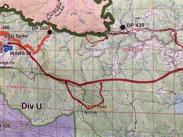
Information on Cameron Peak Fire Activity on Wednesday Morning 10142020
Related Incident:
Publication Type: News
Cameron Peak Fire Operations section is reporting the fire is on top of Signal Mountain and well established. There is a spot to the north firefighters are working on and they are making good progress so far.
It may be possible to launch a multi-mission aircraft (MMA) flight to get an aerial view of fire activity. We will post update IF and when that happens.
A map of the current situation where we have fire activity is attached. The fire is inside the hand-drawn solid red line west to east that includes the extension on the south.
This is a dynamic situation and the Rocky Mountain type 1 team is actively working with our partners.