
Cameron Peak Virtual Community Meeting Fri October 16 2020 at 730pm
Related Incident:
Publication Type: Announcement
Please join us tonight, Friday October 16, 2020, for a Virtual Community Meeting at 7:30 pm on the Cameron Peak Fire Facebook Page https://www.facebook.com/CameronPeakFire/
Fire Officials will provide updated information and answer questions.
Fri Oct Voluntary evacuations for Pinewood Reservoir to Flatiron Reservoir
Related Incident:
Publication Type: Announcement
The Larimer County Sheriff's Office has announced that Cameron Peak Fire officials have ordered Voluntary evacuations for Pinewood Reservoir to Flatiron Reservoir.
Voluntary evacuations are advised for residents and business occupants if they are concerned for their safety, feel they need additional time to exit the area, or have health conditions that may be aggravated by this incident.
You are encouraged to move livestock and pets out of the area and to prepare for mandatory evacuations.
For updates, text the word LCEVAC to 888777 from your cell phone. The Sheriff's Office will communicate information to that key word as needed. To view maps of the evacuation areas, please visit https://nocoalert.org/ Please do not call 9-1-1 unless you are in danger.
Mandatory evacuations Hwy 34 at Dam Store to just west of Soul Shine Rd
Related Incident:
Publication Type: Announcement
The Larimer County Sheriff's Office announced that Cameron Peak fire officials have ordered mandatory evacuations for Hwy. 34 from the Dam Store to just west of Soul Shine Road.
Residents and business occupants in the area should evacuate efforts to protect your home or business. Evacuating immediately not only supports your safety, but also allows emergency crews better access to the area.
For updates, text the word LCEVAC to 888777 from your cell phone. The Sheriff's office will communicate information to that key word as needed. For maps of the evacuation areas, please visit https://nocoalert.org/
Please do not call 9-1-1 unless you are in danger.
Friday Oct 16 OPS Update 1330
Related Incident:
Publication Type: Announcement
Crews are being pulled from Miller Creek, The Retreat, and Storm Mountain, due to extreme fire activity. They are reporting the fire is moving very fast.
Cameron Peak Fire Situacin Actual Viernes 16 de Octubre
Related Incident:
Publication Type: News
Cameron Peak Fire Situación Actual
Viernes, 16 de Octubre 2020 – 8:00 am
Rocky Mountain Type 1 Equipo de Gestión de Incidentes
Dan Dallas, Commandante del Incidente
Oficina de Información: 970-541-1008
Horas de operación: 8 a.m. to 8 p.m.
Correo electrónico: 2020.cameronpeak@firenet.gov
Situacio Actual: Ayer se utilizaron recursos aéreos para controlar la propagación del fuego hacia el este; y según lo permitan los vientos, hoy se volverán a utilizar los recursos aéreos. Las advertencias de bandera roja de hoy a sábado presentarán días desafiantes para los bomberos mientras se preparan para la posibilidad de un mayor avance del fuego. Se implementarán estrategias de extinción cuidadosamente planificadas dando prioridad a la seguridad de los bomberos y del público.
En el Branch I (usando la mapa) al norte y al este de la autopista 14 está en estado de vigilancia y patrulla. Los bomberos contuvieron un pequeño incendio en la División A / D. En la División F / L / R, ha comenzado el trabajo de reparación de supresión. Los problemas de seguridad incluyen árboles muertos por escarabajos y árboles debilitados por el fuego. A lo largo de la autopista 14 hasta el medio del incendio, los bomberos continúan patrullando y monitoreando las estructuras según lo permitan las preocupaciones de seguridad.
En Branch II, los equipos de la División T pudieron contener el fuego al sur de 44H Buckhorn Road en su mayor parte hoy. Aproximadamente un área de 1,000 acres que se quemó al norte de la 44H Buckhorn Road el miércoles fue trabajada por 3 grandes aviones cisterna y 4 helicópteros Tipo 1. La protección de la estructura a lo largo de 44H Buckhorn Road está en curso. El objetivo de hoy es continuar manteniendo el fuego al sur de 44H Buckhorn Road. Los equipos de la División V trabajaron a lo largo de la CR 27 construyendo una línea directa y una protección continua de la estructura. Operaciones está identificando y desarrollando líneas de contingencia primarias y secundarias al este más allá de CR 27 en preparación para el posible aumento en el comportamiento del fuego durante la Advertencia de Bandera Roja hoy y el sábado.
En Branch III es una nueva branch en la parte SO del incendio. En la División X, los bomberos y las camiones de fuego brindan protección estructural en áreas como The Retreat, Storm Mountain y Cedar Park. Los problemas de seguridad allí incluyen carreteras estrechas con curvas donde el acceso con motores grandes es difícil. Los administradores de incendios están explorando más hacia el sur para identificar líneas de contingencia adicionales, en caso de que sean necesarias. Los equipos de la División U continuaron trabajando alrededor del Rocky Mountain CSU cuando estaban a salvo. El área del incendio en el Rocky Mountain National Park en la División W será monitoreada desde tierra y aire, según lo permitan las condiciones. La División Z no tiene personal en este momento, ya que los administradores de incendios concentran la fuerza laboral en las necesidades de la interfaz urbana forestal hacia el este.
Un grupo de protección de estructuras está trabajando al norte del incendio proporcionando protección puntual en las áreas de Red Feather y Crystal Lakes según sea necesario. Otro grupo de protección de estructuras está trabajando al sur y al este del borde del fuego, evaluando las necesidades y estableciendo puntos de protección donde sea seguro hacerlo. Esto incluye las áreas y comunidades entre el crecimiento del fuego del miércoles y Glen Haven al sur. Los grupos de protección de estructuras están utilizando los camiones de fuego de sobretensión recientemente pedidos a medida que llegan para ayudar durante los eventos de viento y los períodos de advertencia de bandera roja.
Condiciones meteorológicas y de combustible: Hoy estamos esperando condiciones climáticas críticas de incendio con ráfagas de 40 a 45 mph del oeste y humedades en la adolescencia. Los vientos fuertes y las humedades bajas resultarán en un comportamiento de fuego activo que conducirá a posibles corridas de fuego de corona cuando el viento esté alineado con el terreno. Se emite una advertencia de bandera roja por el incendio que comienza a las 11 am del viernes. Se espera que la actividad de olas de montaña seguida de un frente frío fuerte y seco traiga vientos fuertes similares al evento de viento del miércoles. La Advertencia de Bandera Roja continuará hasta las 8 pm del sábado.
Cierres y evacuaciones: Se han realizado varias evacuaciones. Debido a las condiciones climáticas extremas, la situación puede cambiar rápidamente. Para actualizaciones, envíe un mensaje de texto con la palabra LCEVAC al 888777 desde su teléfono celular. La información de emergencia se enviará según sea necesario.
Evacuaciones y cierres de carreteras del condado de Larimer: https://nocoalert.org
Cierres de bosques nacionales Arapaho Roosevelt: https://www.fs.usda.gov/arp/alerts-notices/?aid=60887
Rocky Mountain National Park: https://www.nps.gov/romo/learn/fireinformation-and-regulations.htm
Restricciones temporales de vuelo (TFR): es ilegal operar un dron en el área del incendio. Los incendios forestales son una zona prohibida para los drones. Si vuela, no podemos. Siempre que se detecta un dron cerca del fuego, todos los aviones están conectados a tierra hasta que estemos seguros de que el dron está fuera del área. El uso de drones siempre está prohibido en los parques nacionales. Para obtener más información, visite http://knowbeforeyoufly.org.
Estadísticas de Incendios de Cameron
Tamaño: 167,153 acres
Contención: 56%
Personal total 1019
Ubicación: 2 millas SW de Red Feather Lakes, CO
Informe: 13 de agosto
Causa: Bajo investigación
Información sobre incendios: 970-541-1008 8 am to 8 pm
Correo electronico: 2020.cameronpeak@firenet.gov
Cameron Peak Fire Information Update Friday October 16
Related Incident:
Publication Type: News
Cameron Peak Fire Update
Friday, October 16, 2020 – 9:00 am
Rocky Mountain Type 1 Incident Management Team
Dan Dallas, Incident Commander
Information Office: 970-541-1008
Hours of Operation: 8 a.m. to 8 p.m.
Email: 2020.cameronpeak@firenet.gov
Current Situation:
Air resources were used yesterday to check the spread of the fire to the east; and as winds allow, air resources will be used again today. Red Flag Warnings today through Saturday will present challenging days for firefighters as they prepare for the possibility of further fire advancement. Carefully planned suppression strategies will be implemented while giving priority to the safety of firefighters and the public.
Branch I north and east of Highway 14 is in patrol and monitor status. Firefighters contained a small spot fire in Division A/D. In Division F/L/R, suppression repair work has begun. Safety issues include beetle-killed and fire-weakened trees. Along Highway 14 through the middle of the fire, firefighters continue to patrol and monitor structures as safety concerns allow.
In Branch II, crews in Division T were able to hold the fire south of 44H Buckhorn Road for the most part today. About a 1,000-acre area that burned north of the 44H Buckhorn Road on Wednesday was worked by 3 large airtankers and 4 Type 1 helicopters. Structure protection along 44H Buckhorn Road is ongoing. Today’s objective is to continue to keep the fire south of 44H Buckhorn Road. Crews in Division V worked along CR 27 building direct line and continuing structure protection. Operations is identifying and developing primary and secondary contingency lines to the east beyond CR 27 in preparation for the possible increase in fire behavior during the Red Flag Warning today and Saturday.
Branch III is a new branch in the SW portion of the fire. In Division X, firefighters and engines are providing structure protection in areas such as The Retreat, Storm Mountain, and Cedar Park. Safety issues there include narrow roads with switchbacks where access with large engines is difficult. Fire managers are scouting farther to the south to identify additional contingency lines, should they be needed. Crews in Division U continued to work around the CSU Rocky Mountain Campus when safe. The area of the fire in Rocky Mountain National Park in Division W will be monitored from the ground and air as conditions permit. Division Z is unstaffed at this time as fire managers focus the workforce on the wildland urban interface needs to the east.
A Structure Protection Group is working to the north of the fire providing point protection in the Red Feather and Crystal Lakes areas as needed. Another Structure Protection Group is working to the south and east of the fire edge, assessing needs and establishing point protection where it is safe to do so. This includes the areas and communities between Wednesday’s fire growth and Glen Haven to the south. The recently-ordered surge engines are being used by Structure Protection Groups as they arrive to assist during the wind events and Red Flag Warning periods.
Weather & Fuel Conditions: Today we are expecting critical fire weather conditions with gusts 40-45 mph out of the west and humidities in the teens. High winds and low humidities will result in active fire behavior leading to possible crown fire runs when the wind is in alignment with terrain. A Red Flag Warning is issued for the fire beginning at 11 am Friday. Mountain wave activity followed by a strong and dry cold front is expected to bring strong winds similar to Wednesday’s wind event. The Red Flag Warning will continue until 8 pm Saturday.
Evacuations and Closures: For updates, text the word LCEVAC to 888777 from your cell phone. Emergency information will be forwarded as needed. This is the best way to get information about the situation in your area.
Larimer County evacuations and road closures: https://nocoalert.org
Arapaho Roosevelt National Forests closures: https://www.fs.usda.gov/arp/alerts-notices/?aid=60887
Rocky Mountain National Park closures: https://www.nps.gov/romo/learn/fireinformation-and-regulations.htm
Temporary Flight Restriction (TRF): A TFR is in place over the Cameron Peak Fire. Wildfires are a No Drone Zone. If you fly, we can’t. Whenever a drone is spotted near the fire all aircraft are grounded until we can be sure the drone is clear of the area. For more information, visit http://knowbeforeyoufly.org.
Cameron Peak Fire Statistics:
Size: 167,153 acres
Containment: 56%
Total Personnel: 1,119
Location: 2 miles SW of Red Feather Lakes, CO
Reported: August 13, 2020
Cause: Under investigation
For More Information:
Information Office: 970-541-1008 8 am to 8 pm
Email: 2020.cameronpeak@firenet.gov
Cameron Peak Fire Smoke Outlook for Friday 1016
Related Incident:
Publication Type: Announcement
Smoke Outlook for 10/16 - 10/17
Northcentral Colorado - Cameron Peak Fire
Issued at: 2020-10-16 08:49 MDT
Special Statement
Red Flag Warning beginning today and in effect through
Saturday evening.
Fire Information
Cameron Peak is now 169,171 acres, Mullen Fire is 176,374
acres and Middle Fork Fire (west of Walden) is 19,848 acres.
The East Troublesome Fire (north of Parshall, Colorado) is more
than 3700 acres and actively burning this morning.
Smoke Information
Periods of moderate to heavy smoke from the Cameron Peak
wildfire can be expected in Larimer County on Thursday and
Friday, while occasional moderate to heavy smoke from the
East Troublesome wildfire could impact sections of Boulder
County, especially foothill locations, and perhaps around parts
of the Denver metro area on Thursday and Friday.
Important Message
- CDPHE has issued an Action Day for Fine Particulates
effective until 4:00 PM today.
https://www.colorado.gov/airquality/colo_smoke.aspx
- For Wyoming smoke information, please refer to the
Southeastern Wyoming Smoke Outlook
(https://fires.airfire.org/outlooks/SEWyoming)
Where Can I Send Donations
Related Incident:
Publication Type: Announcement
Where Can I Send Donations?
The outpouring of generosity from members of the public wishing to donate to the Cameron Peak Fire is truly overwhelming. The fire organization is completely self-sufficient with career, facilities, and all supplies that are needed. Donating to local organization is the most effective way to direct funds to the local communities most affected by this and future incidents. If you wish to give, please consider giving to your local Volunteer Fire Department/ Fire Protection District, a local charity of your choice, or one of the following:
The American Red Cross https://www.redcross.org/local/colorado/about-us/Locations/northern-colorado.html
Wildland Firefighter Foundation https://wffoundation.org/
United Way https://www.unitedway.org/local/united-states/colorado#
Know before you fly
Related Incident:
Publication Type: Announcement
Drones are fun, but potentially deadly in the wrong place.Hobbyist drones and firefighting aircraft don't mix. All authorized aircraft on an incident maintain radio communication with each other to safely coordinate their missions, but aerial firefighting flight crews have no way to communicate with drone operators. Aerial firefighting aircraft have no way to detect drones other than by seeing them, and visual detection is nearly impossible due to the small size of most drones. These factors make a mid-air collision with an unauthorized drone a distinct possibility.
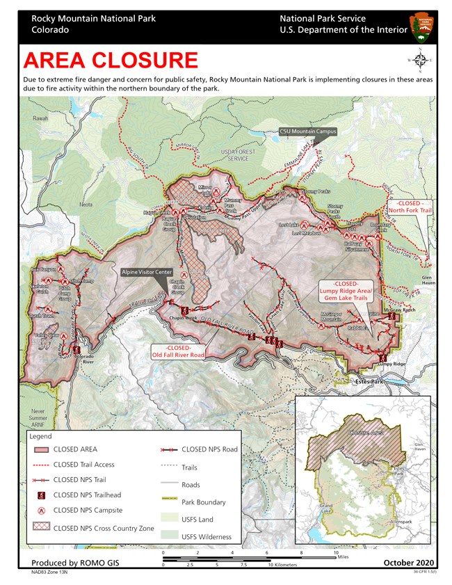
Update on Closures in Rocky Mountain National Park 1015
Related Incident:
Publication Type: Closures
Due to recent fire activity and weather forecasts on the Cameron Peak Fire, closure areas in Rocky Mountain National Park have expanded in the northern section of the park.
Additional closures implemented today include the Lawn Lake Trail and surrounding area. The Cow Creek Trail, the Black Canyon Trail, the Gem Lake Trail and the Lumpy Ridge area were closed on Sunday, October 11, as well as associated cross country zones. Area closures began on August 18 in the northwest section of the park and continued in the northeast area of the park on September 7. Currently the northern part of Rocky Mountain National Park is closed to all recreational access. Old Fall River Road remains closed. Trail Ridge Road and other areas of the park remain open.
Closures in Rocky Mountain National Park, including a map, can be found at:
https://www.nps.gov/romo/learn/fire-information-and-regulations.htm