
East Troublesome Firerelated Voluntary Evacuations Ordered
Related Incident:
Publication Type: Announcement
LCSO - Troublesome Fire Voluntary Evacuations advised
2020-10-22 13:05:37 MDT
This is the Larimer County Sheriff's Office with an emergency message. The East Troublesome Fire officials have ordered Voluntary evacuations for another portion of Estes Park with the north border of North St. Vrain Ave, west border of Curry Drive, south border of Acacia Drive, and east border of Fish Creek Road. Voluntary evacuations are advised for residents and business occupants if they are concerned for their safety, feel they need additional time to exit the area, or have health conditions that may be aggravated by this incident. You are encouraged to move livestock and pets out of the area and to prepare for mandatory evacuations. Please use Highway 34 eastbound to exit Estes Park. For questions about the evacuations, please call the Joint Information Center at 970-980-2500. For updates, text the word TFIRE to 888777 from your cell phone. We will communicate information to that key word as needed. To view a map of the evacuation areas, please visit nocoalert.org. Please do not call 9-1-1 unless you are in danger. Thank you.
East Troublesome Firerelated Mandatory Evacuations Ordered
Related Incident:
Publication Type: Announcement
This is the Larimer County Sheriff’s Office with upgraded evacuation information. The East Troublesome Fire officials have ordered Mandatory evacuations for the western part of Rocky Mountain National Park and much of the west side of the Estes Park area. This area includes the Rocky Mountain National Park west entrance, Moraine Park, Estes Park Campground, the southern part of Highway 7 north to Marys Lake, Peak View Drive including the Aerial Tramway and north to include Deer Ridge. Mandatory Evacuation have been ordered for residents and business occupants in the area due to immediate and imminent danger. Evacuate the area immediately and as quickly as possible. Do not delay leaving to gather belongings or make efforts to protect your home or business. Evacuating immediately not only supports your safety, but also allows emergency crews better access to the area. For questions about the evacuations, please call the Joint Information Center at 970-980-2500. For text updates, text the word TFIRE to 888777 from your cell phone. We will communicate information to that key word as needed. To view a map of the evacuation areas, please visit nocoalert.org. Please do not call 9-1-1 unless you are in danger.
Cameron Peak Fire Operations Update 1100 Air Support Grounded
Related Incident:
Publication Type: News
Operations Update 1100: Air support is grounded due to limited visibility, but operations are continuing as planned for today. There is no new significant fire activity to report at this time on the Cameron Peak Fire.
Cameron Peak Fire Update 10222020 900am
Related Incident:
Publication Type: News
Cameron Peak Fire Update
Thursday, October 22, 2020 – 9:00 am
Rocky Mountain Type 1 Incident Management Team
Dan Dallas, Incident Commander
Special Note: Fire suppression takes the cooperation of many people, agencies, and organizations all working hand in hand. Federal, State, and local agencies, as well as non-government organizations and private businesses are all working cooperatively to suppress Cameron Peak Fire. The excellent public support we are experiencing is much appreciated and makes our work all the more successful.
Current Situation:
During the majority of the day Wednesday, helicopters were able to slow fire progression with water and retardant drops as firefighters worked to construct, reinforce, and connect control lines along the southern edge of the fire. Crews continued to prep around structures and set up additional pumps and hoselays in The Retreat and Storm Mountain communities. Smoke from the East Troublesome fire near Granby, CO is now present over the Cameron Peak fire, and due to low visibility, air support was grounded in the late afternoon yesterday. Fire officials from Cameron Peak Fire are communicating with the East Troublesome fire managers and will work together as necessary.
Areas the fire previously burned through continue to smoke, smolder and occasionally show open flames. This is expected until there is a season-ending weather event. Most of these areas do not pose a threat to structures or the containment lines. Firefighters continue to monitor within the entire burned area and take action where values at risk may be vulnerable. The fire remains staffed at night; crews are patrolling control lines and monitoring nighttime fire behavior. Night crews implement suppression and structure protection efforts as needed.
Firefighters will be taking advantage of the change in weather this afternoon to secure the fire’s edge, and fire managers expect containment to increase over the next several days.
Forces in Branch I have been combined into Division D and continue monitoring fire behavior. The fire here remains inside secure containment lines. Division D is in patrol status, and six crews continue to remove equipment that is no longer needed. The power company continues to repair power infrastructure along Highway 14. Firefighters continue to monitor and mop-up hot spots; visible smoke from interior fuels burning is expected in the Bellaire Lake Campground area.
Excellent progress has been made in Branch II on the 44H Buckhorn and CR27 roads, where containment lines are nearly complete. Crews in Division T have completed the western portion of fireline near Boogie Woogie Way and continue to secure line in the area that burned north of 44H Buckhorn Road. Division V forces have been successful adding more containment line along CR27 and the southeast corner near Masonville. Aviation assisted Division U firefighters with water drops to reduce the interior heat of the Otter Road spot fire. Additional containment line has been constructed around the Otter Road spot fire, and crews continue to employ structure mitigation tactics.
Yesterday in Branch III, fire activity again increased across the southern perimeter. Firefighters in Division Y continue their mission of building direct line from CR27 west towards Cedar Park. Division X forces monitored the fire growth that occurred over the past several days from Bulwark Ridge towards CR43. Supervisors are scouting the best locations to construct direct line in the rough terrain to deflect fire from the Storm Mountain values at risk. Forces are working with aircraft on suppressing a thirty acre area of fire that crossed to the south of the North Fork Trail. Fire managers are evaluating the North Fork Trail as a key containment line and continue to focus on keeping the fire north of the trail. Night shift operations will continue work on the trail and take suppression actions as needed. The Incident Management Team continues to work with Rocky Mountain National Park fire managers to monitor fire activity in Divisions W and Z.
The Structure Group located at Pingree Park continues to monitor fire activity, mop-up, and protect against reburn potential around Pingree Park and the CSU Campus. A new Structure Group was designated to focus on values at risk along CR43. This allows other firefighting crews to focus on constructing line to secure the fire’s edge.
Weather & Fuel Conditions: The fire experienced relative humidity in the teen’s yesterday and last night. Near critical weather conditions will continue through the morning ahead of a cold front Thursday afternoon. Cold and windy weather is expected for the rest of the day with increased humidity. Active fire behavior is still present in the morning as the fuels are still dry but are expected to taper off in the afternoon.
Power Outages: For outage updates, visit https://www.pvrea.coop/outages to sign up for alerts and view outage maps; or contact Poudre Valley REA at 1-800-432-1012. Fire managers work closely with PVREA to monitor areas and turn power on when firelines are secure. Power is turned off within and near the fire for firefighter safety.
Evacuations and Closures: For updates, text the word LCEVAC to 888777 from your cell phone. Emergency information will be forwarded as needed. This is the best way to get information about the situation in your area. Call the Red Cross at 800-417-0495. Press #1 if you have been evacuated and need shelter. You can also visit http://cowyredcrossblog.org/cpf/for updates.
Larimer County evacuations and road closures: https://nocoalert.org
Arapaho and Roosevelt National Forests closures: https://www.fs.usda.gov/arp/alerts-notices/?aid=60887
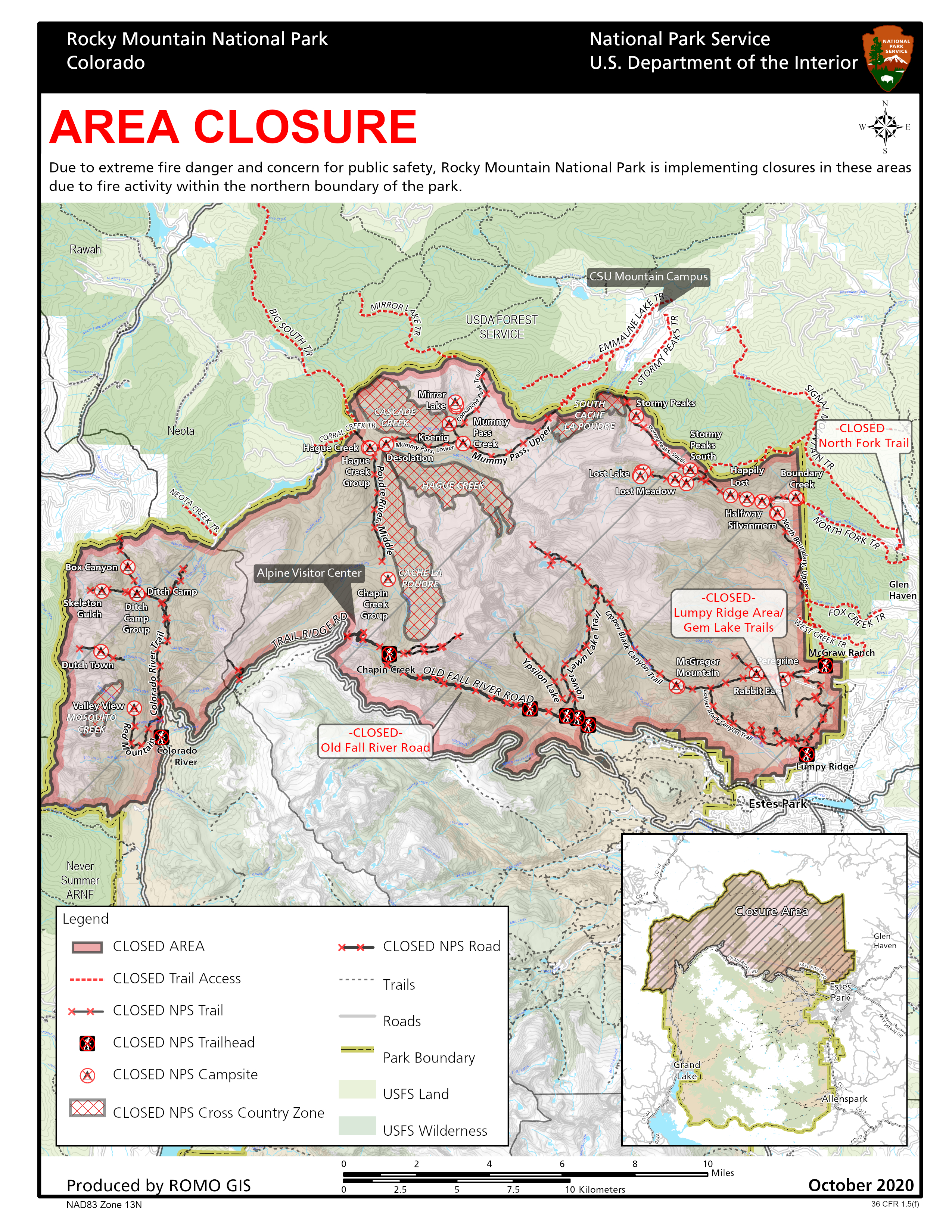
Rocky Mountain National Park closures: https://www.nps.gov/romo/learn/fireinformation-and-regulations.html
Temporary Flight Restriction (TRF): A TFR is in place over the Cameron Peak Fire. Wildfires are a No Drone Zone. If you fly, we can’t. Whenever a drone is spotted near the fire all aircraft are grounded until we can be sure the drone is clear of the area. For more information, visit http://knowbeforeyoufly.org.
Cameron Peak Fire Statistics:
Size: 206,977 acres
Containment: 55%
Total Personnel: 1,692
Location: 2 miles SW of Red Feather Lakes, CO
Reported: August 13, 2020
Cause: Under investigation
For More Information:
Fire Information Office: 970-541-1008 8 am to 8 pm
Email: 2020.cameronpeak@firenet.gov
InciWeb: https://inciweb.nwcg.gov/incident/6964
Facebook: https://www.facebook.com/CameronPeakFire/
YouTube: https://www.youtube.com/channel/UCPNA6qSJC2UYKz68rp9etvA
Larimer County Joint Info Center: (970) 980-2500
Rocky Mountain Type 1 Incident Management Team
Inciweb: inciweb.nwcg.gov/incident/6964/
Email: 2020.CameronPeak@Firenet.gov
Phone (7 am to 8 pm): 970-541-1008
West Side Of Rocky Mountain National Park Closed Due to Area Fires
Related Incident:
Publication Type: Closures
Rocky Mountain National Park News Release
October 21, 2020
For Immediate Release
Kyle Patterson 970-586-1363
West Side Of Rocky Mountain National Park Closed
Due To East Troublesome Creek Fire Growth Outside Of Park
The west side of Rocky Mountain National Park is closed to park visitors due to significant fire activity on the East Troublesome Creek Fire outside of the park. Grand Lake area residents are following evacuation orders to evacuate south on US 34 toward Granby. Trail Ridge Road is currently open for evacuation east bound if needed. There is low visibility reported due to smoke on Trail Ridge Road. Trail Ridge Road is closed west bound at Rainbow Curve. Travelers should be aware of smoke, wind, weather and fire conditions as fire activity is rapidly changing and road closures may be put in place quickly.
Information is currently being updated on the park’s website and social media. For further information about Rocky Mountain National Park, please visit www.nps.gov/romo or contact the park’s Information Office at 970-586-1206. The park's recorded Fire Information Line is (970) 586-1381.
Virtual Community Meeting at 730 pm on the Cameron Peak Fire Facebook Page
Related Incident:
Publication Type: Announcement
Please join us tonight, Wednesday, October 21, 2020, for a Virtual Community Meeting at 7:30 pm on the Cameron Peak Fire Facebook Page https://www.facebook.com/CameronPeakFire/
Fire Officials will provide updated information and answer questions.
Cameron Peak Fire Operations Update 530 pm Wednesday October 21
Related Incident:
Publication Type: News
Cameron Peak Fire Operations Update 5:30 pm, Wednesday, October 21
Due to progress made by firefighters today, containment will increase along the east side of CR 27. Progress continues along the remaining uncontained edge
Smoke from East Troublesome Fire is moving over Cameron Peak. Ash is falling at ICP.
All power lines east and south on the Otter Spot, where Division U is working,have been energized.
Evacuation Order Lifted for Lory State Park Area East of Rim Rock Valley
Related Incident:
Publication Type: Announcement
The Larimer County Sheriff has lifted the voluntary evacuations for Lory State Park as well as the area east of Rim Rock Valley Lane to Lakeview Drive at South Bay at Horsetooth. Residents in those two evacuation areas are no longer under any restrictions. Thank you for your cooperation during this large-scale event. Please do not call 9-1-1 unless you are in danger.
Evacuation Downgraded for CR 52E Rist Canyon from CR27 East to CR 27E
Related Incident:
Publication Type: Announcement
The Larimer County Sheriff has downgraded the evacuation status from mandatory to voluntary for County Road 52E (Rist Canyon Road) from County Road 27 east to County Road 27E. Please be sure to have proper identification to show residency in those areas that were mandatory evacs, as only residents will be allowed to enter. We ask that you use caution when driving through the area, as emergency crews are still present. To view a map of these changes, please visit nocoalert.org. Please do not call 911 unless you are in danger. Thank you.
Smoke From East Troublesome Fire Can Be Seen From Red Featehr Lakes
Related Incident:
Publication Type: News
We are getting questions about the increase in smoke that can be seen from the north end of the Cameron Peak Fire and on the Red Feather Lakes camera. This smoke is from the East Troublesome Fire which has become very active today. For more information on East Troublesome visit https://www.facebook.com/EastTroublesomeFire