
North Complex Evening Update September 6 2020
Related Incident:
Publication Type: News
Current Situation
Weather and Air Quality
Evacuations and Road Closures
Forest Closures
All trails, roads and campgrounds within the forest closure areas are closed.
North Complex Fire Morning Update September 6 2020
Related Incident:
Publication Type: News
Current Situation
The North Complex Fire was active last night, but no long-range spotting occurred as forecasted.
Weather and Air Quality
Evacuations and Road Closures
Forest Closures
All trails, roads and campgrounds within the forest closure areas are closed.
Smoke Outlook for the North Complex and Sheep Fires Sept 6 2020
Related Incident:
Publication Type: News
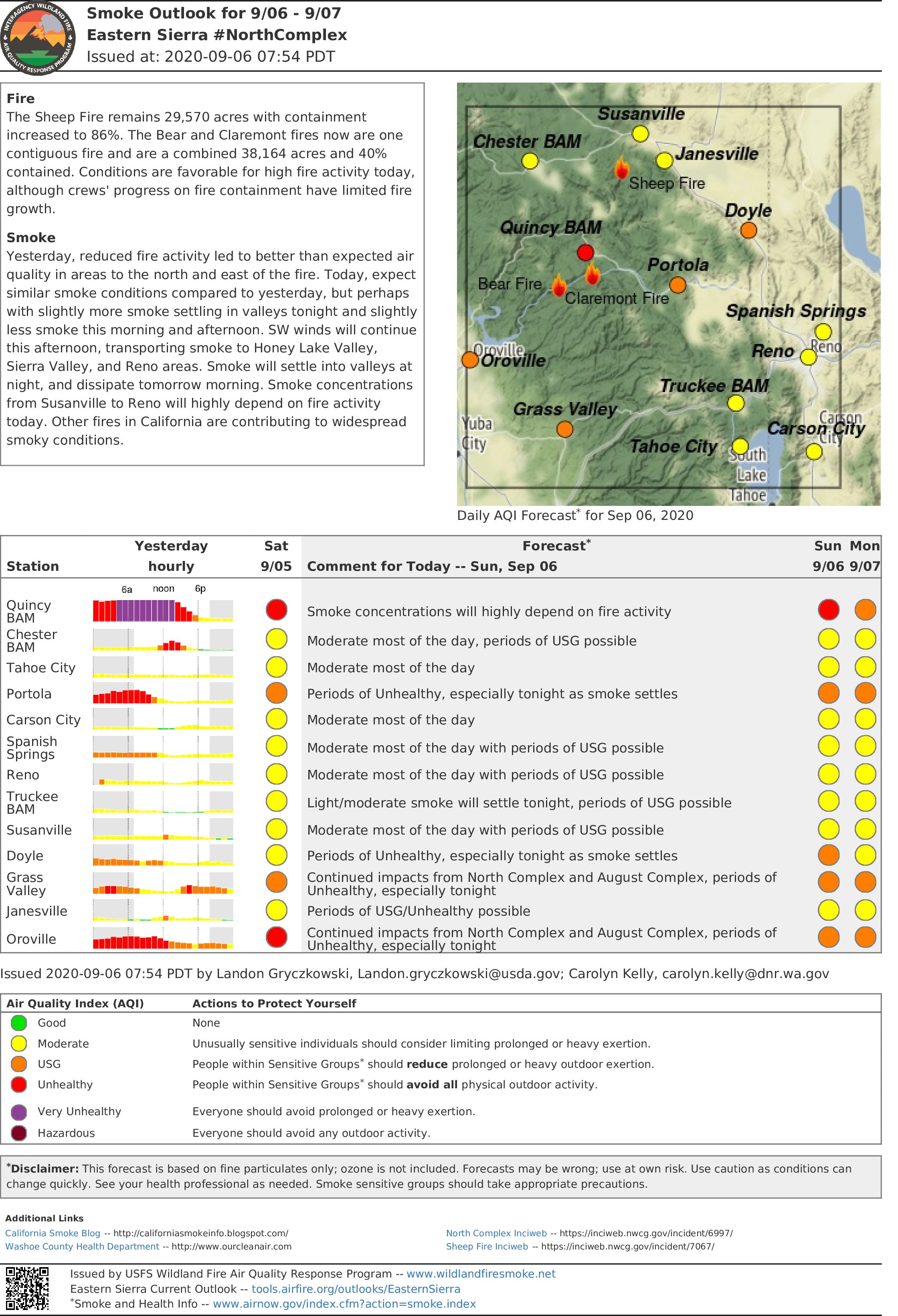
Fire
The Sheep Fire remains 29,570 acres with containment increased to 86%. The Bear and Claremont fires now are one contiguous fire and are a combined 38,164 acres and 40% contained. Conditions are favorable for high fire activity today, although crews' progress on fire containment have limited fire growth.
Smoke
Yesterday, reduced fire activity led to better than expected air quality in areas to the north and east of the fire. Today, expect similar smoke conditions compared to yesterday, but perhaps with slightly more smoke settling in valleys tonight and slightly less smoke this morning and afternoon. SW winds will continue this afternoon, transporting smoke to Honey Lake Valley, Sierra Valley, and Reno areas. Smoke will settle into valleys at night, and dissipate tomorrow morning. Smoke concentrations from Susanville to Reno will highly depend on fire activity today. Other fires in California are contributing to widespread smoky conditions.
North Complex Fire Evening Update September 5 2020
Related Incident:
Publication Type: News
Sheep Fire
The Sheep Fire is no longer a part of the North Complex, however firefighters are continuing to identify and extinguish hot spots and mop up. Currently, it is at 29,570 acres and 86% containment.
Current Situation
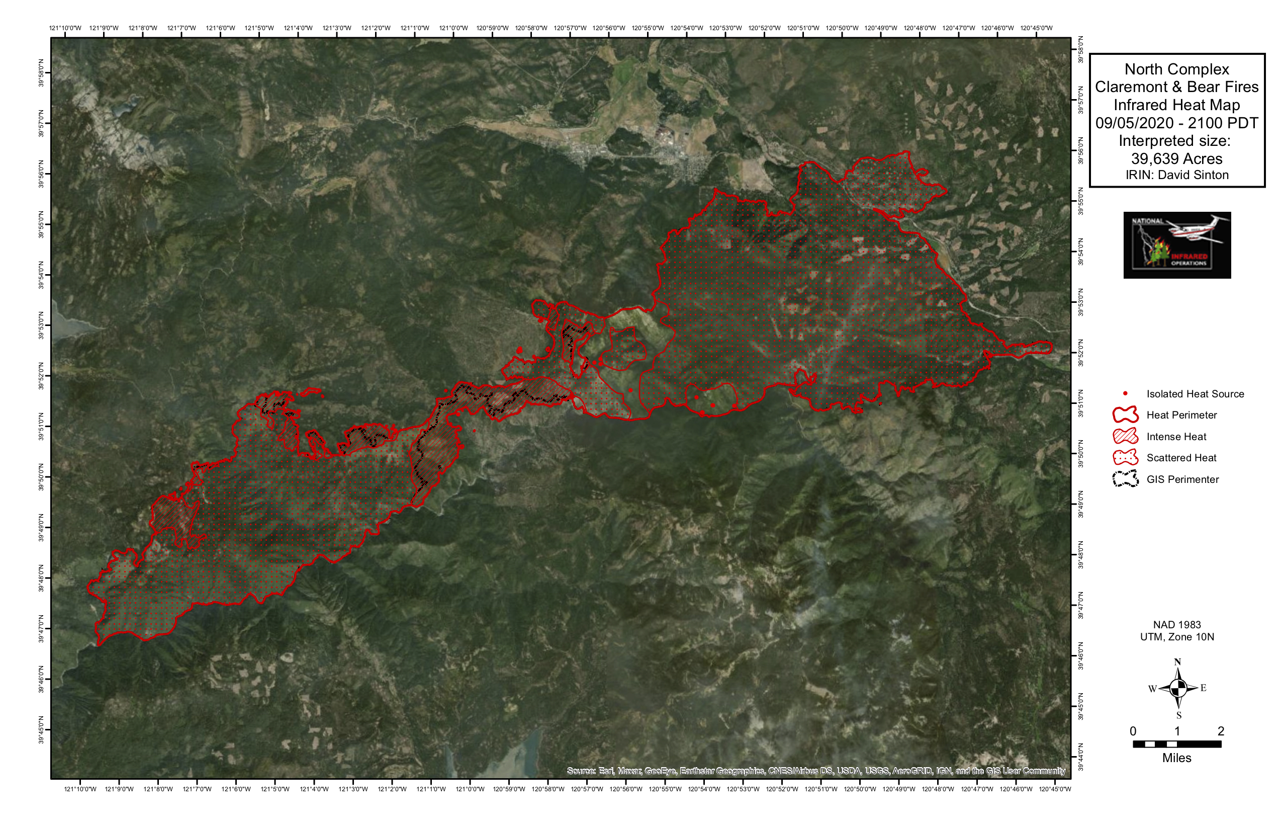
The North Complex Fire grew by approximately 900 acres Saturday, due to an inversion that lifted this afternoon increasing fire behavior. Smoke from interior pockets of the fire increased as the fire made an eastern run from Grizzly Creek in between the Bear and Claremont Fires toward the Claremont Fire. Some long-range spotting occurred, and crews are monitoring and patrolling.
Firefighters made good progress holding the fire within containment lines from the Middle Fork of the Feather River to the eastern flank of the fire. On the south side, containment line is holding well as crews continue mopping up. An infrared flight today revealed little heat along the southwestern edge of the fire.
On the northwestern side around Lookout Rock, fire behavior was calm enough for firefighters to directly engage with the flames. The fire is also holding well along Willow Creek as the fire moves toward constructed bulldozer lines.
Adverse winds prevented firefighters from conducting strategic firing operations between the edges of the Bear and Claremont fires, but are hopeful to continue tonight when the more favorable down canyon winds arrive.
Weather and Air Quality
Smoke from both the North Complex Fire and another wildfire west of Fresno drifted into the Quincy area, however air quality was a slight improvement from yesterday. Tonight, humidity recovery will be 20-75% depending on elevation, and temperatures will range from 49 to 75 degrees. Winds will shift from up slope and up drainage to down slope and down drainage at about 5 mph. The air quality generally will be smoky. For specific smoke impacts to your area, visit www.airnow.gov
USDA is an equal opportunity provider, employer, and lender
Evacuations
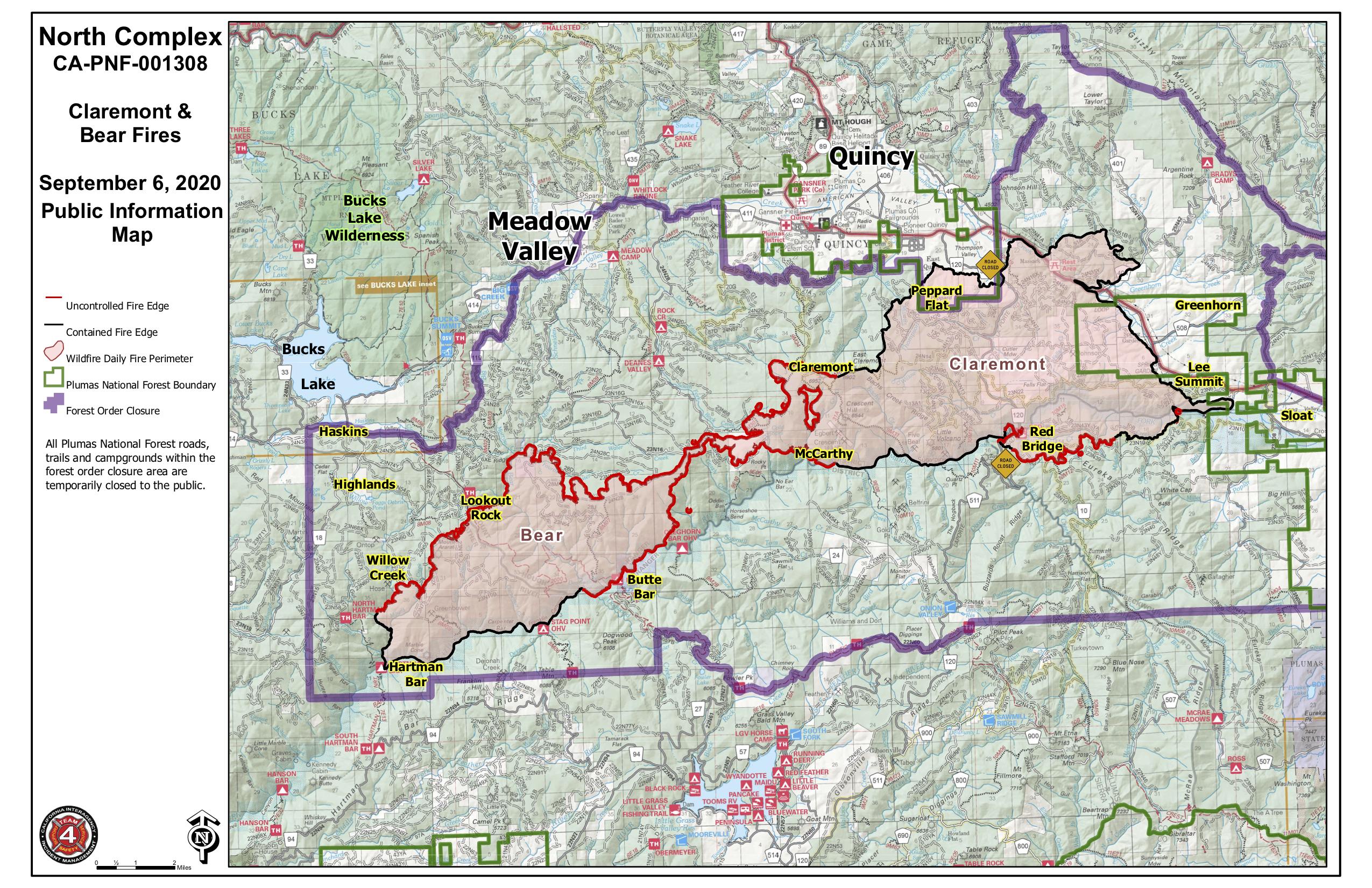
Evacuation Advisories were lifted by the Plumas County Sheriff at 2 p.m. for the communities of Greenhorn, Sloat and Cromberg. Advisories are still in place for Bucks Lake area, and Quincy LaPorte Road from Highway 70 south to Red Bridge. Please visit the Plumas County’s website for an interactive map: plumascounty.us/2721/North-Complex-Fire-Information.
Road Closures
Quincy LaPorte Road from Highway 70 south to Red Bridge is open to essential traffic only. The dirt portion of Peppard Flat Road is closed.
Smoke Outlook for the North Complex and Sheep Fires Sept 5 2020
Related Incident:
Publication Type: News
South West winds will continue this afternoon, transporting smoke to Honey Lake Valley, Sierra Valley, and Reno areas. Smoke will settle into valleys at night, including Oroville and Western Nevada valleys, and dissipate tomorrow morning. Other California fires are contributing to widespread smoky conditions.
Labor Day weekend recreation
Smoky conditions are likely at area lakes and reservoirs this weekend, especially overnight and through the morning as smoke settles. The best chance for better air quality is during the afternoon. Because of the widespread smoke, it difficult to identify those recreation areas that may have less smoke impact.
Full outlook report below.
North Complex Fire Morning Update September 5 2020
Related Incident:
Publication Type: News
Firefighters made good progress holding the fire within containment lines and firing operations Friday night, accomplishing their goal of bringing the Claremont Fire’s western edge to the Bear Fire’s eastern edge. The North Complex Fire is now one contiguous fire.
On the northern flank of the fire, firefighters’ plan today is to continue firing downslope heading south to eventually meet with the Middle Fork of the Feather River when conditions are favorable. On the northwestern edge around Lookout Rock and far below Ontop Mine, some small spotting did occur, however firefighters kept them under control. The plan to box off the fire along 23N19 and constructed bulldozer line is going according to plan.
On the southern flank of the fire, activity remained relatively calm. Most activity was in the Red Bridge area where additional smoke plumes may continue to be seen today. To the southwest, two additional miles of contingency line was also constructed along Forest Road 22N94 in case any other future spot fires take hold.
Weather and Air Quality
Afternoon humidity will be 10-15% and temperatures are expected to increase a few degrees to a high of 99. Winds this afternoon could reach gusts of 22 mph along ridgelines. The air quality generally will be smoky, dense at times, especially toward the Middle Fork drainage along the southern flank of the fire. For specific smoke impacts to your area, visit www.airnow.gov
Evacuations and Road Closures
Areas within the communities of Greenhorn, Sloat and Cromberg are still under Evacuation Advisories. Please visit the Plumas County’s interactive map for exact locations: plumascounty.us/2721/North-Complex-Fire-Information. For road closures, check the CalTrans quickmap.dot.ca.gov or 1-800-427-7623
North Complex Fire Evening Update September 4 2020
Related Incident:
Publication Type: News
The North Complex Fire increased approximately 350 acres today. The two fires left that are still actively burning on the complex are the Claremont Fire (24,561 acres, 50% containment) and the Bear Fire (12,569 acres, 26% containment).
Firefighters made good progress holding the fire within containment lines, progressed with firing operations and strengthening contingency lines. Some spotting did occur, however firefighters were able to quickly contain them. Fire behavior along the north side of the Middle Fork of the Feather River has been favorably backing down.
After a smoke inversion lifted today, fire behavior increased in a small area on the northern flank of the Bear Fire, but that also improved visibility for helicopters to make water drops to support the ground crews there.
Tonight, firefighters plan to continue strategic firing operations with the goal of bringing fire from the western corner of the Claremont Fire to the eastern corner of the Bear Fire.
Weather and Air Quality
The air quality generally will be smoky, dense at times, but otherwise clear. Humidity recoveries will be 20-65% depending on elevation, about a 10% drop in humidities from Thursday night. Winds will be switching direction from up to down drainages, and 5-10 mph on ridgelines. For specific smoke impacts to your area, visit www.airnow.gov
Forest Closures Plumas NF: www.fs.usda.gov/alerts/plumasp/alerts-notices Lassen NF: www.fs.usda.gov/alerts/lassen/alerts-notices
Evacuations and Road Closures
Areas within the communities of Greenhorn, Sloat and Cromberg are still under Evacuation Advisories. Please visit the Plumas County’s interactive map for exact locations. For road closures, check the CalTrans quickmap.dot.ca.gov or 1-800-427-7623
We are now publicly broadcasting our Cooperators and Planning meetings daily though Zoom (for troubleshooting, please direct message the Plumas NF on Facebook). Cooperators: https://usfs.zoomgov.com/j/1602646317 Planning: https://usfs.zoomgov.com/j/1600484186
California Interagency Incident Management Team 4 is implementing measures to prevent the spread of COVID-19 in both the fire area and surrounding communities.
Smoke Outlook for the North Complex and Sheep Fires Sept 4 2020
Related Incident:
Publication Type: News
Today's smoke report for the North Complex and Sheep Fires:
Southwest winds today will be slightly stronger than yesterday, transporting smoke further to the North and East, causing slightly worse air quality tonight in the Honey Lake Valley, Sierra Valley, and Reno areas.
Smoke will settle into valleys at night, including Western Nevada valleys from the Black Rock Desert to Fallon, and dissipate tomorrow morning. The Quincy area may see some improvement this afternoon as smoke lifts, but heavy smoke will return tonight, similar to last night. The Oroville area will continue to see light smoke at night as smoke travels down the Middle Fork Feather River valley.
Smoke from the Slink Fire will also impact areas from Carson City to Reno.
Full outlook report below in article related file.
Morning update for the North Complex for Sept 4 2020
Related Incident:
Publication Type: News
The North Complex Fire increased approximately 100 acres overnight, with a combined acreage of 36,624 at 42% containment. The two fires that are actively burning are the Claremont Fire (24,330 acres, 49% containment) and the Bear Fire (12,154 acres, 29% containment).
California Interagency Incident Management Team 4 assumed command of the North Complex on Thursday.
Last night the fire held well within containment lines and firefighters made good progress gaining approximately one-half mile of firing operations to bring the Claremont Fire’s west edge toward the Bear Fire’s eastern edge. This area is where most of the active fire activity is and remains the priority for placing resources. Personnel patrolled containment line throughout the fire’s perimeter overnight, and continued to gain more depth in mopping up.
Today a smoke inversion is expected which will decrease smoke column activity, however it may lift in the afternoon which might increase fire behavior. With clear skies, aircraft will continue to support ground crews.
To continue strategic firing operations in inaccessible terrain, drones might be used to carry out tactical ignitions when conditions permit.
For a more in-depth description on tactical operations of the North Complex Fire, please watch our latest operational video updates at: www.facebook.com/USFSPlumas
Resources: 1,733 total personnel
28 dozers, 112 engines, 17 hand crews, 9 helicopters, 24 water tenders, 21 other heavy equipment.
Weather
Southwest winds will increase today, becoming gusty this afternoon and evening. The air also will become drier with humidities at 11-21% and gusty winds slightly increasing speed up to 22 miles per hour.
Air Quality
Generally smoky throughout the day, dense at times, but otherwise sunny. A general up-river, up-drainage airflow may push smoke to the north and east. For specific smoke impacts to your area, visit www.airnow.gov
Evacuations
An evacuation Advisory is still in place in Plumas County from Quincy La Porte Road between Thompson Creek and Red Bridge; Greenhorn; Spring Garden; and Highway 70 from Massack Rest Area to Spring Garden. For an interactive map, visit: plumascounty.us/2721/North-Complex-Fire-Information
Forest Closures: Plumas NF: www.fs.usda.gov/alerts/plumasp/alerts-notices Lassen NF: www.fs.usda.gov/alerts/lassen/alerts-notices
Emergency Alerts: Plumas: www.plumascounty.us/ Lassen: www.lassencounty.org/dept/sheriffs-office/sheriffs-office Road Closures: CalTrans quickmap.dot.ca.gov or 1-800-427-7623 Community boards: find out where daily updated fire informational boards are by visiting https://arcg.is/18vnSe
California Interagency Incident Management Team 4 is implementing measures to prevent the spread of COVID-19 in both the fire area and surrounding communities.
North Complex Evening Update for Sept 3 2020
Related Incident:
Publication Type: News
Resources: 28 dozers, 112 engines, 17 hand crews, 9 helicopters, 24 water tenders, 21 other heavy equipment – North Complex Only
Community boards: Fire staff are posting information daily throughout the communities impacted by the North Complex fires. Find out where by visiting https://arcg.is/18vnSe
Sheep Fire: The Sheep Fire remains at 29,750 acres and 71% contained. The fire stayed inside established containment lines today. Crews focused on working around remaining interior hot spots, which continue to ignite and burn, and to strengthen established lines ahead of the weekend's predicted warmer temperatures and higher winds. This will be the final evening update for the Sheep Fire.
North Complex: The North Complex consists of multiple lightning-caused fires (August 17, 2020) on the Plumas and Lassen National Forests.
California Interagency Incident Management Team 4 assumed command of the North Complex at 6 p.m.
On the Claremont Fire, crews focused on building fireline around the pair of slopovers west of Claremont Trail. Firefighters got lines and hose lays around the northernmost of the two slops while making good progress on the south slop. Personnel will remain engaged overnight and work to continue today’s progress.
Part of the plan for containment is connecting the Claremont and Bear fires via Forest road systems and dozer lines and crews were able to start tactical firing operations heading west from the Claremont along Forest Road 23N70Y as part of the plan. Firing operations only take place when personnel, terrain and weather align and is used to solidify existing containment lines.
The rest of the fire remained quiet as crews worked to mop up any lingering hot spots and gain depth in containment lines.
The Bear Fire continued its push north into the Fourth Creek drainage and east toward Pigeon Roost Creek with prevailing westerly winds. The fire remains checked up in Willow Creek to the west and the Middle Fork of the Feather River to the south. Firefighters worked to scout areas to build direct line where terrain and fire behavior allow.
Weather: Increasing southwest winds are forecasted for the coming days along with higher temperatures and lower humidity. A general up-river, up-drain flow will push smoke to the north and east.
Air Quality: Smoke will settle into valleys at night and dissipate Friday morning. The continued southwest flow could bring additional smoke from other fires west of the Central Valley. More information at www.airnow.gov
Closures/Evacuation: Plumas County – Quincy La Porte Road between Thompson Creek and Red Bridge; Greenhorn; Spring Garden; and Highway 70 from Massack Rest Area to Spring Garden are in advisory status and residents have been allowed to return to their homes.
More information can be found at https://plumascounty.us/2721/North-Complex-Fire-Information
Plumas National Forest: For information on campground closures and Forest Closures in relation to the Bear, Sheep and Claremont fires, go to: https://www.fs.usda.gov/alerts/plumasp/alerts-notices.
Lassen County – The dirt portion of Gold Run Road remains closed and the dirt portion of Wingfield Road is open to residents only. The Bureau of Land Management’s Eagle Lake Field Office has reopened the Dodge Reservoir Campground and the Bizz Johnson National Recreation Trail in Lassen County.
Lassen National Forest: Forest Service Road 29N03, Roxie Peconom and Goumaz campgrounds are closed. For further information on closures, including Forest Closures in relation to the Sheep Fire, go to: https://www.fs.usda.gov/alerts/lassen/alerts-notices
For text notifications about emergency alerts, sign up for the Plumas and Lassen County’s CodeRed Emergency Alert System from their respective websites: Plumas—https://www.plumascounty.us/; Lassen —http://www.lassencounty.org/dept/sheriffs-office/sheriffs-office
Visit CalTrans at quickmap.dot.ca.gov or call 1-800-427-7623 for the latest maps and information of road closures in your area.
COVID-19: California Interagency Incident Management Team 4 has implemented precautionary measures to prevent the spread of COVID-19 in both the fire area and surrounding communities.