
EVACUATION INFORMATION UPDATEPlumas County Sheriff 82820
Related Incident:
Publication Type: Announcement
EVACUATION AND ROAD CLOSURE INFORMATION
MANDATORY EVACUATION ORDERS remain in effect for the following areas:
-
QUINCY LAPORTE ROAD from Thompson Creek south to Red Bridge (Middle Fork of the Feather River.
-
Highway 70: From Massack Rest Area to Spring Garden
-
COMMUNITY OF SPRING GARDEN
-
COMMUNITY OF GREENHORN RANCH
EVACUATION ADVISORIES ARE IN EFFECT for the following areas:
-
COMMUNITY OF SLOAT
-
COMMUNITY OF CROMBERG
-
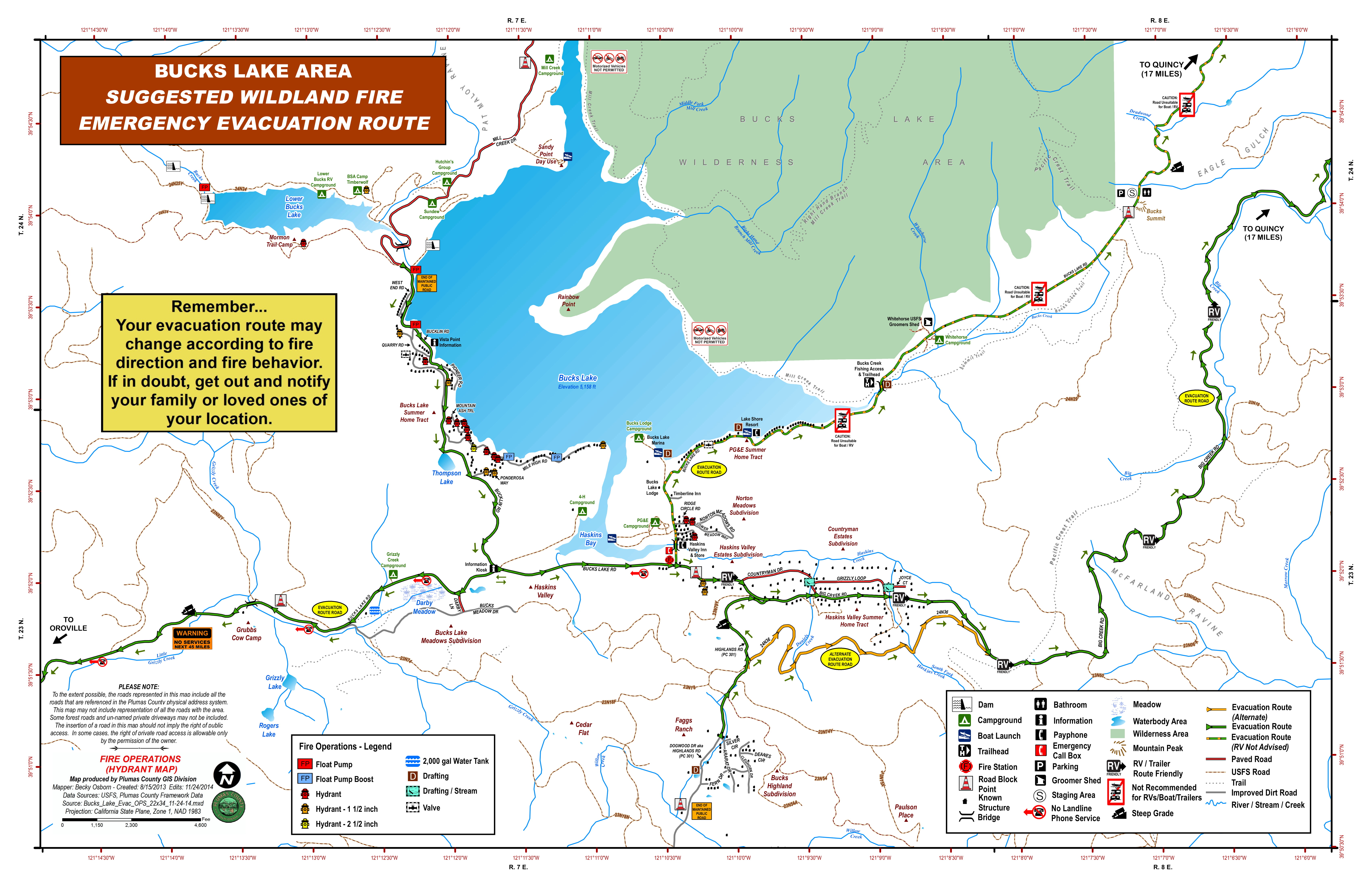
Bucks Lake: Big Creek Road from the Mount Ararat Road to Bucklin Road (to include Countryman
Drive and Grizzly Loop) and Bucks Lake Road south of the Old Transfer Station Rd (Timberline Lodge)
extending to the area of the On Top Mine to include the Bucks Highlands area.
-
Quincy LaPorte Road from Highway 70 south to Thompson Creek.
-
MODIFIED: Quincy LaPorte Road from Quincy LaPorte Road & Highway 70 to Massack.
o Highway 70 at Chandler Road, east to the west side of the Massack Rest Area.
ROAD CLOSURES AND INFORMATION
-
Quincy LaPorte Road from Hwy 70 to Thompson Creek is open to RESIDENTS ONLY
-
Quincy LaPorte Road from Thompson Creek to Red Bridge is CLOSED
-
Peppard Flat Road (The dirt portion) is CLOSED
NOTABLE CHANGES The below areas are being REMOVED from ADVISORY STATUS
-
NEW EAST QUINCY, south of Lee Road from Radio Hill Road east.
o To include EAST QUINCY, south of Highway 70 between Millcreek (to include Mill CreekRoad and Forest View Drive) extending east to Quincy LaPorte Road.
-
NEW Chandler Road (east end), from Highway 70 east to Carol Lane East. SHELTER INFORMATION
None at this time; however, if you need assistance contact Plumas Co. Social Services at 283-6350
If you need assistance with animals contact Plumas County Animal Services at 283-3673. Large animals/livestock can also be accommodated.
THE ABOVE INFORMATION IS SUBJECT TO CHANGE AT ANY TIME
Smoke Outlook 82820
Related Incident:
Publication Type: News
See related file for today's SMOKE OUTLOOK
North Complex AM UPDATE 82820
Related Incident:
Publication Type: News
North Complex Resources: 39 dozers, 171 engines, 21 hand crews, 15 helicopters, 34 water tenders, 10 other heavy equipment Community boards: Fire staff are posting information daily throughout the community. Find out where: https://arcg.is/18vnSe.
Current Situation on the North Complex: The North Complex consists of multiple lightning-caused fires (August 17, 2020) on the Plumas and Lassen National Forests.
As other fires in the North Complex increase in containment, focus on the Bear Fire will ramp up and additional resources are being assigned to that fire. Priority has shifted to completing firelines to keep the fire out of the Willow Creek drainage and protect the Haskins Valley and Bucks Lake areas. Crews are nearing completion on dozer line along the western edge of the Claremont Fire and have hose lays in place near Claremont Trail, but the priority sections remain to the east. Crews continue to construct fireline, improve existing lines and mop up today, in addition to improving roads to contain the southern, western and northern sections of the Sheep Fire. Fire activity yesterday was mild as compared to previous days, despite isolated thunderstorms.
Weather: Generally east winds move in to the area today and will provide relief from the smoke for portions of the communities effected by the North Complex. There is a possibility of thunderstorms throughout the fire areas but the chance is minimal. As the temperature increases and humidity decreases throughout the day, fire behavior and smoke production will increase into the afternoon.
Air Quality: East winds are expected through the afternoon continuing to move smoke to the west and south. Smoke from the North Complex that settled over the area last night is forecast to dissipate this afternoon but might return to the region again this evening. Impacts are again seen closet to the fire. Quincy and Susanville continue to be hardest hit. The Reno/Tahoe area can continue to expect decreased levels of air quality as smoke lingers in the area.
Closures/Evacuations: This morning, the Mandatory Evacuation Orders for Dirt Wingfield Road to Baxter Creek Road but not including Baxter Creek Road, and Elysian Valley Road, Indians Road, and all connecting roads were downgraded to an Evacuation Warning. Quincy La Porte Road from Highway 70 to Thompson Creek Road is open to residents only. Quincy La Porte Road from Highway 70 to Red Bridge and Peppard Flat Road (dirt portion) remain closed. The Pacific Crest Trail from Onion Valley to Bucks Summit remains closed as does Thompson Creek Road (Forest Road 24N26) and Red Bridge Campground.
Mandatory Evacuations are in place for the following locations according to the Plumas County Sheriff’s Office: Quincy Laporte Road from Thompson Creek south to Red Bridge (Middle fork of the Feather River.); Highway 70: From Massack to Spring Garden; Spring Garden Community; Greenhorn Ranch Community. Evacuation Advisories are in effect for the following: Bucks Lake Big Creek Road from the Mount Ararat Road to Bucklin Road (to include Countryman Drive and Grizzly Loop) and Bucks Lake Road south of the Old Transfer Station Rd (Timberline Lodge) extending to the area of the On Top Mine to include the Bucks Highlands area; Quincy Laporte Road from Highway 70 south to Thompson Creek; Quincy Laporte Road from Highway to Massack; East Quincy, south of Lee Road from Radio Hill Road east. (to include East Quincy, south of Highway 70 between Mill Creek (to include mill Creek Road and Forest View Drive) extending east to Quincy Laporte Road; Chandler Road (east end) from Highway 70 east to Carol Lane East; Sloat Community; Cromberg Community.
An evacuation center remains in place for Susanville at the Lassen Community College Dormitories. Large animals can be housed at the Lassen County Fairgrounds. For immediate text notifications about emergency alerts, residents can sign up for the Plumas and Lassen County’s CodeRed Emergency Alert System from their respective websites: Plumas—https://www.plumascounty.us/; Lassen —http://www.lassencounty.org/dept/sheriffs-office/sheriffs-office
COVID-19: California Interagency Incident Management Team 1 has implemented precautionary measures to prevent the spread of COVID-19 in both fire the surrounding communities.
North Complex Fires: Claremont Fire – https://inciweb.nwcg.gov/incident/6996/ Bear Fire – https://inciweb.nwcg.gov/incident/7025/ Sheep Fire – https://inciweb.nwcg.gov/incident/7067/ Forest Closures: https://fs.usda.gov/alerts/plumas/alerts-notices
North Complex PM UPDATE 8272020
Related Incident:
Publication Type: News
AUGUST 27, 2020 8 pm
![]()
North Complex Evening Update
North Complex Resources: 39 dozers, 171 engines, 21 hand crews, 15 helicopters, 34 water tenders, 10 other heavy equipmentCommunity boards: Fire staff are posting information daily throughout the community. Find out where: https://arcg.is/18vnSe.
Current Situation on the North Complex: The North Complex consists of multiple lightning-caused fires (August 17, 2020) on the Plumas and Lassen National Forests.
Today, crews continued to strengthen and mop up existing firelines on the Sheep Fire. Though there were some isolated thunderstorms, fire activity was mild as compared to previous days.
Diligent work by firefighters produced greater containment on the Claremont Fire and it sits at 47% and 20,697 acres. Crews faced a wind shift from previous days and the westerly flow posed containment issues on the far southeast corner of the fire where personnel picked up several spot fires in the area of Harrison Flat. Good progress was made across the northern section of the Bear Fire where crews neared completion on a dozer line running east to west utilizing forest roads. Crews also are working to build indirect line to the west.
Weather: Hotter and drier conditions and a wind shift brought increased fire activity over much of the fire area. Tomorrow, there is a chance for scattered thunderstorms, increased winds, and erratic fire behavior.
Air Quality: Quincy and Susanville can expect continued higher levels of smoke while other areas near the North Complex should see moderate and “unhealthy for sensitive groups” levels of smoke. Widespread haze continues to linger but improved mixing heights should help dissipate some of the smoke.
Closures/Evacuations: This morning, the Mandatory Evacuation Orders for Dirt Wingfield Road to Baxter Creek Road but not including Baxter Creek Road, and Elysian Valley Road, Indians Road, and all connecting roads were downgraded to an Evacuation Warning. Quincy La Porte Road from Highway 70 to Thompson Creek Road is open to residents only. Quincy La Porte Road from Highway 70 to Red Bridge and Peppard Flat Road (dirt portion) remain closed. The Pacific Crest Trail from Onion Valley to Bucks Summit remains closed as does Thompson Creek Road (Forest Road 24N26) and Red Bridge Campground.
Mandatory Evacuations are in place for the following locations according to the Plumas County Sheriff’s Office: Quincy Laporte Road from Thompson Creek south to Red Bridge (Middle fork of the Feather River.); Highway 70: From Massack to Spring Garden; Spring Garden Community; Greenhorn Ranch Community. Evacuation Advisories are in effect for the following: Bucks Lake Big Creek Road from the Mount Ararat Road to Bucklin Road (to include Countryman Drive and Grizzly Loop) and Bucks Lake Road south of the Old Transfer Station Rd (Timberline Lodge) extending to the area of the On Top Mine to include the Bucks Highlands area; Quincy Laporte Road from Highway 70 south to Thompson Creek; Quincy Laporte Road from Highway to Massack; East Quincy, south of Lee Road from Radio Hill Road east. (to include East Quincy, south of Highway 70 between Mill Creek (to include mill Creek Road and Forest View Drive) extending east to Quincy Laporte Road; Chandler Road (east end) from Highway 70 east to Carol Lane East; Sloat Community; Cromberg Community.
An evacuation center remains in place for Susanville at the Lassen Community College Dormitories. Large animals can be housed at the Lassen County Fairgrounds. For immediate text notifications about emergency alerts, residents can sign up for the Plumas and Lassen County’s CodeRed Emergency Alert System from their respective websites: Plumas—https://www.plumascounty.us/; Lassen —http://www.lassencounty.org/dept/sheriffs-office/sheriffs-office
COVID-19: California Interagency Incident Management Team 1 has implemented precautionary measures to prevent the spread of COVID-19 in both fire the surrounding communities.
North Complex Fires:
Claremont Fire – https://inciweb.nwcg.gov/incident/6996/
Bear Fire – https://inciweb.nwcg.gov/incident/7025/
Smoke Outlook UPDATE 8272020
Related Incident:
Publication Type: News
See attached file for today SMOKE OUTLOOK
EVACUATION INFORMATION UPDATE Plumas County Sheriff 8272020 at 10 am
Related Incident:
Publication Type: Announcement
Claremont Fire
EVACUATION AND ROAD CLOSURE INFORMATION
MANDATORY EVACUATION ORDERS have been issued for the following areas:
• QUINCY LAPORTE ROAD from Thompson Creek south to Red Bridge (Middle Fork of the Feather River.
• Highway 70: From Massack Rest Area to Spring Garden
• COMMUNITY OF SPRING GARDEN
• COMMUNITY OF GREENHORN RANCH
EVACUATION ADVISORIES ARE IN EFFECT for the following areas:
• EAST QUINCY, south of Lee Road from Radio Hill Road east.
o To include EAST QUINCY, south of Highway 70 between Millcreek (to include Mill Creek Road and Forest View Drive) extending east to Quincy LaPorte Road.
• Chandler Road (east e11)d, from Highway 70 east to Carol Lane East.
• COMMUNITY OF SLOAT
• COMMUNITY OF CROMBERG
• Bucks Lake: Big Creek Road from the Mount Ararat Road to Bucklin Road (to include Countryman Drive and Grizzly Loop) and Bucks Lake Road south of the Old Transfer Station Rd (Timberline Lodge) extending to the area of the On Top Mine to include the BucksHighlands area.
• Quincy LaPorte Road from Highway 70 south to Thompson Creek.
• Quincy LaPorte Road from Quincy LaPorte Road & Highway 70 to Massack.
ROAD CLOSURES AND INFORMATION
• NEW Quincy LaPorte Road fro1n Hwy 70 to Tho1npson Creek is open to RESIDENTS ONLY
• Quincy LaPorte Road fro1n Tho1npson Creek to Red Bridge is CLOSED
• Peppard Flat Road (The dirt portion) is CLOSED
SHELTER INFORMATION
None at this time; however, we are prepared to open one at any time.
If you need assistance with animals, contact Plumas County Animal Services at 283-3673. Large animals/livestock can also be accommodated.
THE ABOVE INFORMATION IS SUBJECT TO CHANGE AT ANY TIME
EVACUATION INFORMATION UPDATE Lassen County Sheriff 8272020 930 AM
Related Incident:
Publication Type: Announcement
UPDATED PRESS RELEASE 8/27/2020 9:30AM SHEEP (NORTH COMPLEX) FIRE EVACUATION ORDERS DOWNGRADED FOR SOME AREAS Effective Thursday, August 27th at 9:30am, the following Mandatory Evacuation Orders have been downgraded to an Evacuation Warning: • Dirt Wingfield Road to Baxter Creek Road but not including Baxter Creek Road. • Elysian Valley Road, Indians Road, and all connecting roads. The following are instructions for residents returning home: 1. Residents should be aware that changing conditions in fire activity may cause this area to escalate back to a mandatory evacuation order at any time. If you have evacuated large animals and vehicles, please keep them out of the area. 2. Please use caution, reduce your speed, drive with your headlights on and yield to emergency personnel.
3. Just because the flames are out doesn’t mean the danger is over. Damaged trees, structural damage, and flash flooding are just some of the dangers that exist after a wildfire. DO NOT put yourself or your loved ones in danger by exploring. Expect to see hotspots for some time. Do not call 911 to report unless there is an immediate threat to life or property. The following Mandatory Evacuation Orders are in effect for the following areas: • Baxter Creek Road. • Wingfield Road at Baxter Creek Road to where the pavement begins at Peter Lassen’s Grave. • Cheney Creek Road and all roads accessed by Cheney Creek Road. The following Evacuation Warnings are in effect for the following areas: • Gem Drive, Pearl Circle, and all roads accessed by those roads. • Richmond Road and all roads accessed by Richmond Road from Hwy 395 to Pearl Circle. but NOT Cheney Creek Road, Baxter Creek Road, or the closed portion of Wingfield Road which are still under Mandatory Evacuation Order. • Wingfield Road from Richmond Road to Peter Lassen’s Grave. • Sunnyside Road from Hwy 395 to County Road A-3. • Everything West of Highway 395 from Richmond Road East at the intersection by Susanville Ford to Janesville Grade and all roads in between. • Main Street Janesville from Highway 395 to Janesville Grade and all roads accessed by Main Street Janesville. • Bass Hill Road. • Wingfield Road East from Bass Hill Road to Wingfield Road East including Elysian Valley Road, Indians Road and all connecting roads but NOT Baxter Creek Road. Road Closures: • Cheney Creek Road. • Wingfield Road at Baxter Creek Road to where the pavement begins at Peter Lassen’s Grave. • Elysian Valley Road. • Forest Service Road 29N03 by Roxie Peconom Campground. For questions about whether your address is under mandatory, warning, or lifted status, please call (530)316-4487. Dispatch has been flooded with calls that can better be answered by someone who isn't also trying to answer emergency c
People under order need to leave immediately. People under warning need to prepare to leave soon. Please use caution, drive with your headlights on and yield to emergency personnel. Residents needing assistance evacuating are asked to call the dispatch center at (530)257-6121. If you need shelter, go to the Lassen Community College Dormitories. Large animals can be housed at the Lassen County Fairgrounds. Go to the Fair office on Russell Drive first before 5pm. After 5pm, call the Emergency Shelter Line at (530)250-9088. Liability, feed, and care of large animals is the sole responsibility of the animal’s owner. Deputies will be going door to door to make notification.
North Complex AM UPDATE 8272020
Related Incident:
Publication Type: News
AUGUST 27, 2020 8 am
North Complex Morning Update
Note: We are providing three updates for the complex – Sheep, Claremont and Bear, and North Complex summary.North Complex Resources: 31 dozers, 169 engines, 17 hand crews, 15 helicopters, 33 water tenders
Current Situation on the North Complex: The North Complex consists of multiple lightning-caused fires (August 17, 2020) on the Plumas and Lassen National Forests.
Crews worked throughout the night building new fireline along the Sheep Fire and strengthening and mopping up existing line. Firefighters were able to complete dozer line south and southwest on that flank, towards the heel of the fire in the area of Indicator Peak. Today, crews will strengthen and mop up all fire lines while continuing to provide structure protection.
Firefighters made good progress yet again and containment on the Claremont Fire is up to 30% as crews work to pinch the fire off and steer it into manageable terrain. With protection of local communities one of the top priorities, personnel are working to button up the eastern section of the fire as winds shift today and become more westerly and humidity drops. The Bear fire remains active. Firefighters are working to build line north of the fire to prevent any push toward Quincy.
Weather: Today brings a change in the weather pattern as hotter, drier conditions move in. With lower humidity and increased heat comes the potential for increased fire activity and the likelihood residents and visitors will see larger smoke columns than in recent days. Humidities will dip into the 15-25% range, winds will remain relatively calm and be west in the morning, shifting to northwest.
Air Quality: Quincy and Susanville can expect continued higher levels of smoke while other areas near the North Complex should see moderate and “unhealthy for sensitive groups” levels of smoke. Widespread haze continues to linger but improved mixing heights should help dissipate some of the smoke. Terrain driven winds are expected to turn westerly in the afternoon and west-northwest in the evening. Smoke is expected to spread around quite a bit.
Closures/Evacuations: A Mandatory Evacuation Order was issued for North Side of Diane Drive at 4:45 pm but was downgraded back to an Evacuation Warning by 6:30 pm. The Pacific Crest Trail from Onion Valley to Bucks Summit remains closed as does Thompson Creek Road (Forest Road 24N26) and Red Bridge Campground. For further information on closures go to: https://www.fs.usda.gov/alerts/plumas/alerts-notices.
Mandatory Evacuations are in place for the following locations according to the Plumas County Sheriff’s Office: Quincy Laporte Road from Thompson Creek south to Red Bridge (Middle fork of the Feather River.); Highway 70: From Massack to Spring Garden; Spring Garden Community; Greenhorn Ranch Community. Evacuation Advisories are in effect for the following: Bucks Lake Big Creek Road from the Mount Ararat Road to Bucklin Road (to include Countryman Drive and Grizzly Loop) and Bucks Lake Road south of the Old Transfer Station Rd (Timberline Lodge) extending to the area of the On Top Mine to include the Bucks Highlands area; Quincy Laporte Road from Highway 70 south to Thompson Creek; Quincy Laporte Road from Highway to Massack; East Quincy, south of Lee Road from Radio Hill Road east. (to include East Quincy, south of Highway 70 between Mill Creek (to include mill Creek Road and Forest View Drive) extending east to Quincy Laporte Road; Chandler Road (east end) from Highway 70 east to Carol Lane East; Sloat Community; Cromberg Community.
An evacuation center remains in place for Susanville at the Lassen Community College Dormitories. Large animals can be housed at the Lassen County Fairgrounds. For immediate text notifications about emergency alerts, residents can sign up for the Plumas and Lassen County’s CodeRed Emergency Alert System from their respective websites: Plumas—https://www.plumascounty.us/; Lassen —http://www.lassencounty.org/dept/sheriffs-office/sheriffs-office
COVID-19: California Interagency Incident Management Team 1 has implemented precautionary measures to prevent the spread of COVID-19 in both fire the surrounding communities.
North Complex Fires:Claremont Fire – https://inciweb.nwcg.gov/incident/6996/
Bear Fire – https://inciweb.nwcg.gov/incident/7025/
Sheep Fire – https://inciweb.nwcg.gov/incident/7067/
Forest Closures: https://fs.usda.gov/alerts/plumas/alerts-notices
North Complex PM UPDATE 8262020
Related Incident:
Publication Type: News
North Complex Resources: 31 dozers, 169 engines, 17 handcrews, 15 helicopters, 33 water tenders
Current Situation on the North Complex: The North Complex consists of multiple lightning-caused fires (August 17, 2020) on the Plumas and Lassen National Forests. Crews worked throughout the day strengthening fire lines on the east and west flanks of the Sheep Fire. At 4:30 p.m., a flare up occurred in the Bass Hill - Diane Drive area. Air tankers, helicopters, and ground resources were diverted to that area and additional evacuations were ordered.
Residents in the La Porte Road area that were impacted by the Claremont Fire returned to their homes as the evacuation order for that section reduced from mandatory to advisory as crews gained ground building containment line. On the Bear Fire, firefighters continued to build a defensive line north of the fire in an effort to catch any threat of it moving toward Quincy.
Of the many smaller fires associated with the North Complex, and outside the management delegation with the California Incident Management Team 1, the Plumas National Forest is reporting that the Evans, Copper, Iron, Branch, and Paxton are now considered CONTROLLED and will continue to be monitored. Davis, Davis 2, Kessler, Meyers, and Neer are considered OUT. Anna, Monitor, Monitor 2, and Monitor 3 were considered OUT on August 23. The Copper and Iron Fires remain 100% contained and are under mop up and patrol. Those fires ranged in size from .1 acres to 8 acres.
Weather: Overnight, winds will be generally west-southwest at 5-10mph in the lower elevations and southwest at 5-10 gusting to 15 on the upper slopes. Hotter, drier weather is forecast to start Thursday and continuing through the weekend with temperatures increasing by roughly 10 degrees throughout the area. Southeast air flow Friday will bring a slight chance of slow moving thunderstorms. Otherwise, hot and dry will be the theme this weekend into early next week.
Air Quality: Quincy and Susanville continue to be impacted by Unhealthy to Hazardous levels of smoke. For more information on air quality and to see monitors near you, visit Airnow or the California Smoke Blog. For more information on what you can do to protect yourself and loved ones, visit the EPA's site on fires and your health.
Closures/Evacuations: A Mandatory Evacuation Order was issued for North Side of Diane Drive at 4:45 pm but was downgraded back to an Evacuation Warning by 6:30 pm. The mandatory evacuation order was MODIFIED to ADVISORY STATUS Tuesday for East Quincy, south of Highway 70 between Mill Creek (to include Mill Creek Road and Forest View Drive) extending east to Quincy La Porte Road. All other evacuation orders and advisories remain in effect.
An Evacuation Advisory Alert is in effect for the communities of Cromberg and Sloat. Residents there should make preparations to evacuate. Highway 70 is open with a police escort. An evacuation center remains in place for Susanville at the Lassen Community College Dormitories. Large animals can be housed at the Lassen County Fairgrounds.
For immediate text notifications about emergency alerts, residents can sign up for the Plumas and Lassen County’s CodeRed Emergency Alert System from their respective websites: Plumas—https://www.plumascounty.us/; Lassen —http://www.lassencounty.org/dept/sheriffs-office/sheriffs-office Visit CalTrans at quickmap.dot.ca.gov or call 1-800-427-7623 for maps and information of road closures in your area.
COVID-19: California Interagency Incident Management Team 1 has implemented precautionary measures to prevent the spread of COVID-19 in both fire the surrounding communities.
North Complex Fires:
Claremont Fire – https://inciweb.nwcg.gov/incident/6996/
Bear Fire – https://inciweb.nwcg.gov/incident/7025/
Sheep Fire – https://inciweb.nwcg.gov/incident/7067/
Forest Closures: https://fs.usda.gov/alerts/plumas/alerts-notices
EVACUATION INFORMATION UPDATE Lassen County Sheriff 82620 400 PM
Related Incident:
Publication Type: Announcement
#SheepFire Wednesday, August 26, 2020 4pm Evacuation Status UpdateThe following Mandatory Evacuation Orders are in effect for the following areas:• Everything west of Elysian Valley Road and Wingfield Road including all connecting roads.• Wingfield Road west to Bass Hill Road and all connecting roads in between.• Cheney Creek Road and all roads accessed by Cheney Creek Road.The following Evacuation Warnings are in effect for the following areas:• The Diane Drive Subdivision. • Gem Drive, Pearl Circle, and all roads accessed by those roads. • Susan Hills area from Gold Crest Lane to Bauer Road and including Bauer Road. • Both side of Gold Run Road west of Richmond Road including all roads accessed by Gold Run but NOT including Cheney Creek or Gold Crest Lane.• Richmond Road and all roads accessed by Richmond Road from Hwy 395 to Pearl Circle including the subdivision accessed by Pearl Circle but NOT including the Susan Hills area from Gold Crest Lane to Bauer Road including Bauer Road which are still under mandatory order. • Wingfield Road from Richmond Road to Old Archery Road.• Sunnyside Road from Hwy 395 to County Road A-3. • Everything West of Highway 395 from Richmond Road to Janesville Grade and all roads in between. Main Street Janesville from Highway 395 to Janesville Grade and all roads accessed by Main Street Janesville.• Main Street Janesville from Highway 395 to Janesville Grade and all roads accessed by Main Street Janesville. • Bass Hill Road.• Wingfield Road East from Bass Hill Road to Wingfield Road East NOT including Elysian Valley Road, Indians Road, Walking Stick Lane, or Wingfield Road from Bass Hill Rd. to Old Archery Rd.Road Closures: • Cheney Creek Road.• Wingfield Road from the end of the pavement by Peter Lassen’s Grave to Bass Hill Road.• Elysian Valley Road.• Forest Service Road 29N03 by Roxie Peconom Campground. For questions about whether your address is under mandatory, warning, or lifted status, please call (530)316-4487. Dispatch has been flooded with calls that can better be answered by someone who isn't also trying to answer emergency calls. People under order need to leave immediately. People under warning need to prepare to leave soon. Please use caution, drive with your headlights on and yield to emergency personnel. Residents needing assistance evacuating are asked to call the dispatch center at (530)257-6121. If you need shelter, go to the Lassen Community College Dormitories. Large animals can be housed at the Lassen County Fairgrounds. Go to the Fair office on Russell Drive first before 5pm. After 5pm, call the Emergency Shelter Line at (530)250-9088. Liability, feed, and care of large animals is the sole responsibility of the animal’s owner. Deputies will be going door to door to make notification.