
Air Quality and Smoke Summary for Sunday September 13 2020
Related Incident:
Publication Type: News
Air quality and smoke summaries can be found below.
Daily Update for Sunday September 13 2020
Related Incident:
Publication Type: News
Start Date: 8/16/2020
Cause: Lightning
Incident Commander: Noel Livingston, Pacific Northwest Team 3
Approximate Size: 138,718 acres
Containment: 5%
Total Personnel: 1482
Approximate Distance: 20 miles west of Warm Springs
Resources on the Fire:
51 crews
62 engines
11 dozers
49 water tenders
10 helicopters
Cooperating Agencies:
Marion County Sheriff
Linn County Sheriff
Jefferson County Sheriff
Deschutes County Sheriff
Last night’s virtual community meeting can be found at: www.facebook.com/lionsheadfire
Weather and Fire Behavior: Heavy smoke will continue to cover the area, although winds aloft should begin to push smoke dispersement and begin to improve air quality throughout the week. Temperatures today will be cooler at 70-75 and humidity levels will range from 18-28 percent. Winds will be light and variable, on the fire aligning with terrain causing upslope, updrainage fire activity with group torching and spotting, becoming more active than we have seen the last couple of days. Interactive map of wildfires and forecasted smoke dispersement https://storymaps.esri.com/stories/usa-wildfires/
Current Situation: On the west side of the crest of the cascades, engine task forces continue to secure and protect infrastructure and property, engaging in ongoing damage assessments as fire activity, smoke and other hazards allow. Progress is being made with scouting and preparing containment lines. Torching and spotting kept crews busy on Saturday on the northern side of the fire. Late in the afternoon heavy group torching aligned with the terrain and winds causing the fire on the northeastern corner to pass through containment lines. The control lines in place to the east and south on the Warm Springs Reservation continue to hold and show low fire activity. Firefighters diligently patrol and mop-up areas that may compromise the established control lines.
Today’s Activities: Firefighters on the west side of the crest of the cascades continue today with many of the same assignments as they worked on yesterday. Scouting old fire scars, road systems, trails and other natural barriers to incorporate into the containment lines. The Oregon State Fire Marshal Task Forces will continue to diligently work within the areas with property and infrastructure, stabilizing the communities and continuing the property damage assessments. Wildfires have not burned in these areas for many decades, leaving heavy layers of fuels on the ground that firefighters must work through to secure the area, a very laborious and time-consuming process. Between the Olallie Lake area and the P-515 Fire, fire personnel will be assessing the terrain and potential natural barriers, old fire scars and road systems that can be used for containment lines. The eastern and southern portion of the fire will continue to be patrolled and the mop-up depth will increase as needed to ensure the fire stays within the existing perimeter.
Evacuations: A Level 1 Evacuation Notice has been issued for Sidwalter Flats area on the Warms Springs Reservation. Please monitor the local area sheriff’s department websites and Facebook for updates. The Oregon Office of Emergency Management has created an interactive database to help provide the most up to date information on evacuation statewide. https://www.oregon.gov/oem/emops/Pages/RAPTOR.aspx
Closures: For public and firefighter safety, roads and trails on the southwest portion of the Warm Springs Reservation near the fires are closed to the public. Forest closures are in place for Deschutes, Mt. Hood and Willamette National Forests. Deschutes NF Alerts Willamette NF Alerts Mt. Hood NF Alerts
FOR ADDITIONAL FIRE INFORMATION: Fire Information: 971-277-5075
TripCheck: https://www.tripcheck.com/
Inciweb: https://inciweb.nwcg.gov/incident/7049/
Facebook: www.facebook.com/LionsheadFire
Email: 2020.lionshead@firenet.gov
September 14 Sidwalter Flats Level 2 Evacuation Warning
Related Incident:
Publication Type: News
SID WALTER FLATS LEVEL 2: The Warm Springs Police Department issued a level 2 notice "Be Set", it indicates there is a significant risk to your area, and residents should either voluntarily relocate to a shelter or with family/friends outside of the area, or, be ready to leave at a moments notice.
The community of Simnasho is placed on a level one.
State of Oregon Department of Forestry Fire Restrictions
Related Incident:
Publication Type: Closures
PUBLIC USE CLOSURE FOR ODF-MANAGED STATE FORESTS EXTENDED THROUGH WED., SEPT. 16
News Release from Oregon Dept. of Forestry
Posted on FlashAlert: September 14th, 2020 12:50 PM
Downloadable file: Map of lands managed by Oregon Department of Forestry.
SALEM, Ore. — All Oregon Department of Forestry-managed forests are closed to public use through at least Wed, Sept. 16. Fire danger remains extreme, air quality is bad to hazardous, & last week’s wind storms caused downed trees on roads & other safety problems that need to be cleared. This covers the Tillamook, Clatsop, Gilchrist, Sun Pass & Santiam state forests as well as other smaller parcels managed by ODF in Lane, Douglas, Coos, Jackson, Josephine, Klamath, Polk, Lincoln, & Benton counties.
ODF appreciates the public's understanding.
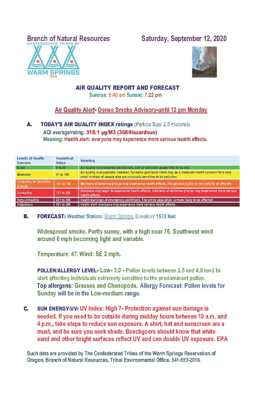
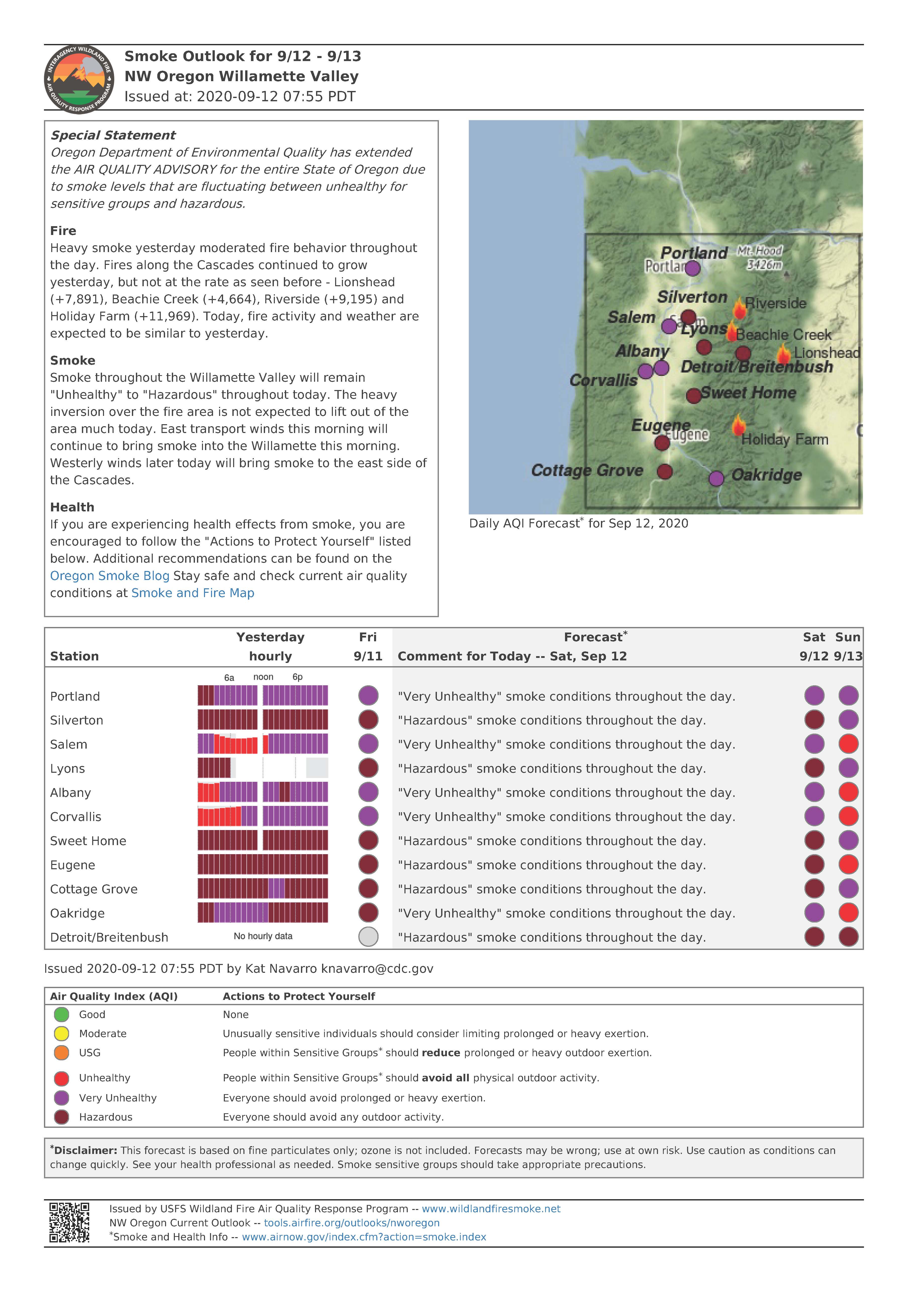
Air Quality Report and Forecast for Saturday September 12 2020
Related Incident:
Publication Type: News
Air quality and smoke summaries are below
Daily Update for Saturday September 12 2020
Related Incident:
Publication Type: News
Start Date: 8/16/2020
Cause: Lightning
Incident Commander: Noel Livingston, Pacific Northwest Team 3
Approximate Size: 138,634 acres
Containment: 5%
Total Personnel: 1472
Approximate Distance: 20 miles west of Warm Springs
Resources on the Fire:
53 crews
66 engines
10 dozers
49 water tenders
11 helicopters
Cooperating Agencies:
Marion County Sheriff
Linn County Sheriff
Jefferson County Sheriff
Deschutes County Sheriff
Virtual Community Meeting to be hosted on Lionshead Facebook Page today at 7:30 p.m. – We would like to encourage the public to email questions to 2020.lionshead@firenet.gov. You do not need to have a Facebook account to view the live meeting at www.facebook.com/lionsheadfire
Weather and Fire Behavior: Heavy smoke from The Lionshead, Beachie Creek and Riverside Fires filled Central and Eastern Oregon on Friday as westerly winds moved over the crest of the cascades. The heavy smoke kept temperatures in the low 70’s and relative humidity much higher than predicted in the mid-twenties. Forecasted upper level winds should break the smoke layer free Monday followed later in the week by cooler temperatures and a possibility of light precipitation. Fire growth was minimal yesterday, some areas experienced minimal torching and short-range spotting.
Current Situation: Reduced fire behavior has given firefighters valuable time to make progress on assessing the western side of The Lionshead Fire and anchoring in the fire on the eastern portion. Crews continued through the day yesterday and last night finishing key sections of the strategic firing operations. Firefighters and heavy equipment made substantial progress in preparing containment lines around the Ollalie Butte area yesterday. Several structure task forces continue to secure structures and infrastructure in and around Idanha and Detroit. Firefighters are also finding additional access into the Breitenbush area. Structure crews will begin working on damage assessments of properties where the fire activity and burned area hazards allow them to safely do so. The roadways into the burned areas continue to be very hazardous. Firefighters on the eastern side of the crest of the cascades on the Warm Springs Reservation were busy through the night mopping up and completing firing operations.
Today’s Activities: On both sides of the cascades, scouting and preparation of identified control lines will continue. Heavy smoke and blocked road access into many of the areas continue to be challenges. On the northern side of the fire, opening roads and improving access into the Breitenbush area will continue. To the north firefighters will wrap several structures in the fires path where the fire continues to be active. Containment lines around Ollallie lake and areas of the Warm Springs Reservation will continue to be prepared today in preparation for a strategic firing operation that will improve the fire line. Completing the northern section of containment line and tying it in with the eastern flank will create a catcher’s mitt, that is meant to stop the main body of the fire as it burns into the hardened containment lines. Scouting and contingency plans are also being put in to place northwest of Camp Sherman in the Mt. Jefferson Wilderness and old fire scars throughout the landscape.
Evacuations: Please monitor the local area sheriff’s department websites and Facebook for updates. The Oregon Office of Emergency Management has created an interactive database to help provide the most up to date information on evacuation statewide. https://www.oregon.gov/oem/emops/Pages/RAPTOR.aspx
Closures: For public and firefighter safety, roads and trails on the southwest portion of the Warm Springs Reservation near the fires are closed to the public. Forest closures are in place for Deschutes, Mt. Hood and Willamette National Forests. Deschutes NF Alerts Willamette NF Alerts Mt. Hood NF Alerts
FOR ADDITIONAL FIRE INFORMATION:
Inciweb: https://inciweb.nwcg.gov/incident/7049/
Facebook: www.facebook.com/LionsheadFire
Email: 2020.lionshead@firenet.gov
Fire Information: 971-277-5075
Virtual Community Meeting Notice
Related Incident:
Publication Type: Announcement
LIONSHEAD FIRE - Virtual Community Meeting
7:30 PM - Saturday, September 12
Join us live on Facebook at: https://www.facebook.com/LionsheadFire
We will provide an operational briefing about the Lionshead Fire followed by a question and answer session. Email your Lionshead Fire questions to: 2020.lionshead@firenet.gov
Open Burning Ban for Reservations in Oregon and Washington
Related Incident:
Publication Type: Announcement
Tim Outman, Air Quality Specialist
EPA Air Quality Advisory and Open Burning Ban for Reservations in Oregon and Washington
(Seattle – Friday, Sept. 11, 2020) The U.S. Environmental Protection Agency (EPA) Region 10 has issued a ban on open burning for all reservations in Oregon and Washington State, due to smoke from large wildfires. This ban takes effect immediately and will remain in effect until further notice.
The burn ban applies to all outdoor and agricultural burning—including camping and recreational fires—in all areas within external reservation boundaries regardless of ownership or tribal membership. Ceremonial and traditional fires are exempt from the burn ban. For areas outside reservation boundaries, please contact your local clean air agency, fire department, or department of ecology.
EPA requests that reservation residents reduce all sources of air pollution as much as possible, including driving and idling of vehicles.
Air pollution can harm your health and can have lasting effects. Community cooperation with the ban will help people who are most at risk, including children, the elderly, pregnant women, people with asthma or difficulty breathing, diabetes, heart problems or otherwise compromised health. These sensitive groups should avoid outdoor exercise and minimize exposure to outdoor pollution as much as possible. Under the most severe pollution levels all residents should restrict their activities.
The burn ban is effective immediately. This burn ban may be downgraded or removed depending on air quality and weather conditions. Please check our website for the latest information: https://www.epa.gov/farr/burn-bans-indian-reservations-id-or-and-wa
# # #
To check conditions in your area, go to http://www.airnow.gov/ .
For current burn ban status, please visit https://waburnbans.net/, the tribal air quality office at (509) 865-5121 Ext. 6078 or 1-509-945-6675, or the EPA at 1-800-424-4372, email to R10_farrhotline@epa.gov.
Please check our website for the latest information: https://www.epa.gov/farr
# # #
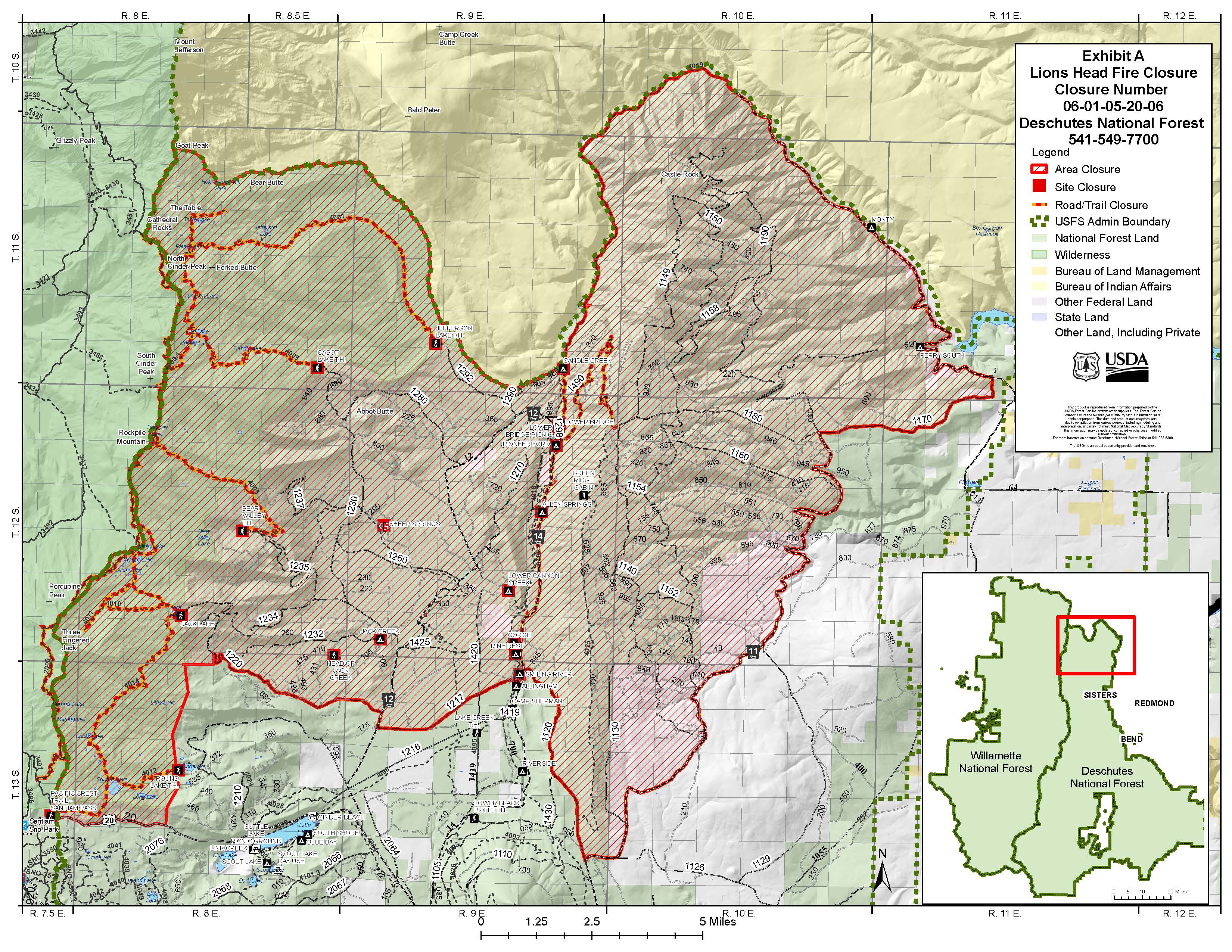
Fire Area Emergency Closure Deschutes NF Sisters Ranger District
Related Incident:
Publication Type: News
Fire Area Emergency Closure from the Deschutes National Forest Sisters Ranger District
Fire Closure Order #06-01-05-20-06 is below
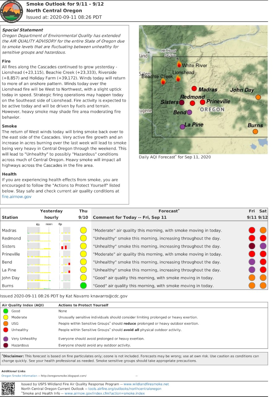
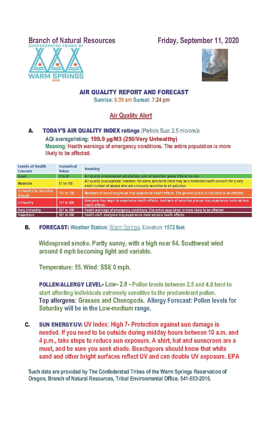
Air Quality and Smoke Summary for Friday September 11 2020
Related Incident:
Publication Type: News
Air quality and smoke summaries can be found below.
Complete smoke outlook and can be found here - https://fires.airfire.org/outlooks/columbia_river_gorge_or_wa