
Covid19 and Fire Season
Related Incident:
Publication Type: News
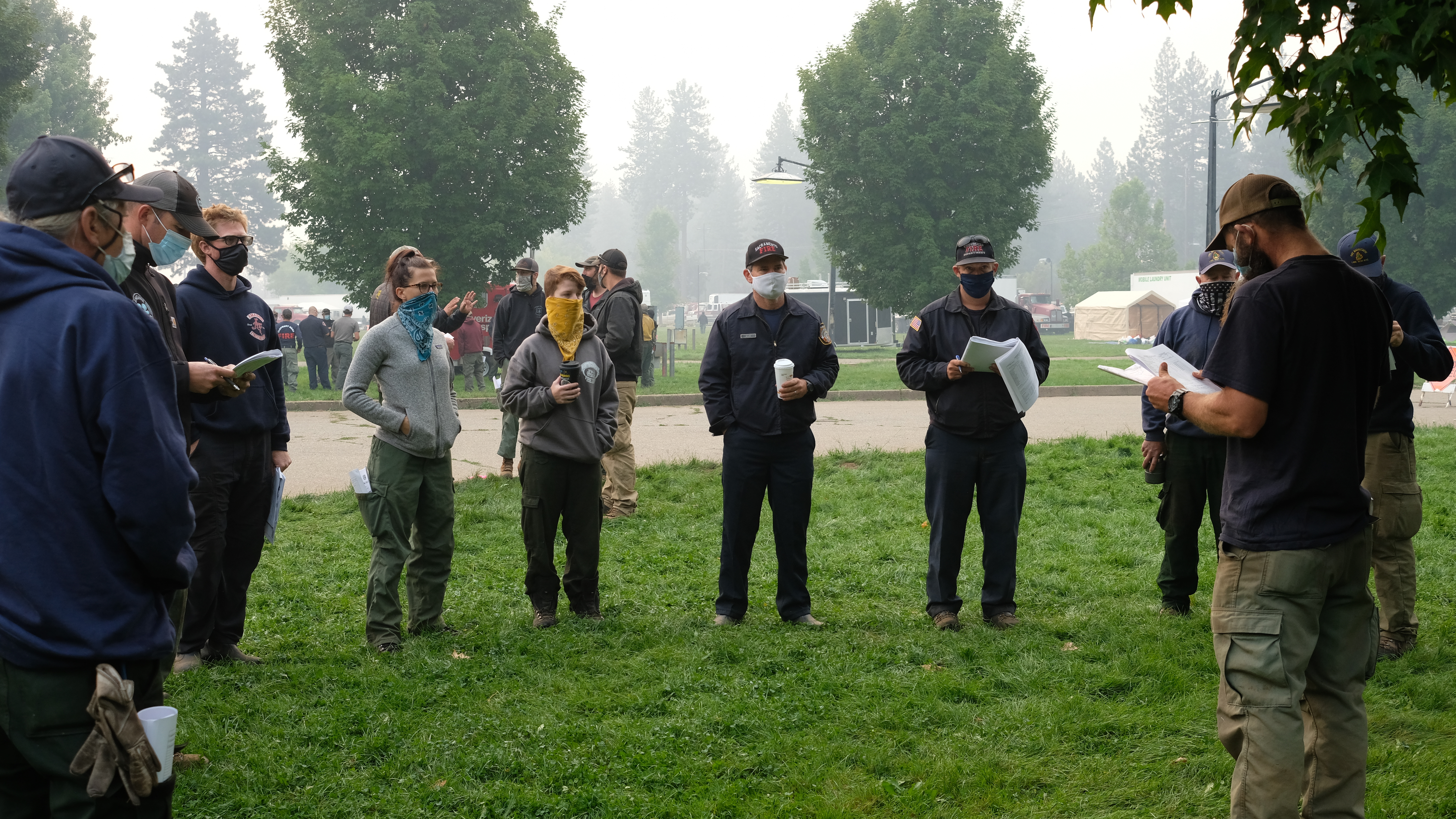
The overlap of the COVID-19 pandemic with wildfire season in the United States has complicated fire response drastically this summer. For one, people who are either susceptible to or affected by COVID-19 might have health conditions (both underlying and unknown) that also make them vulnerable to wildfire smoke exposure in the communities close to active wildfires. The influx of firefighters, contractors and other staff who respond to wildfires from outside the local area adds yet another potential layer of risk to communities already in the throes of dealing with a wildfire in their area. With these risks in mind, the incident management team assigned to the North Complex has implemented measures to reduce potential exposure to those working on the fires, as well as members of the communities impacted by the fires.
The biggest difference this season are in the fire camps themselves—congregation in fire camp is actively discouraged with to-go-style meals, while ample space has been provided for individual resources to stay appropriately distanced while in camp. The incident management team has also encouraged remote camps for crews and other resources, which often benefits them by keeping them closer to their work areas, cutting down on drive time.
More than just social distancing, hand washing and wearing masks, the team has sought avenues to keep firefighters and support personnel out of the community; these measures include choosing a camp location that provides an ample buffer between fire personnel and community members, utilizing proper procedures if and when contact is made with the public, and taking advantage of available technology to limit public interaction. An example of such technology would be our weekly virtual public meetings—being done over Zoom—as well as our interactive Story Maps that outline the progression of the fire and locations of fire information boards in impacted communities.
The North Complex Interactive Story Map can be found here: https://storymaps.arcgis.com/stories/c0dab2e4b7d54375a11f734ef1f3859e
Detailed locations of Fire Information Boards can be found here: https://storymaps.arcgis.com/stories/5a12c649b6f64cde90cd6ae21affe701
UPDATED EVACUATION INFORMATIONLassen County Sheriff 82820
Related Incident:
Publication Type: Announcement
UPDATED PRESS RELEASE 8/28/2020 9:30AM
SHEEP (NORTH COMPLEX) FIRE EVACUATION WARNING LIFTED FOR SOME AREAS
Effective Friday, August 28th at 10am, the following Evacuation Warnings are lifted:
• Highway 36 from Harris Drive west to Devil’s Corral and all road accessed by Highway 36.
• County Road A-1 to Lake Forest Estates and all roads accessed by A-1 to that point.
The following are instructions for residents returning home:
1. Residents should be aware that changing conditions in fire activity may cause this area to escalate back to a mandatory evacuation order at any time.
If you have evacuated large animals and vehicles, please keep them out of the area.
2. Please use caution, reduce your speed, drive with your headlights on and yield to emergency personnel.
3. Just because the flames are out doesn’t mean the danger is over. Damaged trees, structural damage, and flash flooding are just some of the dangers that exist after a wildfire. DO NOT put yourself or your loved ones in danger by exploring. Expect to see hotspots for some time. Do not call 911 to report unless there is an immediate threat to life or property.
The following Mandatory Evacuation Orders are in effect for the following areas:
• Baxter Creek Road.
• Wingfield Road at Baxter Creek Road to where the pavement begins at Peter Lassen’s Grave.
• Cheney Creek Road and all roads accessed by Cheney Creek Road.
The following Evacuation Warnings are in effect for the following areas:
• Gem Drive, Pearl Circle, and all roads accessed by those roads.
• Richmond Road and all roads accessed by Richmond Road from Hwy 395 to Pearl Circle. but NOT Cheney Creek Road, Baxter Creek Road, or the closed portion of Wingfield Road which are still under Mandatory Evacuation Order.
• Wingfield Road from Richmond Road to Peter Lassen’s Grave.
• Sunnyside Road from Hwy 395 to County Road A-3.
• Everything West of Highway 395 from Richmond Road East at the intersection by Susanville Ford to Janesville Grade and all roads in between.
• Main Street Janesville from Highway 395 to Janesville Grade and all roads accessed by Main Street Janesville.
• Bass Hill Road.
• Wingfield Road East from Bass Hill Road to Wingfield Road East including Elysian Valley Road, Indians Road and all connecting roads but NOT Baxter Creek Road.Road Closures:
• Cheney Creek Road.
• Wingfield Road at Baxter Creek Road to where the pavement begins at Peter Lassen’s Grave.
• Elysian Valley Road.
• Forest Service Road 29N03 by Roxie Peconom Campground.
For questions about whether your address is under mandatory, warning, or lifted status, please call (530)316-4487. Dispatch has been flooded with calls that can better be answered by someone who isn't also trying to answer emergency calls. People under order need to leave immediately. People under warning need to prepare to leave soon. Please use caution, drive with your headlights on and yield to emergency personnel. Residents needing assistance evacuating are asked to call the dispatch center at (530)257-6121. If you need shelter, go to the Lassen Community College Dormitories. Large animals can be housed at the Lassen County Fairgrounds. Go to the Fair office on Russell Drive first before 5pm. After 5pm, call the Emergency Shelter Line at (530)250-9088. Liability, feed, and care of large animals is the sole responsibility of the animal’s owner. Deputies will be going door to door to make notification.
Smoke Outlook 82820
Related Incident:
Publication Type: News
See related file for today's SMOKE OUTLOOK
Sheep Fire AM UPDATE
Related Incident:
Publication Type: News
Acres: 29,410 Contained: 30%
Resources: 24 dozers, 91 engines, 10 hand crews, 8 helicopters, 24 water tenders, 4 other heavy equipment, and 684 total personnel.
Community boards: Fire staff are posting information daily throughout the communities impacted by the North Complex fires. Find out where here: https://arcg.is/18vnSe
Current Situation: Crews continue to construct fireline, improve existing lines and mop up today, in addition to improving roads to contain the southern, western and northern sections of the Sheep Fire. Fire activity yesterday was mild as compared to previous days, despite isolated thunderstorms over the fire area. On the east flank, crews worked to strengthen the fireline established Wednesday. This line runs from Circle Drive around the northeast end of the fire. It extends to Diamond Mountain Motorway to the escarpment and to the top of Diamond Mountain. The steepest part of that line is challenging crews who must contend with falling snags and downhill rolling rocks as they mop up the fire. The west flank of the fire continues from Cheney Creek to Roxie Peconom Road, and then southwest toward the heel of the fire in the area of Indicator Peak. Crews will continue to strengthen and mop up firelines while continuing to provide structure protection, if needed.
Evacuations: Yesterday, the Mandatory Evacuation Orders for Dirt Wingfield Road to Baxter Creek Road but not including Baxter Creek Road, and Elysian Valley Road, Indians Road, and all connecting roads were downgraded to an Evacuation Warning. Mandatory Evacuation Orders remain in effect for Baxter Creek Road, Wingfield Road at Baxter Creek Road to where the pavement begins at Peter Lassen’s Grave, and Cheney Creek Road and all roads accessed by Cheney Creek Road. For the latest evacuation information, visit the Lassen County Sheriff’s Facebook page – facebook.com/LassenSheriff. For questions about whether your address is under mandatory, warning, or lifted status, please call North Complex Information at (530) 316-4487. Lassen Community College Dormitories remains an evacuation center for local residences. Large animals can be housed at the Lassen County Fairgrounds.
Road Closures: Cheney Creek Road; Wingfield Road at Baxter Creek Road to where the pavement begins at Peter Lassen’s Grave; Elysian Valley Road; Forest Service Road 29N03 by Roxie Peconom Campground. Plumas County Road 213 is closed at the intersection of the 28N03 Road north to the Plumas National Forest boundary where it turns into County Road 204. The 28N03 Road (the alternate route to Antelope Lake) remains open. Visit CalTrans at quickmap.dot.ca.gov or call 1-800-427-7623 for the latest maps and information of road closures in your area.
Weather: Potential thunderstorm development in the area today could produce outflow winds and erratic fire behavior. Fire behavior will be moderate early Friday, then will increase in the afternoon, which will likely lead to lifting smoke and haze in the fire area.
Air Quality: East winds are expected through the afternoon, which will continue to move smoke to the west and south. Smoke from the North Complex that settled over the area last night is forecasted to dissipate this afternoon but might return to the region again this evening. Impacts are again seen closest to the fire. Quincy and Susanville continue to be hardest hit by poor air quality.
COVID-19: California Interagency Incident Management Team 1 has implemented precautionary measures to prevent the spread of COVID-19 in both fire the surrounding communities.
Sheep Fire PM UPDATE 8272020
Related Incident:
Publication Type: News
AUGUST 27, 2020 8pm
Sheep Fire – Evening Update
Acres: 28,980 Contained: 16%
Resources: 24 dozers, 91 engines, 10 hand crews, 8 helicopters, 24 water tenders, 4 other heavy equipment, and 684 total personnel.
Community boards: Fire staff are posting information daily throughout the community. Find out where: https://arcg.is/18vnSe
Current Situation: Today, crews continued to strengthen and mop up existing firelines. Though there were some isolated thunderstorms, fire activity was mild as compared to previous days. On the east flank, crews worked to strengthen the fireline established on Wednesday. This line runs from Circle Drive around the northeast end of the fire. It extends to Diamond Mountain Motorway to the escarpment and to the top of Diamond Mountain. The steepest part of that line is challenging crews who must contend with falling snags and downhill rolling rocks as they mop up the fire. On the northwest flank, crews have constructed direct dozer line above Susan Hills all the way to Cheney Creek. The west flank of the fire continues from Cheney Creek to Roxie Peconom Road, and then southwest towards the heel of the fire in the area of Indicator Peak. A strategic firing operation was conducted this morning on this flank, and another will be conducted this evening to further secure this section of line. Tonight, in addition to the firing operation, crews will continue to strengthen and mop up firelines while continuing to provide structure protection, if needed.
Evacuations: This morning, the Mandatory Evacuation Orders for Dirt Wingfield Road to Baxter Creek Road but not including Baxter Creek Road, and Elysian Valley Road, Indians Road, and all connecting roads were downgraded to an Evacuation Warning. Mandatory Evacuation Orders remain in effect for Baxter Creek Road, Wingfield Road at Baxter Creek Road to where the pavement begins at Peter Lassen’s Grave, and Cheney Creek Road and all roads accessed by Cheney Creek Road. For the latest evacuation information, visit the Lassen County Sheriff’s Facebook page – facebook.com/LassenSheriff. For questions about whether your address is under mandatory, warning, or lifted status, please call North Complex Information at (530) 316-4487. Lassen Community College Dormitories remains an evacuation center for local residences. Large animals can be housed at the Lassen County Fairgrounds.
Road Closures: Cheney Creek Road; Wingfield Road at Baxter Creek Road to where the pavement begins at Peter Lassen’s Grave; Elysian Valley Road; Forest Service Road 29N03 by Roxie Peconom Campground. Plumas County Road 213 is closed at the intersection of the 28N03 Road north to the Plumas National Forest boundary where it turns into County Road 204. The 28N03 Road (the alternate route to Antelope Lake) remains open.
Visit CalTrans at quickmap.dot.ca.gov or call 1-800-427-7623 for the latest maps and information of road closures in your area.
Weather: Hotter and drier conditions and a windshift brought increased fire activity over much of the fire area. Tomorrow, there is a chance for scattered thunderstorms, increased winds, and erratic fire behavior.
Air Quality: Widespread haze continues to linger but improved mixing should help dissipate some of the smoke. Smoke is expected to spread around quite a bit. Quincy and Susanville can expect continued higher levels of smoke while other areas near the North Complex should see Moderate and Unhealthy for Sensitive Groups levels of smoke.
COVID-19: California Interagency Incident Management Team 1 has implemented precautionary measures to prevent the spread of COVID-19 in both fire the surrounding communities.
EVACUATION INFORMATION UPDATE Lassen County Sheriff 8272020 930 AM
Related Incident:
Publication Type: Announcement
UPDATED PRESS RELEASE 8/27/2020 9:30AM SHEEP (NORTH COMPLEX) FIRE EVACUATION ORDERS DOWNGRADED FOR SOME AREAS Effective Thursday, August 27th at 9:30am, the following Mandatory Evacuation Orders have been downgraded to an Evacuation Warning: • Dirt Wingfield Road to Baxter Creek Road but not including Baxter Creek Road. • Elysian Valley Road, Indians Road, and all connecting roads. The following are instructions for residents returning home: 1. Residents should be aware that changing conditions in fire activity may cause this area to escalate back to a mandatory evacuation order at any time. If you have evacuated large animals and vehicles, please keep them out of the area. 2. Please use caution, reduce your speed, drive with your headlights on and yield to emergency personnel.
3. Just because the flames are out doesn’t mean the danger is over. Damaged trees, structural damage, and flash flooding are just some of the dangers that exist after a wildfire. DO NOT put yourself or your loved ones in danger by exploring. Expect to see hotspots for some time. Do not call 911 to report unless there is an immediate threat to life or property. The following Mandatory Evacuation Orders are in effect for the following areas: • Baxter Creek Road. • Wingfield Road at Baxter Creek Road to where the pavement begins at Peter Lassen’s Grave. • Cheney Creek Road and all roads accessed by Cheney Creek Road. The following Evacuation Warnings are in effect for the following areas: • Gem Drive, Pearl Circle, and all roads accessed by those roads. • Richmond Road and all roads accessed by Richmond Road from Hwy 395 to Pearl Circle. but NOT Cheney Creek Road, Baxter Creek Road, or the closed portion of Wingfield Road which are still under Mandatory Evacuation Order. • Wingfield Road from Richmond Road to Peter Lassen’s Grave. • Sunnyside Road from Hwy 395 to County Road A-3. • Everything West of Highway 395 from Richmond Road East at the intersection by Susanville Ford to Janesville Grade and all roads in between. • Main Street Janesville from Highway 395 to Janesville Grade and all roads accessed by Main Street Janesville. • Bass Hill Road. • Wingfield Road East from Bass Hill Road to Wingfield Road East including Elysian Valley Road, Indians Road and all connecting roads but NOT Baxter Creek Road. Road Closures: • Cheney Creek Road. • Wingfield Road at Baxter Creek Road to where the pavement begins at Peter Lassen’s Grave. • Elysian Valley Road. • Forest Service Road 29N03 by Roxie Peconom Campground. For questions about whether your address is under mandatory, warning, or lifted status, please call (530)316-4487. Dispatch has been flooded with calls that can better be answered by someone who isn't also trying to answer emergency c
People under order need to leave immediately. People under warning need to prepare to leave soon. Please use caution, drive with your headlights on and yield to emergency personnel. Residents needing assistance evacuating are asked to call the dispatch center at (530)257-6121. If you need shelter, go to the Lassen Community College Dormitories. Large animals can be housed at the Lassen County Fairgrounds. Go to the Fair office on Russell Drive first before 5pm. After 5pm, call the Emergency Shelter Line at (530)250-9088. Liability, feed, and care of large animals is the sole responsibility of the animal’s owner. Deputies will be going door to door to make notification.
Sheep Fire AM UPDATE 8272020
Related Incident:
Publication Type: News
AUGUST 27, 2020 8am
Sheep Fire – Morning Update
Acres: 28,980 Contained: 16%
Resources: 20 dozers, 95 engines, 10 hand crews, 8 helicopters, 24 water tenders, and 668 total personnel.
Current Situation: Crews worked throughout the night building new fireline and strengthening and mopping up existing line. On the east flank, crews worked to strengthen the fireline established on Wednesday. This line runs from Circle Drive around the northeast end of the fire. It extends from Diamond Mountain Motorway to the escarpment and to the top of Diamond Mountain. The steepest part of that line is challenging crews who must contend with falling snags and downhill rolling rocks. On the northwest flank, crews have constructed direct dozer line above Susan Hills all the way to Cheney Creek. The west flank of the fire continues from Cheney Creek to Roxie Peconom Road. Last night, crews were able to complete dozer line south and southwest on that flank, towards the heel of the fire in the area of Indicator Peak. Today, crews will continue to strengthen and mop up all fire lines while continuing to provide structure protection.
Evacuations: A Mandatory Evacuation Order was issued for the North Side of Diane Drive yesterday afternoon but downgraded back to an Evacuation Warning by early evening as firefighters were able to knock down the spots affecting that area. Other orders include everything west of Elysian Valley Road and Wingfield Road including all connecting roads; Wingfield Road west to Bass Hill Road and all connecting roads in between; Cheney Creek Road and all roads accessed by Cheney Creek Road. Several evacuation warnings remain in effect. For the latest evacuation information, visit the Lassen County Sheriff’s Facebook page – facebook.com/LassenSheriff. For questions about whether your address is under mandatory, warning, or lifted status, please call North Complex Information at (530) 316-4487. Lassen Community College Dormitories remains an evacuation center for local residences. Large animals can be housed at the Lassen County Fairgrounds.
Road Closures: Cheney Creek Road; Wingfield Road from the end of the pavement by Peter Lassen’s Grave to Bass Hill Road; Elysian Valley Road; Forest Service Road 29N03 by Roxie Peconom Campground. Plumas County Road 213 is closed at the intersection of the 28N03 Road north to the Plumas National Forest boundary where it turns into County Road 204. The 28N03 Road (the alternate route to Antelope Lake) remains open.
Visit CalTrans at quickmap.dot.ca.gov or call 1-800-427-7623 for the latest maps and information of road closures in your area.
Weather: Today brings a change in the weather pattern as hotter, drier conditions move in. With lower humidity and increased heat comes the potential for increased fire activity and the likelihood residents and visitors will see larger smoke columns than in recent days. While humidities will dip into the 15-25% range, winds will remain relatively calm and westerly in the morning, shifting to northwest later in the day.
Air Quality: Widespread haze continues to linger but improved mixing should help dissipate some of the smoke. Terrain driven winds are expected to turn westerly in the afternoon and W/NW in the evening. Smoke is expected to spread around quite a bit. Quincy and Susanville can expect continued higher levels of smoke while other areas near the North Complex should see Moderate and Unhealthy for Sensitive Groups levels of smoke.
COVID-19: California Interagency Incident Management Team 1 has implemented precautionary measures to prevent the spread of COVID-19 in fire camp and surrounding communities. These measures include daily temperature screenings, mandatory use of face coverings, social distancing, implementing more virtual work, and smaller fire camps. Community and firefighter safety are a top priority of both Team 1 and the National Forests.
Sheep Fire PM UPDATE 8262020
Related Incident:
Publication Type: News
AUGUST 26, 2020 8pm
Sheep Fire – Evening Update
Acres: 28,980 Contained: 16% Resources: 20 dozers, 95 engines, 10 handcrews, 8 helicopters, 24 water tenders, and 668 total personnel.
Current Situation: Crews worked throughout the day strengthening fire lines on the east and west flanks of the fire. On the east flank (Division H), crews worked to strengthen the fireline established yesterday. This line runs from Circle Drive around the northeast end of the fire. It extends from Diamond Mountain Motorway to the escarpment and to the top of Diamond Mountain. On the northwest flank (Divisions F), crews constructed direct dozer line above Susan Hills all the way to Cheney Creek. On the west flank (Division D) they continued from Cheney Creek to Roxie Peconom Road. Crews worked towards the heel of the fire on south and southwest flank, in the area of Indicator Peak. At 4:30 p.m., a flare up occurred in the Bass Hill - Diane Drive area. Air tankers, helicopters, and ground resources were diverted to that area and additional evacuations were ordered. Dry fuels, steep terrain, falling snags and downhill rolling rocks are challenging firefighting efforts. Tonight, crews will continue to secure and strengthen both flanks of the fire while providing structure protection.
Evacuations: A Mandatory Evacuation Order was issued for North Side of Diane Drive at 4:45 pm this afternoon but was downgraded back to an Evacuation Warning by 6:30 pm. Other orders include everything west of Elysian Valley Road and Wingfield Road including all connecting roads; Wingfield Road west to Bass Hill Road and all connecting roads in between; Cheney Creek Road and all roads accessed by Cheney Creek Road. Several evacuation warnings remain in effect. For the latest evacuation information, visit the Lassen County Sheriff’s Facebook page – facebook.com/LassenSheriff. For questions about whether your address is under mandatory, warning, or lifted status, please call North Complex Information at (530) 316-4487. Lassen Community College Dormitories remains an evacuation center for local residences. Large animals can be housed at the Lassen County Fairgrounds.
Road Closures: Cheney Creek Road; Wingfield Road from the end of the pavement by Peter Lassen’s Grave to Bass Hill Road; Elysian Valley Road; Forest Service Road 29N03 by Roxie Peconom Campground. Visit CalTrans at quickmap.dot.ca.gov or call 1-800-427-7623 for the latest maps and information of road closures in your area.
Weather: Overnight, winds will be generally west-southwest at 5-10mph in the lower elevations and southwest at 5-10 gusting to 15 on the upper slopes. Hotter, drier weather is forecast starting Thursday and continuing through the weekend with temperatures increasing by roughly 10 degrees throughout the area. Southeast air flow Friday will bring a slight chance of slow moving thunderstorms. Otherwise, hot and dry will be the theme this weekend into early next week.
Air Quality: Quincy and Susanville continue to be impacted by Unhealthy to Hazardous levels of smoke. Southwest winds should keep smoke moving to the northeast of the fires. For more information on air quality and to see monitors near you, visit Airnow or the California Smoke Blog. For more information on what you can do to protect yourself and loved ones, visit the EPA's site on fires and your health. Your local health department is also a good source of information.
COVID-19: California Interagency Incident Management Team 1 has implemented precautionary measures to prevent the spread of COVID-19 in fire camp and surrounding communities. These measures include daily temperature screenings, mandatory use of face coverings, social distancing, implementing more virtual work, and smaller fire camps. Community and firefighter safety are a top priority of both Team 1 and the National Forests.
EVACUATION INFORMATION UPDATE Lassen County Sheriff 82620 630 PM
Related Incident:
Publication Type: Announcement
8/26/2020 6:30PM #SheepFire Diane Drive Evacuation Update The Mandatory Evacuation Order for the North side of Diane Drive has been downgraded back to an Evacuation Warning. The following are instructions for residents returning home: 1. Residents should be aware that changing conditions in fire activity may cause this area to escalate back to a mandatory evacuation order at any time. If you have evacuated large animals and vehicles, please keep them out of the area. 2. Please use caution, reduce your speed, drive with your headlights on and yield to emergency personnel. 3. Just because the flames are out doesn’t mean the danger is over. Damaged trees, structural damage, and flash flooding are just some of the dangers that exist after a wildfire. DO NOT put yourself or your loved ones in danger by exploring. Expect to see hotspots for some time. Do not call 911 to report unless there is an immediate threat to life or property.