
Archie Creek Fire Evening Update Monday Sept 14 2020
Related Incident:
Publication Type: News
Archie Creek Fire Evening Update: Sunday, Sept. 14, 2020
Crews continue to report minimal to no fire activity along the western edge of the Archie Creek Fire from Glide up to the Nonpareil area. In the Little River Road area, crews are utilizing a combination of existing road systems and dozer lines to stop the fire from advancing downhill toward nearby structures. Spot fires across containment lines challenged firefighters in the Little River area today.
Fire activity picked up slightly on the southeastern portion of the fire due to northwest winds over the area. Firefighters plan to hold the fire in this area near Panther Creek. Crews also spent time today scouting the Canton Creek and Scaredman Creek areas, looking for opportunities to successfully engage on the fire. Heavy equipment will be used in this area to open existing roadways and construct new dozer lines to tie back into the Upper Rock Creek area.
Crews from the Oregon Department of Transportation and Pacific Power continue to work along Highway 138E within the burned area. The highway remains closed to all non-fire traffic between Milepost 21 and Milepost 83. Douglas County Public Works Department is also working to clear Rock Creek Road and other county maintained roads within the footprint of the Archie Creek Fire.
The Archie Creek Fire has burned 121,379 acres and is 15% contained. 708 people are now assigned to the Archie Creek Fire.
Archie Creek Fire update Monday Sept 14 2020
Related Incident:
Publication Type: News
Archie Creek Fire
Northwest Incident Management Team 9 (Incident Commander Brian Goff)
Email: 2020.archiecreek@firenet.gov
Phone: 971-334-7674
Hours: 7am-8pm
Crews continue working in the area to reinforce primary and secondary containment lines. In the Little River area, crews are using a combination of existing road systems and new dozer lines to check the fire’s spread. Structure protection resources remain in place area. Air operations were grounded for another day due to smokey conditions in the region.
Yesterday, 255 residents of certain areas of the Glide and Idleyld Park communities which were impacted by the Archie Creek Fire, attended a meeting to learn about the status of their home. In total, 109 residences have been identified as lost as a result of the fire. The specific locations of the losses are not being released at this time. Thus far, there have been no reports of fatalities or missing persons made to the Sheriff's Office. Our heartfelt sympathies go out to all those who have been displaced and negatively impacted by this fire. Donations to fire victims may be dropped off at the Glide Baptist Church or the through the Red Cross.
Evacuations, shelter areas: Douglas County Sheriff website www.dcso.com/evacuations and Facebook page at https://www.facebook.com/DouglasCoSO/
Air quality: The Oregon Department of Environmental Quality at http://www.oregon.gov/deq
Umpqua National Forest closures: Maps and closure orders can be found on Inciweb at: https://inciweb.nwcg.gov/incident/closures/7176/ . Additional information on the Forest Service closures are available at: https://www.fs.usda.gov/alerts/umpqua/alerts-noticesmanaged landseast of Interstate 5, within the Swiftwater Resource Area are closed.
Archie Creek Fire Evening Update Sunday Sept 13 2020
Related Incident:
Publication Type: News
Archie Creek Fire Evening Update: Sunday, Sept. 13, 2020
Favorable weather conditions resulted in another day of decreased fire activity on the Archie Creek Fire. Containment lines along the western flank of the fire were held in check from the South Fork of Calapooya Creek, down to Glide. Crews continue working in the area to reinforce primary and secondary containment lines. In the Little River area, crews are utilizing a combination of existing road systems and new dozer lines to check the fires spread. Structure protection resources remain in place throughout the Little River area. Air operations were grounded for another day due to smoky conditions in the region. The Archie Creek Fire has burned 121,379 acres and remains 10% contained.
Crews from the Oregon Department of Transportation and Pacific Power continue work along Highway 138E by cutting hazard trees, checking downed power lines and removing debris from the roadway. The highway remains closed to all non-fire personnel from mile marker 21 through to the Highway 97 junction. Road clearing operations also continued on Rock Creek Road.
Safety for our firefighters and the public remains our number one priority. Road and area closures in and around the Archie Creek Fire remain in place while firefighters continue suppression efforts.
Residents in some areas can find out about their property Sept 13 37 pm
Related Incident:
Publication Type: Announcement
From the Douglas County Sheriff: The Sheriff’s Office will hold a private informational drop-in meeting today, Sunday, Sept. 13, from 3 to 7 pm at the Glide High School.
This meeting is for residents of areas listed below who want to learn more about residential structural damage to their property and resources available to them.
The meeting will be open ONLY to residents of: Moore Hill Lane, Susan Creek Road, Star Mountain Lane, Smith Springs Lane, Evergreen Springs Lane, Hone Creek Road, Tioga Lane, Rock Creek Road (all side roads), North Umpqua Hwy from Rock Creek Road to Steamboat, Klahanie Lane, Skyview Drive, Lone Rock Road, South Lone Rock Road, Bar L Ranch Road (all side roads), Terrace Drive, Upper Terrace Lane, Mystic Mountain Lane, Evergreen Lane.
Archie Creek Fire update Sunday Sept 13 2020
Related Incident:
Publication Type: News
Northwest Incident Management Team 9 (Incident Commander Brian Goff)
Email: 2020.archiecreek@firenet.gov
Phone: 971-334-7674
Hours: 7am-8pm
Fire information: The Archie Creek Fire burning east of Roseburg is 121,379 acres. Containment is now 10%. The fire is burning in the North Umpqua drainage on the west slope of the Cascades. There are 539 personnel assigned to the fire. Additional resources are expected to arrive today. More are on order.
Current Situation: Fire fighter and public safety is the number one priority. Access to fire areas is limited due to smoke and blocked roads. Large tracts of private and federal timber lands continue to be threatened. Electrical transmission lines are damaged or are threatened. Recreation areas and resorts are closed due to the fire. There are evacuation orders in effect. Residents in several areas will be able to find out about their property at a public meeting today (see below).
Yesterday, firefighters assigned to the fire worked with local fire departments, industrial landowners and loggers on structure protection and creating containment lines around the fire perimeter. Most of the work was on the western flank of the fire between the Little River and the Nonpareil areas.
Air operations were grounded due to thick smoke. Crews from the Oregon Department of Transportation (ODOT) and fire crews are working to get Hwy 138E safe for fire traffic only at this time. The highway is closed to all non-fire traffic between Milepost 17 and the junction with Hwy 97.
Weather/fire behavior: Warm and dry conditions, along with breezy winds, will persist today. Smoke over Roseburg is likely to begin lifting today which may lead to increased fire activity. Overnight humidity will increase, but daytime humidity will remain quite low at higher elevations. Large and medium size fuels remain very dry, but overnight humidity has helped fine fuels.
From the Douglas County Sheriff: The Sheriff’s Office will hold a private informational drop-in meeting today, from 3 to 7 pm at the Glide High School. This meeting is for residents of areas listed below who want to learn more about residential structural damage to their property and resources available to them. The meeting will be open ONLY to residents of: Moore Hill Lane, Susan Creek Road, Star Mountain Lane, Smith Springs Lane, Evergreen Springs Lane, Hone Creek Road, Tioga Lane, Rock Creek Road (all side roads), North Umpqua Hwy from Rock Creek Road to Steamboat, Klahanie Lane, Skyview Drive, Lone Rock Road, South Lone Rock Road, Bar L Ranch Road (all side roads), Terrace Drive, Upper Terrace Lane, Mystic Mountain Lane, Evergreen Lane.
For further information:
Air quality: The Oregon Department of Environmental Quality at http://www.oregon.gov/deq
Umpqua National Forest closures: Maps and closure orders can be found on Inciweb at: https://inciweb.nwcg.gov/incident/closures/7176/ . Additional information on the Forest Service closures are available at: https://www.fs.usda.gov/alerts/umpqua/alerts-notices managed lands east of Interstate 5, within the Swiftwater Resource Area are closed.
Archie Creek Fire Evening Update Saturday September 12 2020
Related Incident:
Publication Type: News
Archie Creek Fire: Evening Update: Saturday, September 12, 2020
Today, wildland firefighters assigned to the Archie Creek fire worked with local fire departments, industrial
landowners and loggers on structure protection and creating containment lines around the perimeter of the
blaze. The majority of work today was completed along the western flank of the fire between the Little River
area and the Nonpareil area. Air operations were grounded for another day due to thick smoke which blanketed
the region. The fire has burned 115,857 acres and is 10 % contained. 495 people are now assigned to the Archie
Creek Fire.
Crews from the Oregon Department of Transportation made good progress on clearing Highway 138E through
the burned area. Fallers were used to remove hazard trees along the highway while heavy equipment removed
down trees and rocks from the roadway. Highway 138E remains closed between Milepost 17 and 83 for all
non-fire traffic. Road clearing operations were also completed by fire crews along Rock Creek Road.
Safety for our firefighters and the public remains our number one priority. Road and area closures in and around
the Archie Creek Fire remain in place while firefighters continue suppression efforts.
Sheriff’s Office News Release: A private informational drop-in meeting will be held Sunday, September 13 from 3
to 7 p.m. at the Glide High School. This meeting is for the residents of specific listed locations who want to learn
more about residential structural damage to their property and resources available to them. The Sheriff’s Office
has compiled a list of residences which have been damaged. The meeting is open to residents of the following
locations:
Moore Hill Lane
Susan Creek Road
Star Mountain Lane
Smith Springs Lane
Evergreen Springs Lane
Honey Creek Road
Tioga Lane
Rock Creek Road (all side roads)
North Umpqua Hwy from Rock Creek Road to Steamboat Klahanie Lane
Skyview Drive
Lone Rock Road
South Lone Rock Road
Bar L Ranch Rd (all side roads)
Terrace Drive
Upper Terrace Lane
Mystic Mountain Lane
Evergreen Lane
This meeting is not open to the public nor is it open to members of the media. Attendees will be asked to show
identification/proof of residency and are asked to adhere to COVID-19 recommendations.
Archie Creek Fire update Saturday September 12 2020
Related Incident:
Publication Type: News
Archie Creek Fire Update, September 12, 2020
Fire Update:
Fire information: The Archie Creek Fire burning east of Roseburg is now 115,857 acres and is at 0% containment. It is burning in the North Umpqua drainage on the west slope of the Cascades. There are 369 people assigned to the fire.
Current Situation: Fire fighter and public safety is the number one priority. Access to fire areas are limited due to smoke inversion and blocked roads. Large tracts of private and federal timber lands continue to be threatened. Electrical transmission lines are damaged or are threatened. Recreation areas and resorts are closed due to the fire.
Progress is being made with structure assessments, protection of structures, use of roads, power infrastructure, containment of fire, and opportunities for future containment. Additional resources are coming to help. It takes time with resources spread thin and changing weather to have confidence to claim containment.
Yesterday, firefighters worked on the fire with local fire departments, industrial landowners and loggers to construct fire lines and provide structure protection. Oregon Department of Transportation (DOT) and fire crews worked to clear fallen trees and large rocks from Hwy 138 East and Rock Creek Road.
Indirect fire line construction will continue today. Direct dozer line construction will continue on the western and southern flanks of the fire where practical and where topography will allow.
Northwest IMT 9 (I.C. Goff) is managing the fire in coordination with the Umpqua National Forest, the Roseburg Bureau of Land Management (BLM), the Douglas Forest Protective Association (DFPA), the Douglas County Sheriff’s Office, Search and Rescue, local fire departments and local logging companies.
Weather: Warm and dry conditions, along with breezy afternoon winds, will persist through the weekend. Smoke may limit daytime highs. Humidity should improve over the next few days, especially overnight recoveries, but daytime humidity will remain quite low at higher elevations.
Current Evacuations:
LEVEL 1 "BE READY" – All Douglas County residents should be ready to leave at all times.
LEVEL 2 "BE SET” –
Nonpareil Road from Plat K Road west to Gassy Creek
The community of Glide from the Green Bridge east to Little River Road. (Except for Lone Rock Road, Bar L Ranch Road, Upper Terrace, Terrace, Little River Road)
LEVEL 3 "GO!”
Dry Creek (Happy Creek Ln, Felix Flat, Elk Ridge, Illahee)
Steamboat Creek to the Green Bridge in Glide (Includes all addresses between these points, Includes the community of Idleyld Park)Lone Rock Road
Bar L Ranch Road
Upper Terrace Drive
Terrace Drive
Little River Road
Gassy Creek Road east to the end of Nonpariel Road
Shelter: Douglas County has an evacuation location for displaced wildfire residents, pets and livestock at the Fairgrounds. For information about space availability, contact the Fairground Office at 541-440-4394. For information on shelter for horses and large animals, contact the Douglas County Parks Department at 541-440-6040. For small animals (cats, dogs, birds, etc.), contact Saving Grace at 541-672-3907. For other small animals like pigs, sheep or goats, contact the Douglas County Fairgrounds.
The American Red Cross, working in conjunction with the Salvation Army, has set up an Emergency Shelter in Douglas Hall at the Douglas County Fairgrounds. For more information, please contact the Salvation Army at (541) 672-6581 and the American Red Cross at (541) 344-5244.
Safety of evacuated areas: Douglas County deputies and troopers from the Oregon State Police are patrolling residential areas in an effort to deter and detect criminal activities during the evacuation period. Residents who have video surveillance or cameras, should call and report any suspicious activity they observe.
The Sheriff's Office has created a page on its website which contains maps of the current evacuation zones. The maps attempt to provide a visual of the most current evacuation zones by showing roads and specific addresses in some cases. The maps can be found at www.dcso.com/evacuations and are updated as quickly as possible.
Air quality: The Oregon Department of Environmental Quality has issued an Air Pollution Advisory for today. For more information, visit http://www.oregon.gov/deq
Closures: Highway 138 East remains closed to non-fire traffic between Milepost 17 and 47. Motorists are advised to use alternative routes and to monitor www.tripcheck.com for updates on the highway closure.
Bureau of Land Management (BLM) – lands east of Interstate 5, within the Swiftwater Resource Area are closed.
Umpqua National Forest – the entire Umpqua National Forest is closed until the extreme fire danger is over, except for emergency personnel and persons that have a permit specifically authorizing their presence in the closure areas. These closures are to protect the public from the hazardous conditions on the ground and to decrease the chance of additional human caused fires. Also, chainsaw use on the Forest is prohibited.
Forest Service roads affected by the fire are being cleared by agency and fire personnel. State, county and other local jurisdiction roads remain under the direction of the specific agency.
Maps and closure orders can be found on Inciweb at: https://inciweb.nwcg.gov/incident/closures/7176/ . Additional information on the Forest Service closures are available at: https://www.fs.usda.gov/alerts/umpqua/alerts-notices
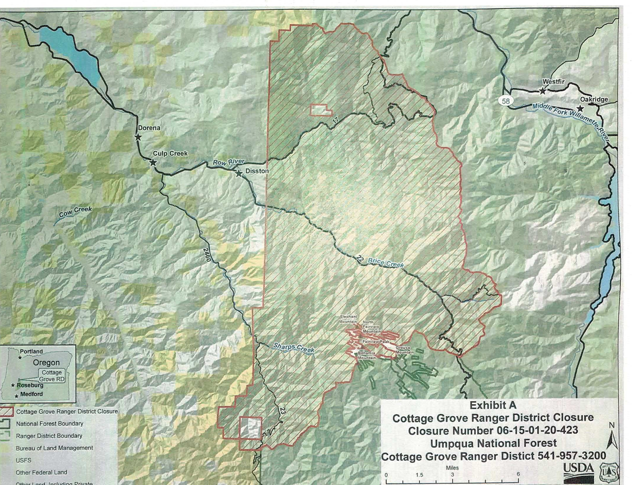
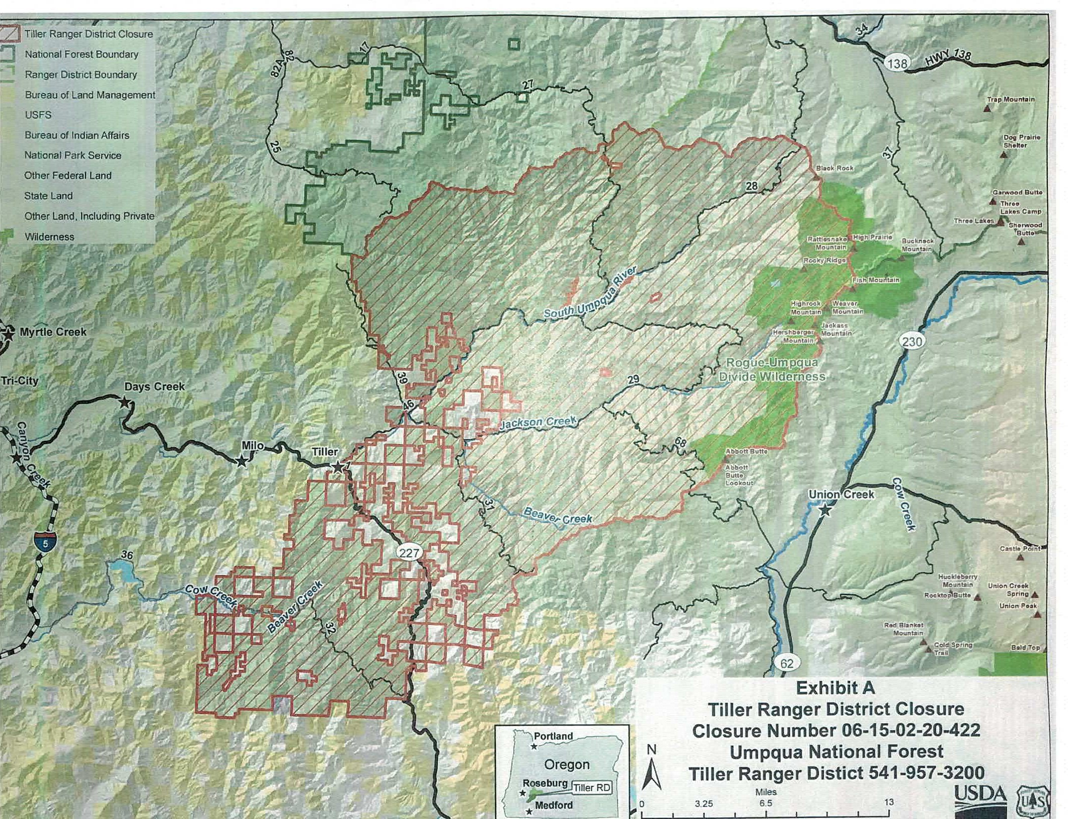
Umpqua National Forest Closed Due to Extreme Fire Danger
Related Incident:
Publication Type: Closures
Umpqua National Forest Closed Due to Extreme Fire Danger until Conditions Improve
ROSEBURG, OR – September 11, 2020 – Due to unprecedented fire activity the Umpqua National Forest has issued temporary closure orders for the Cottage Grove and Tiller Ranger Districts in addition to the earlier closures of the North Umpqua and Diamond Lake Districts. This now closes the entire Umpqua National Forest until the extreme fire danger is over. These orders restrict access to all but emergency personnel and persons that have a permit specifically authorizing their presence in the closure areas.
These closures are to protect the public from the hazardous conditions on the ground and decrease the chance of additional human caused fires. “Several roads in the Cottage Grove District are still blocked by numerous large trees that have come down in the wind events this week. We have some beautiful waterfalls and great campgrounds but we are asking the public to give us a chance to clean things up and let the fire danger subside” said Jed Hancock, Recreation Specialist on the Cottage Grove Ranger District. Gabe Wishart, Tiller District Ranger, also noted that many roads on the Tiller District have become blocked by falling trees from the wind events this week making travel difficult. We remind the public that chainsaw use on the Forest is prohibited under the Industrial Fire Precautions Level 4 restrictions in place. Chainsaws used to clear roads create a significant risk for new fire starts at this time. Forest Service roads affected by the fire are being cleared by agency and fire personnel.
Roads not under Forest Service jurisdiction such as State, County and other local jurisdictions remain under the direction of the specific agency. Please call them for more information.
Maps and closure orders (Orders 06-15-02-20-420 North Umpqua, 06-15-01-20-421 Diamond Lake, 06-15-02-20-422 Tiller and 06-15-01-20-423 Cottage Grove) can be found at https://www.fs.usda.gov/alerts/umpqua/alerts-notices .
We will reduce in size or cancel these orders as soon as it is advisable based on the weather, fire danger and emergency operations.
For more information about the Umpqua National Forest call the Forest at (541) 957-3200 or www.fs.usda.gov/umpqua.
Roseburg District Swiftwater Resource Area Closure
Related Incident:
Publication Type: Closures
EMERGENCY CLOSURE ORDER
Bureau of Land Management
Roseburg District, Swiftwater Resource Area
Action: Pursuant to 43 CFR 9268.3 and 43 CFR 8364.1, the Bureau of Land Management (BLM) hereby provides notice
that effective immediately, the public lands described below are closed to all forms of public access and will remain
closed until the Archie Creek Fire is declared controlled. This closure is necessary to protect public land users from risks
associated with active wildland fire, fire suppression, suppression repair, emergency stabilization, and burned area
rehabilitation. The closure is also needed to protect wildland fire fighters from recreational activities that could interfere
with fire suppression activities. The health and safety of and staff is our number one priority.
Affected Area: All BLM lands east of Interstate 5 managed by the Swiftwater Resource Area. The lands are in Douglas
and Lane Counties, Oregon.
Prohibitions: The public must not enter the closure area. All uses within the closure area are prohibited. Exceptions to
these prohibitions are noted below under Supplemental Information.
Dates: This closure is effective immediately and will remain in effect until such time as conditions allow for safe use of
the public lands.
Supplemental Information: The following persons are exempt from the provisions of this Order:
1. Any Federal, State, or Local Officer, or member of an organized medical, rescue or firefighting force engaged in
fire, emergency, or law enforcement activities, or public utility employees engaged in emergency repairs.
2. BLM employees, contractors, or agents engaged in official duties.
3. Individuals operating within the scope of their official and legitimate governmental duties.
4. Individuals with valid existing rights for access (e.g. Reciprocal and Unilateral Right of Way agreement holders or
internal landowners).
5. Parties who carry written approval signed by the BLM Authorized Officer allowing access to the described public
lands.
Penalties: Any person who fails to comply with a closure or restriction order issued under this subpart may be subject to
a fine not to exceed $1,000 and/or imprisonment not to exceed 12 months.
Effective: This Order is effective immediately upon signature.
Signed By:
__________//Heather Whitman 9/9/2020_____________________________ ___________
Heather Whitman Date
District Manager
Archie Creek Fire update Friday Sept 11 2020
Related Incident:
Publication Type: News
Public briefing: Archie Creek Fire Officials will hold a virtual public briefing today, Friday, Sept. 11, 2020 at 2:00 pm. This will be a live stream video information briefing regarding the fire affecting several communities in Douglas County. Please check the Archie Creek Fire Information Facebook page for a link to the live video beginning at 1:55 pm. The briefing will begin at 2:00 pm.
Current Situation: The Archie Creek Fire burning east of Roseburg is now 115,857 acres with 0% contained. It is burning in the North Umpqua drainage on the west slope of the Cascades. Today fire managers will continue assessment of the fire. They are working with local fire departments on structural protection and fire line construction as weather conditions allow. Line construction continues on west and southwest flanks, utilizing heavy equipment in cooperation with local timber companies. ODOT is working to clear Highway 138 E for fire traffic only. Pacific power is working to restore and protect lines and infrastructure. Structural fire departments are working directly with residents and on damage assessments.
Fire fighter and public safety is a concern and access to fire areas is limited at this time due to smoke inversion and blocked roads. Residences and commercial properties continue to be evacuated. Large tracts of private and federal timber lands continue to be threatened. Electrical transmission lines are damaged or are threatened.
Forest recreation areas are impacted. Recreational resorts are closed due to the fire.
Northwest Team 9 (I.C. Goff) is working with the Umpqua National Forest, the Roseburg Bureau of Land Management (BLM), Douglas Forest Protective Association (DFPA), Douglas County Sheriff’s Office, Search and Rescue, local fire departments and local loggers.
Weather: Extreme fire weather conditions will continue to hamper suppression. Low humidity, high temperatures and high winds continue to create extreme fire conditions. Smoke inversion limits use of aerialresources. Humidity is expected to increase over the weekend, with possible rain early next week.
Current Evacuations:
LEVEL 1 "BE READY": ALL DOUGLAS COUNTY RESIDENTS SHOULD BE IN THIS LEVEL OF READINESS AT ALL TIMES.
LEVEL 2 "BE SET:” Nonpareil Road 4400-7500 block (Including Fair Oaks Road, Fraser Canyon, Bonanza Mine, Plat K)
LEVEL 3 "GO!": LEAVE IMMEDIATELY!
Dry Creek (Happy Creek Ln, Felix Flat, Elk Ridge, Illahee)
Steamboat Creek to Little River Road in Glide (Includes all addresses between these points, Includes the towns of Idleyld Park and Glide)
All of Little River Road
The end of Nonpareil Road west to Banks Creek Road
Shelter: Douglas County has an evacuation location for displaced wildfire residents, pets and livestock. Information about space availability at the Fairgrounds, contact the Fairground Office at 541-440-4394. For information on shelter for horses and large animals, contact the Douglas County Parks Department at 541-440-6040. For small animals (cats, dogs, birds, etc.), contact Saving Grace at 541-672-3907. For other small animals like pigs, sheep or goats, contact the Douglas County Fairgrounds for space information.
The American Red Cross, working in conjunction with the Salvation Army, has set up a temporary Emergency Shelter in Douglas Hall at the Douglas County Fairgrounds. For more information, please contact the American Red Cross and the Salvation Army directly. You can reach the Salvation Army at (541) 672-6581 and the American Red Cross at (541) 344-5244.
Safety of evacuated areas: Douglas County deputies and troopers from the Oregon State Police are patrolling residential areas in an effort to deter and detect criminal activities during the evacuation period. Residents who have video surveillance or cameras, should call and report any suspicious activity they observe.
The Sheriff's Office has created a page on its website which contains maps of the current evacuation zones. The maps attempt to provide a visual of the most current evacuation zones by showing roads and specific addresses in some cases. The maps can be found at www.dcso.com/evacuations and are updated as quickly as possible.
Air quality: The Oregon Department of Environmental Quality has issued an Air Pollution Advisory for today. For more information, visit http://www.oregon.gov/deq
Closures: Highway 138 East remains closed to non-fire traffic between Milepost 17 and Highway 97 junction.Motorists are advised to use alternative routes and to monitor www.tripcheck.com for updates on the highway closure.
All Bureau of Land Management (BLM) managed lands, east of Interstate 5, within the Swiftwater Resource Area are closed.
Umpqua National Forest lands in the fire area are also closed. See the forest Facebook pge for updates.