
Archie Creek and Thielsen Fire Update for October 5 2020
Related Incident:
Publication Type: News
Archie Creek and Thielsen Fires Update October 5, 2020
Incident Commander Mike Dueitt
Hours: 8 am-8 pm
Archie Creek Fire
Email: 2020.archiecreek@firenet.gov
Phone: 971-334-7674
InciWeb: https://inciweb.nwcg.gov/incident/7176/
Facebook: https://www.facebook.com/ArchieCreekFireInfo/
Thielsen Fire
Email: 2020.Thielsen@firenet.gov
Phone: 541-625-0687
InciWeb:https://inciweb.nwcg.gov/incident/7195/
Facebook: http://bit.ly/ThielsenFire
Special Notes: Yesterday the Southern Area Red Team welcomed the Pacific Northwest Team 12 Type 2 incident management team, who will assume command of the Archie Creek and Thielsen Fires tomorrow. In preparation for the transition, Team 12 will shadow the Red Team today. The incident command post for the Archie Creek Fire will move from the Douglas County Fairgrounds in Roseburg today to the Strader Ranch in Glide. The Red Team has been honored to serve communities affected by the Archie Creek and Thielsen fires and wishes Team 12 a good assignment in continuing that service.
Smoldering logs and stumps in the interior of the fire will continue to put up smoke until winter rains end the fire season. Firefighters are patrolling the fire and will cool hot spots that pose a threat to containment lines.
Areas within the fire perimeter are CLOSED to the public. Only residents and fire personnel are allowed in the area. Entering the fire is not only dangerous, but can endanger firefighters and their ability to do their work. Hazards include isolated hot spots, active fire, heavy equipment and falling trees.
Archie Creek Fire: The Archie Creek Fire is east of Roseburg in the North Umpqua corridor on state, private and federal land. It has burned 131,542 acres and is 91 percent contained. There are currently 470 personnel assigned. The cause of the fire is under investigation. Personnel and Equipment: 13 Type 2 hand crews, 2 helicopters, 1 fixed wing air attack, 18 engines, 11 bulldozers, 9 water tenders, 2 masticators, 2 skidgines, 12 excavators, 6 chippers and 2 dump trucks.
The Red Team continues to manage the Archie Creek Fire on Umpqua National Forest lands and Oregon and California (O&C) lands managed by the Bureau of Land Management, while a Douglas Forest Protective Association Type 3 incident management team, with Incident Commander Paul Ritter, continues to mop up and patrol firelines on private lands. The teams work collaboratively to protect homes, timber and other values.
Yesterday firefighters used a helicopter to drop 8,400 gallons of water to cool a hot spot in steep terrain in the Zig Zag Creek area on the northeast flank of the fire. Today firefighters will monitor this area and if needed will use a helicopter to drop water on it again. Otherwise, “Smoldering will continue,” said fire behavior analyst Greg Titus, as dead trees, stumps and logs continue to burn in the fire’s interior. Creeping fire may occur in areas where trees have dropped their needles or leaves, but no fire perimeter growth is expected.
An infrared flight last night indicated heat on the southeastern flank of the fire so firefighters will focus mop up in that area and where there are indirect firelines, containment lines set back from the fire’s edge where burnable vegetation is between the fire and containment line. This includes the Zig Zag Creek and Trapper Creek areas on the northeast flank of the fire and steep areas in the southeast and south flanks. Firefighters are mostly transitioning to patrol. The largest remaining task is removing hazard trees along Wright Creek and the Cool Water area to make these areas safe. As work is completed, firefighters and equipment are being released from the fire. Today will be the last shift for 8 hand crews.
Crews will continue with suppression repair on Umpqua National Forest and Bureau of Land Management-managed lands. Chippers, excavators and dump trucks are repairing damage caused by fighting the fire, not for damage from the fire itself. Examples of suppression repair work in progress are installing water bars on firelines for proper drainage, especially on steep slopes. Crews are chipping brush along drainage ditches and hauling out trees felled to construct firelines. Suppression repair work is done in concert with agency resource advisors to meet resource protection standards.
Thielsen Fire: The Thielsen Fire is located five miles north of Crater Lake near Diamond Lake Resort. It has burned 9,975 acres and is 71 percent contained. There are currently 185 personnel assigned. Cause: unknown.
Personnel and Equipment: 3 Type 2 hand crews, 1 helicopter, 4 engines, 3 bulldozers, 6 water tenders, 3 skidders, 1 masticator, 5 excavators, 1 tub grinder and 5 dump trucks.
The fire continues to smolder in large stumps and deep duff with some isolated single tree torching. Yesterday fire crews conducted mop up and suppression repairs along containment lines. Today, mop up and suppression repairs will continue, and firefighters will continue improving a shaded fuel break along Forest Service Road 60.
Help for Fire Victims: Information on disaster aid and organizations helping victims of the Archie Creek Fire can be found at https://inciweb.nwcg.gov/incident/article/7176/57029/ An interactive map of the current evacuation area can be found at www.dcso.com/evacuations. For more evacuation information, visit the Douglas County Sheriff website www.dcso.com/evacuations and Facebook page at https://www.facebook.com/DouglasCoSO The Douglas County Fairgrounds has full RV spaces, electric hookup spaces and dry camping available. They also have stalls and arenas for livestock and farm animals. Contact Ciera Keith at (541) 440-4394.
Air quality: See the Oregon Department of Environmental Quality at http://www.oregon.gov/deq
Closures:
Roads – Highway 138E is open, but delays should be expected. The route to Miller Lake via FS Road 9772 remains closed from the intersection with Hwy. 97 to the intersection with FS Road 110 due to firefighter traffic. Drivers are being directed to take FS Road 9774 to connect with FS Road 110 as an alternative route. See www.tripcheck.com for updates on highway closures.
Bureau of Land Management – All BLM-managed lands in the Swiftwater Resource Area east of the Willamette Meridan, Range 3 and 4 boundary line, and north of Little River Road are closed. This includes Rock Creek Road from the end of Douglas County road maintenance to the boundary of the Roseburg and Northwest Oregon BLM District line, and all BLM recreation sites in the closure boundary, including Rock Creek, Lone Pine, Millpond, Scaredman and Susan Creek campgrounds, and all BLM day use areas within the closure area. Cavitt Creek Falls Campground is closed for the season. For more information, see https://inciweb.nwcg.gov/incident/article/7176/57115/
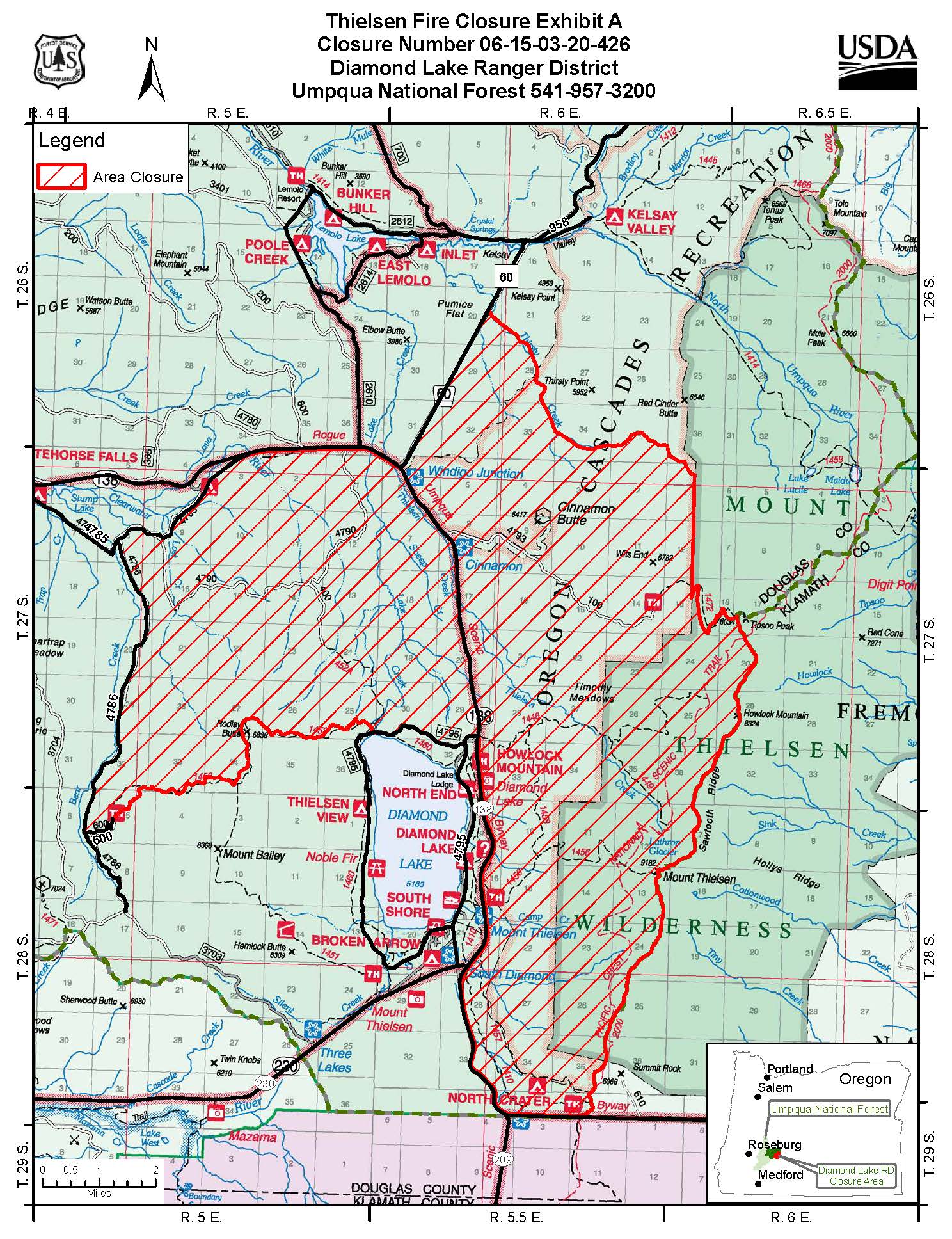
Umpqua National Forest – sections of the North Umpqua (North Umpqua Ranger District ORDER NO. 06-15-01-20-425) and Diamond Lake Districts (Diamond Lake Ranger District ORDER NO. 06-15-03-20-426) remain under a fire closure order. Umpqua Hot Springs, fire lookouts, cabins and group picnic sites remain closed. Diamond Lake Resort and Diamond Lake are now open for public recreation, but Diamond Lake Campground is closed for the rest of the year. North Umpqua District closure: https://inciweb.nwcg.gov/incident/article/7176/57090/ and Diamond Lake District closure: https://inciweb.nwcg.gov/incident/article/7195/57398/ More information on Forest Service closures is available at: https://www.fs.usda.gov/alerts/umpqua/alerts-notices The Umpqua National Forest is currently at Industrial Fire Precaution Level I. The fire danger is Moderate.
Temporary Flight Restriction: There is temporary flight restriction for aircraft, including drones, for the Archie Fire. No temporary flight restriction is in effect for the Thielsen Fire. Wildfires are No Drone Zones. If you fly, we can’t. For more information, visit http://knowbeforeyoufly.org/
Archie Creek and Thielsen Fire Update for October 4 2020
Related Incident:
Publication Type: News

Archie Creek and Thielsen Fires Update October 4, 2020
Incident Commander Mike Dueitt
Hours: 8 am-8 pm
Archie Creek Fire
Email: 2020.archiecreek@firenet.gov
Phone: 971-334-7674
InciWeb: https://inciweb.nwcg.gov/incident/7176/
Facebook: https://www.facebook.com/ArchieCreekFireInfo/
Thielsen Fire
Email: 2020.Thielsen@firenet.gov
Phone: 541-625-0687
InciWeb:https://inciweb.nwcg.gov/incident/7195/
Facebook: http://bit.ly/ThielsenFire
Special Notes: Smoldering logs and stumps in the interior of the fire will continue to put up smoke until winter rains end the fire season. Firefighters are patrolling the fire and will extinguish any hot spots that pose a threat to containment lines. Haze from California fires may be visible again today.
Areas within the fire perimeter are CLOSED to the public. Only residents and fire personnel are allowed in the area. Entry into the fire area is not only dangerous, but can endanger firefighters and their ability to do their work. Hazards include isolated hot spots and fire, heavy equipment and falling trees.
Today the Southern Area Red Team will meet with Pacific Northwest Team 12 Type 2 incident management team to begin transitioning management of the Archie Creek and Thielsen Fires. In preparation of that, an incident command post is being set up in Glide as the current command post moves out of the Douglas County Fairgrounds. Tomorrow Team 12 will shadow the Red Team and on Tuesday they will assume command of the fires.
Archie Creek Fire: The Archie Creek Fire is east of Roseburg in the North Umpqua corridor on state, private and federal land. It has burned 131,542 acres and is 86 percent contained. There are currently 605 personnel assigned. The cause of the fire is under investigation.
Personnel and Equipment: 16 Type 2 hand crews, 2 helicopters, 1 fixed wing air attack, 23 engines, 14 bulldozers, 9 water tenders, 3 masticators, 2 skidgines, 11 excavators, 6 chippers and 2 dump trucks.
The Southern Area Red Team continues to manage Archie Creek Fire operations on Umpqua National Forest lands and Oregon and California (O&C) lands managed by the Bureau of Land Management, while a Douglas Forest Protective Association local Type 3 incident management team, with Incident Commander Paul Ritter, continues to mop up and patrol firelines on private lands. The teams work collaboratively to protect homes, timber and other values.
Fire behavior will be minimal today as smoldering in stumps, dead trees and logs continues. Creeping fire may occur in areas where trees have dropped their needles or leaves, but no fire perimeter growth is expected. Firefighters will continue mopping up some areas, especially where there are indirect firelines, containment lines set back from the fire’s edge where burnable vegetation is between the fire and containment line. This is in the Zig Zag Creek and Trapper Creek areas on the northeast flank of the fire and steep areas in the southeast and south flanks. Firefighters are mostly transitioning to patrol. The largest remaining task is removing hazard trees along Rock Creek Road, Wright Creek and the Cool Water area to make these areas safe. As work is completed, firefighters and equipment are being released from the fire.
Crews will continue with suppression repair on Umpqua National Forest and Bureau of Land Management-managed lands. Chippers, excavators and dump trucks are repairing damage caused by fighting the fire, not for damage from the fire itself. Examples of suppression repair work in progress are installing water bars on firelines for proper drainage, especially on steep slopes. Crews are chipping brush along drainage ditches and hauling out trees felled to construct firelines. Suppression repair work is done in concert with agency resource advisors to meet resource protection standards.
Thielsen Fire: The Thielsen Fire is located five miles north of Crater Lake near Diamond Lake Resort. It has burned 9,975 acres and is 71 percent contained. There are currently 192 personnel assigned. Cause: unknown.
Personnel and Equipment: 3 Type 2 hand crews, 1 helicopter, 4 engines, 3 bulldozers, 6 water tenders, 2 skidders, 1 masticator, 4 excavators, 1 tub grinder and 5 dump trucks.
The fire continues to smolder in large stumps and deep duff with some isolated single tree torching. Yesterday fire crews conducted mop up and suppression repairs along containment lines. Today, mop up and suppression repairs will continue, and firefighters will continue improving a shaded fuel break along Forest Service Road 60.
Help for Fire Victims: Information on disaster aid and organizations helping victims of the Archie Creek Fire can be found at https://inciweb.nwcg.gov/incident/article/7176/57029/
Evacuations, Shelter Areas: An interactive map of the current evacuation area can be found at www.dcso.com/evacuations. For more evacuation information, visit the Douglas County Sheriff website www.dcso.com/evacuations and Facebook page at https://www.facebook.com/DouglasCoSO
The Douglas County Fairgrounds has full RV spaces, electric hookup spaces and dry camping available. They also have stalls and arenas for livestock and farm animals. Contact Ciera Keith at (541) 440-4394.
Air quality: See the Oregon Department of Environmental Quality at http://www.oregon.gov/deq
Closures:
-
Roads – Highway 138E is open, but delays should be expected. The route to Miller Lake via FS Road 9772 remains closed from the intersection with Hwy. 97 to the intersection with FS Road 110 due to firefighter traffic. Drivers are being directed to take FS Road 9774 to connect with FS Road 110 as an alternative route. See www.tripcheck.com for updates on highway closures.
-
Bureau of Land Management – All BLM-managed lands in the Swiftwater Resource Area east of the Willamette Meridan, Range 3 and 4 boundary line, and north of Little River Road are closed. This includes Rock Creek Road from the end of Douglas County road maintenance to the boundary of the Roseburg and Northwest Oregon BLM District line, and all BLM recreation sites in the closure boundary, including Rock Creek, Lone Pine, Millpond, Scaredman and Susan Creek campgrounds, and all BLM day use areas within the closure area. Cavitt Creek Falls Campground is closed for the season. For more information, see https://inciweb.nwcg.gov/incident/article/7176/57115/
-
Umpqua National Forest – sections of the North Umpqua (North Umpqua Ranger District ORDER NO. 06-15-01-20-425) and Diamond Lake Districts (Diamond Lake Ranger District ORDER NO. 06-15-03-20-426) remain under a fire closure order. Umpqua Hot Springs, fire lookouts, cabins and group picnic sites remain closed. Diamond Lake Resort and Diamond Lake are now open for public recreation, but Diamond Lake Campground is closed for the rest of the year. North Umpqua District closure: https://inciweb.nwcg.gov/incident/article/7176/57090/ and Diamond Lake District closure: https://inciweb.nwcg.gov/incident/article/7195/57398/ More information on Forest Service closures is available at: https://www.fs.usda.gov/alerts/umpqua/alerts-notices The Umpqua National Forest is currently at Industrial Fire Precaution Level I. The fire danger is Moderate.
Temporary Flight Restriction: There is temporary flight restriction for aircraft, including drones, for the Archie Fire. No temporary flight restriction is in effect for the Thielsen Fire. Wildfires are No Drone Zones. If you fly, we can’t. For more information, visit http://knowbeforeyoufly.org/
Archie Creek and Thielsen Fire Update for October 3 2020
Related Incident:
Publication Type: News
Archie Creek and Thielsen Fires Update October 3, 2020
Incident Commander Mike Dueitt
Hours: 8 am-8 pm
Archie Creek Fire
Email: 2020.archiecreek@firenet.gov
Phone: 971-334-7674
InciWeb: https://inciweb.nwcg.gov/incident/7176/
Facebook: https://www.facebook.com/ArchieCreekFireInfo/
Thielsen Fire
Email: 2020.Thielsen@firenet.gov
Phone: 541-625-0687
InciWeb:https://inciweb.nwcg.gov/incident/7195/
Facebook: http://bit.ly/ThielsenFire
Special Notes: Umpqua National Forest has reduced the size of the Thielsen Fire closure area. Diamond Lake Resort and Diamond Lake are now open for public recreation, but Diamond Lake Campground is closed for the rest of the year. Thielsen View Campground will be open from Monday, October 5, through October 28 on a first-come, first-served basis. No water is available at Thielsen View Campground, so please plan accordingly. Umpqua Hot Springs, fire lookouts, cabins, and group picnic sites remain closed. For more information and closure order map, see https://inciweb.nwcg.gov/incident/article/7195/57398/
Deer season opens today, so all forest users should be cautious as fire season continues. It is important to know what fire restrictions are in place before heading to the woods. Fire restrictions may vary between different agencies and districts. Locally, on the Douglas District of the Douglas Forest Protective Association, public use restrictions remain in effect on all private, county, state, Bureau of Land Management and Bureau of Indian Affairs lands that are protected by DFPA with a fire danger rating of Moderate. For more information, see www.dfpa.net or call DFPA’s 24-hour information line at 541-672-0379. The fire danger rating on Umpqua National Forest is also Moderate. For more information on Umpqua National Forest fire restrictions, please call 541-957-3200 or visit https://www.fs.usda.gov/umpqua/
Archie Creek Fire: The Archie Creek Fire is east of Roseburg in the North Umpqua corridor on state, private and federal land. It has burned 131,542 acres and is 81 percent contained. There are currently 672 personnel assigned. The cause of the fire is under investigation.
Personnel and Equipment: 17 Type-2 hand crews, 3 helicopters, 1 fixed wing air attack, 30 engines, 16 bulldozers, 11 water tenders, 3 masticators, 2 skidgines, 13 excavators, 7 chippers and 4 dump trucks.
Today is a day of change on the Archie Creek Fire, with command and leadership of the incident shifting as containment increases. The Southern Area Red Team continues to manage fire operations on Umpqua National Forest lands and Oregon and California (O&C) lands managed by the Bureau of Land Management, while fire operations on private lands returns to the Douglas Forest Protective Association. DFPA has created a local Type 3 Incident Management Team, with Incident Commander Paul Ritter, to continue mop up and patrol of firelines on private lands. Although administrative changes have been made, work on the ground continues to protect homes, timber and other values.
Upper level smoke from California fires shaded the fire again yesterday and may do so again today. Firefighters will continue mopping up some areas, but are mostly transitioning to patrol status. The largest remaining task is removing hazard trees along Rock Creek Road, Wright Creek and the Cool Water area to make these areas safe. As work is completed, firefighters and equipment are being released from the fire.
Crews will continue with suppression repair on Umpqua National Forest and Bureau of Land Management-managed lands. Chippers, excavators and dump trucks are being used to repair damage caused by fighting the fire, not for damage from the fire itself. Examples of suppression repair work in progress are installing water bars on firelines for proper drainage, especially on steep slopes. Crews are chipping brush along drainage ditches and hauling out trees felled to construct firelines. Suppression repair work is done in concert with agency resource advisors to meet resource protection standards.
Thielsen Fire: The Thielsen Fire is located five miles north of Crater Lake near Diamond Lake Resort. It has burned 9,975 acres and is 69 percent contained. There are currently 211 personnel assigned. Cause: unknown.
Personnel and Equipment: 4 Type-2 hand crews, 1 helicopter, 4 engines, 3 bulldozers, 6 water tenders, 2 skidders, 1 masticator, 4 excavators, 1 tub grinder and 5 dump trucks.
The fire continues to smolder in large stumps and deep duff. Yesterday fire crews conducted mop up and suppression repairs along containment lines. Today, mop up and suppression repairs will continue, and firefighters will continue improving a contingency line along Forest Service Road 60.
Help for Fire Victims: Information on disaster aid and organizations helping victims of the Archie Creek Fire can be found at https://inciweb.nwcg.gov/incident/article/7176/57029/
Evacuations, Shelter Areas: An interactive map of the current evacuation area can be found at www.dcso.com/evacuations. For more evacuation information, visit the Douglas County Sheriff website www.dcso.com/evacuations and Facebook page at https://www.facebook.com/DouglasCoSO
The Douglas County Fairgrounds has full RV spaces, electric hookup spaces and dry camping available. They also have stalls and arenas for livestock and farm animals. Contact Ciera Keith at (541) 440-4394.
Air quality: See the Oregon Department of Environmental Quality at http://www.oregon.gov/deq
Closures:
-
Roads – Highway 138E is open, but delays should be expected. The route to Miller Lake via FS Road 9772 remains closed from the intersection with Hwy. 97 to the intersection with FS Road 110 due to firefighter traffic. Drivers are being directed to take FS Road 9774 to connect with FS Road 110 as an alternative route. See www.tripcheck.com for updates on highway closures.
-
Bureau of Land Management – All BLM-managed lands in the Swiftwater Resource Area east of the Willamette Meridan, Range 3 and 4 boundary line, and north of Little River Road are closed. This includes Rock Creek Road from the end of Douglas County road maintenance to the boundary of the Roseburg and Northwest Oregon BLM District line, and all BLM recreation sites in the closure boundary, including Rock Creek, Lone Pine, Millpond, Scaredman and Susan Creek campgrounds, and all BLM day use areas within the closure area. Cavitt Creek Falls Campground is closed for the season. For more information, see https://inciweb.nwcg.gov/incident/article/7176/57115/
-
Umpqua National Forest – sections of the North Umpqua (North Umpqua Ranger District ORDER NO. 06-15-01-20-425) and Diamond Lake Districts (Diamond Lake Ranger District ORDER NO. 06-15-03-20-426) remain under a fire closure order. Umpqua Hot Springs, fire lookouts, cabins and group picnic sites remain closed. Diamond Lake Resort and Diamond Lake are now open for public recreation, but Diamond Lake Campground is closed for the rest of the year. North Umpqua District closure: https://inciweb.nwcg.gov/incident/article/7176/57090/ and Diamond Lake District closure: https://inciweb.nwcg.gov/incident/article/7195/57398/ More information on Forest Service closures is available at: https://www.fs.usda.gov/alerts/umpqua/alerts-notices The Umpqua National Forest is currently at Industrial Fire Precaution Level I. The fire danger is Moderate.
Temporary Flight Restriction: There are temporary flight restriction for aircraft, including drones, for the Archie Fire and the Thielsen Fire. The temporary flight restriction for Thielsen Fire will be removed at 8 pm tonight, October 3. Wildfires are a No Drone Zones. If you fly, we can’t. For more information, visit http://knowbeforeyoufly.org/
Umpqua National Forest Announces Reduction in Fire Closure Area
Related Incident:
Publication Type: Closures
Umpqua National Forest
Announces Reduction in Fire Closure Area
Diamond Lake Now Accessible
ROSEBURG, Ore., Oct. 2, 2020 Beginning at 00:01 Saturday, October 3, the Umpqua National Forest is reducing the size of the Thielsen Fire Closure area.
Diamond Lake Resort and Diamond Lake will now be outside of the fire closure area and will be available for the public seeking to recreate there (see closure order map 06-15-03-20-426). Diamond Lake Campground will not be available to the public and will remain closed for the remainder of the year though Thielsen View Campground will be available beginning Monday, Oct. 5 on a First Come-First Served basis only and will close on Oct. 28. There will be no water available at Thielsen View Campground so please plan accordingly.
The Umpqua Hot Springs, fire lookouts, cabins, and group picnic sites will all remain closed.
Most facilities, such as vault bathrooms, will remain open for public use. Members of the public wishing to utilize these facilities are doing so at their own discretion and must take all necessary precautions to account for their own personal health and safety. While we are following all CDC guidelines for the cleaning of public spaces we cannot guarantee a COVID free facility.
—30—
USDA is an equal opportunity provider, employer, and lender.

For a Printable Version
Archie Creek and Thielsen Fire Update for October 2 2020
Related Incident:
Publication Type: News
Archie Creek and Thielsen Fires Update October 2, 2020
Unified Incident Commanders Mike Dueitt and Tim Keith
Hours: 8 am-8 pm
Archie Creek Fire
Email: 2020.archiecreek@firenet.gov
Phone: 971-334-7674
InciWeb: https://inciweb.nwcg.gov/incident/7176/
Facebook: https://www.facebook.com/ArchieCreekFireInfo/
Thielsen Fire
Email: 2020.Thielsen@firenet.gov
Phone: 541-625-0687
InciWeb:https://inciweb.nwcg.gov/incident/7195/
Facebook: http://bit.ly/ThielsenFire
Special Notes: As hunters gear up for the opening of deer season tomorrow, all forest users should be cautious as fire season continues. It is important to know what fire restrictions are in place before heading to the woods. Fire restrictions may vary between different agencies and districts. Locally, on the Douglas District of the Douglas Forest Protective Association, public use restrictions remain in effect on all private, county, state, Bureau of Land Management and Bureau of Indian Affairs lands that are protected by DFPA with a fire danger rating of Moderate. For more information, see www.dfpa.net or call DFPA’s 24-hour information line at 541-672-0379. The fire danger rating on Umpqua National Forest is also Moderate. For more information on Umpqua National Forest fire restrictions, please call 541-957-3200 or visit https://www.fs.usda.gov/umpqua/.
The Oregon State University Extension Forestry program is compiling resources for forestland owners affected by the Archie Creek Fire. If your woodlot was damaged due to this fire or any of the 2020 wildfires in Douglas County, please contact Alicia Christiansen, OSU Extension Forestry Agent for Douglas County at (541) 236-3002 or alicia.christiansen@oregonstate.edu for information about salvage logging, soil erosion mitigation and financial or technical assistance.
Warm and dry weather may cause unburned pockets of live and dead vegetation, needle cast and piled logs and stumps throughout both fires to burn and produce smoke. Firefighters are keeping an eye out for flareups from the ground and from the air and will cool any threats to firelines. No fire growth is expected. Smoke from California fires may be visible.
Archie Creek Fire: The Archie Creek Fire is east of Roseburg in the North Umpqua corridor on state, private and federal land. It has burned 131,542 acres and is 79 percent contained. There are currently 716 personnel assigned. The cause of the fire is under investigation.
Personnel and Equipment: 17 Type 2 hand crews, 4 helicopters, 1 fixed wing air attack, 43 engines, 20 bulldozers, 14 water tenders, 3 masticators, 3 skidgines, 16 excavators, 5 chippers and 4 dump trucks.
Upper level smoke from California fires shaded the fire again yesterday and may do so again today. Firefighters will continue mopping up some areas, but are mostly transitioning to patrol status. Areas of patrol include homes and other buildings around Little River Road, Glide, Idleyld Park, Rock Creek and the Scott Mountain Area to Susan Creek. The largest remaining task is removing hazard trees along Rock Creek Road, Wright Creek and the Cool Water area to make these areas safe. As work is completed, firefighters and equipment are being released from the fire.
Crews will continue with suppression repair, which is almost complete in many areas. Chippers, excavators and dump trucks are being used to repair damage caused by fighting the fire, not for damage from the fire itself. Examples of suppression repair work in progress are installing water bars on firelines for proper drainage, especially on steep slopes. On Umpqua National Forest and Bureau of Land Management-managed Oregon & California (O&C) lands, crews are chipping brush along drainage ditches and hauling out trees felled to construct firelines. Suppression repair work is done in concert with agency resource advisors to meet resource protection standards. Smoke from the Archie Creek Fire will persist, mostly from scattered points of heat in the interior.
Thielsen Fire: The Thielsen Fire is located five miles north of Crater Lake near Diamond Lake Resort. It has burned 9,975 acres and is 69 percent contained. There are currently 227 personnel assigned. Cause: unknown.
Personnel and Equipment: 4 Type-2 hand crews, 1 helicopter, 7 engines, 3 bulldozers, 6 water tenders, 2 skidders, 1 masticator, 4 excavators, 1 tub grinder and 5 dump trucks.
The fire continues to smolder in large stumps and deep duff. Yesterday fire crews conducted mop up and suppression repairs along containment lines. Today, mop up and suppression repairs will continue, and firefighters will continue improving contingency lines along Forest Service Road 60.
Help for Fire Victims: Information on disaster aid and organizations helping victims of the Archie Creek Fire can be found at https://inciweb.nwcg.gov/incident/article/7176/57029/
Evacuations, Shelter Areas: An interactive map of the current evacuation area can be found at www.dcso.com/evacuations. For more evacuation information, visit the Douglas County Sheriff website www.dcso.com/evacuations and Facebook page at https://www.facebook.com/DouglasCoSO
The Douglas County Fairgrounds has full RV spaces, electric hookup spaces and dry camping available. They also have stalls and arenas for livestock and farm animals. Contact Ciera Keith at (541) 440-4394.
Air quality: See the Oregon Department of Environmental Quality at http://www.oregon.gov/deq
Closures:
Roads – Highway 138E is open, but delays should be expected. The route to Miller Lake via FS Road 9772 remains closed from the intersection with Hwy. 97 to the intersection with FS Road 110 due to firefighter traffic. Drivers are being directed to take FS Road 9774 to connect with FS Road 110 as an alternative route. See www.tripcheck.com for updates on highway closures.
Bureau of Land Management – All BLM-managed lands in the Swiftwater Resource Area east of the Willamette Meridan, Range 3 and 4 boundary line, and north of Little River Road are closed. This includes Rock Creek Road from the end of Douglas County road maintenance to the boundary of the Roseburg and Northwest Oregon BLM District line, and all BLM recreation sites in the closure boundary, including Rock Creek, Lone Pine, Millpond, Scaredman and Susan Creek campgrounds, and all BLM day use areas within the closure area. Cavitt Creek Falls Campground is closed for the season. For more information, see https://inciweb.nwcg.gov/incident/article/7176/57115/
Umpqua National Forest – sections of the North Umpqua (North Umpqua Ranger District ORDER NO. 06-15-01-20-425) and Diamond Lake Districts (Diamond Lake Ranger District ORDER NO. 06-15-01-20-424) remain under a fire closure order. Umpqua Hot Springs, fire lookouts, cabins and group picnic sites remain closed. See https://inciweb.nwcg.gov/incident/article/7176/57090/ More information on Forest Service closures are available at: https://www.fs.usda.gov/alerts/umpqua/alerts-notices
Temporary Flight Restriction: There are temporary flight restriction for aircraft, including drones, for the Archie Fire and the Thielsen Fire. Wildfires are a No Drone Zones. If you fly, we can’t. For more information, visit http://knowbeforeyoufly.org/
Archie Creek and Thielsen Fire Update for October 1 2020
Related Incident:
Publication Type: News
Archie Creek and Thielsen Fires Update October 1, 2020
Unified Incident Commanders Mike Dueitt and Tim Keith
Hours: 8 am-8 pm
Archie Creek Fire
Email: 2020.archiecreek@firenet.gov
Phone: 971-334-7674
InciWeb: https://inciweb.nwcg.gov/incident/7176/
Facebook: https://www.facebook.com/ArchieCreekFireInfo/
Thielsen Fire
Email: 2020.Thielsen@firenet.gov
Phone: 541-625-0687
InciWeb:https://inciweb.nwcg.gov/incident/7195/
Facebook: http://bit.ly/ThielsenFire
Special Notes: As hunters gear up for the opening of deer season on Saturday, all forest users should be cautious as fire season continues. It is important to know what fire restrictions are in place before heading to the woods. Fire restrictions may vary between different agencies and districts. Locally, on the Douglas District of the Douglas Forest Protective Association, Public Use Restrictions remain in effect on all private, county, state, Bureau of Land Management and Bureau of Indian Affairs lands that are protected by DFPA with a fire danger rating of Moderate. For more information, see www.dfpa.net or call DFPA’s 24 hour information line at 541-672-0379. The fire danger rating on Umpqua National Forest is also Moderate. For additional information on Umpqua National Forest fire restrictions, please call 541-957-3200 or visit https://www.fs.usda.gov/umpqua/.
Oregon State University Extension Service Fire Program is hosting a post-fire webinar today from 3-5 pm for residents affected by wildfires, including information on technical/financial assistance. Registration: https://oregonstate.zoom.us/webinar/register/WN_3J8OS8dWTDGOXC5YHy1TtQ
Warm and dry weather will cause unburned pockets of live and dead vegetation, needle cast and piled logs and stumps throughout both fires to burn and produce smoke. Firefighters are keeping an eye out for increased fire behavior from the ground and from the air and will cool any threats to firelines. No fire growth is expected. Smoke from California fires may be visible at upper air levels.
Archie Creek Fire: The Archie Creek Fire is east of Roseburg in the North Umpqua corridor on state, private and federal land. It has burned 131,542 acres and is 76 percent contained. There are currently 789 personnel assigned. The cause of the fire is under investigation.
Personnel and Equipment: 18 Type 2 hand crews, 4 helicopters, 1 fixed wing air attack, 53 engines, 23 bulldozers, 15 water tenders, 3 masticators, 5 skidgines, 16 excavators, 5 chippers and 4 dump trucks.
Upper level smoke from California fires shaded the fire, keeping temperatures lower than expected, so firefighters made good progress mopping up. Last night an infrared flight showed many isolated points of heat scattered throughout the fire and yesterday firefighters observed small flareups on the east flank of the fire where needles fallen from burnt trees ignited in those isolated heat sources. These were in the fire interior and posed no threat to firelines. Upper level smoke is expected to persist today, and firefighters will continue to patrol, mop up, make sure firelines are cold, backhaul fire hose and other equipment and assess and continue suppression repair. Firefighters will patrol and mop up along buildings throughout the fire, including along Little River Road, Glide, Idleyld Park, Rock Creek and the Scott Mountain Area to Susan Creek. They will continue removing hazard trees along Rock Creek Road, Wright Creek and Cool Water area to make these areas safe. Yesterday, crews removed a boulder the size of a bus from an interior road on the east side of the fire to allow access. With burned tree roots, burned soil and rain last week, the boulder rolled into the road.
Chippers, excavators and dump trucks continue to do suppression repair. Suppression repair ensures actions taken to fight the fire do not have long-term impacts on natural resources. Examples of suppression repair work in progress include installing water bars on firelines (especially on steep slopes) for proper drainage. On Umpqua National Forest and Bureau of Land Management-managed lands, crews are chipping brush along drainage ditches and hauling out trees felled to construct firelines. Suppression repair work is done in concert with agency resource advisors to meet resource protection standards. Fire suppression repair is for damage caused fighting the fire, not for damage from the fire itself.
Thielsen Fire: The Thielsen Fire is located five miles north of Crater Lake near Diamond Lake Resort. It has burned 9,974 acres and is 69 percent contained. There are currently 208 personnel assigned. Cause: unknown.
Personnel and Equipment: 4 Type-2 hand crews, 1 helicopter, 5 engines, 2 bulldozers and 6 water tenders.
Multiple days of dry weather has allowed further smoldering in deep duff and dead vegetation, but minimal winds will help keep fire activity down today. Yesterday fire crews conducted mop up and suppression repairs along containment lines and finished removing all hoses and appliances. Cinnamon Butte Road was also graded to improve road conditions. Today, mop up and suppression repairs will continue, and firefighters will continue improving contingency lines along Forest Service Road 60.
Help for Fire Victims: Information on disaster aid and organizations helping victims of the Archie Creek Fire can be found at https://inciweb.nwcg.gov/incident/article/7176/57029/
Evacuations, Shelter Areas: An interactive map of the current evacuation area can be found at www.dcso.com/evacuations. For more evacuation information, visit the Douglas County Sheriff website www.dcso.com/evacuations and Facebook page at https://www.facebook.com/DouglasCoSO
The Douglas County Fairgrounds has full RV spaces, electric hookup spaces and dry camping available. They also have stalls and arenas for livestock and farm animals. Contact Ciera Keith at (541) 440-4394.
Air quality: See the Oregon Department of Environmental Quality at http://www.oregon.gov/deq
Closures:
Roads – Highway 138E is open, but delays should be expected. The route to Miller Lake via FS Road 9772 remains closed from the intersection with Hwy. 97 to the intersection with FS Road 110 due to firefighter traffic. Drivers are being directed to take FS Road 9774 to connect with FS Road 110 as an alternative route. See www.tripcheck.com for updates on highway closures.
Bureau of Land Management – All BLM-managed lands in the Swiftwater Resource Area east of the Willamette Meridan, Range 3 and 4 boundary line, and north of Little River Road are closed. This includes Rock Creek Road from the end of Douglas County road maintenance to the boundary of the Roseburg and Northwest Oregon BLM District line, and all BLM recreation sites in the closure boundary, including Rock Creek, Lone Pine, Millpond, Scaredman and Susan Creek campgrounds, and all BLM day use areas within the closure area. Cavitt Creek Falls Campground is closed for the season. For more information, see https://inciweb.nwcg.gov/incident/article/7176/57115/
Umpqua National Forest – sections of the North Umpqua (North Umpqua Ranger District ORDER NO. 06-15-01-20-425) and Diamond Lake Districts (Diamond Lake Ranger District ORDER NO. 06-15-01-20-424) remain under a fire closure order. Umpqua Hot Springs, fire lookouts, cabins and group picnic sites remain closed. See https://inciweb.nwcg.gov/incident/article/7176/57090/ More information on Forest Service closures are available at: https://www.fs.usda.gov/alerts/umpqua/alerts-notices
Temporary Flight Restriction: There are temporary flight restriction for aircraft, including drones, for the Archie Fire and the Thielsen Fire. Wildfires are a No Drone Zones. If you fly, we can’t. For more information, visit http://knowbeforeyoufly.org/
Archie Creek and Thielsen Fire Update for September 30 2020
Related Incident:
Publication Type: News
Archie Creek and Thielsen Fires Update September 30, 2020
Unified Incident Commanders Mike Dueitt and Tim Keith
Hours: 8 am-8 pm
Archie Creek Fire
Email: 2020.archiecreek@firenet.gov
Phone: 971-334-7674
InciWeb: https://inciweb.nwcg.gov/incident/7176/
Facebook: https://www.facebook.com/ArchieCreekFireInfo/
Thielsen Fire
Email: 2020.Thielsen@firenet.gov
Phone: 541-625-0687
InciWeb:https://inciweb.nwcg.gov/incident/7195/
Facebook: http://bit.ly/ThielsenFire
Special Notes: The Douglas Forest Protective Association will increase the Industrial Fire Precaution Level to IFPL II (two) on all private, county, state, Bureau of Land Management and Bureau of Indian Affairs lands that are protected by DFPA. The increase to IFPL II will take effect tomorrow, October 1st, at 12:01 AM.
Dry and warm weather with near record high temperatures will persist through tomorrow and cause unburned pockets of live and dead vegetation, needle cast and piled logs and stumps throughout both fires to burn and produce smoke. Firefighters are keeping an eye out for increased fire behavior from the ground and from the air and will cool any threats to firelines. No fire growth is expected. Smoke from California fires may be visible at upper air levels.
Oregon State University Extension Service Fire Program is hosting a post-fire webinar tomorrow, October 1st from 3-5 pm for residents affected by wildfires, including information on technical/financial assistance. Registration: https://oregonstate.zoom.us/webinar/register/WN_3J8OS8dWTDGOXC5YHy1TtQ
Archie Creek Fire: The Archie Creek Fire is east of Roseburg in the North Umpqua corridor on state, private and federal land. It has burned 131,542 acres and is 73 percent contained. There are currently 836 personnel assigned. The cause of the fire is under investigation.
Personnel and Equipment: 20 Type 2 hand crews, 4 helicopters, 1 fixed wing air attack, 53 engines, 23 bulldozers, 17 water tenders, 3 masticators, 5 skidgines, 14 excavators, 5 chippers, and 11 dump trucks.
With yesterday’s hot and dry weather, a hot spot flared up in steep ground on the northeast flank of the fire in the Zig Zag Creek and upper Trapper Creek areas. Helicopters dropped water on the flareups to cool them down. Today firefighters will continue to patrol, mop up, make sure firelines are cold, backhaul fire hose and other equipment and assess and continue suppression repair. Firefighters will patrol and mop up around buildings throughout the fire, including along Little River Road, Glide, Idleyld Park, Rock Creek and the Scott Mountain Area to Susan Creek.
Firefighters will continue removing hazard trees along Rock Creek Road, Wright Creek and Cool Water area to make areas safe. Crews are monitoring the northeastern flank of the fire in the Zig Zag Creek and Upper Trapper Creek areas and will use helicopters to make water drops as necessary.
Chippers, excavators and dump trucks are on hand to do suppression repair as conditions allow. Suppression repair ensures actions taken to fight the fire do not have long-term impacts on natural resources. Examples of suppression repair work that has begun are installing water bars on firelines (especially on steep slopes) for proper drainage. On Umpqua National Forest and Bureau of Land Management-managed lands, crews are chipping brush along drainage ditches and hauling out trees felled to construct firelines. Suppression repair work is done in concert with agency resource advisors to meet resource protection standards. Fire suppression repair is for damage caused fighting the fire, not for damage from the fire itself.
Thielsen Fire: The Thielsen Fire is located five miles north of Crater Lake near Diamond Lake Resort. It has burned 9,974 acres and is 69 percent contained. There are currently 255 personnel assigned. Cause: unknown.
Personnel and Equipment: 5 Type 2 hand crews, 2 helicopters, 8 engines, 6 bulldozers, 6 water tenders and 1 masticator.
Gradual drying has allowed stumps and logs to begin smoldering more now that fuels are drying. Yesterday fire crews conducted mop up and suppression repairs along containment lines, and this work will continue today. Firefighters will continue felling hazard trees along Cinnamon Butte Road and improving contingency lines along Forest Service Road 60.
Help for Fire Victims: Information on disaster aid and organizations helping victims of the Archie Creek Fire can be found at https://inciweb.nwcg.gov/incident/article/7176/57029/
Evacuations, Shelter Areas: An interactive map of the current evacuation area can be found at www.dcso.com/evacuations. For more evacuation information, visit the Douglas County Sheriff website www.dcso.com/evacuations and Facebook page at https://www.facebook.com/DouglasCoSO
The Douglas County Fairgrounds has full RV spaces, electric hookup spaces and dry camping available. They also have stalls and arenas for livestock and farm animals. Contact Ciera Keith at (541) 440-4394.
Air quality: See the Oregon Department of Environmental Quality at http://www.oregon.gov/deq
Closures:
Roads – Highway 138E is open, but delays should be expected. The route to Miller Lake via FS Road 9772 remains closed from the intersection with Hwy. 97 to the intersection with FS Road 110 due to firefighter traffic. Drivers are being directed to take FS Road 9774 to connect with FS Road 110 as an alternative route. See www.tripcheck.com for updates on highway closures.
Bureau of Land Management – All BLM-managed lands in the Swiftwater Resource Area east of the Willamette Meridan, Range 3 and 4 boundary line, and north of Little River Road are closed. This includes Rock Creek Road from the end of Douglas County road maintenance to the boundary of the Roseburg and Northwest Oregon BLM District line, and all BLM recreation sites in the closure boundary, including Rock Creek, Lone Pine, Millpond, Scaredman and Susan Creek campgrounds, and all BLM day use areas within the closure area. Cavitt Creek Falls Campground is closed for the season. For more information, see https://inciweb.nwcg.gov/incident/article/7176/57115/
Umpqua National Forest – sections of the North Umpqua (North Umpqua Ranger District ORDER NO. 06-15-01-20-425) and Diamond Lake Districts (Diamond Lake Ranger District ORDER NO. 06-15-01-20-424) remain under a fire closure order. Umpqua Hot Springs, fire lookouts, cabins and group picnic sites remain closed. See https://inciweb.nwcg.gov/incident/article/7176/57090/ More information on Forest Service closures are available at: https://www.fs.usda.gov/alerts/umpqua/alerts-notices
The Umpqua National Forest is currently at Industrial Fire Precaution Level I. The fire danger is Moderate.
Temporary Flight Restriction: There are temporary flight restriction for aircraft, including drones, for the Archie Fire and the Thielsen Fire. Wildfires are a No Drone Zones. If you fly, we can’t. For more information, visit http://knowbeforeyoufly.org/
Thielsen Fire Operations Briefing Videos
Related Incident:
Publication Type: News
The Southern Area Red Team daily Operational briefings for Thielsen Fire.
See Article Related Links:
10/04/2020 - Operations Briefing
10/03/2020 - Operations Briefing
10/02/2020 - Operations Briefing
10/01/2020 - Operations Briefing
09/30/2020 - Operations Briefing
09/29/2020 - Operations Briefing
09/27/2020 - Operations Briefing
Archie Creek and Thielsen Fire Update for September 29 2020
Related Incident:
Publication Type: News
Archie Creek and Thielsen Fires Update September 29, 2020
Unified Incident Commanders Mike Dueitt and Tim Keith
Hours: 8 am-8 pm
Archie Creek Fire
Email: 2020.archiecreek@firenet.gov
Phone: 971-334-7674
InciWeb: https://inciweb.nwcg.gov/incident/7176/
Facebook: https://www.facebook.com/ArchieCreekFireInfo/
Thielsen Fire
Email: 2020.Thielsen@firenet.gov
Phone: 541-625-0687 NEW
InciWeb:https://inciweb.nwcg.gov/incident/7195/
Facebook: http://bit.ly/ThielsenFire
Special Notes: The Bureau of Land Management Roseburg District has modified the closure order of public lands east of I-5, within the Swiftwater Resource Area. Access to public lands west of Glide, including the North Bank Habitat Management Area, is now permitted. A map of the closure perimeter and more information can be found at https://inciweb.nwcg.gov/incident/article/7176/57115/.
Dry and warm weather with near record high temperatures will persist through Thursday and cause unburned pockets of live and dead vegetation, needle cast and piled logs and stumps throughout both fires to burn and produce smoke. Firefighters are keeping an eye out for increased fire behavior from the ground and from the air and will cool any threats to firelines. No fire growth is expected.
The Douglas County Sheriff's Office announced the following evacuation level reductions: The LEVEL 1 "BE READY" notice on Little River Road at New Bridge Road to the end of Little River Road, including all side streets between these two points, has been lifted. This area is no longer under a formal evacuation notice. Diamond Lake, including the Diamond Lake Resort, all recreation areas and all residential and summer homes has been reduced to a LEVEL 1 "BE READY" notice.
Warm and dry conditions in Umpqua Valley have prompted the Douglas Forest Protective Association to increase the Fire Danger to Moderate. The Industrial Fire Precaution Level remains at IFPL I, district wide.
Oregon State University Extension Service Fire Program is hosting a post-fire webinar this Thursday, October 1st from 3-5 pm for residents affected by wildfires, including information on technical/financial assistance. Registration: https://oregonstate.zoom.us/webinar/register/WN_3J8OS8dWTDGOXC5YHy1TtQ
Archie Creek Fire: The Archie Creek Fire is east of Roseburg in the North Umpqua corridor on state, private and federal land. It has burned 131,542 acres and is 72 percent contained. There are currently 863 personnel assigned. The cause of the fire is under investigation.
Personnel and Equipment: 20 Type 2 hand crews, 5 helicopters, 1 fixed wing air attack, 56 engines, 20 bulldozers, 20 water tenders, 4 masticators, and 5 skidgines.
Today firefighters will continue to patrol, mop up, make sure firelines are cold, backhaul fire hose and other equipment and assess and continue suppression repair. Hand crews will construct remaining firelines directly at the fire’s edge, where necessary and accessible. Firefighters continue to protect homes and other buildings throughout the fire, including along Little River Road and they are assessing structure protection for the Bar L subdivision. Other areas protected are Wolf Creek Job Corps, Susan Creek Bridge and communications equipment on Scott Mt. Firefighters will also remove hazard trees along the Rock Creek Road corridor and in the Wright Creek area to make them safe for travel.
Chippers, excavators and dump trucks are on hand to do suppression repair as conditions allow. Suppression repair ensures actions taken to fight the fire do not have long-term impacts on natural resources. Examples of suppression repair work that has begun are installing water bars on firelines (especially on steep slopes) for proper drainage. On Umpqua National Forest and Bureau of Land Management-managed lands, crews are chipping brush along drainage ditches and hauling out trees felled to construct firelines. Suppression repair work is done in concert with agency resource advisors to meet resource protection standards. Fire suppression repair is for damage caused fighting the fire, not for damage from the fire itself.
Thielsen Fire: The Thielsen Fire is located five miles north of Crater Lake near Diamond Lake Resort. It has burned 9,971acres and is 69 percent contained. There are currently 302 personnel assigned. Cause: unknown.
Personnel and Equipment: 6 Type 2 hand crews, 2 helicopters, 13 engines, 6 bulldozers, 9 water tenders and 1 masticator.
Yesterday on the east side of the fire, crews continued to construct handlines near the Wilderness boundary and mop up where possible. On the west side, firefighters continued to secure and mop up containment lines. Today, crews will continue mop up and work with resource advisors to start suppression repairs. Firefighters will also continue improving potential containment contingency lines along Forest Service Road 60.
Help for Fire Victims: Information on disaster aid and organizations helping victims of the Archie Creek Fire can be found at https://inciweb.nwcg.gov/incident/article/7176/57029/
Evacuations, Shelter Areas: An interactive map of the current evacuation area can be found at www.dcso.com/evacuations. For more evacuation information, visit the Douglas County Sheriff website www.dcso.com/evacuations and Facebook page at https://www.facebook.com/DouglasCoSO
The Douglas County Fairgrounds has full RV spaces, electric hookup spaces and dry camping available. They also have stalls and arenas for livestock and farm animals. Contact Ciera Keith at (541) 440-4394.
Air quality: See the Oregon Department of Environmental Quality at http://www.oregon.gov/deq
Closures:
Roads – Highway 138E is open, but delays should be expected. The route to Miller Lake via FS Road 9772 remains closed from the intersection with Hwy. 97 to the intersection with FS Road 110 due to firefighter traffic. Drivers are being directed to take FS Road 9774 to connect with FS Road 110 as an alternative route. See www.tripcheck.com for updates on highway closures.
Bureau of Land Management – All BLM-managed lands in the Swiftwater Resource Area east of the Willamette Meridan, Range 3 and 4 boundary line, and north of Little River Road are closed. This includes Rock Creek Road from the end of Douglas County road maintenance to the boundary of the Roseburg and Northwest Oregon BLM District line, and all BLM recreation sites in the closure boundary, including Rock Creek, Lone Pine, Millpond, Scaredman and Susan Creek campgrounds, and all BLM day use areas within the closure area. Cavitt Creek Falls Campground is closed for the season. For more information, see https://inciweb.nwcg.gov/incident/article/7176/57115/
Umpqua National Forest – sections of the North Umpqua (North Umpqua Ranger District ORDER NO. 06-15-01-20-425) and Diamond Lake Districts (Diamond Lake Ranger District ORDER NO. 06-15-01-20-424) remain under a fire closure order. Umpqua Hot Springs, fire lookouts, cabins and group picnic sites remain closed. See https://inciweb.nwcg.gov/incident/article/7176/57090/ More information on Forest Service closures are available at: https://www.fs.usda.gov/alerts/umpqua/alerts-notices
The Umpqua National Forest is currently at Industrial Fire Precaution Level I. The fire danger is Moderate.
Temporary Flight Restriction: There are temporary flight restriction for aircraft, including drones, for the Archie Fire and the Thielsen Fire. Wildfires are a No Drone Zones. If you fly, we can’t. For more information, visit http://knowbeforeyoufly.org/
Archie Creek and Thielsen Fire Update for September 28 2020
Related Incident:
Publication Type: News
