
TERMINATED Road Area and Trail Closure Boise National Forest
Related Incident:
Publication Type: Closures
PROHIBITION:
2. Being on the Closed Roads. 36 CFR § 261.54(e).
EXEMPTIONS:
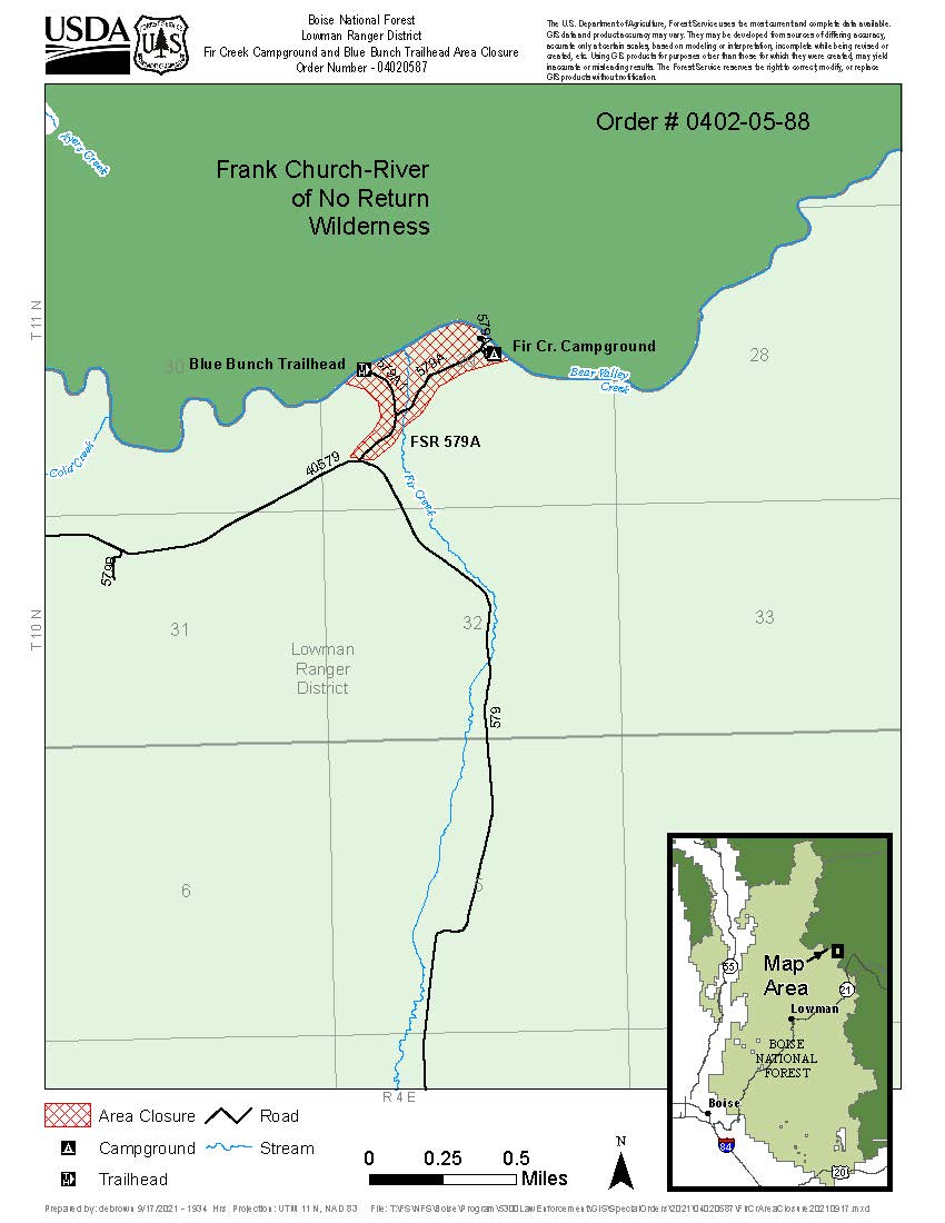
CLOSED AREA AND CLOSED ROADS DESCRIPTION
PURPOSE
The Boundary Fire breached a management action point that prompted the emergency closure of the Fir Creek Campground for public health and safety. The adjacent portion of the Frank Church-River of No Return is also closed due to the Boundary Fire (Salmon Challis National Forest Closure Order Number: 04-13-21-015)
IMPLEMENTATION
1. This Order will be in effect when signed and shall remain in effect until October 31, 2021, unless rescinded earlier by the Forest Supervisor. 2. A map identifying the Closed Area and Closed Roads is attached to and made part of this Order. 3. A violation of the above prohibitions is punishable by a fine of not more than $5,000 for an individual, or $10,000 for an organization, and/or imprisonment for not more than 6 months. [16 USC § 551, 18 USC §§ 3559, 3571, 3581] 4. Further information regarding this Order may be obtained at the Lowman Ranger District Office, (208) 259-3361, and the Boise National Forest Supervisor’s Office, (208) 373-4007. Done at Boise, Idaho this _20_ day of September 2021.
September 25 Update for Boundary Fire
Related Incident:
Publication Type: News
September 24 Boundary Fire Update
Related Incident:
Publication Type: News
The Salmon-Challis National Forest Boundary Fire Emergency Area, Road and Trail Closure Order #04-13-21-015 has been reduced in size to exclude the southwest portion of the Wilderness.
A point protection strategy is being applied to the Boundary Creek Fire, which is burning in the Frank Church River of No Return Wilderness. Firefighter and public safety remain the number one priority.
Sulphur Group – Crews extinguished two small spot fires just west of Sulphur Creek Ranch; firefighters will grid for any other possible spots today. Four miles of the shaded fuel break along the 579 Road has been completed, and two additional chippers arrived to help with slash work.
In the Seafoam Group, smoke was visible over the ridge of Lime Creek yesterday afternoon. Firefighters scouted a trail to Lost Packer Mine for a possible contingency line. Contingency plans are being created for Lost Packer Mine and Loon Creek areas. Snagging along main travel corridor and backhaul of pumps and other equipment will occur today.
CLOSURES and RESTRICTIONS: Fire managers are asking the public to please stay out of all closure areas. The Salmon-Challis National Forest closure area and map can be viewed on their website. Rafters with a Middle Fork of the Salmon launch permit can contact 208-879-4108 for information about how closures will impact their trips. Boundary Creek, Indian Creek, and Thomas Creek launch sites are closed to boaters until further notice. Hunters with special permits within the closure area are encouraged to call the Salmon office of Idaho Fish and Game at 208-756-2271 and visit their website at http://idfg.idaho.gov.
A temporary flight restriction (TFR) is in effect over the fire for public and firefighter safety. The surrounding backcountry airstrips remain open to general aviation; pilots should coordinate with Central Idaho Dispatch, and monitor both the TFR and backcountry frequencies.
Information on wildfire smoke can be found at http://idsmoke.blogspot.com/. For air quality information, visit https://www2.deq.idaho.gov/air/AQIPublic/Forecast, then select Idaho Falls Region. Salmon is in the dropdown menu.
Facebook: https://www.facebook.com/salmonchallisnf Inciweb: https://inciweb.nwcg.gov/incident/7795/ Follow us on Twitter @salmonchallisnf
Terminated Updated Closure Order
Related Incident:
Publication Type: Closures
The Salmon‐Challis National Forest has reduced the Boundary Fire Emergency Area, Road, and Trail Closure, Order Number: 04‐13‐21‐015.Description of Closed Area, Roads, and Trails (#04‐13‐21‐015).
Closed Area: All NFS lands in the Middle Fork District of the Salmon‐Challis National Forest in the area bounded at the junction of the Frank Church River of No Return Wilderness Area (FCNOR Wilderness Area) boundary and National Forest System Road (NFSR) #550Artillery Dome Road, then following the FCNOR Wilderness Area boundary south to the junction of National Forest System Trail (NFST)#4231 West Fork of Elk Creek Trail, then following NFST #4231 West Fork of Elk Creek Trail to its junction with the FCNOR Wilderness Boundary, then following the FCNOR Wilderness Boundary east to the junction of National Forest System Trail (NFST) #4028 Mountain Meadows Trail and NFSR #583 Bear Valley Mountain Lookout Road, then following a straight line southeast to NFSR #568 Dagger Falls Road, then following east and north along the FCNOR Wilderness Area boundary to its junction with NFSR #172 Beaver‐Loon Road, then following the FCNOR Wilderness Area boundary along both side of NFSR #172 Beaver Loon Road to its junction with NFST #4115 Rat Creek Trail, then following the FCNOR Wilderness Area boundary on the north side of Lost Packer Mine to its junction with NFST #4011Blue Lake Trail, the following NFST #4011 Blue Lake Trail and NFST #4004 Little Loon Trail to its junction with the Middle Fork of the Salmon River, then following a direct line north to its junction with Mahoney Creek, then following a straight line west to its junction with Middle Fork of the Salmon River, then following south and west on the Middle Fork of the Salmon River to its junction with Elkhorn Creek, then following east on Elkhorn Creek to the point of origin at the junction of the FCNOR Wilderness Area boundary and NFSR#550Artillery Dome Road.
Closed Roads and Trails: All NFS roads (NFSR) and trails (NFST) within the Closed Area.
The purpose of the order is to protect public health and safety from the effects of the Boundary Fire. Public and firefighter safety is the number one priority for the Boundary Fire.
The order will be in effect when signed and shall remain in effect until rescinded.
September 23 Boundary Fire Update
Related Incident:
Publication Type: News
A point protection strategy is being applied to the Boundary Creek Fire. Firefighter and public safety remain the number one priority.
In the Sulphur Group, Boundary Creek recreation and administrative sites have been secured and all point protection equipment has been removed. A small contingent of firefighters remain at Sulphur Creek Ranch as the fire is still active in a heavy snag patch on the south side of the ranch. Heat is still present on the southern perimeter of the fire, so crews are continuing fuel reduction work along the 579 Road.
Seafoam Group - Float Creek Bridge has been secured and the water handling equipment used to protect it has been removed and backhauled to base camp. The rain from Sunday abated the immediate threat to Seafoam Guard Station, but the pumps and hoses remain in place. Contingency plans are being considered for Lost Packer Mine and Loon Creek area.
Scarface Group - Middle Fork Ranch and the Little Creek Guard Station have been secured but will be patrolled for the next few days to check for smokes. Crews are assessing gear and equipment that can be backhauled. Cougar Creek Ranch was assessed for point protection needs in case winds push the fire closer to that property.
Pistol Group - Firefighters fortified and cleaned an existing hand line around Pistol Creek Ranch and Indian Creek Guard Station. Pumps are being staged in preparation for a hoselay if needed to protect these values at risk.
Weather –Temperatures over much of the fire area will reach mid- to high 60s. Relative humidity will be 20 percent. Winds will be primarily out of the northwest between 3-8 mph. Dry stable air will remain for a couple more days, with warming temperatures.
CLOSURES and RESTRICTIONS: On the Salmon-Challis National Forest, the Boundary Fire Emergency Area, Road and Trail Closure, Order #04-13-21-015 is in place to protect public health and safety. Fire managers are asking the public to please stay out of the closure area. Forest Road #172, the access for Pinyon Peak Lookout, is included in the closure. The closure area and map can be viewed on the Salmon-Challis National Forest website. Rafters with a Middle Fork of the Salmon launch permit can contact 208-879-4108 for information about how closures will impact their trips. Boundary Creek, Indian Creek, and Thomas Creek launch sites are closed to boaters until further notice.
On the Boise National Forest, the Area and Road Closure for Fir Creek Campground and Blue Bunch Trailhead, Order #0402-05-88, is in effect for the areas surrounding Forest Service Roads 579A and 579A1. The closure order and map may be viewed on the Boise National Forest website.
Hunters with special permits within the closure area are encouraged to call the Salmon office of Idaho Fish and Game at 208-756-2271 and visit their website at http://idfg.idaho.gov.
A temporary flight restriction (TFR) is in effect over the fire for public and firefighter safety. The surrounding backcountry airstrips remain open to general aviation; pilots should coordinate with Central Idaho Dispatch, and monitor both the TFR and backcountry frequencies.
Information on wildfire smoke can be found at http://idsmoke.blogspot.com/. For air quality information, visit https://www2.deq.idaho.gov/air/AQIPublic/Forecast, then select Idaho Falls Region. Salmon is in the dropdown menu.
Facebook: https://www.facebook.com/salmonchallisnf Inciweb: https://inciweb.nwcg.gov/incident/7795/ Follow us on Twitter @salmonchallisnf
Upper Middle Fork launch closures
Related Incident:
Publication Type: Announcement
Boundary Creek, Indian Creek, and Thomas Creek launch sites are closed to boaters until further notice. The Salmon Challis anticipates opening Thomas Creek launch site on Monday, September 27th. There are trees down in the river downstream from Thomas Creek which may necessitate a portage.
September 22 2021 Boundary Fire Update
Related Incident:
Publication Type: News
Weather – Breezy conditions expected today ahead of an approaching cold front. Temperatures over much of the fire area will reach mid- to high 60s except in the Thomas Creek area, where temperatures will near 80. In valleys and drainages, winds will be between 5-10 mph with gusts up to 25 mph. Ridgetop winds will be 8-12 mph with gusts up to 15 mph. The warming and drying trend will continue for the remainder of the week.
The Boundary Fire is burning in steep and inaccessible terrain in the Frank Church River of No Return Wilderness (FCRNRW), on the Middle Fork Ranger District of the Salmon-Challis National Forest and the Lowman Ranger District of the Boise National Forest. Firefighter and public safety remain the number one priority.
An infrared flight provided an updated footprint for the fire, which grew by approximately 6,000 acres.
The Sulphur Group pulled excess equipment from the Boundary Creek recreation and administrative sites yesterday. Crews continued fuel reduction work along the 579 Road, and this work continues today. Firefighters will also continue to protect Sulphur Creek Ranch as fire behavior is expected to increase with warmer temperatures and lower humidity.
Heat remains in Seafoam Creek, but the Seafoam Group saw no significant fire activity Tuesday. Crews confirmed that Fontez and Mountain King Mines are secure. As increased fire behavior is expected around Greyhound Mine, firefighters stand ready to protect it.
Scarface Group mopped up and secured the area above Middle Fork Ranch, and this work will continue today. Crews completed inventory of equipment and gear and will prepare excess equipment for backhaul. Firefighters also inspected equipment at Cougar Creek Ranch to ensure it is protected if winds push the fire closer to the value.
Additional firefighters were flown in to support the Pistol Group. Firefighters set up pumps and laid hose in support of the structure protection plan for Pistol Creek Ranch. Tomorrow, crews will continue this work and begin reinforcing existing handlines around Indian Creek Guard Station by removing needle fall.
CLOSURES and RESTRICTIONS:
On the Salmon-Challis National Forest, the Boundary Fire Emergency Area, Road and Trail Closure, Order #04-13-21-015 is in place to protect public health and safety. Fire managers are asking the public to please stay out of the closure area. Forest Road #172, the access for Pinyon Peak Lookout, is included in the closure. The closure area and map can be views on the Salmon-Challis National Forest website. Rafters with a Middle Fork of the Salmon launch permit can contact 208-879-4108 for information about how closures will impact their trips. Boundary Creek, Indian Creek, and Thomas Creek launch sites are closed to boaters until further notice.
Hunters with special permits within the closure area are encouraged to call the Salmon office of Idaho Fish and Game at 208-756-2271 and visit their website at http://idfg.idaho.gov.
On the Boise National Forest, the Area and Road Closure for Fir Creek Campground and Blue Bunch Trailhead, Order #0402-05-88, is in effect for the areas surrounding Forest Service Roads 579A and 579A1. The closure order and map may be viewed on the Boise National Forest website.
A temporary flight restriction (TFR) is in effect daily for public and firefighter safety.
Information on wildfire smoke can be found at http://idsmoke.blogspot.com/. For air quality information, visit https://www2.deq.idaho.gov/air/AQIPublic/Forecast, then select Idaho Falls Region. Salmon is located in the drop down menu.
September 21 Boundary Fire Update
Related Incident:
Publication Type: News
Weather – mostly sunny with daytime temperatures in the low to mid-60s and RH near 25%. Winds will be light, shifting from northwest to south-southwest. Expect a warming trend for the remainder of the week with a return to low RHs resulting in the potential for increased fire behavior. Low clouds and fog the next few days may restrict air operations.
The Boundary Fire is burning in steep and inaccessible terrain in the Frank Church River of No Return Wilderness (FCRONRW), on the Middle Fork Ranger District of the Salmon-Challis National Forest and the Lowman Ranger District of the Boise National Forest. Firefighter and public safety remain the number one priority.
The Sulphur Group mopped up hot spots around the Sulphur Creek Ranch yesterday. Two miles of road prep for a contingency line have been completed along the 579 Road. Reduced heat allowed for scouting contingency options for the Boise National Forest.
Area-wide assessments by ground and aerial resources confirmed little fire movement throughout the Seafoam Group, although scattered heat remains. The Ruffneck Lookout remains intact, and the fire’s impact to the Greyhound, Fontez, and King Mountain Mines was also determined.
Scarface Group mop-up continued around the Middle Fork Ranch, Little Creek Guard Station, and the spot near Marble Creek. A considerable amount of equipment, gear, and trash was backhauled from this area via helicopters. Crews assessed the fire’s footprint further along the Middle Fork Salmon River to the Northwest, reaching Indian Creek Guard Station.
The newly-created Pistol Creek Group was flown in to assess defense strategies for the Pistol Creek Ranch. Firefighters will begin setting up pumps, hose lays, and other equipment.
Helicopter missions yesterday moved roughly 40 passengers, 2,500 pounds of internal cargo, and well over 10,000 pounds of external cargo, inserting crews and support supplies for point protection. The operation was supported by (2) Bell 212HP medium helicopters, (1) Bell 407HP light helicopter, and 1 ASTAR 350B3E light helicopter, all of which are considered high performance aircraft.
CLOSURES and RESTRICTIONS: On the Salmon-Challis National Forest, the Boundary Fire Emergency Area, Road and Trail Closure, Order #04-13-21-015 is in place to protect public health and safety. Fire managers are asking the public to please stay out of the closure area. Forest Road #172, the access for Pinyon Peak Lookout, is included in the closure.
Rafters with a Middle Fork of the Salmon launch permit can contact 208-879-4108 for more information. Closure orders and maps may be viewed on the Salmon Challis National Forest web page. Hunters with special permits within the closure area are encouraged to call the Salmon office of Idaho Fish and Game at 208-756-2271 and visit their website at http://idfg.idaho.gov.
A temporary flight restriction (TFR) is in effect daily for public and firefighter safety.
Information on wildfire smoke can be found at http://idsmoke.blogspot.com/ and https://www2.deq.idaho.gov/air/AQIPublic/Forecast and select Idaho Falls Region. Salmon is located in the dropdown menu.
Facebook: https://www.facebook.com/salmonchallisnf Inciweb: https://inciweb.nwcg.gov/incident/7795/ Follow us on Twitter @salmonchallisnf
September 20 2021 Boundary Fire Update
Related Incident:
Publication Type: News
Weather – Today will see partly cloudy skies, isolated morning rain and snow showers, and a stable mid-level inversion. Light northwest winds 5-10mph. The next several days will bring sunny, warmer, and drier weather.
The Boundary Fire is burning in steep and inaccessible terrain in the Frank Church River of No Return Wilderness (FCRONRW), on the Middle Fork Ranger District of the Salmon-Challis National Forest and the Lowman Ranger District of the Boise National Forest. Firefighter and public safety remain the number one priority. Very little fire growth yesterday, and no aerial missions were flown due to weather.
In keeping with wilderness values, minimum impact suppression tactics, or MIST, are being used as much as possible in the FCRONRW. Some MIST being applied to this fire include use of crosscut saws instead of chainsaws, where feasible, and helicopters dropping buckets of water instead of helitanker drafting.
Motorized or mechanized intrusions into wilderness must be requested and approved by the Forest Supervisor or Regional Forester and documented and kept by the Incident Commander. Some examples of wilderness intrusions include smoke jumper landings, para-cargo drops, helicopter landings, long-line deliveries of food, supplies and equipment, water dips, chainsaw use, and use of portable pumps, all of which are being employed on this fire.
In the Sulphur Group, two additional crews arrived yesterday and assisted with fuels reduction and chipping activities along the 579 Road. Contingency scouting for future management actions occurred. Snow fell on Blue Bunch Mountain above 6,500 ft. Today, crews will continue protection of Sulphur Creek Ranch and ensure operability of pumps in Fir Creek.
As the Seafoam Group received intermittent precipitation, including snow on Vanity Summit, firefighters winterized equipment around the Seafoam Guard Station. They also looked for opportunities to re-engage the Fire to further secure the Greyhound, Mountain King and Fontez Mines and areas to mop up when it is safe to do so.
Scarface Group received very little precipitation, scouted along the Middle Fork Salmon River to determine the fire’s location and impact. The spot that occurred days ago across the Middle Fork near Marble Creek was also reassessed and mopped up. Mopping up continued near Thomas Creek and the Little Creek Guard Station.
A new Pistol Creek Group will be flown in to assess and begin protection strategies for this area near the northwest perimeter of the fire.
CLOSURES and RESTRICTIONS: On the Salmon-Challis National Forest, the Boundary Fire Emergency Area, Road and Trail Closure, Order #04-13-21-015 is in place to protect public health and safety. Fire managers are asking the public to please stay out of the closure area. Forest Road #172, the access for Pinyon Peak Lookout, is included in the closure.
Rafters with a Middle Fork of the Salmon launch permit can contact 208-879-4108 for more information. Closure orders and maps may be viewed on the Salmon Challis National Forest web page. Hunters with special permits within the closure area are encouraged to call the Salmon office of Idaho Fish and Game at 208-756-2271 and visit their website at http://idfg.idaho.gov.
September 19 2021 Boundary Fire Update
Related Incident:
Publication Type: News
The Boundary Fire is burning in steep and inaccessible terrain in the Frank Church River of No Return Wilderness, on the Middle Fork Ranger District of the Salmon-Challis National Forest and the Lowman Ranger District of the Boise National Forest. Firefighter and public safety remain the number one priority.
Heavy smoke across the fire has affected visibility and aerial resources. However, the moisture has knocked down smoke, allowing ground firefighters access to several areas and begin mop up, evaluate the fire’s footprint and impacts, and improve planning strategies for protecting values at risk.
In the Sulphur Group, crews removed ladder fuels and chipped slash along the 579 and the 579A Roads. Fuel reduction and chipping was completed, and water pumps were set up and tested within the Fir Creek Campground. At Sulphur Creek Ranch, crews implemented protection measures as shifting winds drove fire northward toward the Ranch. Mopping up and snagging continued along the Boundary Creek Road, as fire backed down Boundary Creek towards Middle Fork. The fire was also active north and east of Blue Bunch Mountain.
Seafoam Group has firefighters in place to protect private inholdings and Forest Service structures. Water pumps were fired up around the Seafoam Guard Station, but the area received moisture beginning in the early evening and the fire did not impact the GS. In areas where the fire has passed and is no long a threat, crews are removing water handling equipment previously placed for protecting values at risk. While the fire continues burning around the mines, no major runs were made. Greyhound Mine was surrounded by fire, and crews will try to access the area today as fire and weather permits. The fire has reached the Fontez Mine area and the Halstead fire scar on the eastern edge.
In the Scarface Group, fire was active along the western flank near West Fork Little Soldier Creek, towards Pistol Creek Ranch and Indian Creek Guard Station. Fire crews and gear were shuttled via helicopter in and out of the Middle Fork Lodge/Thomas Creek area. Mopping up continues in this area.
CLOSURES and RESTRICTIONS: On the Salmon-Challis National Forest, the Boundary Fire Emergency Area, Road and Trail Closure, Order #04-13-21-015 is in place to protect public health and safety. Fire managers are asking the public to please stay out of the closure area. Forest Road #172, the access for Pinyon Peak Lookout, is included in the closure.
Rafters with a Middle Fork of the Salmon launch permit can contact 208-879-4108 for more information. Closure orders and maps may be viewed on the Salmon Challis National Forest web page. Hunters with special permits within the closure area are encouraged to call the Salmon office of Idaho Fish and Game at 208-756-2271 and visit their website at http://idfg.idaho.gov.
A temporary flight restriction (TFR) is in effect daily from 10am – 8pm to for public and firefighter safety.