
Patton Meadow and Willow Valley Fire08132021 PM
Related Incident:
Publication Type: News
FOR IMMEDIATE RELEASE
August 13, 2021
Media Contact:
Tamara Schmidt
Cell: 541-891-6758
tamara.schmidt@usda.gov
Patton Meadow and Willow Valley Fire evening update
LAKEVIEW, Ore. – The Patton Meadow and Willow Valley Fires are continuing to burn in South Central Oregon.
ODF Incident Management Team 3 is in the area and will take command of both the Patton Meadow and Willow Valley Fires at 6 a.m. tomorrow. The fires are being combined into the Fox Complex.
Both fires were caused by lightning yesterday afternoon. Today’s smoke inversion limited the use of aircraft on the fires. However, winds this afternoon were lighter than expected, helping slow fire growth.
The Red Flag Warning over the area today is no longer in effect, but there are thunderstorms moving through the area this evening.
Willow Valley Fire
Estimated to be 774 acres, including 37 acres burning in California, with no containment. There were also two acres of spot fires this afternoon that were caught.
The fire is burning 16 miles southeast of Bonanza in Klamath County, mostly on Bureau of Land Management (BLM) Lakeview District lands north of the Stateline, as well as part of the Modoc National Forest to the south. ODF protected lands are threatened.
There are no evacuation orders in place for the Willow Valley Fire. However, residents in the Willow Valley Reservoir area should be monitoring the fire and prepared to evacuate if necessary.
Patton Meadow Fire
The fire is still estimated to be 7,000 acres with no containment.
The fire is burning approximately 10 miles west of Lakeview in Lake County on the Fremont-Winema National Forest Lakeview District and Oregon Department of Forestry (ODF) protected state and private lands.
Wildland firefighters are working to keep the fire north of Oregon State Highway 140, west of the structures along Cottonwood Road. They are focused on protecting structures and infrastructure from the fire. Oregon State Fire Marshal task forces are involved in structure protection and their Blue Team is in Lakeview.
Critical communication infrastructure is being threatened on Grizzly Peak by the Patton Meadow Fire.
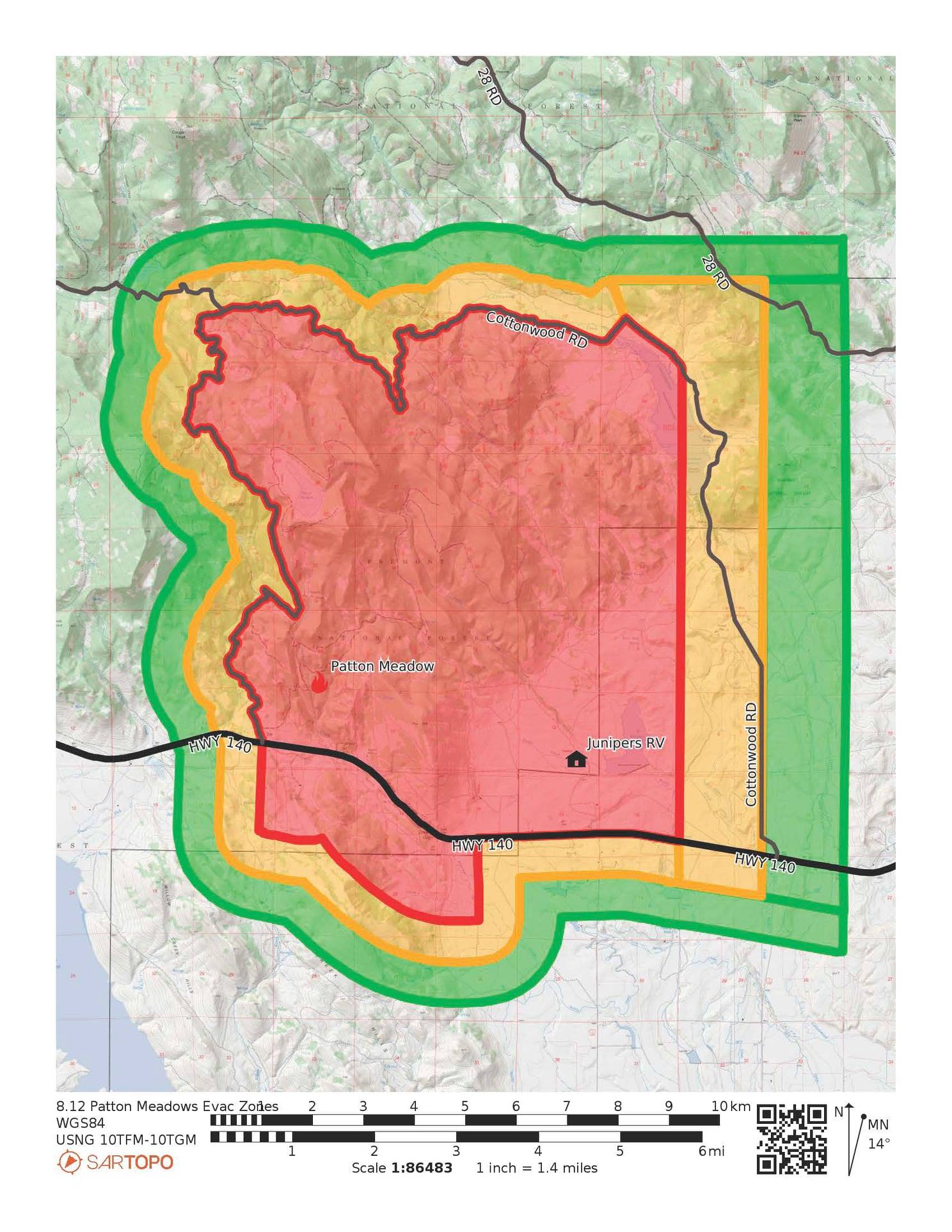
For the Patton Meadow Fire, the Lake County Sheriff’s Office of Emergency Management has identified areas for Level 3 (Go Now), Level 2 (Get Set) and Level 1 (Be Ready) in the fire area.
Lake County Evacuations
Level 3 Evacuation Notice (GO NOW – Residents should leave IMMEDIATELY.)
- Oregon State Highway 140 from Juniper RV Park to Antelope Valley Ranch.
- All of Drews Gap, on both sides of Oregon State Highway 140.
- West of Antelope Valley Ranch to Tracy Loop.
- North of Oregon State Highway 140 from Juniper RV Park to Lower Cottonwood Road.
- Tracy Loop to Upper Cottonwood Road
- East of Lower Cottonwood Road to Cottonwood Creek.
The emergency closure area for the Bootleg Fire on the Fremont-Winema National Forest includes all of the Patton Meadow Fire area and is especially important in the area for public and firefighter safety. The order is formally referenced as Closure Order Number 06-02-21-08.
Violations of the prohibitions are punishable by a fine of not more than $5,000 for an individual or $10,000 for an organization, or imprisonment for not more than 6 months, or both.
With ongoing extreme fire danger and fuel conditions, even a small spark can quickly grow to become a large wildfire. Everyone is asked to be careful with anything that could spark a wildfire and to report suspected wildfires immediately by calling 911.
###
South Central Oregon Fire Management Partnership provides comprehensive wildland fire services to more than eight million acres of land administered by the Bureau of Land Management Lakeview District; Fremont-Winema National Forest; Oregon Department of Forestry Klamath-Lake District; U.S. Fish and Wildlife Service’s Sheldon-Hart Mountain National Wildlife Refuge Complex; and Crater Lake National Park. The area encompasses federal, state, and private lands within south central Oregon and northwest Nevada.
FremontWinema National Forest Fire Area Emergency Closure 06022108
Related Incident:
Publication Type: Closures
FIRE AREA EMERGENCY CLOSUREFREMONT-WINEMA NATIONAL FOREST
Pursuant to 16 U.S.C. 551, 36 C.F.R. § 261.50(a) and (b), the following acts are prohibited on National Forest System lands and roads within the following described area on the Fremont-Winema National Forest, Bly, Chemult, Chiloquin, Lakeview, Paisley and Silver Lake Ranger Districts, as described in the attached Exhibit A. This Order becomes effective on August 5, 2021, and will remain in effect through December 31, 2021, or until rescinded.
This order supersedes and rescinds order #06-02-21-07 signed by Forest Supervisor Barry Imler on July 27, 2021.
PROHIBITIONS:
1. Going onto or being within an area closed for public health and safety. 36 CFR § 261.53 (e)
2. Being upon a closed road. 36 CFR § 261.54 (e)
The area described below will be closed to public access/entry due to hazards and hazardous conditions created as a result of the Bootleg Fire.
AFFECTED AREA/CLOSURE AREA:
All National Forest System lands south of Silver Lake Road between the Williamson River and Oregon State Highway 31. All National Forest System lands west of Oregon State Highway 31 and U.S. Highway 395 between Silver Lake Road and the junction with Oregon State Highway 140. All National Forest System lands north of Oregon State Highway 140 between U.S. Highway 395 and Sprague River Road. All National Forest System lands northeast of Sprague River Road from the junction with Oregon State Highway 140 to the Williamson River Road. All National Forest System lands east of Williamson River Road between Sprague River Road and the Williamson River. All National Forest System lands east of the Williamson River between Williamson River Road and Silver Lake Road. Refer to the attached map (Exhibit A).
EXEMPTIONS:
Pursuant to 36 CFR § 261.50(e), the following are exempt from this Order:
1. Persons with Forest Service Permit No. FS-7700-48 (Permit for Use of Roads, Trails, or Areas Restricted by Regulation or Order) specifically authorizing the otherwise prohibited act or omission.
2. Any Federal, State or Local Officer or member of an organized firefighting force in the performance of an official duty.
3. Owners or lessees of land in the affected area.
This prohibition is in addition to the general prohibitions in 36 C.F.R. Part 261, Subpart A.
Violations of this prohibition are punishable by a fine of not more than $5,000 for an individual or $10,000 for an organization, or imprisonment for not more than 6 months, or both (16 USC § 551; 18 USC §§ 3551, 3559, 3571, and 3581).
Done at Lakeview, Oregon, on _August 5, 2021_, at ________ AM / PM. ________________________________
BARRY L. IMLER Forest Supervisor Fremont-Winema National Forest
Actualization del los Incendios de Patton Meadow y Willow Valley13 Augusto
Related Incident:
Publication Type: News
PARA PUBLICACIÓN INMEDIATA
13 de agosto de 2021
Contacto de Media:
Tamara Schmidt
Celular: 541-891-6758
tamara.schmidt@usda.gov
Actualization del los Incendios de Patton Meadow y Willow Valley
LAKEVIEW, Ore. – Los incendios de Patton Meadow y Willow Valley continúan ardiendo en los condados de Klamath y Lake.
Se estima que el incendio de Patton Meadow tiene 7,000 acres sin contención. Los bomberos están trabajando para mantener el fuego al norte de la autopista 140 del estado de Oregón y al oeste de las estructuras a lo largo de Cottonwood Road.
El incendio está ardiendo aproximadamente a 10 millas al oeste de Lakeview en el condado de Lake en el distrito de Lakeview del Bosque Nacional Fremont-Winem, en tierras estatales y privadas protegidas por el Departamento de Silvicultura de Oregón (ODF).
Se estima que el incendio de Willow Valley tiene un área de 800 acres, incluidos 37 acres quemando en California, sin contención.
Actualmente, el incendio está quemando a 16 millas al sureste de Bonanza en el condado de Klamath, principalmente en las tierras del distrito de Lakeview del Buró de Administración de Tierras (BLM) al norte de Stateline, así como en parte del Bosque Nacional Modoc al sur. Las tierras protegidas de ODF están amenazadas.
Ambos incendios fueron provocados por un rayo ayer por la tarde. Los bomberos esperan un rápido crecimiento en ambos incendios hoy debido al clima pronosticado, las condiciones actuales del combustible y la falta de recursos.
La infraestructura de comunicación crítica está siendo amenazada en Grizzly Peak por el incendio de Patton Meadow.
Se espera que el Equipo 3 de ODF llegue al área el día de hoy para los incendios de Patton Meadow y Willow Valley. El Equipo Azul del Marshal de Bomberos del Estado de Oregón llegará hoy a Lakeview para el incendio de Patton Meadow. Está en efecto una orden de conflagración.
Para el incendio de Patton Meadow, la Oficina de Manejo de Emergencias del Sheriff del Condado de Lake ha identificado áreas para el Nivel 3 (¡Váyanse Ahora!), Nivel 2 (Estar Listo) y Nivel 1 (Prepárese) en el área del incendio.
Evacuaciones del condado de Lake
Aviso de evacuación de nivel 3 (¡Váyanse Ahora! - Los residentes deben irse INMEDIATAMENTE).
- Juniper RV Park hasta Patton Meadow.
- Todo Drews Gap, a ambos lados de la Carretera Estatal 140 de Oregón.
Nivel 2 (ESTAR LISTO - se insta a los residentes a estar preparados para irse INMEDIATAMENTE si es necesario).
- Al norte de la carretera estatal 140 de Oregón desde Juniper RV Park hasta Lower Cottonwood.
Nivel 1 (PREPÁRESE - los residentes deben hacer preparativos para una posible evacuación).
- Al Este de Lower Cottonwood Road y Cottonwood Creek.
La Cruz Roja ha establecido un centro de evacuación para el Incendio de Patton Meadow en la escuela secundaria Daly, ubicada en 220 South H St. en Lakeview.
No existen órdenes de evacuación para el incendio de Willow Valley. Sin embargo, los residentes en el área de la represa de Willow Valley deben estar monitoreando el incendio y preparados para evacuar si es necesario.
Hoy, hay una alerta roja a partir de las 2 p.m. a las 11 p.m. para rayos abundantes sobre combustibles secos.
Con el peligro de incendio extremo continuo y las condiciones de combustible, una pequeña chispa puede crecer rápidamente para convertirse en un gran incendio forestal. Se les pide a todos que tengan cuidado con cualquier cosa que pueda provocar un incendio forestal y que informen de inmediato los presuntos incendios forestales llamando al 911.
###
South Central Oregón Fire Management Partnership ofrece servicios integrales contra incendios forestales a más de ocho millones de acres de tierra administrados por el Buró de Administración de del Distrito de Lakeview; Bosque Nacional Fremont-Winema; Distrito de Klamath-Lake del Departamento de Silvicultura de Oregón; El Complejo del Refugio Nacional de Vida Silvestre Sheldon-Hart Mountain del Servicio de Pesca y Vida Silvestre de EE. UU. y el Parque Nacional Crater Lake. El área abarca tierras federales, estatales y privadas dentro del centro sur de Oregón y el noroeste de Nevada.
Patton Meadow and Willow Valley Fire08132021 AM
Related Incident:
Publication Type: News
For Immediate Release
August 13, 2021
Media Contact: Tamara Schmidt
541-891-6758
tamara.schmidt@usda.gov
Patton Meadow and Willow Valley Fire morning update
The Patton Meadow Fire is estimated to be 7,000 acres with no containment. Wildland firefighters are working to keep the fire north of Oregon State Highway 140 and west of the structures along Cottonwood Road.
The fire is burning approximately 10 miles west of Lakeview in Lake County on the Fremont-Winema National Forest Lakeview District and Oregon Department of Forestry (ODF) protected state and private lands.
The Willow Valley Fire is estimated to be 800 acres, including 37 acres burning in California, with no containment.
The fire is currently burning 16 miles southeast of Bonanza in Klamath County, mostly on Bureau of Land Management (BLM) Lakeview District lands north of the Stateline, as well as part of the Modoc National Forest to the south. ODF protected lands are threatened.
Both fires were caused by lightning yesterday afternoon. Firefighters are expecting rapid growth on both fires today due to forecasted weather, current fuel conditions and a lack of resources.
Critical communication infrastructure is being threatened on Grizzly Peak by the Patton Meadow Fire.
ODF Team 3 is expected to arrive in the area the area today for both the Patton Meadow and Willow Valley Fires. The Oregon State Fire Marshal Blue Team is arriving in Lakeview today for the Patton Meadow Fire. A conflagration order is in effect.
For the Patton Meadow Fire, the Lake County Sheriff’s Office of Emergency Management has identified areas for Level 3 (Go Now), Level 2 (Get Set) and Level 1 (Be Ready) in the fire area.
Lake County Evacuations
Level 3 Evacuation Notice (GO NOW – Residents should leave IMMEDIATELY.)
- Juniper RV Park to Patton Meadow.
- All of Drews Gap, on both sides of Oregon State Highway 140.
- North of Oregon State Highway 140 from Juniper RV Park to Lower Cottonwood.
- East of Lower Cottonwood Road and Cottonwood Creek.
There are no evacuation orders in place for the Willow Valley Fire. However, residents in the Willow Valley Reservoir area should be monitoring the fire and prepared to evacuate if necessary.
There is a Red Flag Warning in effect today from 2 p.m. to 11 p.m. for abundant lightning on dry fuels.
With ongoing extreme fire danger and fuel conditions, even a small spark can quickly grow to become a large wildfire. Everyone is asked to be careful with anything that could spark a wildfire and to report suspected wildfires immediately by calling 911.
###
South Central Oregon Fire Management Partnership provides comprehensive wildland fire services to more than eight million acres of land administered by the Bureau of Land Management Lakeview District; Fremont-Winema National Forest; Oregon Department of Forestry Klamath-Lake District; U.S. Fish and Wildlife Service’s Sheldon-Hart Mountain National Wildlife Refuge Complex; and Crater Lake National Park. The area encompasses federal, state, and private lands within south central Oregon and northwest Nevada.
Patton Meadow Fire Evacuations08122021 PM
Related Incident:
Publication Type: Announcement
For the Patton Meadow Fire, the Lake County Sheriff’s Office of Emergency Management has identified areas for Level 3 (Go Now), Level 2 (Get Set) and Level 1 (Be Ready) in the fire area.
Lake County Evacuations
Level 3 Evacuation Notice (GO NOW – Residents should leave IMMEDIATELY.)
• Juniper RV Park to Patton Meadow.
• All of Drews Gap, on both sides of Oregon State Highway 140.
Level 2 (GET SET – Residents are urged to be prepared to leave IMMEDIATELY if necessary.)
• North of Oregon State Highway 140 from Juniper RV Park to Lower Cottonwood.
Level 1 (GET READY – Residents should make preparations for potential evacuation.)
• East of Lower Cottonwood Road and Cottonwood Creek.
The Red Cross has been contacted to establish an evacuation center for the Patton Meadow Fire. Once one is established, the location will be shared.
There are no evacuation orders in place for the Willow Valley Fire. However, residents in the Willow Valley Reservoir area should be monitoring the fire and prepared to evacuate if necessary.
Lake CountyPatton Meadow Evacuations081220211645
Related Incident:
Publication Type: Announcement
Lake County Sheriff’s Office Media Release
August 12, 2021 4:45 p.m.
For Immediate Release
Contact: Melanie Lasley
(541) 947-6003mlasley@co.lake.or.us
Lakeview, OR – Evacuations. A new fire has started from a lightning strike west of Lakeview in the Antelope Canyon/Patton Meadow area. Effective immediately for residences North of Highway 140 and East of Patton Meadow Road:
Level 3 – GO NOW!
No Level 3 Evacuations at this time.
Level 2 – Be Set
No Level 2 Evacuations at this time.
Level 1 – Be Ready
Residences north of Highway 140 and East of Patton Meadow Road: A Level 1 evacuation is in effect from 140 West starting Antelope Canyon, west to Patton Meadow Road, and north of Patton Meadow Road to the Forest Service Boundary.
Further, the Fremont-Winema Forest remains closed; see updated closure orders on the Fremont-Winema website under ‘Alerts and Notices’.
Fire Information. Red Flag Warnings and Fire Weather Watches are in effect in parts of Lake County over the next several days. This means current fires may become more active and new fire starts may occur.
To sign up for Lake County’s Emergency Alerting System OR-Alert for future emergency notifications click the following link:https://member.everbridge.net/996436707639298/login?fbclid=IwAR0fpzmJvmdUMiS_UBnwIRoyea3uooQl59xebnoW7m7Cpifb6E60Tn3-sAM
Lake County Website/Facebook Page: https://www.lakecountyor.org/index.php and https://www.facebook.com/Lake-County-Oregon-104435824529906
Further, areas of the Fremont-Winema Forest remains closed; see updated closure orders on the Fremont-Winema website under ‘Alerts and Notices’.
Patton Meadow and Willow Valley Fire08122021 PM
Related Incident:
Publication Type: News
FOR IMMEDIATE RELEASE
August 12, 2021
Media Contact:Tamara Schmidt
Cell: 541-891-6758
tamara.schmidt@usda.gov
Lightning starts two new large fires in South Central Oregon today
LAKEVIEW, Ore. – This afternoon’s thunderstorm activity, including dry lightning, in Klamath and Lake counties resulted in two new large fires that the agencies of the South Central Oregon Fire Management Partnership (SCOFMP) are actively fighting.
The Patton Meadow Fire was reported just before 3:30 p.m. and was caused by lightning. The fire is estimated to be more than 2,000 acres. It is burning a mile and a half northwest of Booth State Scenic Corridor Park, approximately 14 miles west of Lakeview.
Fire behavior is running and torching in mixed conifer on remote, rugged steep terrain on the Fremont-Winema National Forest Lakeview Ranger District, as well as on Oregon Department of Forestry (ODF) protected private lands. The fire moved down the mountain tonight onto the valley floor west of Lakeview.
Willow Valley Fire was reported just before 4 p.m. and was caused by dry lightning. The fire is estimated to be 300 acres. It started on the Oregon side of the Oregon-California Stateline, approximately 1 mile east of Willow Valley Reservoir, 16 miles southeast of Bonanza.
The fire is currently burning mostly on Bureau of Land Management (BLM) Lakeview District lands north of the Stateline, as well as part of the Modoc National Forest to the south.
Fire behavior is running and spotting in juniper and sagebrush. SCOFMP resources, including a Type 3 Incident Commander are working on the fire with support from Modoc National Forest wildland firefighting resources.
Both the Patton Meadow and Willow Valley fires have numerous air and ground wildland firefighting resources fighting the fires, with more resources ordered.
For the Patton Meadow Fire, the Lake County Sheriff’s Office of Emergency Management has identified areas for Level 3 (Go Now), Level 2 (Get Set) and Level 1 (Be Ready) in the fire area.
Lake County Evacuations
Level 3 Evacuation Notice (GO NOW – Residents should leave IMMEDIATELY.)
- Juniper RV Park to Patton Meadow.
- All of Drews Gap, on both sides of Oregon State Highway 140.
Level 2 (GET SET – Residents are urged to be prepared to leave IMMEDIATELY if necessary.)
- North of Oregon State Highway 140 from Juniper RV Park to Lower Cottonwood.
Level 1 (GET READY – Residents should make preparations for potential evacuation.)
- East of Lower Cottonwood Road and Cottonwood Creek.
The Red Cross has been contacted to establish an evacuation center for the Patton Meadow Fire. Once one is established, the location will be shared.
There are no evacuation orders in place for the Willow Valley Fire. However, residents in the Willow Valley Reservoir area should be monitoring the fire and prepared to evacuate if necessary.
Thunderstorms this evening have impacted wildland firefighting efforts. There is a Red Flag Warning in effect tomorrow from 2 p.m. to 11 p.m.
Area residents and visitors are reminded that Public Use Restrictions are in effect throughout the SCOFMP area. Please visit www.scofmp.org to verify the restrictions for the landscape you plan to work or recreate on. Everyone is asked to be careful with anything that could spark a wildfire and to report suspected wildfires immediately by calling 911.
###
South Central Oregon Fire Management Partnership provides comprehensive wildland fire services to more than eight million acres of land administered by the Bureau of Land Management Lakeview District; Fremont-Winema National Forest; Oregon Department of Forestry Klamath-Lake District; U.S. Fish and Wildlife Service’s Sheldon-Hart Mountain National Wildlife Refuge Complex; and Crater Lake National Park. The area encompasses federal, state, and private lands within south central Oregon and northwest Nevada.
Pincer Creek Fire Update September 15 2021
Related Incident:
Publication Type: News
Pincer Creek Fire Update
Pincer Creek Fire Continues Smoldering and Creeping
Significant Rain Expected Later This Week
Everett, WA, Sept. 15, 2021 – Fire managers report that the Pincer Creek Fire has been relatively quiet over the last several weeks due to the cooler temperatures, increase in precipitation and a more fall like weather pattern. The fire continues to smolder and creep mostly within the Mineral Park Fire scar of 2003. The fire is estimated at 980 acres. Rolling debris and falling snags are a constant threat to the Cascade River Trail. It is anticipated that the Cascade River Trail (# 769) and Middle Fork Cascade River Trail (#769.1) will be closed until next spring at the earliest. It is hoped that over the winter fire weakened trees will fall, reducing the hazards on the trails.
Smoke: Air quality is currently good in the Puget Sound area. To learn more about changes in air quality in your region go to : wasmoke.blogspot.com/.
Inciweb: https://inciweb.nwcg.gov/incident/7797/
# # #
USDA is an equal opportunity provider, employer and lender.
Pincer Creek Fire Update August 23 2021
Related Incident:
Publication Type: News
Pincer Creek Fire Update
Contact: James Chu
Telephone: 971-334-7674
Date: August 23, 2021
Email address: 2021.pincercreek@firenet.gov
Pincer Creek Fire Continues to Burn
Warmer Weather Expected This Week
Everett, WA, Aug. 23, 2021 – Fire managers report that the Pincer Creek Fire was relatively quiet this weekend due to the cloudier and cooler weather. The fire received periodic drizzle through the weekend. The fire continues to burn more actively in areas where there are pockets of dead and down material from the 2003 fire and smolders in other areas. Fire activity increased after the cloud cover lifted on Saturday afternoon, but resumed the creeping behavior later in the weekend. The fire is approximately 865 acres and continues to burn within the Mineral Park Fire scar.
The Mt. Baker Ranger District Cascade River Trail, the Middle Fork Cascade Trail and South Fork Cascade Trail are closed to the public due to their proximity to the Pincer Creek Fire. The Sibley Creek Road and Hidden Lake Trail are not currently threatened by the fire, but are closed to allow firefighters to staff the lookout to support fire operations. This closure order is effective Aug 13, 2021 until rescinded: www.fs.usda.gov/alerts/mbs/alerts-notices.
Inciweb: https://inciweb.nwcg.gov/incident/7797/
# # #
USDA is an equal opportunity provider, employer and lender.
Pincer Creek Fire Update August 17 2021
Related Incident:
Publication Type: News
Mt Baker-Snoqualmie National Forest
Pincer Creek Fire
UpdateContact : James Chu
Telephone: 971-334-7674
Date: August 17, 2021
Email address: 2021.pincercreek@firenet.gov
Pincer Creek Fire Growth SlowsOlympic Wildland Fire Module Is Activated
Everett, WA, Aug. 17, 2021 – Fire managers report that the Pincer Creek Fire burned actively during the late afternoon and evening of August 15th after the smoke cover lifted. The fire resumed its more normal behavior on August 16th of burning actively on the east side of the fire, while smoldering on the west flank. The fire size is estimated to be approximately 840 acres. A few light showers are expected this morning, and additional light precipitation over the fire area is likely later this week. The outlook for next week is calling for a return to hot and dry weather near the end of the month.
Fire managers received additional support on Tuesday from the Olympic Interagency Wildland Fire Module, comprised of both Forest Service and National park Service employees. James “Britt” Davis, Forest Fire Staff Officer, offered his explanation the Forest’s request. “Our initial response was to utilize local engine crews to keep an eye on activity of our more active fires that are in areas too dangerous for firefighter deployment. While they have been very effective in their assignment, it’s a mission for which they were not designed. Engine crews are most effective actively responding to new fire starts and suppressing them or assisting other units with structure protection efforts. A Wildland Fire Module, on the other hand, is organized and equipped for exactly the Pincer Creek Fire assignment. They are the experts in assessing fire behavior and spread, taking actions to implement confinement strategies, and helping to develop plans for actions that will take place when the fire passes certain trigger points.”
Closures: Forest System Road #15 (Cascade River Road) from mile post 16.0 situated at the east boundary of Mineral Park Campground to mile post 18.1, situated at the boundary of North Cascades National Park. The closure is in place to manage recreation traffic east of Mineral Park in case the fire continues to grow. Fire managers predict that this fire closure will be in place until significant precipitation occurs over the fire area. They will continue to update their fire models to determine if changes can be made to the closure order. Mineral Park Campground remains open at this time and is not threatened by the fire.
The Mt. Baker Ranger District Cascade River Trail, the Middle Fork Cascade Trail and South Fork Cascade Trail are closed to the public due to their proximity to the Pincer Creek Fire. The Sibley Creek Road and Hidden Lake Trail are not currently threatened by the fire, but are closed to allow firefighters to staff the lookout to support fire operations. This closure order is effective Aug 13, 2021 until rescinded: www.fs.usda.gov/alerts/mbs/alerts-notices.
Smoke: Air quality has improved in the Puget Sound area due to the rain that arrived late last night. To learn more about changes in air quality in your region go to: wasmoke.blogspot.com/.
Fire Information Phone: 971-334-7674
Fire Information email address: 2021.pincercreek@firenet.gov
Inciweb: https://inciweb.nwcg.gov/incident/7797/
Facebook: www.facebook.com/MtBakerSnoqualmieNF
Twitter: twitter.com/MtBakerSnoNF
Hashtags: #PincerCreekFire #FireYear2021
# # # USDA is an equal opportunity provider, employer and lender.