
Greenwood Fire Fact Sheet September 26 2021
Related Incident:
Publication Type: News
GREENWOOD FIRE FACT SHEET - Sunday, September 26, 2021
Greenwood Fire information on InciWeb: https://inciweb.nwcg.gov/incident/7805/
Public Information Line: 218-499-9441 Email: 2021.greenwood@firenet.gov
Facebook Page: www.facebook.com/superiornationalforest
SIZE: 26,797 acres CONTAINMENT: 80% PERSONNEL: 120
WEATHER/FIRE BEHAVIOR: The weather today is expected to be partly cloudy. The high temperature will be 70 degrees and minimum humidity level of 45%. Winds will be 3 to 5 mph from the southwest and then switching to the northwest. Fire behavior is expected to be minimal.
The Greenwood Fire Fact Sheet will be updated every other day until further notice.
Greenwood Fire Fact Sheet September 24 2021
Related Incident:
Publication Type: News
GREENWOOD FIRE FACT SHEET - Friday, September 24, 2021
Greenwood Fire information on InciWeb: https://inciweb.nwcg.gov/incident/7805/
Public Information Line: 218-499-9441 Email: 2021.greenwood@firenet.gov
Facebook Page: www.facebook.com/superiornationalforest
SIZE: 26,797 acres CONTAINMENT: 80% PERSONNEL: 125
WEATHER/FIRE BEHAVIOR: The weather today is expected to be cloudy with rain showers. The high temperature will be 59 degrees and minimum humidity level of 49%. Winds will be from the west/northwest at 6 to 9 mph with gusts up to 20 mph. Fire behavior is expected to be minimal.
The Greenwood Fire Fact Sheet will be updated every other day until further notice.
Greenwood Fire Update September 22 2021
Related Incident:
Publication Type: News
ANNOUNCEMENT: As work on the fire winds down, we will begin sending out updates less frequently. The next update you will receive will be on Friday, September 24, and every other day from then on until further notice.
WEATHER/FIRE BEHAVIOR: Today will be partly sunny with a 20 percent chance of showers. The high today will be around 59 degrees and relative humidity around 57 percent. Northwest winds around 7 mph with gusts to around 14 mph. Expect another wind shift to occur around 5 PM, with winds backing to the south. Fire behavior concerns for today are low over most of the state with the exception of the far northwest corner.
· Open areas: forest lands and roads north of Highway 1 including Boundary Waters Canoe Area Wilderness Entry points - Island River, Isabella Lake, Bog Lake, Little Isabella River, Snake River, Hog Creek, and Pow Wow Trail.
· Closed areas: forest lands and roads south of Highway 1 including the Sand Lake Recreation Area and rustic campground, McDougal Lake area and all associated recreation areas and the Stony River Observation Point. Little Isabella Campground will also remain closed due to bear issues and rehabilitation.
Greenwood Fire Update September 21 2021
Related Incident:
Publication Type: News
· Open areas: forest lands and roads north of Highway 1 including Boundary Waters Canoe Area Wilderness Entry points - Island River, Isabella Lake, Bog Lake, Little Isabella River, Snake River, Hog Creek, and Pow Wow Trail.
· Closed areas: forest lands and roads south of Highway 1 including the McDougal Lake area and all associated recreation areas and the Stony River Observation Point. Little Isabella Campground will also remain closed due to bear issues and rehabilitation.
WEATHER/FIRE BEHAVIOR: Drier conditions are expected today, along with relatively lighter winds compared to the last few days. Winds will remain from the northwest throughout the day, sustained 5 to 10 mph and gusts up to 20 mph. Today will be partly sunny with a high of 59. Relative humidity will be around 56 percent.
Greenwood Fire Update September 20 2021
Related Incident:
Publication Type: News
GREENWOOD FIRE QUICK FACTS
WEATHER/FIRE BEHAVIOR: Gusty conditions continue today as a low pressure system moves through the area. Southerly flow will switch to northwesterly as a cold front moves through in the late afternoon. A line of showers and thunderstorms is expected to reach the fire in the late morning and early afternoon ahead of this front, with strong winds as the main concern. Occasional wind gusts 50-60 mph could be possible with this line. Today will be mostly cloudy with nearly a 100 percent chance of showers and thunderstorms in the afternoon. High temperatures will reach 73 and the humidity will be a minimum of 78 percent. South winds 9 to 13 mph shifting to the southwest 8 to 9 mph late in the afternoon with gusts to 27 mph.
Daily Fire Update September 19 2021
Related Incident:
Publication Type: News
WEATHER/FIRE BEHAVIOR: A strong pressure gradient will continue to strengthen over the area as high pressure moves eastward. Gusty south winds are expected to build on Sunday, from 7-13 mph increasing to 11-17 mph. Stronger southerly winds are expected to gust up to 25-35 mph and locally higher gusts are possible. Sunday will be mostly sunny, and temperatures will become very warm with afternoon highs reaching into the mid-80s across the region. Relative humidity will be from 40-55%.
Greenwood Fire update September 18 2021
Related Incident:
Publication Type: News
GREENWOOD FIRE QUICK FACTS SIZE: 26,797 acres CONTAINMENT: 80% PERSONNEL: 196
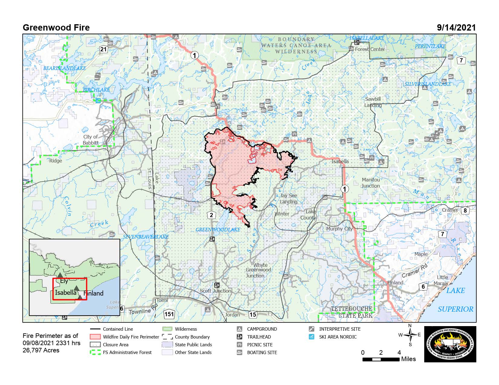
SUMMARY: Started by lightning, the Greenwood Fire was detected on August 15, 2021, about 3:00 p.m. on the Laurentian Ranger District. The fire started approximately ten miles southwest of Isabella. 14 primary structures and 57 outbuildings were destroyed on August 23. The objective of fire management for the Greenwood Fire is full suppression using all available resources.
YESTERDAY: Firefighting crews continued their job of rehabilitating the impacts of fire-fighting., Heavy equipment, including a feller buncher, was used to conduct extensive hazard tree mitigation along Highway 2. A feller buncher cuts and gathers trees, and consists of a standard heavy equipment base with a tree-grabbing device with a chain-saw, circular saw, or shear—a pinching device designed to cut small trees off at the base. The machine then places the cut tree on a stack.
TODAY: Crews will continue to rehabilitate containment lines. This is done by pulling cleared vegetation back onto the dozer line to create a vegetation layer that protects the soil and reduces the chances of the dozer line being used as a trail. The goal of rehabilitation is to return the area to its normal state as much as possible. A type 3 helicopter and heat-detecting infra-red flights will be used to monitor the fire.
WEATHER/FIRE BEHAVIOR: Saturday is predicted to be sunny, with patchy frost until 9 a.m. High temperatures will reach 73 degrees on Saturday. Relative humidity will drop into the 30 to 40 percent range. Winds are from the south from 3-11 mph, increasing to 8-13 mph in the afternoon with gusts up to 21 mph. Fire behavior concerns for Saturday remain minimal. Saturday will be the second day of recovery in fine fuels, and with the given weather conditions, areas with fine fuels exposed to the sun in the Arrowhead could see some fire activity.
SAFETY & EVACUATIONS: The Lake County Sheriff’s Office has opened Highway 2 between Highway 11 and Highway 1 to all traffic. Be alert for firefighters and fire equipment in the area and observe posted speed limits. For information about getting a checkpoint pass to access your property on Highway 1, call Lake County Dispatch, 218-510-0640.
Evacuation orders remain in place for the McDougal Lake area.
CLOSURES:
- Highway 1 is closed from the Highway 1 and Highway 2 intersection to Lankinen Road and only property owners with passes issued by the Sheriff’s Office may travel along the highway. Highway 2 is open to all traffic.
- National Forest System lands, roads and recreation areas are closed in the area of the Greenwood Fire to protect public health and safety. The closure area extends across the Kawishiwi, Laurentian, and Tofte Ranger Districts and includes several Boundary Waters Canoe Area Wilderness Entry Points. To see the full Forest order and other Forest closures, visit https://www.fs.usda.gov/superior.
Greenwood Fire Update September 17 2021
Related Incident:
Publication Type: News
GREENWOOD FIRE QUICK FACTS SIZE: 26,797 acres CONTAINMENT: 80% PERSONNEL: 196
ANNOUCEMENT: Superior National Forest is lifting fire restrictions across National Forest System lands, including the Boundary Waters Canoe Area Wilderness management area. Although campfires, charcoal grills and stoves are allowed, please practice caution by keeping fires small, not tall and ensuring your fire is out cold to the touch before leaving it unattended. Drown, stir, touch and repeat until the fire is completely extinguished. Some fire restrictions remain place for state and private lands, check MN DNR Wildland Fire Information for details.
SUMMARY: Started by lightning, the Greenwood Fire was detected on August 15, 2021, about 3:00 p.m. on the Laurentian Ranger District. The fire started approximately ten miles southwest of Isabella. 14 primary structures and 57 outbuildings were destroyed on August 23. The objective of fire management for the Greenwood Fire is full suppression using all available resources.
YESTERDAY: Road rehabilitation continued with grading to return to appropriate road standards. Crews patrolled areas along Highway 2 and found little heat in that division. In contrast, firefighters cooled areas of smoldering heat found around tree roots on the eastern edge of the fire. Crews removed merchantable wood along Highway 2 in order to fully utilize it. Work continued to remove snags and hazard trees around McDougal Lake the objective is to reduce the number of hazardous, fire-damaged trees in this area so landowners can return.
TODAY: Fire crews will watch for hazard trees along Highways 1 and 2 and remove; high winds and rain can make fire-killed trees even more hazardous as roots lose their hold on the soil. Crews continue to repair control line by pulling berms of topsoil along the sides of the control line back onto the line. Firefighters will be removing hose from the fire perimeter where heat has been eliminated. A heat-detecting, infra-red flight is scheduled for today, weather permitting.
WEATHER/FIRE BEHAVIOR: Today will be mostly sunny with high temperatures in the low 60s. Relative humidity will be between 35-47 %. Wind is from the west from 4-9 mph, increasing to 6-15 mph in the late morning and afternoon with gusts up to 24 mph. No rainfall is expected this weekend as high pressure moves across the area. Looking ahead, a prolonged wet period may be possible for the early half of next week.
SAFETY & EVACUATIONS: The Lake County Sheriff’s Office has opened Highway 2 between Highway 11 and Highway 1 to all traffic. Be alert for firefighters and fire equipment in the area and observe posted speed limits. For information about getting a checkpoint pass to access your property on Highway 1, call Lake County Dispatch, 218-510-0640.
Evacuation orders remain in place for the McDougal Lake area.
CLOSURES:
- Highway 1 is closed from the Highway 1 and Highway 2 intersection to Lankinen Road and only property owners with passes issued by the Sheriff’s Office may travel along the highway. Highway 2 is open to all traffic.
- National Forest System lands, roads and recreation areas are closed in the area of the Greenwood Fire to protect public health and safety. The closure area extends across the Kawishiwi, Laurentian, and Tofte Ranger Districts and includes several Boundary Waters Canoe Area Wilderness Entry Points. To see the full Forest order and other Forest closures, visit https://www.fs.usda.gov/superior.
FIRE RESTRICTIONS: Fire restrictions are being evaluated daily and are currently in place for the Superior National Forest and Minnesota Department of Natural Resources for areas within state jurisdiction, Cook and Lake Counties, and northern St. Louis County. See the Superior National Forest Fire Restrictions Order and the Minnesota Department of Natural Resources MN DNR Wildland Fire Information for more information.
Greenwood Fire Update Sepetember 16 2021
Related Incident:
Publication Type: News
GREENWOOD FIRE QUICK FACTS SIZE: 26,797 acres CONTAINMENT: 75% PERSONNEL: 217
SUMMARY: Started by lightning, the Greenwood Fire was detected on August 15, 2021, about 3:00 p.m. on the Laurentian Ranger District. The fire started approximately ten miles southwest of Isabella. 14 primary structures and 57 outbuildings were destroyed on August 23. The objective of fire management for the Greenwood Fire is full suppression using all available resources.
YESTERDAY: The heavy equipment group continued to remove and chip hazard trees along Highway 1. Merchantable wood is being sorted from non-merchantable material in order to fully utilize it. Crews patrolled areas of deep heat along the Highway 2 corridor and found some areas with no heat. Crews using heavy equipment continued their work to remove snags and hazard trees around McDougal Lake the objective of the fire crews is to reduce the number of hazardous, fire-damaged trees in this area to make it safe for people to return.
TODAY: Fire crews continue to search for and cool hot spots along the fire perimeter in numerous locations. Firefighters will rehabilitate areas of fire line construction. Patrolling for hot spots continues, and crews will begin working to reduce hazards into the interior of the fire perimeter.
WEATHER/FIRE BEHAVIOR: The next storm system will move through the Arrowhead Region with showers and thunderstorms likely Thursday into Friday. Some storms may be strong to severe Thursday afternoon with gusty winds, hail, and dangerous lightning possible. Rainfall totals are expected to be a half to one inch and possibly locally heavier amounts into Friday. Fire behavior concerns for Thursday are minimal, but warmer weather over the weekend will dry vegetation, making it available as fuel for fire.
SAFETY & EVACUATIONS: The Lake County Sheriff’s Office has opened Highway 2 between Highway 11 and Highway 1 to all traffic. Be alert for firefighters and fire equipment in the area and observe posted speed limits. For information about getting a checkpoint pass to access your property on Highway 1, call Lake County Dispatch, 218-510-0640.
Evacuation orders remain in place for the McDougal Lake area.
CLOSURES:
Highway 1 is closed from the Highway 1 and Highway 2 intersection to Lankinen Road and only property owners with passes issued by the Sheriff’s Office may travel along the highway. Highway 2 is open to all traffic.
National Forest System lands, roads and recreation areas are closed in the area of the Greenwood Fire to protect public health and safety. The closure area extends across the Kawishiwi, Laurentian, and Tofte Ranger Districts and includes several Boundary Waters Canoe Area Wilderness Entry Points. To see the full Forest order and other Forest closures, visit https://www.fs.usda.gov/superior.
FIRE RESTRICTIONS: Fire restrictions are being evaluated daily and are currently in place for the Superior National Forest and Minnesota Department of Natural Resources for areas within state jurisdiction, Cook and Lake Counties, and northern St. Louis County. See the Superior National Forest Fire Restrictions Order and the Minnesota Department of Natural Resources MN DNR Wildland Fire Information for more information.
Greenwood Fire Update September 15 2021
Related Incident:
Publication Type: News
GREENWOOD FIRE QUICK FACTS SIZE: 26,797 acres CONTAINMENT: 75% PERSONNEL: 217
SUMMARY: Started by lightning, the Greenwood Fire was detected on August 15, 2021, about 3:00 p.m. on the Laurentian Ranger District. The fire started approximately ten miles southwest of Isabella. 14 primary structures and 57 outbuildings were destroyed on August 23. The objective of fire management for the Greenwood Fire is full suppression using all available resources.
YESTERDAY: The heavy equipment group continued to mitigate hazard trees along Highway 2. Merchantable wood is being sorted from non-merchantable material in order to fully utilize it. Crews patrolled and cooled areas of deep heat along the Highway 2 corridor. On the fire’s edge southeast of Greenwood Lake, the Wildland Fire Module continued to work to find and extinguish hot spots. Firefighters assessed heat in the dozer berms and cooled areas nearby. Crews using heavy equipment continued their work around McDougal Lake. The objective of the fire crews is to reduce the number of hazardous, fire-damaged trees in this area.
TODAY: Firefighters continue to search for and cool hot spots along the fire perimeter in numerous locations. Fire crews are cleaning up along Highway 1 where the fuel break had been constructed. Road graders are being used to repair roads where necessary and safe.
WEATHER/FIRE BEHAVIOR: High pressure will quickly move through the Great Lakes Region today with a brief warming trend, lower relative humidity, and westerly winds. Tomorrow will be mostly cloudy with a 70% chance of showers and thunderstorms. Highs will be in the high 60s with relative humidity between 55-60%. The wind will be from the southwest at about 10 mph with gusts up to around 20 mph. While there have been a few soaking rains in the area, northeastern Minnesota still falls short of normal annual precipitation. Warmer weather will continue to dry vegetation, making it available as fuel for fire. Fire behavior concerns for Wednesday are minimal. Lower RH, winds, and sunny skies may combine to produce increased activity in hotspots but fire spread is not anticipated.
SAFETY & EVACUATIONS: The Lake County Sheriff’s Office has opened Highway 2 between Highway 11 and Highway 1 to all traffic. Be alert for firefighters and fire equipment in the area and observe posted speed limits. For information about getting a checkpoint pass to access your property on Highway 1, call Lake County Dispatch, 218-510-0640.
Evacuation orders remain in place for the McDougal Lake area.
CLOSURES:
Highway 1 is closed from the Highway 1 and Highway 2 intersection to Lankinen Road and only property owners with passes issued by the Sheriff’s Office may travel along the highway. Highway 2 is open to all traffic.
National Forest System lands, roads and recreation areas are closed in the area of the Greenwood Fire to protect public health and safety. The closure area extends across the Kawishiwi, Laurentian, and Tofte Ranger Districts and includes several Boundary Waters Canoe Area Wilderness Entry Points. To see the full Forest order and other Forest closures, visit https://www.fs.usda.gov/superior.
FIRE RESTRICTIONS: Fire restrictions are being evaluated daily and are currently in place for the Superior National Forest and Minnesota Department of Natural Resources for areas within state jurisdiction, Cook and Lake Counties, and northern St. Louis County. See the Superior National Forest Fire Restrictions Order and the Minnesota Department of Natural Resources MN DNR Wildland Fire Information for more information.