
John Ek Whelp Fact Sheet for 8252021
Related Incident:
Publication Type: News
A public meeting will be held tonight at 6 pm at the Tofte Town Hall: 7240 Tofte Park Rd, Tofte, MN.
A recording of the meeting will be posted to Superior NF Facebook this evening.
Overview: Yesterday showed minimal to moderate fire activity on both fires. No firefighters have been sent directly to the fires due to difficult access, limited aircraft resources, and safety concerns. Local fire department staff and an infrastructure group of two crews from Alaska and Indiana will be working along the Gunflint Trail to conduct firewise activities as able. The MNICS Team plans to insert ground resources on Whelp Fire within two days once communications and air support are in place.
John Ek Fire: The fire is 2.5 miles south of Little Saganaga Lake and extends from John Ek Lake to the SE corner of Elton Lake. The John Ek Fire is estimated to be 1563 acres in size. A reconnaissance flight is scheduled for this morning and afternoon to continue to develop suppression plans. Water drops will be performed as necessary if the fire becomes active. There are no mandatory evacuations in Cook County at this time. Homeowners in Cook County can sign up for the emergency alert system CodeRED at https://www.co.cook.mn.us/index.php/2016-04-14-15-58-03. The Cook County Sheriff’s Office recommends that residents and visitors be in “ready” mode in case of eventual evacuation.
Whelp Fire: The Whelp Fire is a lightning-caused fire located five miles northwest of Sawbill Lake and is an estimated 50 acres. Fire continues to show moderate fire behavior with backing, creeping, and some torching. A helitack crew will inspect and improve the helispot today to prepare for the insertion of firefighters.
Closure Update: The Forest is closing National Forest lands and roads along the upper portion of the Gunflint Trail. County roads and private roads remain open. The closure includes all forest lands and roads along Cook County 12/Gunflint Trail beginning at the Cook County 92 intersection to the end of the Gunflint Trail. This closure area includes Trails End and Iron Lake campgrounds. Campground reservations have been cancelled and refunded for the next seven days, through August 31. This closure is consistent with the Cook County Sheriff’s pre-evacuation area for the upper Gunflint Trail area due to the John Ek Fire. The closure includes all lands, waters, trails, portages, campsite, canoe routes, and Wilderness entry points in the Boundary Waters Canoe Area Wilderness. The Forest has notified permit holders and outfitters and is cancelling permits August 21 through September 3. For details on closure areas, visit the Superior National Forest webpage. With continued fires and a shortage of firefighting resources, these closures allow firefighters to focus on existing fires or new starts without the concern for public safety.
Fire Restrictions: The Superior National Forest is not allowing campfires within the Forest boundary on National Forest lands, including the BWCAW. Propane devices with an on/off switch are permitted, including lanterns, stoves, and fire pits. Please see Fire Restrictions Order and our Campfire Restrictions FAQ for more information.
The Minnesota Department of Natural Resources has various fire restrictions throughout the state. The burning restrictions reflect on-the-ground conditions and wildland fire response capacity, assessed on a county-by-county basis. Please see their website for additional details: https://www.dnr.state.mn.us/forestry/fire/index.html
John Ek Whelp Fire Fact Sheet for 8242021
Related Incident:
Publication Type: News
A public meeting will be held on August 25 at 6 pm at the Tofte Town Hall: 7240 Tofte Park Rd, Tofte, MN
Overview: The Superior National Forest continues to sweep visitors from the Wilderness in a safe and orderly manner. Yesterday there was high activity on the two fires due to sustained, gusty, erratic winds. No fire-fighting crews have been sent directly to the fires due to difficult access, limited aircraft resources, and safety concerns.
John Ek Fire: The fire is 2.5 miles south of Little Saganaga Lake and extends from John Ek Lake to the SE corner of Elton Lake. The John Ek Fire stayed in place at 800 acres yesterday morning, but extreme fire weather behavior contributed to the fire doubling in size to about 1,500 acres later in the afternoon. A reconnaissance flight is scheduled for this morning to develop suppression plans for both John Ek and Whelp Fires.
There are no mandatory evacuations in Cook County as of yesterday. Homeowners in Cook County can sign up for the emergency alert system CodeRED at https://www.co.cook.mn.us/index.php/2016-04-14-15-58-03. The Cook County Sheriff’s Office recommends that residents and visitors be in “ready” mode in case of eventual evacuation. Residents can gather pets and belongings together to be prepared to leave if the order comes. If there is an evacuation, the sheriff’s office will go door-to-door to inform residents and visitors this is happening. Meanwhile, remain calm and be ready.
Whelp Fire: The Whelp Fire is a lightning-caused fire located five miles northwest of Sawbill Lake and is an estimated 60 acres. Fire growth was a result of yesterday’s sustained winds. Aircraft conducted water drops on the fire yesterday.
Closure Update: A closure is in place for the entire Boundary Waters Canoe Area Wilderness, effective August 21, 2021, due to active and increasing fire activity, extreme drought, and limited resources. The closure includes all lands, waters, trails, portages, campsite, canoe routes, and Wilderness entry points in the Boundary Waters Canoe Area Wilderness. The Forest has notified permit holders and outfitters and is cancelling permits August 21 through August 27. Permit holders will be fully reimbursed. At this time, all overnight paddle, day use and motorized day use is cancelled. The Forest will reopen portions of the Wilderness and some uses when it is safe. For details on closure areas, visit the Superior National Forest webpage. With continued fires and a shortage of firefighting resources, these closures allow firefighters to focus on existing fires or new starts without the concern of public safety.
Fire Restrictions: Due to continued long-term drought conditions and limited fire-fighting resources, the Superior National Forest is not allowing campfires within the Forest boundary on National Forest lands, including the BWCAW. Propane devices with an on/off switch are permitted, including lanterns, stoves, and fire pits. Please see Fire Restrictions Order and our Campfire Restrictions FAQ for more information.
The Minnesota Department of Natural Resources has various fire restrictions throughout the state. The burning restrictions reflect on-the-ground conditions and wildland fire response capacity, assessed on a county-by-county basis. Please see their website for additional details: https://www.dnr.state.mn.us/forestry/fire/index.html
PreEvacuation Status along Gunflint Trail
Related Incident:
Publication Type: Announcement
Residents of the Gunflint Trail located from end of the trail to the South end of Loon Lake will be notified tonight of PRE-EVACUATION status by fire department and local sheriffs.
This is NO evacuation at this time.
- Turn on sprinklers
- Pack medications
-Gather pets-
-Pack up valuables
If you choose to pre-evacuate, please stop in at the YMCA in Grand Marais and check in with law enforcement.
Facebook Video Link: https://fb.watch/7zZ52cpR6I/
John Ek Whelp Fire Fact Sheet for 8232021
Related Incident:
Publication Type: News
Overview: The Superior National Forest continues to sweep visitors from the Wilderness in a safe and orderly manner. The MNCIS Type 3 team assumed command of the fires beginning today. No fire-fighting crews have been sent directly to the fires due to difficult access, limited aircraft resources, and safety concerns. Crews will focus on fuels mitigation projects in the Sawbill Lake area today. A reconnaissance flight is scheduled for this morning to assess both John Ek and Whelp Fires. To view the public meeting held on August 22, please go to https://fb.watch/7zvsmQ4zlW/.
John Ek Fire: The John Ek fire held its current footprint yesterday of an estimated 800 acres with cooler air temperatures over the area. The fire is 2.5 miles south of Little Saganaga Lake and extends from John Ek Lake to the SE corner of Elton Lake.
Whelp Fire: The Whelp Fire is a lightning-caused fire located five miles northwest of Sawbill Lake, and continues to creep and smolder in the deep duff without moving outside of its current footprint of an estimated 50 acres.
Closure Update: A closure is in place for the entire Boundary Waters Canoe Area Wilderness, effective August 21, 2021, due to active and increasing fire activity, extreme drought, and limited resources. The closure includes all lands, waters, trails, portages, campsite, canoe routes, and Wilderness entry points in the Boundary Waters Canoe Area Wilderness. The Forest has notified permit holders and outfitters and is cancelling permits August 21 through August 27. Permit holders will be fully reimbursed. At this time, all overnight paddle, day use and motorized day use is cancelled. The Forest will reopen portions of the Wilderness and some uses when it is safe.
For details on closure areas, visit the Superior National Forest webpage. With continued fires and a shortage of firefighting resources, these closures allow firefighters to focus on existing fires or new starts without worrying about public safety.
Evacuations: There are no mandatory evacuations in Cook County as of noon today. Homeowners in Cook County can sign up for the emergency alert system CodeRED at https://www.co.cook.mn.us/index.php/2016-04-14-15-58-03.
Fire Restrictions: Due to continued long-term drought conditions and limited fire-fighting resources, the Superior National Forest is not allowing campfires within the Forest boundary on National Forest lands, including the BWCAW. Propane devices with an on/off switch are permitted, including lanterns, stoves, and firepits. Please see Fire Restrictions Order and our Campfire Restrictions FAQ for more information.
The Minnesota Department of Natural Resources has various fire restrictions throughout the state. The burning restrictions reflect on-the-ground conditions and wildland fire response capacity, assessed on a county-by-county basis. Please see their website for additional details: https://www.dnr.state.mn.us/forestry/fire/index.htmlJohn Ek Whelp Fire Fact Sheet for 8222021
Related Incident:
Publication Type: News
Public Meeting: Today we will be having a public meeting for the John Ek and Whelp Fires at the Schaap Community Center on the Gunflint Trail at 6 pm. The meeting will be held outside to follow COVID guidelines.
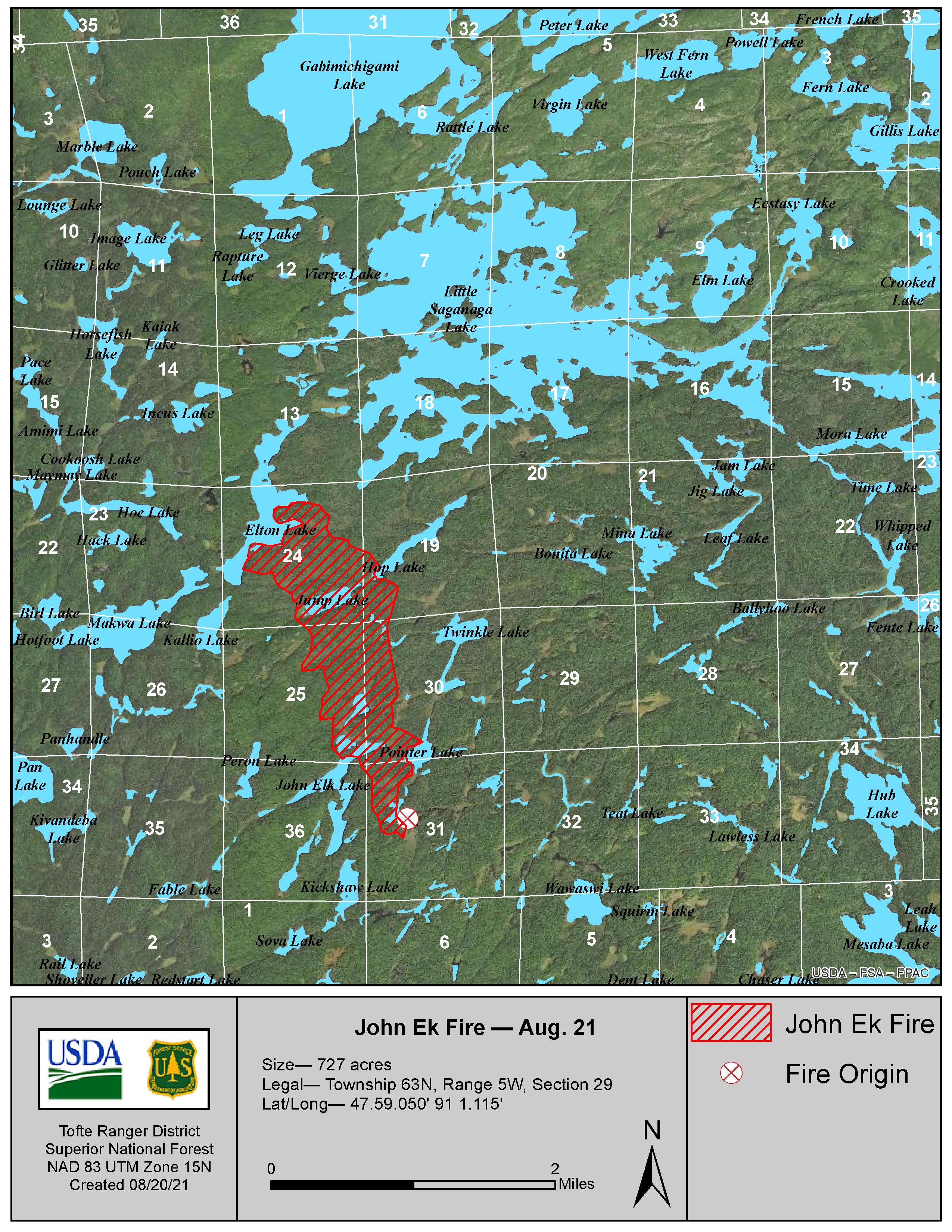
John Ek Fire: The John Ek Fire was successfully kept in its current footprint yesterday with cooler temperatures and suppression activities by aircraft. The fire is estimated at 727 acres due to more accurate mapping from aerial flights. The fire is located 2.5 miles south of Little Saganaga Lake and extends from John Ek Lake to the SE corner of Elton Lake. Beaver float planes flew the Wilderness to identify campers and notify them of the current closure. Today crews and float planes will be used to sweep the area of visitors. Ground suppression activities are still not possible due to difficult access and firefighter safety concerns. Fire-suppressing aircraft continue to drop water on the fire to try to limit its spread. A MNICS Type 3 team will assume command of the fires beginning on Monday, August 23.
Whelp Fire: This fire continues to creep and smolder in the duff without moving outside of its current footprint of 50 acres. The Whelp Fire is a lightning-caused fire located five miles west of Sawbill Lake.
A helitack crew will begin improving a nearby helispot today to improve access. No firefighting crews have been sent in due to difficult access, limited aircraft resources, and safety concerns. Fire-suppressing aircraft continue to drop water on this fire to try and limit its spread.
Closure Update: A closure is in place for the entire Boundary Waters Canoe Area Wilderness, effective August 21, 2021, due to active and increasing fire activity, extreme drought, and limited resources. The closure includes all lands, waters, trails, portages, campsites, canoe routes, and entry points in the Boundary Waters Canoe Area Wilderness. The Forest has notified permit holders and outfitters and is cancelling permits today through August 27. Permit holders will be fully reimbursed. At this time, all overnight paddle, day use, and motorized day use is cancelled. The Forest will reopen portions of the Wilderness and/or some uses when it is safe. For details on closure areas, visit the Superior National Forest webpage. With continued fires and a shortage of firefighting resources, these closures allow firefighters to focus on existing fires or new starts without worrying about public safety.
Evacuations: There are no mandatory evacuations in Cook County as of noon today. Homeowners in Cook County should sign up for the emergency alert system CodeRED at https://www.co.cook.mn.us/index.php/2016-04-14-15-58-03.
Fire Restrictions: The Superior National Forest is not allowing campfires within the Forest boundary on National Forest lands, including the BWCAW. Propane devices with an on/off switch are permitted, including lanterns, stoves, and firepits. Please see Fire Restrictions Order and our Campfire Restrictions FAQ for more information. The Minnesota Department of Natural Resources has various fire restrictions throughout the state. The burning restrictions reflect on-the-ground conditions and wildland fire response capacity as assessed on a county-by-county basis. Please see their website for additional details: https://www.dnr.state.mn.us/forestry/fire/index.html
East Zone Fire Fact Sheet 8212021
Related Incident:
Publication Type: News
Superior National Forest Fire Information: Please call the fire information number at 218-214-7844 or visit online at: https://inciweb.nwcg.gov/, the Superior NF website: www.fs.usda.gov/superior or the forest’s Facebook page: https://www.facebook.com/SuperiorNF/ . For Greenwood Fire Information, please call 218-499-9441.
Closure Update: The Superior National Forest is closing the Boundary Waters Canoe Area Wilderness, effective August 21, 2021, due to active and increasing fire activity, extreme drought, limited resources. The closure will be in place for seven days, and may be modified or extended as conditions allow.
For details on closure areas, visit the Superior National Forest webpage. With continued fires and a shortage of firefighting resources, these closures allow firefighters to focus on existing fires or new starts without worrying about public safety.
East Zone Fires:
John Elk Fire: The John Elk Fire left its three-acre footprint and grew rapidly yesterday after another day of hot, dry weather and gusty winds. Saturday’s reconnaissance flight reports the size at 1500 acres in a narrow cigar shape from John Elk to the SE corner of Elton in the BWCA Wilderness. Ground suppression activities are still not possible due to the difficult access and firefighter safety concerns. Fire-suppressing aircraft continue to drop water on these fires to try and limit their spread. Yesterday wilderness ranger crews and a beaver floatplane made contact with visitors on several lakes, including Little Sag Lake, Mora Lake and Crooked Lake. More wilderness ranger crews, and floatplanes will be used today to notify campers and sweep the area of visitors.
Whelp Fire: The Whelp fire, four miles NW of Sawbill Lake, also expanded in size yesterday to 50 acres. This fire is creeping and smoldering. No fire-fighting crews have been sent in due to difficult access, limited aircraft resources, and safety concerns. Fire-suppressing aircraft continue to drop water on this fire to try and limit its spread. More wilderness ranger crews and beaver floatplanes will be used today to notify campers and sweep the area of visitors.
Canada Fires: Quetico Provincial Park is managing several fires burning across the international border from the BWCAW. Three of those fires have potential to spread into the US near Crooked and Iron lakes. Fire activity has been very active in Canada this week due to dry weather and breezy winds. Fire growth has been mainly towards the north due to south winds. The Forest is conducting daily monitoring flights over the fires and coordinating with counterparts in Ontario. For more information on the fires in Ontario and for an interactive fire map visit: https://www.ontario.ca/page/forest-fires.
Air Quality: The Minnesota Pollution Control Agency (MPCA) has issued an air quality alert effective until 3 p.m. on Monday, Aug. 23, for Lake and Cook Counties. The affected area includes Isabella, Silver Bay, Grand Marais, and the tribal nation of Grand Portage. For more information on current air quality conditions in your area and to sign up for daily air quality forecasts visit MPCA’s Air Quality Index webpage.
Fire Restrictions: Due to continued long-term drought conditions and limited fire-fighting resources, the Superior National Forest is not allowing campfires within the Forest boundary on National Forest lands, including the BWCAW. Propane devices with an on/off switch are permitted, including lanterns, stoves, and firepits. Please see Fire Restrictions Order and our Campfire Restrictions FAQ for more information.
The MN Department of Natural Resources has various fire restrictions throughout the state. The burning restrictions reflect on-the-ground conditions and wildland fire response capacity as assessed on a county-by-county basis. Please see their website for additional details: https://www.dnr.state.mn.us/forestry/fire/index.html
East Zone Fire Fact Sheet for 8202021
Related Incident:
Publication Type: News
Superior National Forest Fire Information: Please call the fire information number at 218-214-7844 or visit online at: https://inciweb.nwcg.gov/, the Superior NF website: www.fs.usda.gov/superior or the forest’s Facebook page: https://www.facebook.com/SuperiorNF/. For Greenwood Fire Information, please call 218-499-9441.
East Zone Fires:
Whelp Fire: The Whelp fire continues to grow and increased from 15 to 25 acres in the last few days. This lightning-caused fire is four miles NW of Sawbill Lake in a remote area of the wilderness. Aerial monitoring reports describe this as an actively moving surface fire with open flames visible. No fire-fighting crews have been sent in due to difficult access, limited aircraft resources, and safety concerns. Fire Boss engines (water-scooping aircraft) and helicopters are being used to dump water on these fires. Aircraft will continue to monitor fire activity daily.
A Closure Order for the Louse River area is in effect, see closure section below for details. There are wilderness ranger crews paddling the Louse River to sweep visitors from the area.
John Elk Fire: The John Elk Fire continues to creep and smolder and has not changed much in size in the last few days, remaining at three acres. It is in a remote area of the Wilderness, 2.5 miles south of Little Saganaga Lake and north of the Whelp Fire. No fire-fighting crews have been sent in due to difficult access, limited aircraft resources, and safety concerns. Fire Boss engines (water-scooping aircraft) and helicopters are being used to dump water on these fires. Aircraft will continue to monitor fire activity daily.
Clara Island Fire: This fire continues to show some heat and smoke but remains contained to the island. Clara Lake Island Fire is located 10 miles NNW of Lutsen, outside of the Wilderness. It was detected on August 12 and is the result of an illegal campfire. The sprinkler system installed this week has been very effective. This system allows for water to be continuously added to the fire while also reducing firefighter exposure to falling dead trees. Aircraft and ground crews will continue to monitor daily.
Canada Fires: Quetico Provincial Park is managing several fires burning across the international border from the BWCAW. Three of those fires have potential to spread into the US near Crooked and Iron lakes. Fire activity has been very active in Canada this week due to dry weather and breezy winds. Fire growth has been mainly towards the north due to south winds. The Forest is conducting daily monitoring flights over the fires and coordinating with counterparts in Ontario. For more information on the fires in Ontario and for an interactive fire map visit: https://www.ontario.ca/page/forest-fires.
Air Quality: The Minnesota Pollution Control Agency has issued an air quality alert effective until 3 p.m. on Friday, Aug. 20, for the inland portion of Minnesota’s Lake County. For more information on current air quality conditions in your area and to sign up for daily air quality forecasts visit MPCA’s Air Quality Index webpage.
Closures: There are three closures in place throughout the Superior National Forest: the Whelp Fire closure, the Greenwood Fire closure, and the Crooked Lake area closure. For details, visit the Superior National Forest webpage. With continued fires and a shortage of firefighting resources, these closures allow firefighters to focus on existing fires or new starts without worrying about public safety.
Fire Restrictions: Due to continued long-term drought conditions and limited fire-fighting resources, the Superior National Forest is not allowing campfires within the Forest boundary on National Forest lands, including the BWCAW. Propane devices with an on/off switch are permitted, including lanterns, stoves, and firepits. Please see Fire Restrictions Order and our Campfire Restrictions FAQ for more information.
The MN Department of Natural Resources has various fire restrictions throughout the state. The burning restrictions reflect on-the-ground conditions and wildland fire response capacity as assessed on a county-by-county basis. Please see their website for additional details: https://www.dnr.state.mn.us/forestry/fire/index.html
East Zone Fire Fact Sheet for 8192021
Related Incident:
Publication Type: News
Superior National Forest Fire Information: Please call the fire information number at 218-214-7844 or visit online at: https://inciweb.nwcg.gov/, the Superior NF website: www.fs.usda.gov/superior or the forest’s Facebook page: https://www.facebook.com/SuperiorNF/. For Greenwood Fire Information, please call 218-499-9441.
East Zone Fires:
Whelp Fire: This lightning-caused fire is four miles NW of Sawbill Lake in a remote area of the wilderness. It is currently 15 acres. Yesterday it was observed to be very smoky on the NE side, creeping and smoldering. No fire-fighting crews have been sent in due to difficult access, limited aircraft resources, and safety concerns. Aircraft continue to perform water drops to suppress this fire. A Closure Order for the Louse River area is in effect, see closure section below for details. There are wilderness ranger crews paddling the Louse River to sweep visitors from the area.
John Elk Fire: The John Elk Fire started with a lightning strike and is three acres in size. It is in a remote area of the Wilderness, 2.5 miles south of Little Saganaga Lake. Yesterday, it was observed to be smoldering and creeping. Aircraft continue to drop water on the fire to limit growth. No fire-fighting crews have been sent in due to difficult access, limited aircraft resources, and safety concerns.
Canada Fires: Quetico Provincial Park is managing several fires burning across the international border from the BWCAW. Three of those fires have potential to spread into the US near Crooked and Iron lakes. Fire activity has been very active in Canada this week due to dry weather and breezy winds. Fire growth has been mainly towards the north due to south winds. The Forest is conducting daily monitoring flights over the fires and coordinating with counterparts in Ontario. For more information on the fires in Ontario and for an interactive fire map visit: https://www.ontario.ca/page/forest-fires.
Air Quality: The Minnesota Pollution Control Agency has issued an air quality alert effective until 3 p.m. on Friday, Aug. 20, for the inland portion of Minnesota’s Lake County. For more information on current air quality conditions in your area and to sign up for daily air quality forecasts visit MPCA’s Air Quality Index webpage.
Closures: There are three closures in place throughout the Superior National Forest: the Whelp Fire closure, the Greenwood Fire closure, and the Crooked Lake area closure. For details, visit the Superior National Forest webpage. With continued fires and a shortage of firefighting resources, these closures allow firefighters to focus on existing fires or new starts without worrying about public safety.
Fire Restrictions: Due to continued long-term drought conditions and limited fire-fighting resources, the Superior National Forest is not allowing campfires within the Forest boundary on National Forest lands, including the BWCAW. Propane devices with an on/off switch are permitted, including lanterns, stoves, and firepits. Please see Fire Restrictions Order and our Campfire Restrictions FAQ for more information.
The MN Department of Natural Resources has various fire restrictions throughout the state. The burning restrictions reflect on-the-ground conditions and wildland fire response capacity as assessed on a county-by-county basis. Please see their website for additional details: https://www.dnr.state.mn.us/forestry/fire/index.html
East Zone Fire Fact Sheet for 8182021
Related Incident:
Publication Type: News
Superior National Forest Fire Information: Please call the fire information number at 218-214-7844 or visit online at: https://inciweb.nwcg.gov/ or the Superior NF website: www.fs.usda.gov/superior For Greenwood Fire Information, please call 218-499-9441.
BWCAW CLOSURE UPDATE: BWCAW Permits in the Crooked Lake/Iron Lake closure area have been cancelled until August 27 due to increased fire activity near the border.
Pelt Lake, Tomlinson, and Homestead Fires: These small fires (one-acre or less) started outside the Wilderness that are now contained and controlled. They will continue to be monitored daily.
Canada Fires: Quetico Provincial Park is managing several fires burning across the international border from the BWCAW. Three of those fires have potential to spread into the US near Crooked and Iron lakes. Fire activity continues to remain very active in Canada due to dry weather and breezy winds. Fire growth has been mainly towards the north due to south winds. The Forest is conducting daily monitoring flights over the fires and coordinating with counterparts in Ontario. For more information on the fires in Ontario and for an interactive fire map visit: https://www.ontario.ca/page/forest-fires.
Air Quality: The Minnesota Pollution Control Agency has issued an air quality alert effective until 3 p.m. on Friday, Aug. 20, for the inland portion of Minnesota’s Lake County. For more information on current air quality conditions in your area and to sign up for daily air quality forecasts visit MPCA’s Air Quality Index webpage.
Closures: There are three closures in place throughout the Superior National Forest: the Whelp Fire closure, the Greenwood Fire closure, and the Crooked Lake area closure. For details, visit the Superior National Forest webpage. With continued fires and a shortage of firefighting resources, these closures allow firefighters to focus on existing fires or new starts without worrying about public safety.
Fire Restrictions: Due to continued long-term drought conditions and limited fire-fighting resources, the Superior National Forest is not allowing campfires within the Forest boundary on National Forest lands, including the BWCAW. Propane devices with an on/off switch are permitted, including lanterns, stoves, and firepits. Please see Fire Restrictions Order and our Campfire Restrictions FAQ for more information.
The MN Department of Natural Resources has various fire restrictions throughout the state. The burning restrictions reflect on-the-ground conditions and wildland fire response capacity as assessed on a county-by-county basis. Please see their website for additional details: https://www.dnr.state.mn.us/forestry/fire/index.html
East Zone Fire Fact Sheet for 8172021
Related Incident:
Publication Type: News
UPDATE: There are six wildfires being managed on the East Zone of the Superior National Forest – all on the Tofte Ranger District. Three of these fires, Pelt, Tomlinson, and Homestead are contained and controlled but will continue to be patrolled and monitored by air. Clara Island Fire, outside of the Wilderness, is still active but contained to an island. The two East Zone Wilderness fires, John Elk and Whelp, are in remote parts of the BWCA Wilderness and difficult to access. Crews will continue to use aircraft today to suppress and monitor these fires.
INCIDENT NAMES:
John Elk Fire started with a lightning strike and is in a remote area 2.5 miles south of Little Saganaga Lake in the Wilderness. No fire-fighting crews have been sent in due to difficult access, limited aircraft resources, and safety concerns. Crews will be put on the ground to fight this fire as soon as possible when conditions are safe. A helicopter with water drops is being used to knock down flames and limit the spread. It is 3 acres and is smoldering and moving slowly. There are wilderness ranger crews paddling Little Saganaga Lake contacting paddlers in the area to update them on fire conditions.
The Whelp Fire, another lightning-caused fire, is 4 miles west/northwest of Sawbill Lake. Similar to the John Elk Fire, this fire is in a remote area of the Wilderness. More fire activity was observed yesterday with some tree torching and the fire increasing in size. No fire-fighting crews have been sent in due to difficult access, limited aircraft resources and safety concerns. Crews will be put on the ground to fight this fire as soon as possible when conditions are safe. Aircraft will continue to perform water drops to suppress this fire as we gather information. There are two wilderness ranger crews paddling the Louse River to contact paddlers in the area. It is currently between 10-20 acres. A Closure Order for the Louse River Area will be posted today.
The Clara Island Fire is located 10 miles NNW of Lutsen and outside of the Wilderness. This fire was discovered on an island on August 12th and is the result of an illegal campfire. This fire continues to show some heat and to put up smoke. Crews and aircraft are being used to suppress this fire and keep it contained to the island.
The Pelt Lake, Tomlinson, and Homestead Fires are all small fires (1 acre or less) that started outside the Wilderness that are now contained and controlled. They will continue to be monitored daily.
Closures: Due to the Whelp Fire, the Forest is closing portions of the Boundary Waters Canoe Area Wilderness including Hub Lake, Mesaba Lake, Dent Lake, Chaser Lake, Bug Lake, Louse Lake, Louse River, Poe Lake, Mug Lake, Wine Lake, Frederick Lake, Hug Lake, Duck Lake, Zenith Lake, Trail Lake, Boze Lake, Frond Lake, Lujenida Lake and all other lands, waters, portages, and canoe routes within the BWCAW as shown in exhibit A. View Closure Order and Map