
Recording of Community Meeting
Related Incident:
Publication Type: News
Okanogan County Emergency Management posted a recording of the Cub/Cedar Creek community meeting from Wednesday, September 22. The video is linked from their website (see below).
Cedar Creek BAER Report Summary
Related Incident:
Publication Type: News
The USFS BAER team has completed their assessment and treatment recommendations for critical values at risk in the area burned by the Cedar Creek Fire. The BAER team was comprised of experts in natural resource disciplines that assessed potential effects and risks to life and safety, soils, geology, hydrology, roads and bridges, recreation sites and trails, and native plant communities. These findings provide the information needed to prepare and protect against post-fire threats.
To access the report summary follow the links below.
USGS Debris Flow Hazard Mapping Completed
Related Incident:
Publication Type: Announcement
USGS Debris Flow Hazard Mapping Completed
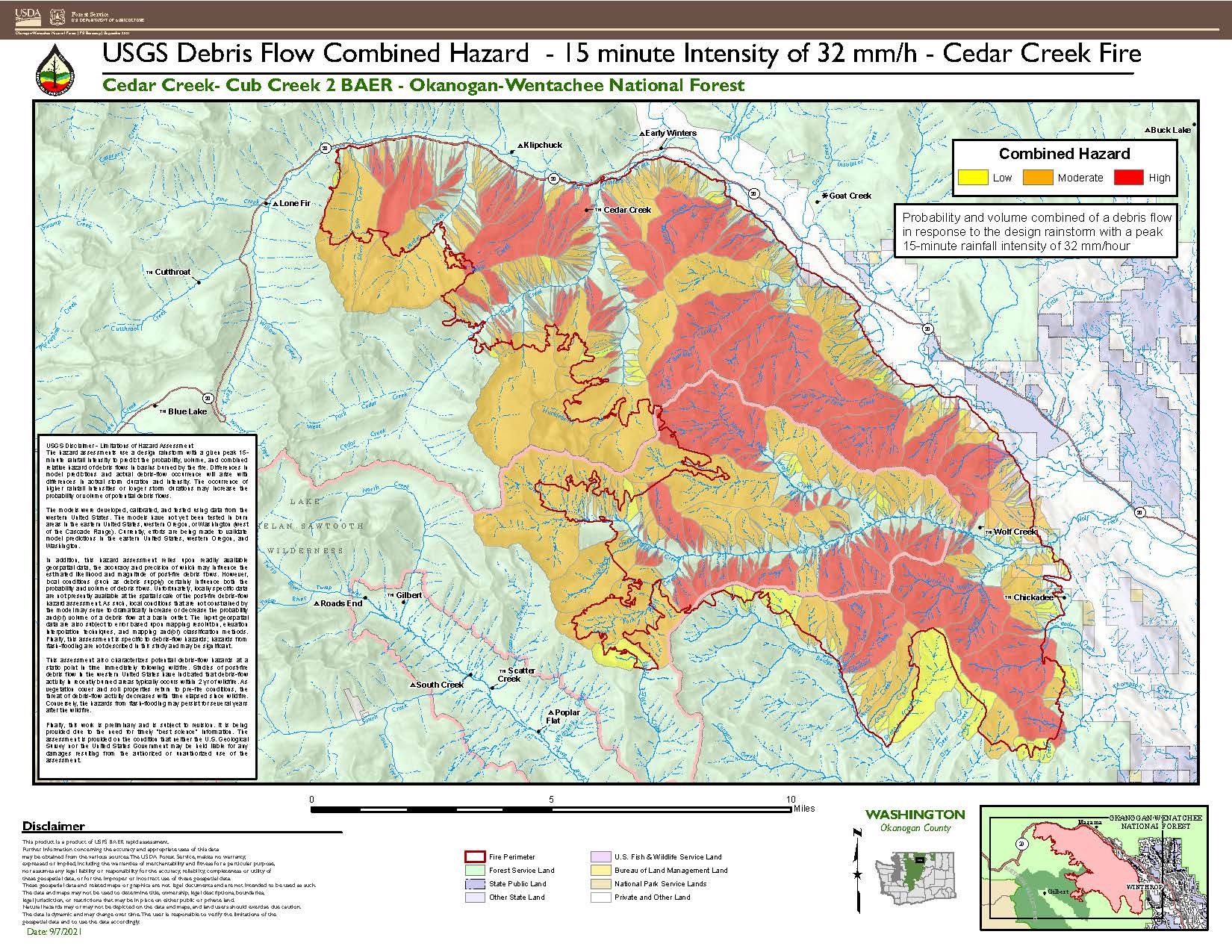
WINTHROP, WA– The Cub Creek 2 and Cedar Creek Fire Burned Area Emergency Response (BAER) Team coordinated with the US Geological Survey (USGS) during its evaluation of the burned area to assess potential post-fire hazards, including debris flows.
The USGS utilized the BAER team’s soil burn severity map to model potential debris flow hazards within the burned area. The resulting Debris Flow Hazard Map displays the combined relative debris flow hazard for areas burned by the Cub Creek 2 and Cedar Creek Fires. The combined relative hazard metric is a combination of the likelihood of debris flow (in %) and potential volume of debris flow (in m3).
Probabilities are calculated based on a typical storm for this area, which are described by both their intensity and volume. On the Okanogan-Wenatchee NF, in any given year, there’s a 20% probability of a 15 min intensity / 32 mm per hour storm occurring during a one-hour rainstorm. That means that over a 15-minute period, we could expect to receive 8 mm (~0.32 inches) of rain.
“Having a storm that produces about a third of an inch of rain over a 15-minute period is not uncommon for this forest, so we decided to use that as our “model storm” for analysis,” said hydrologist Molly Hanson. “At that intensity, there are multiple watersheds within the burned area that have the potential to produce debris flows.”
Many watersheds within the burned area have a relatively high probability of experiencing a debris flow. On the Cub Creek 2 Fire, multiple basins that feed into Eightmile Creek, Falls Creek, and the main stem of the Chewuch River are at high risk (>60% probability) in response to expected storm intensity. On Cedar Creek, multiple basins in Wolf Creek, Methow River Valley, and along Highway 20 on the north of the fire also have a high probability of experiencing a debris flow (see accompanying maps).
This information is extremely important as we all need to improve our safety awareness of the areas, especially where there may be an increased risk of hillslope erosion, flooding sediment delivery to streams, and a higher probability of debris flows – all of which are potential risks to human life, safety, and property.
While the USGS delivers debris flow hazard potential to BAER teams for multiple storm designs, their website only displays results using a standard storm design for all fires across the country: 15 min / 24 mm/h. Please be aware of the differences between their visualization and local implementation due to site-specific hydrological experience.
USGS debris flow combined hazard maps are available in both JPEG and PDF formats and can be viewed and downloaded under the "Related Information" header below or the "Maps" tab of this InciWeb site. Maps will also be available at http://www.centralwashingtonfirerecovery.info/

SPECIAL NOTE: Everyone near and downstream from the Cub Creek 2 and Cedar Creek Fires burned area should remain alert and stay updated on weather conditions. Flash flooding could occur quickly during heavy rain events. Current weather and emergency notifications can be found at the National Weather Service (NWS), Spokane (OTX) (https://www.weather.gov/otx/) website.
Central Washington USFS BAER information is available at http:/www.centralwashingtonfirerecovery.info
Burned Area Emergency Response BAER Limitations
Related Incident:
Publication Type: News
Burned Area Emergency Response (BAER) Limitations
While many wildfires cause minimal damage to the land and pose few threats to the land or people downstream, some fires result in damage that requires special efforts to reduce impacts afterwards. Loss of vegetation exposes soil to erosion; water run-off may increase and cause flooding, soil and rock may move downstream and damage property or fill reservoirs putting community water supplies and endangered species at-risk.
The Burned Area Emergency Response (BAER) program is designed to identify and manage potential risks to resources on National Forest System lands and reduce these threats through appropriate emergency measures to protect human life and safety, property, and critical natural or cultural resources. BAER is an emergency program for stabilization work that involves time- critical activities to be completed before the first damaging storm event to meet program objectives.
BAER Objectives:
- Determine whether imminent post-wildfire threats to human life and safety, property, and critical natural or cultural resources on National Forest System lands exist and take immediate actions, as appropriate, to manage the unacceptable risks.
- If emergency conditions are identified, mitigate significant threats to human life and safety, Forest Service property and other critical natural and cultural resource values.
- Prescribe emergency response actions to stabilize and prevent unacceptable degradation to natural and cultural resources, to minimize threats to life or property resulting from the effects of a fire, or to repair/replace/construct physical improvements necessary to prevent degradation of land or resources.
- Implement emergency response actions to help stabilize soil; control water, sediment and debris movement and potentially reduce threats to the BAER critical values identified above when an analysis shows that planned actions are likely to reduce risks substantially within the first year following containment of the fire.
- Monitor the implementation and effectiveness of emergency treatments that were applied on National Forest System lands.
BAER Interagency Coordination:
Post-fire emergency response is a shared responsibility. There are several Federal, State and local agencies that have emergency response responsibilities or authorities in the post-fire environment. The BAER team coordinates with these agencies to look at the full scope and scale of the situation to reduce the potential threats to human life and property. It is important that BAER efforts are communicated with all affected and interested cooperating agencies and organizations regarding other post-fire recovery and restoration efforts.
BAER treatments cannot prevent all of the potential flooding or soil erosion impacts, especially after a wildfire-changed landscape. It is important for the public to stay informed and prepared for potentially dramatic increased run-off events.
One of the most effective BAER strategies is interagency coordination to provide post-fire threat information to local cooperators who can assist affected businesses, homes, and landowners to prepare for rain events. For example, the Natural Resources Conservation Service (NRCS) has the Emergency Watershed Protection (EWP) program for post-emergency assistance on private and tribal land, the National Weather Service (NWS) has responsibility for flood warning alerts, the Federal Emergency Management Agency (FEMA) has flood insurance and other responsibilities if the area is a Presidentially-declared emergency, Resource Conservation Districts (RCD) and counties, as well as State and local-highway and emergency services departments, Flood Control authorities, etc. It is important that landowners work directly with NRCS and other agencies to determine appropriate actions needed to protect private structures and other assets.
BAER Process:
BAER assessment teams are staffed by specially trained professionals that may include: hydrologists, soil scientists, engineers, biologists, botanists, archeologists, and others who evaluate the burned area and prescribe temporary emergency stabilization actions on National Forest System lands to protect the land quickly and effectively. BAER assessments usually begin before a wildfire has been fully contained.
A BAER assessment team conducts field surveys and uses science-based models to rapidly evaluate and assess the burned area and prescribe emergency stabilization measures. The team generates a “Soil Burn Severity” map by using satellite imagery which is then validated and adjusted by BAER team field surveys to assess watershed conditions and model potential watershed response from the wildfire. The map identifies areas of soil burn severity by categories of very low/unburned, low, moderate, and high which may correspond to a projected increase in watershed response. The higher the burn severity, the less the soil will be able to absorb water when it rains. Without absorption, there will be increased run-off with the potential of flooding.
The BAER team presents these findings in an assessment report that identifies immediate and emergency actions needed to address post-fire risks to human life and safety, property, cultural and critical natural resources. This includes early detection and rapid response (EDRR) treatments to prevent the spread of noxious weeds into native plant communities. The BAER report describes watershed pre- and post-fire watershed response information, areas of concern for life and property, and recommended short-term emergency stabilization measures for Forest Service lands that burned.
In most cases, only a portion of the burned area is actually treated. Severely burned areas steep slopes, and places where water run-off will be excessive and may impact important resources, are focus areas and described in the BAER assessment report if they affect critical values. Response action timing is essential to ensure the emergency stabilization measures are effective.
There are a variety of emergency stabilization actions that the BAER team can recommend for Forest Service land such as mulching with agricultural straw or chipped wood to protect soil productivity, increasing road drainage to keep roads and bridges from washing-out during post-fire floods, and early detection rapid response invasive plant treatments to prevent spread of weeds into native plant communities. BAER treatments are preventative in nature but cannot prevent all damage, especially debris torrents in areas that are prone to sliding and have lost critical root structure from plants.
The Cans and Cannots of BAER:
- What BAER Can Do
- Install water or erosion control devices
- Seed or mulch for erosion control or stability reasons
- Install erosion control measures at critical cultural sites
- Install temporary barriers to protect treated or recovering areas
- Install warning signs
- Replace minor safety related facilities, like burned guard rails
- Install appropriate-sized drainage features on roads or trails
- Remove critical safety hazards
- Prevent permanent loss of threatened and endangered species habitat
- Monitor BAER treatments
- Implement treatments to minimize the spread of noxious weeds into native plant communities
- What BAER Cannot Do
- Prevent all flooding and debris flows
- Replant commercial forests or grass for forage
- Excavate and interpret cultural sites
- Replace burned pasture fences
- Install interpretive signs
- Replace burned buildings, bridges, corrals, etc.
- Repair roads damaged by floods after fire
- Remove all hazard trees
- Replace burned habitat
- Monitor fire effects
- Treat pre-existing noxious weeds
BAER Funding:
Special Emergency Wildfire Suppression funds are authorized for BAER activities and the amount of these expenses varies with the severity of the fire season. Some years see little BAER activity while other years are extremely busy.
Because of the emergency nature of BAER, initial requests for funding of proposed BAER treatments are supposed to be submitted by the Forest Supervisor to the Regional Office within 7 days of total containment of the fire. The Regional Forester’s approval authority for individual BAER projects is limited. Approval for BAER projects exceeding this limit is forwarded onto the Washington Office.Soil Burn Severity Mapping Completed
Related Incident:
Publication Type: Announcement
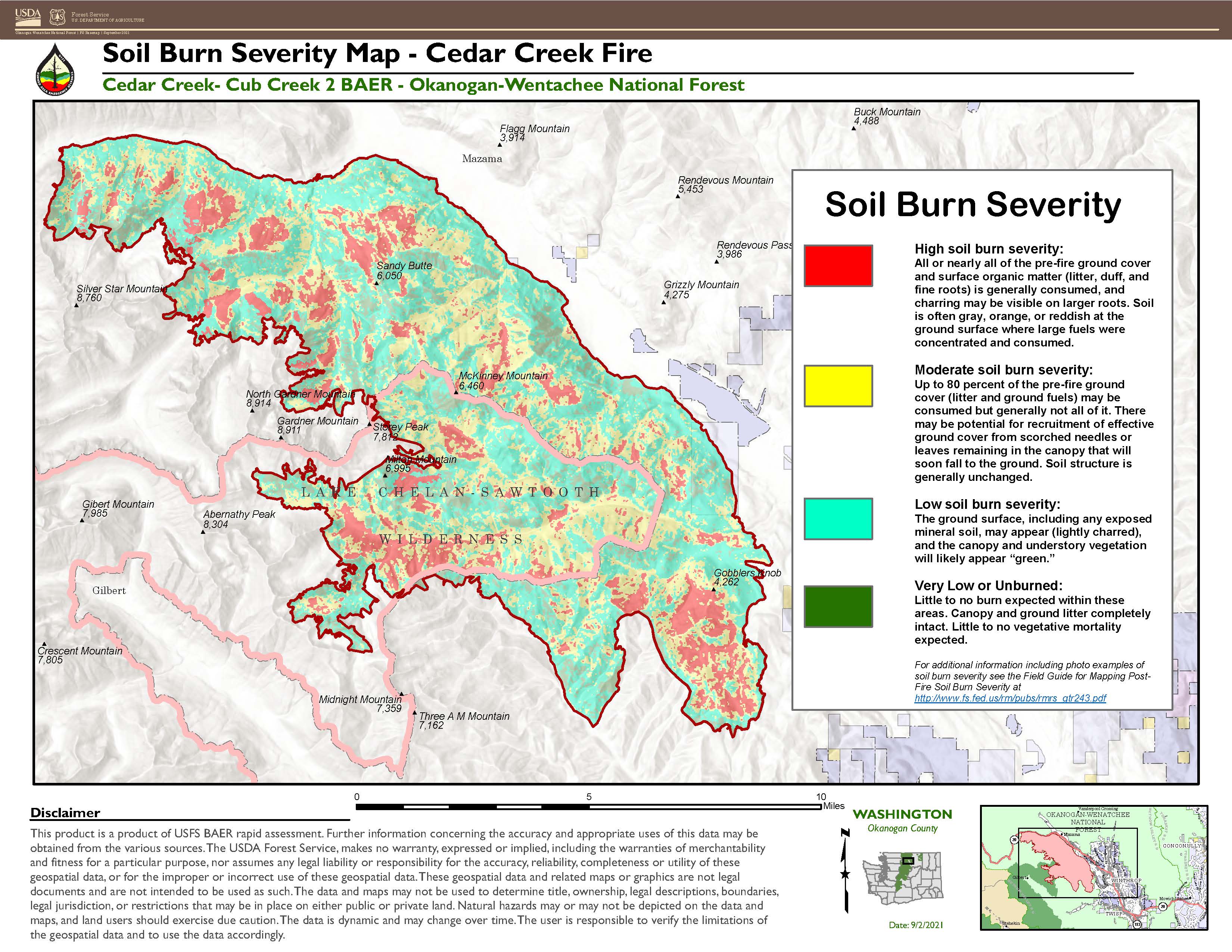
Winthrop, Washington—Burned Area Emergency Response (BAER) specialists recently completed data gathering and analysis for the area burned in the Cub Creek 2 and Cedar Creek Fires to produce soil burn severity maps for each fire. Developing a postfire soil burn severity map is an important first step in the rapid assessment process. It enables BAER teams to prioritize field reviews and identify areas that may pose a risk to critical values within or downstream of the burned area. The map displays soil burn severity in four categories: areas of very low or unburned, low, moderate, or high.
The Cub Creek 2 Fire burned a total of 70,818 acres: 18% very low or unburned, 41% low, 26% moderate, and 15% high.
The Cedar Creek Fire burned a total of 55,248 acres. 11% very low or unburned, 41% low, 33% moderate, and 15% high.
The soil burn severity maps are available in both JPEG and PDF formats and can be viewed and downloaded under the "Related Information" header below or the "Maps" tab of this InciWeb site. Maps will also be available at http://www.centralwashingtonfirerecovery.info/

Soil Burn Severity
Very Low or Unburned – This category of soil burn severity indicates little to no observable change to the vegetation condition, particularly from overhead canopy perspective.
Low - The low category of soil burn severity indicates that there was only partial consumption of fine fuels and litter coverage still remains, to some extent, on the soil surface. Fire residence time at the soil surface in low areas was short, leaving root systems and structure intact. Recovery time in the low category will vary based on ecological community but is expected to be relatively short.
Moderate - A moderate category of soil burn severity indicates consumption of litter and fine fuels at the soil surface. In forested communities, the heat from moderate severity fire will result in water repellant conditions at the mineral soil surface. The canopy in the moderate forested system is browning and it is expected that trees in this area will drop needles and leaves that can provide some litter cover at the soil surface. In these systems, recovery can take longer for tree species to reestablish.
High - A high soil burn severity category is the result of higher intensity fire behavior or longer residence time at the soil surface. This category is found in forested or dense woodland communities and the litter and fuels, including an overstory canopy, was consumed. The soil structure is weakened, roots are charred, and water repellant soil conditions persist through the upper horizon of mineral soil. Recovery time in the conifer systems can be significant.
After the Fire Toolkits
Related Incident:
Publication Type: News
AFTER THE FIRE: Toolkits
US Department of Agriculture After the Fire Toolkit
https://postfiresw.info/
The US Department of Agriculture After the Fire Toolkit website has information and guidance for resource managers, landowners, and communities for assessing and preventing potential damage due to post-fire flooding and related events. This site has information on the research, methods, and tools available for assessing and reducing risks associated with post-fire flooding, debris flows and sedimentation.
After the Fire Washington
https://afterthefirewa.org/
https://afterthefirewa.org/community-assistance/after-fire-toolkit/
Another after the fire toolkit designed to allow community coalitions, local wildfire coordinating groups, fire districts and other organizations respond to post-fire community needs quickly, accurately, and comprehensively.
Key Elements of a BAER Assessment
Related Incident:
Publication Type: News
KEY ELEMENTS OF A BAER ASSESSMENT
Forest Service BAER assessment teams are established by Forest Supervisors before wildfires are fully contained. The teams coordinate and work with the USDA Natural Resources Conservation Service (NRCS), Bureau of Land Management (BLM), Fish & Wildlife Service (FWS), National Weather Service (NWS), local counties, State Department of Transportation, and other federal, state, and local agencies to strategically assess potential post-fire impacts to the watersheds burned from wildland fires.
- The BAER assessment teams are evaluating watershed conditions to determine the level of potential risks to human life, safety, property, critical natural and cultural-heritage resources, and determine if there are appropriate and effective emergency stabilization measures that can be implemented on federal lands in a timely manner to reduce unacceptable risks from potential flooding and debris flow threats.
- The BAER assessment team conducts field surveys and uses science-based models to rapidly evaluate and assess the burned area.
- BAER assessment teams are staffed by specially trained professionals that may include: hydrologists, soil scientists, engineers, geologists, biologists, botanists, archeologists, geographic information system mapping specialists, recreation and trails specialists, and others who evaluate the burned area and prescribe emergency response actions to protect the land quickly and effectively.
- BAER assessments usually begin before a wildfire has been fully contained.
- The BAER assessment team generates a “Soil Burn Severity” map by using satellite imagery which is then validated and adjusted by BAER team field surveys to assess watershed conditions and watershed response to the wildfire. The map identifies areas of soil burn severity by categories of low/unburned, moderate, and high which corresponds to a projected increase in watershed response.
- The BAER team presents these findings and treatment recommendations to the Forest Supervisor in an assessment report that identifies immediate and emergency stabilization actions needed to address potential post-fire risks to human life and safety, property, cultural-heritage and critical natural resources on National Forest System lands.
- The BAER report describes watershed pre- and post-fire response information, areas of concern for human life, safety and property, and recommended short-term emergency stabilization actions for federal lands that burned.
- In most cases, only a portion of the burned area is actually treated.
- If the BAER assessment team determines there may be potential emergency situations, the short-term goal is to have flood and erosion control protection measures completed before the first large, damaging rain events occur.
- Timely implementation is critical if BAER emergency response actions are to be effective.
- The BAER assessment team coordinates with other federal and local agencies, and counties that assist private landowners in preparing for increased run-off and potential flooding.
- Federal assistance to private landowners regarding post-fire potential impacts is the primary responsibility of the NRCS through the Emergency Watershed Protection (EWP) program (www.nrcs.usda.gov/wps/portal/nrcs/main/national/programs/landscape/ewpp/).
- NRCS in coordination with additional state, local and federal agencies conduct damage survey reports for the private land adjacent to and downstream from the burned areas. NRCS uses these reports, along with the BAER team’s assessment report, to develop recommended emergency measures for businesses and private home and landowners to reduce the impacts to their property from potential increased water and debris flows.
Forest Service BAER Program Overview
Related Incident:
Publication Type: News
FOREST SERVICE BAER PROGRAM OVERVIEW
The Burned Area Emergency Response (BAER) program is designed to identify and manage potential risks to resources on National Forest System lands and reduce these threats through appropriate emergency measures to protect human life and safety, property, and critical natural or cultural resources. BAER is an emergency program for stabilization work that involves time-critical activities to be completed before the first damaging event to meet program objectives.
BAER Objectives:
- Determine whether imminent post-wildfire threats to human life and safety, property, and critical natural or cultural resources on National Forest System lands exist and take immediate actions, as appropriate, to manage the unacceptable risks.
- If emergency conditions are identified, mitigate significant threats to health, safety, human life, property and critical cultural and natural resources.
- Prescribe emergency response actions to stabilize and prevent unacceptable degradation to natural and cultural resources, to minimize threats to critical values resulting from the effects of a fire, or to repair/replace/construct physical improvements necessary to prevent degradation of land or resources.
- Implement emergency response actions to help stabilize soil; control water, sediment and debris movement and potentially reduce threats to the BAER critical values identified above when an analysis shows that planned actions are likely to reduce risks substantially within the first year following containment of the fire.
- Monitor the implementation and effectiveness of emergency treatments that were applied on National Forest System lands.
While many wildfires cause minimal damage to the land and pose few threats to the land or people downstream, some fires result in damage that requires special efforts to reduce impacts afterwards. Loss of vegetation exposes soil to erosion; water run-off may increase and cause flooding, soil and rock may move downstream and damage property or fill reservoirs putting community water supplies and endangered species at-risk.
The BAER team presents these findings in an assessment report that identifies immediate and emergency actions needed to address post-fire risks to human life and safety, property, cultural and critical natural resources. This includes early detection and rapid response (EDRR) treatments to prevent the spread of noxious weeds into native plant communities. The BAER report describes watershed pre- and post-fire watershed response information, areas of concern for life and property, and recommended short-term emergency stabilization measures for Forest Service lands that burned.
In most cases, only a portion of the burned area is actually treated. Severely burned areas steep slopes, and places where water run-off will be excessive and may impact important resources, are focus areas and described in the BAER assessment report if they affect critical values. Time is critical if the emergency stabilization measures are to be effective.
A BAER assessment team conducts field surveys and uses science-based models to rapidly evaluate and assess the burned area and prescribe emergency stabilization measures. The team generates a “Soil Burn Severity” map by using satellite imagery which is then validated and adjusted by BAER team field surveys to assess watershed conditions and model potential watershed response from the wildfire. The map identifies areas of soil burn severity by categories of very low/unburned, low, moderate, and high which may correspond to a projected increase in watershed response. The higher the burn severity, the less the soil will be able to absorb water when it rains. Without absorption, there will be increased run-off with the potential of flooding.
BAER Funding:
Special Emergency Wildfire Suppression funds are authorized for BAER activities and the amount of these expenses varies with the severity of the fire season. Some years see little BAER activity while other years are extremely busy.
Because of the emergency nature of BAER, initial requests for funding of proposed BAER treatments are supposed to be submitted by the Forest Supervisor to the Regional Office within 7 days of total containment of the fire. The Regional Forester’s approval authority for individual BAER projects is limited. Approval for BAER projects exceeding this limit is to the Washington Office.
Greenwood Fire Update September 14 2021
Related Incident:
Publication Type: News
WEATHER/FIRE BEHAVIOR: Today there is a 20% chance of showers until 9:00. Skies will be mostly cloudy until noon, then mostly sunny. High temperatures will be from 67-71 with relative humidity between 40-52%. West winds will be from 2-11 mph, shifting to the northwest late in the afternoon with gusts up to 19 mph. Despite sunny weather, no fire movement is anticipated.
· Highway 1 is closed from the Highway 1 and Highway 2 intersection to Lankinen Road and only property owners with passes issued by the Sheriff’s Office may travel along the highway. Highway 2 is open to all traffic.
· National Forest System lands, roads and recreation areas are closed in the area of the Greenwood Fire to protect public health and safety. The closure area extends across the Kawishiwi, Laurentian, and Tofte Ranger Districts and includes several Boundary Waters Canoe Area Wilderness Entry Points. To see the full Forest order and other Forest closures, visit https://www.fs.usda.gov/superior.
Recording of Community Meeting
Related Incident:
Publication Type: Announcement
Okanogan County Emergency Management posted a recording of the Cub/Cedar Creek community meeting from Wednesday, September 22. The video is linked from their website (see below).