
Hermits Peak Calf Canyon Fire Daily Update June 17 2022
Related Incident: Hermits Peak Fire
Publication Type: News
Hermits Peak and Calf Canyon Fires
June 17, 2022, Daily Update, 08:00 AM
Acres: 340,980
Containment: 72%
Total personnel: 2279 Start Date: Hermits Peak: April 6, 2022; Calf Canyon: April 19, 2022
Cause: Hermits Peak: Spot fires from prescribed burn; Calf Canyon: Holdover fire from prescribed pile burn
Location: Located near Gallinas Canyon
Fuels: Heavy mixed conifer, ponderosa pine, brush, and grass
Highlights: Yesterday, the fire displayed active behavior on the west side, creating growth across the Pecos River and to the north-northwest. This activity led to an increase of smoke in the North Zone of the fire area. Forecast higher humidity and lower temperatures have improved the fire outlook today while increasing the possibility of debris flow and flooding. Firefighting resources remain engaged along the western edge of the fire today and are prepared for flood-related emergencies across the fire area. The public is urged to review flood preparation and monitoring guidelines, available on the fire’s social media and public safety agencies (see below).
Operations:
North Zone (SWIMT1): A shift in wind yesterday moved fire on the western edge northward into an area of heavy dead and down timber in the Pecos Wilderness north of the Beatty Cabin. Firefighters monitor fire growth along this edge as it moves toward the ridge system from North Truchas to Jicarita Peak and work to prevent spread to the north through identified areas of breech in this natural fire barrier. In the north fuel break, all feller/buncher operations to remove fuel have been completed. Skidders will continue to move material for another day. Road improvements to support trucks that are moving material out of north fuel break and Osha Pass is ongoing. Suppression repair operations continue at a rapid pace. A new fire south of Angel Fire was reported and rapidly contained to a 10 by 10-foot area using helicopters and engines that were already in the area.
South Zone (SWIMT5): Fire behavior remained very active in the wilderness area yesterday, causing a spot fire to cross the Pecos River and push northwest into down and dead timber. Winds shifted from south-southwest to southeast, which, combined with the thick timber, led to the increased fire activity along the Pecos River. The steep wilderness slopes allowed terrain driven fire activity to push flames 100 to 150 feet up in the air. Despite the potential for wetting rains, fire behavior will continue to be active today. Crews will continue to monitor the fire for opportunities to conduct strategic firing operations or construct direct fireline if weather and fire behavior are favorable. Several pieces of equipment will be staged to support local counties if there are flash floods. Initial attack fire fighters remain ready to assist with any possible lightning strikes. Evacuation orders for several areas in San Miguel County have been lifted. Please see the map below.
Evacuations: For updated evacuation information from the Hermits Peak and Calf Canyon Fires: www.tinyurl.com/hermitspeak. The Ready, Set, Go evacuation guide is available in English and Spanish here: https://tinyurl.com/RSGNM. For disaster assistance resources, visit: https://www.nmdhsem.org/2022-wildfires/.
Weather: Moisture from a southerly surge will have worked into the area to support wetting storms with a south to north direction expected. Moderating fire weather conditions are expected along with increasing threats for flash flooding in the burn scar area. Winds will remain out of the south with gusts up to 25 mph. Minimum relative humidity will trend up around 15 to 20% with values in the 20 to 35% range.
Closures and Restrictions: All National Forests in New Mexico have closures or restrictions in place due to extreme fire danger. To learn more about these closures and restrictions, visit: https://tinyurl.com/bdy5y99r. Information related to fire restrictions across public and private land can be found at: https://nmfireinfo.com/fire-restrictions/.
After Fire Flooding and Recovery Resources: Interactive flood and debris flow map: www.tinyurl.com/hermitspeak After Wildfire New Mexico guide: https://www.afterwildfirenm.org/ | Hermits Peak & Calf Canyon Fire Burned Area Emergency Response information https://inciweb.nwcg.gov/incident/8104/.
Suppression Repair Property Survey: land owners within the fire area can complete this survey for assistance with suppression repair on their property: https://www.tinyurl.com/suppressionrepair
Smoke: An interactive smoke map at fire.airnow.gov/ allows you to zoom into your area to see the latest smoke conditions.
Fire Information: Office Hours: 8:00 AM – 8:00 PM | Phone: 505-356-2636 | Email: 2022.hermitspeak@firenet.gov
Online: inciweb.nwcg.gov/incident/8069/ | https://www.facebook.com/CalfCanyonHermitsPeak | nmfireinfo.com |tinyurl.com/HermitsYouTube | Santa Fe NF
Hermits Peak Calf Canyon Fire Update for June 16 2022
Related Incident: Hermits Peak Fire
Publication Type: News
Hermits Peak and Calf Canyon Fires
June 16, 2022, Daily Update, 08:00 AM
Acres: 336,638
Containment: 72%
Total personnel: 2,150 Start Date: Hermits Peak: April 6, 2022; Calf Canyon: April 19, 2022
Cause: Hermits Peak: Spot fires from prescribed burn; Calf Canyon: Holdover fire from prescribed pile burn
Location: Located near Gallinas Canyon
Fuels: Heavy mixed conifer, ponderosa pine, brush, and grass
Highlights: A very dry air mass is driving fire activity. Yesterday with gusts and outflow winds, fire continued to back into the Pecos River System. Forecasted dry thunderstorms today have the potential to cause localized increased fire activity. As storms transition to wetting rain over the weekend, fire personnel are preparing for the possibility of dangerous debris flow and flooding from the burned areas. To better monitor rainfall, especially along the 518 corridors, Remote Automated Weather Stations (RAWS) are being relocated. The Mora fire camp is closing as fire managers move resources to more strategic locations. A live virtual community meeting will be hosted tomorrow at 6 p.m. on the Hermits Peak and Calf Canyon Fire Facebook Page.
Operations:
North Zone (SWIMT1): The northwestern division of the fire above NM Hwy 518 continued preparing contingency lines, grading, chipping, using masticators, and removing material. Progress is continuing on the north contingency line as road improvement is completed, allowing access to the line from the 518 rd. Suppression repair work continues in the east and south, with fence line repair completed west of NM 121. Repair teams are moving into Sierra Bonita and the 434 road. An initial attack task force is in place to support local units in the event of new starts. Firefighters continue to patrol, monitor, and hold the existing fire lines.
South Zone (SWIMT5): Fire activity remains high as near record setting temperatures and strong winds continue, creating highly visible smoke throughout the fire area. Winds will continue to push from the west, keeping humidity low and temperatures high. Active areas of the fire from Tuesday will continue to remain active, primarily around the Rio Mora drainage and the Trampas Fire burn scar as the fire pushes up slope. The fire has not crossed the Hamilton Mesa Trail and continues to burn towards the northeast, into the wilderness. The fire will also continue to consume interior islands of unburned fuel within the fire perimeter throughout today's burning period. Crews continue to focus on repair work along the Skyline Trail, which include chipping, mop-up efforts, and cleaning up downed debris and dozer line. Firefighters continue to monitor and suppress fire activity along Hamilton Mesa Trail. Crews will also continue with structure protection around Beatty’s Cabin and North Pecos. There are no changes to road closures or evacuation orders in the fire area.
Evacuations: To view real-time evacuation information around the Hermits Peak and Calf Canyon Fires, visit: https://tinyurl.com/HermitsPeak for the evacuation map. The Ready, Set, Go evacuation guide is available in English and Spanish here: https://tinyurl.com/RSGNM. For disaster assistance resources, visit: https://www.nmdhsem.org/2022-wildfires/.
Weather: Dry thunderstorms are forecast for Friday, changing to thunderstorms with wetting rain over the weekend. For potential flooding information, visit an interactive map at: http://tinyurl.com/calfcanyonfloodmap
Closures and Restrictions: All National Forests in New Mexico have closures or restrictions in place due to extreme fire danger. To learn more about these closures and restrictions, visit: https://tinyurl.com/bdy5y99r. Information related to fire restrictions across public and private land can be found at: https://nmfireinfo.com/fire-restrictions/.
After Fire Flooding and Recovery Resources: After Wildfire New Mexico guide https://www.afterwildfirenm.org/ | Hermits Peak & Calf Canyon Fire Burned Area Emergency Response information https://inciweb.nwcg.gov/incident/8104/.
Suppression Repair Property Survey: Suppression repair is a series of immediate post-fire actions taken to repair damages and minimize potential soil erosion and impacts resulting from fire suppression activities and usually begins before the fire is contained, and before the demobilization of an Incident Management Team. To request support with suppression repair activities: https://www.tinyurl.com/suppressionrepair
Smoke: An interactive smoke map at fire.airnow.gov/ allows you to zoom into your area to see the latest smoke conditions.
Fire Information: Office Hours: 8:00 AM – 8:00 PM | Phone: 505-356-2636 | Email: 2022.hermitspeak@firenet.gov Online: inciweb.nwcg.gov/incident/8069/ | https://www.facebook.com/CalfCanyonHermitsPeak| nmfireinfo.com |tinyurl.com/HermitsYouTube | Santa Fe NF |
Hermits Peak Calf Canyon Fire Update for June 15 2022
Related Incident: Hermits Peak Fire
Publication Type: News
Hermits Peak and Calf Canyon Fires
June 15, 2022, Daily Update, 08:00 AM
Acres: 335,069 | Containment: 70% | Total personnel: 2,199 | Start Date: Hermits Peak: April 6, 2022; Calf Canyon: April 19, 2022 | Cause: Hermits Peak: Spot fires from prescribed burn; Calf Canyon: Holdover fire from prescribed pile burn | Location: Located near Gallinas Canyon | Fuels: Heavy mixed conifer, ponderosa pine, brush, and grass
Highlights: A live virtual community meeting will be hosted on the Hermits Peak and Calf Canyon Fire Facebook Page. The fire is increasing in activity based on the predicted Red Flag conditions we are currently experiencing over the fire area. The fire perimeter on the west side expanded to the northwest, toward Hamilton Mesa. Suppression repair work in the North and South Zones is progressing, and crews are working to construct water bars on steep slopes to minimize resource damage when the monsoons arrive. Private property owners are advised to complete the suppression repair survey. See the Suppression Repair Property Survey section below for more information.
Operations:
North Zone (SWIMT1): With the increased fire activity in south zone, the northwestern division of the fire coordinated additional look-out positions to provide increased awareness and safety for firefighters on the ground. Wildland fire modules, which are a specialized small crew of firefighters who focus on monitoring and suppression planning in remote areas, are assigned to the western side of the zone providing additional situational awareness as fire activity increased. Work continues on control lines. Use of mechanized equipment was stopped mid-day due to risk of igniting new starts. Suppression repair progresses steadily, including repair work being completed north of Chacon and along the northeast corner of the fire perimeter along the 434 corridor. An initial attack task force is in place to support local units in the event of new starts.
South Zone (SWIMT2): Fire activity remains high as near record setting temperatures and strong winds continue, creating highly visible smoke throughout the fire area. Winds will continue to push from the west, keeping humidity low and temperatures high. Active areas of the fire from Tuesday will continue to remain active, primarily around the Rio Mora drainage and the Trampas Fire burn scar as the fire pushes up slope. The fire has not crossed the Hamilton Mesa Trail and continues to burn towards the northeast, into the wilderness. The fire will also continue to consume interior islands of unburned fuel within the fire perimeter throughout today's burning period. Crews continue to focus on repair work along the Skyline Trail, which include chipping, mop-up efforts, and cleaning up downed debris and dozer line. Firefighters continue to monitor and suppress fire activity along Hamilton Mesa Trail. Crews will also continue with structure protection around Beatty’s Cabin and North Pecos. There are no changes to road closures or evacuation orders in the fire area.
Evacuations: To view real-time evacuation information around the Hermits Peak and Calf Canyon Fires, visit: https://tinyurl.com/HermitsPeak for the evacuation map. The Ready, Set, Go evacuation guide is available in English and Spanish here: https://tinyurl.com/RSGNM. For disaster assistance resources, visit: https://www.nmdhsem.org/2022-wildfires/.
Weather: Minimum relative humidity values will drop down into the single digits and low teens along with wind gusts up to 40 mph. An isolated dry thunderstorm cannot be ruled out due to high level moisture and instability moving across the fire area, but the threat is low.
Closures and Restrictions: All National Forests in New Mexico have closures or restrictions in place due to extreme fire danger. To learn more about these closures and restrictions, visit: https://tinyurl.com/bdy5y99r. Information related to fire restrictions across public and private land can be found at: https://nmfireinfo.com/fire-restrictions/.
After Fire Flooding and Recovery Resources: After Wildfire New Mexico guide https://www.afterwildfirenm.org/ | Hermits Peak & Calf Canyon Fire Burned Area Emergency Response information https://inciweb.nwcg.gov/incident/8104/.
Suppression Repair Property Survey: Suppression repair is a series of immediate post-fire actions taken to repair damages and minimize potential soil erosion and impacts resulting from fire suppression activities and usually begins before the fire is contained, and before the demobilization of an Incident Management Team. To request support with suppression repair activities: https://www.tinyurl.com/suppressionrepair
Smoke: An interactive smoke map at fire.airnow.gov/ allows you to zoom into your area to see the latest smoke conditions.
Fire Information: Office Hours: 8:00 AM – 8:00 PM | Phone: 505-356-2636 | Email: 2022.hermitspeak@firenet.gov Online: inciweb.nwcg.gov/incident/8069/ | https://www.facebook.com/CalfCanyonHermitsPeak| nmfireinfo.com |tinyurl.com/HermitsYouTube | Santa Fe NF |
Hermits Peak Calf Canyon Fire Daily Update June 14 2022
Related Incident: Hermits Peak Fire
Publication Type: News
Hermits Peak and Calf Canyon Fires
June 14, 2022, Daily Update, 08:00 AM
Acres: 325,340 | Containment: 70% | Total personnel: 2,252 | Start Date: Hermits Peak: April 6, 2022; Calf Canyon: April 19, 2022 | Cause: Hermits Peak: Spot fires from prescribed burn; Calf Canyon: Holdover fire from prescribed pile burn | Location: Located near Gallinas Canyon | Fuels: Heavy mixed conifer, ponderosa pine, brush, and grass
Highlights: A Red Flag Warning is in effect from 12:00 PM to 8:00 PM, expect to see increased smoke as the fire remains active today, including in unburned islands of fuel in the interior. Southwest Area Incident Management Team 5 assumed command of the South Zone. Suppression repair work in the North and South Zones is progressing, and crews are working to construct water bars on steep slopes to minimize resource damage when the monsoons arrive.
Operations:
North Zone (SWIMT1): Yesterday, as expected there was an increase in interior pockets of fuel burning out during the day with the increased winds and atmospheric instability. Crews continued to monitor along the western flank of the fire while work on the shaded fuel breaks progressed. Suppression repair work continued in the Chacon area, with firefighters working south down NM Highway 121 along the fire perimeter. Firefighters will continue with suppression repair work along Hwy 434 area as well. With support from aviation, fire managers will continue to monitor the western edge of the fire, ensuring that the containment lines continue to hold strong. Work will continue with the shaded fuel breaks to the north and northwest of the fire.
South Zone (SWIMT2): Fire activity continues to be high with hot, dry conditions and strong southwest winds creating extremely visible smoke, specifically from the Pecos Wilderness. Communities on the eastern side of the fire will see larger amounts of smoke in comparison to the last several days. Active areas of the fire from Tuesday are anticipated to remain active, primarily around the Rio Mora drainage and the Trampas fire burn scar. The fire moved into Rio Mora drainage Tuesday and continues to move towards Hamilton Mesa within the Pecos Wilderness. Smoke will be visible as areas of unburned fuel within the perimeter dry due to the record setting high temperatures and low relative humidity. Crews focused on repair work yesterday along the Skyline Trail, to include chipping and mop up efforts. Today, crews will focus efforts on the Skyline Trail, cleaning up downed debris and dozer line used as containment line earlier in the fire. Firefighters along Hamilton Mesa will continue to monitor and assess for potential strategic burning operations. There are no changes to road closures or evacuation orders in the fire area.
Evacuations: To view real-time evacuation information around the Hermits Peak and Calf Canyon Fires, visit: https://tinyurl.com/HermitsPeak for the evacuation map. The Ready, Set, Go evacuation guide is available in English and Spanish here: https://tinyurl.com/RSGNM. For disaster assistance resources, visit: https://www.nmdhsem.org/2022-wildfires/.
Weather: A Red Flag Warning has been issued for Tuesday with very low relative humidity, gusty westerly winds and an unstable hot airmass bringing critical fire weather conditions to the fire area. Minimum relative humidity values will drop down into the single digits and low teens along with wind gusts up to 40 mph. An isolated dry thunderstorm cannot be ruled out due to high level moisture and instability moving across the fire area, but the threat is low.
Closures and Restrictions: All National Forests in New Mexico have closures or restrictions in place due to extreme fire danger. To learn more about these closures and restrictions, visit: https://tinyurl.com/bdy5y99r. Information related to fire restrictions across public and private land can be found at: https://nmfireinfo.com/fire-restrictions/.
After Fire Flooding and Recovery Resources: After Wildfire New Mexico guide https://www.afterwildfirenm.org/ | Hermits Peak & Calf Canyon Fire Burned Area Emergency Response information https://inciweb.nwcg.gov/incident/8104/.
Smoke: An interactive smoke map at fire.airnow.gov/ allows you to zoom into your area to see the latest smoke conditions.
Fire Information: Office Hours: 8:00 AM – 8:00 PM | Phone: 505-356-2636 | Email: 2022.hermitspeak@firenet.gov Online: inciweb.nwcg.gov/incident/8069/ | https://www.facebook.com/CalfCanyonHermitsPeak| nmfireinfo.com |tinyurl.com/HermitsYouTube | Santa Fe NF |
Hermits Peak Calf Canyon Fire Daily Update for June 13 2022
Related Incident: Hermits Peak Fire
Publication Type: News
Hermits Peak and Calf Canyon Fires
June 13, 2022, Daily Update, 08:00 AM
Acres: 320,495 | Containment: 70% | Total personnel: 2,293 | Start Date: Hermits Peak: April 6, 2022; Calf Canyon: April 19, 2022 | Cause: Hermits Peak: Spot fires from prescribed burn; Calf Canyon: Holdover fire from prescribed pile burn | Location: Located near Gallinas Canyon | Fuels: Heavy mixed conifer, ponderosa pine, brush, and grass
Highlights: A live virtual community meeting will be hosted on the Hermits Peak and Calf Canyon Fires Facebook Page at 6:00 p.m. today. With a Red Flag Warning from 12:00 PM to 8:00 PM, expect to see increased smoke as the fire remains active today, including in unburned islands of fuel in the interior. Suppression repair work in the North and South Zones is progressing, and crews are working to construct water bars on steep slopes to minimize resource damage when the monsoons arrive.
Operations:
North Zone (SWIMT1): Yesterday, suppression repair work continued with great progress around Chacon, with firefighters working south down NM Highway 121 along the fire perimeter. Crews also worked along and inside the northeast fire perimeter, repairing fire lines and roadways while also constructing water bars on steep slopes to minimize resource damage when monsoon rains arrive. Today, wildfire modules continue to monitor along the west flank of the fire down to the zone break. Work will continue with the shaded fuel breaks to the north and northwest of the fire. The public can expect to see an increase in interior pockets of fuel burning out during the day with the increased winds and atmospheric instability anticipated in the afternoon.
South Zone (SWIMT2): With near-record high temperatures, increased winds, and low humidity, fire activity has increased in the Pecos Wilderness. However, favorable west to southwest wind continues to push the fire back into itself in many areas. Strategic firing operations may occur along the control line as the fire progresses toward Hamilton Mesa. Firefighters camped overnight near this area to get an early start today to begin these operations if conditions allow. Structure protection groups remain around Cowles and Geronimo. Plans are being made for repair work along the Skyline Trail, and chipping and spreading slash continues on the southwest perimeter. Suppression repair work continues in the Mineral Hills and San Geronimo area, including closing dozer lines, reseeding, fixing fences, and installing erosion control features. Yesterday afternoon initial attack resources, including firefighters and equipment from the Southwest Incident Management Team 2, San Miguel County, and the State of New Mexico, responded to a new fire near mile marker six on NM Highway 518. They were successful at holding this fire to a few acres.
Evacuations: To view real-time evacuation information around the Hermits Peak and Calf Canyon Fires, visit: https://tinyurl.com/HermitsPeak for the evacuation map. The Ready, Set, Go evacuation guide is available in English and Spanish here: https://tinyurl.com/RSGNM. For disaster assistance resources, visit: https://www.nmdhsem.org/2022-wildfires/.
Weather: A Red Flag Warning has been issued for Monday with very low relative humidity, gusty westerly winds and an unstable hot airmass bringing critical fire weather conditions to the fire area. Minimum relative humidity values will drop down into the single digits and low teens along with wind gusts up to 35 mph. An isolated dry thunderstorm can’t be ruled out due to high level moisture and instability moving across the fire area, but the threat is low.
Closures and Restrictions: All National Forests in New Mexico have closures or restrictions in place due to extreme fire danger. To learn more about these closures and restrictions, visit: https://tinyurl.com/bdy5y99r. Information related to fire restrictions across public and private land can be found at: https://nmfireinfo.com/fire-restrictions/.
After Fire Flooding and Recovery Resources: After Wildfire New Mexico guide https://www.afterwildfirenm.org/ | Hermits Peak & Calf Canyon Fire Burned Area Emergency Response information https://inciweb.nwcg.gov/incident/8104/.
Smoke: An interactive smoke map at fire.airnow.gov/ allows you to zoom into your area to see the latest smoke conditions.
Fire Information: Office Hours: 8:00 AM – 8:00 PM | Phone: 505-356-2636 | Email: 2022.hermitspeak@firenet.gov Online: inciweb.nwcg.gov/incident/8069/ | https://www.facebook.com/CalfCanyonHermitsPeak| nmfireinfo.com |tinyurl.com/HermitsYouTube | Santa Fe NF |
Hermits Peak Calf Canyon Fire Daily Update for June 12 2022
Related Incident: Hermits Peak Fire
Publication Type: News
Hermits Peak and Calf Canyon Fires
June 12, 2022, Daily Update, 08:00 AM
Acres: 320,333 | Containment: 70% | Total personnel: 2,334 | Start Date: Hermits Peak: April 6, 2022; Calf Canyon: April 19, 2022 | Cause: Hermits Peak: Spot fires from prescribed burn; Calf Canyon: Holdover fire from prescribed pile burn | Location: Located near Gallinas Canyon | Fuels: Heavy mixed conifer, ponderosa pine, brush, and grass
Highlights: With a Red Flag Warning from 2:00 PM to 8:00 PM, expect more active fire behavior today, including in unburned islands of fuel in the interior. In the North Zone, resources will continue work on fire line construction along the north and west perimeters, while also continuing work on the shaded fuel breaks. In the South Zone, fire activity near Hollinger Canyon will be visible from I-25 but is within the containment lines. Resources assigned to Hermits Peak and Calf Canyon fires will continue to support the Midnight Fire on the Carson National Forest.
Operations: North Zone (SWIMT1): Yesterday, firefighters continued to construct fire line to protect values at risk to the west and north in the event fire behavior increased in that area. As part of this construction, feller-bunchers are working to remove trees and masticators are chipping smaller diameter material creating a line that has significantly less fuel available in the event active fire moves into the area. Crews and heavy equipment continue operations on the shaded fuel break from Pot Creek near NM Highway 518 on the west to the private land boundary near Black Lake on NM Highway 434 and north to NM Highway 64. Today, suppression repair work will continue around Chacon, with firefighters working south down NM Highway 121 along the fire perimeter. Crews will also be working along and inside the northeast fire perimeter, repairing firelines and constructing water bars on steep slopes to minimize resource damage when monsoon rains arrive.
South Zone (SWIMT2): Record high temperatures and low relative humidity resulted in active fire behavior yesterday and will continue today. The fire spotted across the Rio Mora, but firefighters utilized air resources to slow the fire's spread. It has not crossed any control lines. Favorable west to southwest winds will continue over the next few days, which should help the fire push back into itself. However, there will be increased fire activity, and firefighters will remain engaged in and around the Pecos Wilderness. The wildland fire module remains at Beatty's Cabin to monitor the fire and act if necessary. Control lines are in place with miles of hose laid and primed with water should it be needed. Structure protection crews remain in place at the upper end of the NM Highway 63 corridor. On the west side, repair work has begun on the Skyline Trail to close miles of dozer lines. Chipping continues around Upper and Lower Colonias and Barillas Peak. In the Mineral Hills and San Geronimo area, crews are focused on suppression repair work, including reseeding, fixing fences, installing erosion control features, and closing dozer lines.
Evacuations: To view real-time evacuation information around the Hermits Peak and Calf Canyon Fires, visit: https://tinyurl.com/HermitsPeak for the evacuation map. The Ready, Set, Go evacuation guide is available in English and Spanish here: https://tinyurl.com/RSGNM. For disaster assistance resources, visit: https://www.nmdhsem.org/2022-wildfires/.
Weather: A Red Flag Warning has been issued for Sunday with very low relative humidity, gusty westerly winds and an unstable hot airmass bringing critical fire weather conditions to the fire area. Minimum relative humidity values will drop down into the single digits and low teens along with wind gusts up to 35 mph. An isolated dry thunderstorm can’t be ruled out due to high level moisture and instability moving across the fire area, but the threat is low.
Closures and Restrictions: All National Forests in New Mexico have closures or restrictions in place due to extreme fire danger. To learn more about these closures and restrictions, visit: https://tinyurl.com/bdy5y99r. Information related to fire restrictions across public and private land can be found at: https://nmfireinfo.com/fire-restrictions/.
After Fire Flooding and Recovery Resources: After Wildfire New Mexico guide https://www.afterwildfirenm.org/ | Hermits Peak & Calf Canyon Fire Burned Area Emergency Response information https://inciweb.nwcg.gov/incident/8104/.
Smoke: An interactive smoke map at fire.airnow.gov/ allows you to zoom into your area to see the latest smoke conditions.
Fire Information: Office Hours: 8:00 AM – 8:00 PM | Phone: 505-356-2636 | Email: 2022.hermitspeak@firenet.gov Online: inciweb.nwcg.gov/incident/8069/ | https://www.facebook.com/CalfCanyonHermitsPeak| nmfireinfo.com |tinyurl.com/HermitsYouTube | Santa Fe NF |
San Miguel County Evacuation Update June 11 2022
Related Incident: Hermits Peak Fire
Publication Type: Closures
FOR IMMEDIATE RELEASE: June 11, 2022
San Miguel/ Mora County News Release Calf Canyon/ Hermits Peak Fire Evacuation Updates
SAN MIGUEL COUNTY - The communities of Upper and Lower Colonias, Lower La Posada, Bull Canyon, Cow Creek, El Macho, Calf Canyon, and Dalton have been DOWNGRADED to READY STATUS. Traffic to communities in Set Status is open only to residents.
Current Evacuation Statuses:
The community of Iron Gate is in GO STATUS.
The communities of Tres Lagunas and Holy Ghost are in SET STATUS.
The communities of Camp Luna, Cinder Road, Crestone, NMBHI, Romeroville East, and, Romeroville West, Taylor Wells, D Bibb West, D Bibb East, Gunner Trail, Hot Springs, Country Acres, Storrie Lake, 527-525- Hwy 518, Emplazado, County A3, Las Dispensas, Trout Springs, Gallinas, Lower Canyon Road, La Canada, E Las Tusas, W Las Tusas, E Sapello, W Sapello, Manuelitas, Canoncito, Tierra Monte – Canon, Big Pine, Canovas Canyon, El Porvenir, Porvenir Canyon, Chavez, Pendaries Valley East, Pendaries Village, Rociada, Lone Pine Mesa, San Ignacio, Mineral Hill, San Geronimo, Ojitos Frios, San Pablo, and Camino Rincon and Rivera Ridge (East of CR B52), Pecos Southwest (East of CR 53/ Rincon del Cielo), Pecos Southeast, East Pecos North, East Pecos South, Pecos National Monument, Upper and Lower Colonias, Lower La Posada, Bull Canyon, Cow Creek, El Macho, Calf Canyon, and Dalton are in READY STATUS.
Residents are advised to be cautious during repopulation as fire personnel and fire apparatuses are still present. For additional information, you can call the Fire Information Line at (505) 356-2636. Residents of San Miguel, Mora, Taos, Colfax, and Santa Fe Counties should remain on high alert for changes to evacuation statuses and road closures. Closures and Restrictions: All National Forests in New Mexico have closures or restrictions in place due to extreme fire danger. To learn more about these closures and restrictions, visit: https://tinyurl.com/bdy5y99r. Information related to fire restrictions across public and private land can be found at: https://nmfireinfo.com/fire-restrictions/.
ROAD CLOSURES San Miguel County: N.M. 65 is closed at mile post 15. NF 86 is closed at the entrance of Cow Creek Ranch. N.M. 63 is closed at mile post 23.5 (Junction of N.M. 63 and Iron Gate Rd.) Only local traffic will be allowed on N.M. 63. All traffic to Bull Creek is closed. NF 92 is only open to residents.
Link to Ready, Set Go, Wildland Fire Action Guide: https://cms6.revize.com/revize/sanmiguelcounty/FINAL-new-mexico-RSG-guide-2017_000.pdf
Evacuation Information Scan the QR code here for the latest evacuation map or visit the ArcGIS Map. Please follow San Miguel County and Mora County Sheriff’s Facebook pages for the latest updates at:
San Miguel County Sheriff | facebook.com/smcso.nm | Mora County Sheriff | facebook.com/moracountysheriffoffice

Hermits Peak Calf Canyon Fire Daily Update for June 11
Related Incident: Hermits Peak Fire
Publication Type: News
Hermits Peak and Calf Canyon Fires
June 11, 2022, Daily Update, 08:00 AM
Acres: 320,009 | Containment: 67% | Total personnel: 2,597 |
Start Date: Hermits Peak: April 6, 2022; Calf Canyon: April 19, 2022 | Cause: Hermits Peak: Spot fires from prescribed burn; Calf Canyon: Holdover fire from prescribed pile burn | Location: Located near Gallinas Canyon | Fuels: Heavy mixed conifer, ponderosa pine, brush, and grass
Highlights: Fire behavior may increase with continued hot and dry conditions across the fire area today. Firefighters will continue suppression repair around the fire. Please fill out the Private Property Suppression Repair Survey if your property sustained damage from suppression activities. (https://tinyurl.com/suppressionrepair) This information will assist fire officials and counties in evaluating properties and contacting owners.
Resources from the Hermits Peak and Calf Canyon Fires were sent to support firefighting efforts on the Midnight Fire on the Carson National Forest yesterday. This fire was estimated last night to be 500 acres and is burning at the edge of private lands in Potrero Canyon. It currently has 0% containment. More than 200 firefighters as well as air resources will remain engaged in that area today. For emergency alerts in Rio Arriba County, sign up here: https://local.nixle.com/signup/widget/i/6807
Operations:
North Zone (SWIMT1): Yesterday, crews continued construction of contingency lines from Ripley Point west to Hodges Campground and have been continuing south to connect firelines into the Borrego Fire burn scar. With much of the western fire perimeter uncontained, fire managers have continued construction of this fireline to protect values at risk to the west and north if fire behavior increases in that area. As part of this construction, feller-bunchers are removing trees and masticators are working to chip smaller diameter material to create a fireline void of vegetation. Crews and heavy equipment will continue operations on the shaded fuel break from Pot Creek near NM Highway 518 on the west to the private land boundary near Black Lake on NM Highway 434 and north to NM Highway 64. Suppression repair continues around Chacon today, with firefighters working south down NM Highway 121 along the fire perimeter. Additional crews will be working along and inside the northeast fire perimeter, repairing firelines and constructing water bars on steep slopes to minimize resource damage when monsoon rains arrive.
South Zone (SWIMT2): Fire behavior was moderated yesterday, with the most activity occurring near the Rio Mora. Firefighters utilized helicopters to check the fire's edge and keep it from crossing the river. Air support is expected to continue today. Fire behavior could increase today with the potential for record high temperatures. However, winds will be a favorable west to southwest the next few days, which should help push the fire back into itself. The wildland fire module remains in place at Beatty's Cabin to monitor the fire and act if necessary. Control lines are complete with miles of hose laid and primed with water should it be needed. On the southwest corner of the fire, chipping and spreading slash continues, and crews will begin working on other suppression repair activities. Suppression repair groups have completed work on the east side. They are now focused on the southern edge and the Mineral Hills area. Over 250 miles of dozer line have been identified for repair over the next several weeks, in addition to reseeding, fixing fences, and installing erosion control features.
Evacuations: To view real-time evacuation information around the Hermits Peak and Calf Canyon Fires, visit: https://tinyurl.com/HermitsPeak for the evacuation map. The Ready, Set, Go evacuation guide is available in English and Spanish here: https://tinyurl.com/RSGNM For disaster assistance resources, visit: https://www.nmdhsem.org/2022-wildfires/
Weather: Continued hot and dry weather will persist today and through the weekend bringing critical fire weather conditions on Monday. Temperatures are expected to be in the mid-80s with a 15-40% relative humidity and a small chance of isolated thunderstorms. Winds will be out of the west-northwest today with sustained winds around 13 mph and gusts to 25 mph.
Closures and Restrictions: All National Forests in New Mexico have closures or restrictions in place due to extreme fire danger. To learn more about these closures and restrictions, visit: https://tinyurl.com/bdy5y99r. Information related to fire restrictions across public and private land can be found at: https://nmfireinfo.com/fire-restrictions/.
After Fire Flooding and Recovery Resources: After Wildfire New Mexico guide https://www.afterwildfirenm.org/ | Hermits Peak & Calf Canyon Fire Burned Area Emergency Response information https://inciweb.nwcg.gov/incident/8104/.
Smoke: An interactive smoke map at fire.airnow.gov/ allows you to zoom into your area to see the latest smoke conditions.
Fire Information: Office Hours: 8:00 AM – 8:00 PM | Phone: 505-356-2636 | Email: 2022.hermitspeak@firenet.gov Online: inciweb.nwcg.gov/incident/8069/ | https://www.facebook.com/CalfCanyonHermitsPeak| nmfireinfo.com |tinyurl.com/HermitsYouTube | Santa Fe NF |
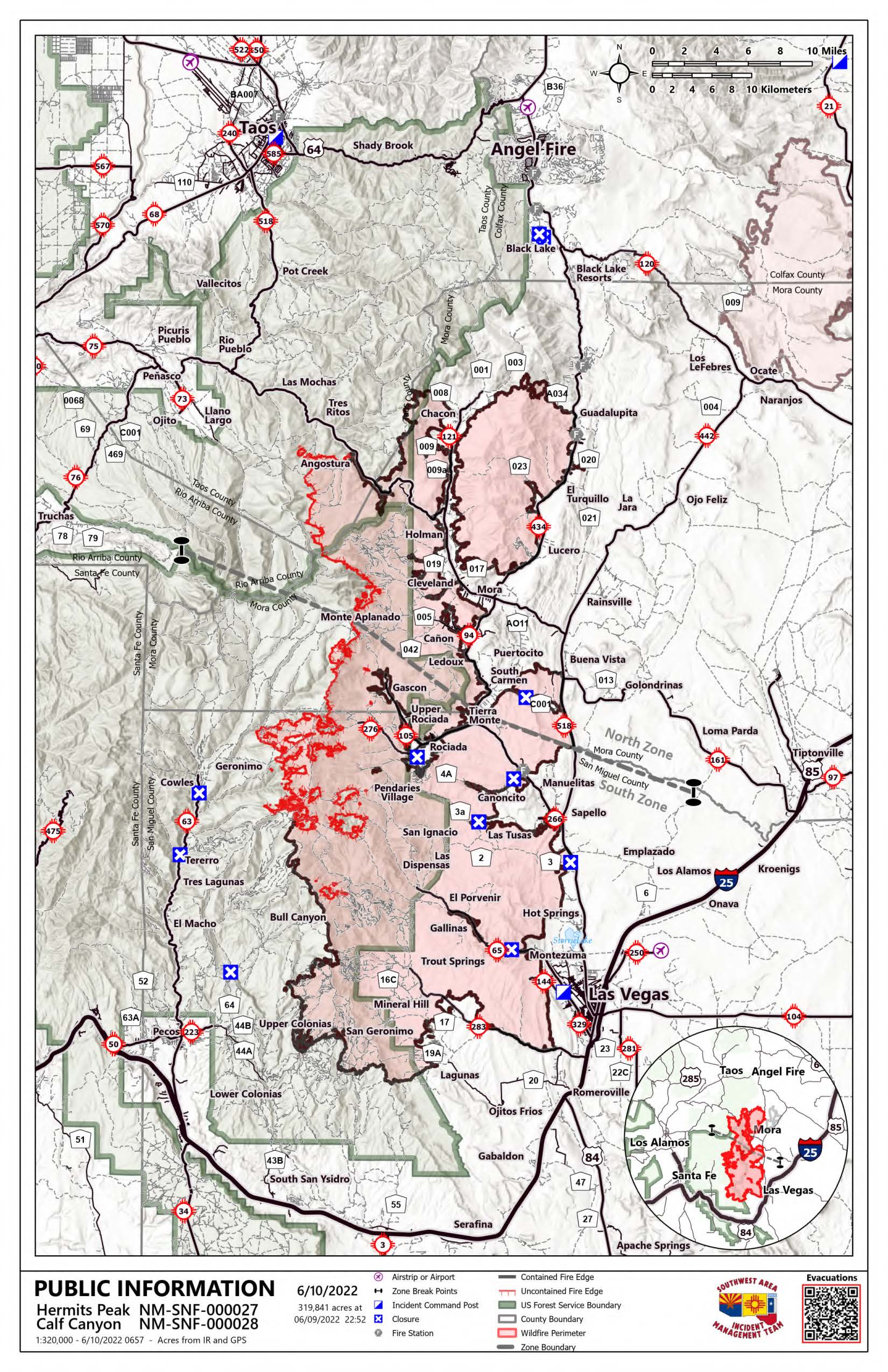
Hermits Peak and Calf Canyon Fire Daily Update for June 10 2022
Related Incident: Hermits Peak Fire
Publication Type: News
Hermits Peak and Calf Canyon Fires
June 10, 2022, Daily Update, 08:00 AM
Acres: 319,841 | Containment: 67% | Total personnel: 2,685 |
Start Date: Hermits Peak: April 6, 2022; Calf Canyon: April 19, 2022 | Cause: Hermits Peak: Spot fires from prescribed burn; Calf Canyon: Holdover fire from prescribed pile burn | Location: Located near Gallinas Canyon | Fuels: Heavy mixed conifer, ponderosa pine, brush, and grass
Highlights: Areas in "Set" evacuation status are open to residents only. Firefighters and heavy equipment are still working in these areas, and additional traffic from non-residents poses a hazard to fire personnel and the public. Please fill out the Private Property Suppression Repair Survey (https://tinyurl.com/suppressionrepair) if your property sustained damage from suppression activities. This information will assist fire officials and counties in evaluating properties and contacting owners.
Operations: North Zone (SWIMT1): Yesterday, crews were able to achieve more containment on the northern perimeter of the fire. The perimeter from Angostura to Martinez Pond has not shown any growth or heat in several days, and fire managers anticipate adding containment in that area in the coming days. A hotshot crew and wildland fire module have been mopping up interior pockets of heat from Ripley Point down to Serpent Lake to ensure that no embers threaten the firelines on the west. Work continues today on the shaded fuelbreak north of the fire area. Feller-bunchers are selectively thinning trees between NM Highway 64 and the Luna Fire burn scar, completing approximately ½ mile every day. Similar work is happening to connect the line from the Luna Fire burn scar to the Pot Creek area near NM Highway 518, with the heavy equipment completing approximately one mile every day. Suppression repair crews continue to focus on the east side of the fire, repairing dozer and hand line constructed during active suppression. Crews and excavators are breaking down dirt berms, naturalizing firelines and placing woody debris over the newly repaired lines to minimize erosion. Firefighters will also continue chipping small-diameter trees and branches to eliminate any large accumulations of roadside woody debris.
South Zone (SWIMT2): Scattered showers over the fire yesterday helped minimize fire movement. However, the fire will become more active over the next few days as winds increase, temperatures rise and humidity drops. Yesterday the fire was most active in the Trampas Fire (2022) burn scar moving into Mora Flats. Water drops were made by helicopters early in the day, but afternoon storms grounded air operations. Air resources will continue with water drops to cool and slow the fire's edge as weather allows. Control lines are in place, and hoses are laid along the line and primed with water should they be needed. A wildland fire module specializing in wilderness firefighting remains at Beatty's Cabin to monitor the fire and act if necessary. Around Upper and Lower Colonias and Barillas Peak, crews are chipping and spreading slash and evaluating other suppression repair needs. Crews remain in the Mineral Hills area doing repair work and are finishing up repair activities on the east perimeter.
Closures and Restrictions: All National Forests in New Mexico have closures or restrictions in place due to extreme fire danger. To learn more about these closures and restrictions, visit: https://tinyurl.com/bdy5y99r. Information related to fire restrictions across public and private land can be found at: https://nmfireinfo.com/fire-restrictions/.
Online: https://www.facebook.com/CalfCanyonHermitsPeak| nmfireinfo.com |tinyurl.com/HermitsYouTube | Santa Fe NF |
San Miguel County Sandbag Distribution Locations June 9 2022
Related Incident: Hermits Peak Fire
Publication Type: Announcement
FOR IMMEDIATE RELEASE: June 9, 2022 San Miguel/ Mora County
News Release Calf Canyon/ Hermits Peak Fire Sandbag Distribution Sites
Las Vegas – San Miguel County has established multiple Sandbag Distribution Sites for communities with potential risk of debris-flows and flooding. Tied sandbags operations are currently underway for residents to pick up at the following locations.
- Cabo Lucero Volunteer Fire Department - 21 County Rd A29
- Sapello-Rociada Volunteer Fire Department - 649 State Route 94 (N.M. 94)
- La Placita Volunteer Fire Department - 242 State Route 65 (N.M. 65)
- San Geronimo Volunteer Fire Department - County Road A19A (CR A19A)
- San Miguel County Public Works - 10 Airport Road
Sandbags is a simple, but effective way to prevent or reduce flood water damage. Properly filled and placed sandbags can act as a barrier to divert moving water around, instead of through, buildings. Sandbag construction does not guarantee a water-tight seal but is satisfactory for use in most situations. Sandbags are also used successfully to prevent overtopping of streams with levees, and for training current flows to specific areas