
Mora County FLASH FLOOD WARNING July 6 2022
Related Incident: Hermits Peak Fire
Publication Type: Announcement
FOR IMMEDIATE RELEASE July 6, 2022
FLASH FLOOD WARNING
MORA - The National Weather Service in Albuquerque has issued a Flash Flood Warning for the Hermits Peak and Calf Canyon Burn Scar in North Central Mora County in northeastern New Mexico until 5:45 PM, MDT.
PLEASE CLICK ON THE ATTACHED NEWS RELEASE FOR DETAILED INFORMATION.
Hermits Peak and Calf Canyon Fire Update July 6 2022
Related Incident: Hermits Peak Fire
Publication Type: News
Acres: 341,735 Containment: 93% Total Personnel: 556
Start Date: Hermits Peak: April 6, 2022; Calf Canyon: April 19, 2022 Cause: Hermits Peak: Spot fires from prescribed burn; Calf Canyon: Holdover fire from prescribed pile burn
Location: Located near Gallinas Canyon Fuels: Heavy mixed conifer, ponderosa pine, brush and grass
Highlights: On Wednesday, July 6 at 7:00 p.m., Transfer of Command for the north zone of the fire will occur from Southwest Area Incident Management Team 3, Incident Commander Lance Elmore to Great Basin Incident Management Team 7, Incident Commander Mike Johnston. The recording from last night’s community meeting is available on Facebook at: www.facebook.com/CalfCanyonHermitsPeak.
North Zone (SWIMT3): Firefighters are working in and around Angel Fire and Black Lake to remove fire equipment such as hoses and pumps and are repairing roads that were used during suppression. Firefighters are working with landowners to fix fences that were cut during suppression operations, chipping brush, repairing roads, and removing debris from roadways and waterways around Mora, Holman, Guadalupita, Chacon, along NM Highways 518 and 434 corridors, and other areas. Documentation is being created of suppression repairs needing to be done at a later time. Firefighters assigned to the incident are available to respond to any new fire starts within the fire area.
South Zone (GBIMT7): Resources on the west side had to leave the fire area mid-afternoon today due to weather. They continue to repair hand and dozer line as the weather allows. Excavators in the southern portion of the fire remain busy repairing dozer line. In the east, a 20-person hand crew along with overhead staff are continuing to work to scout, validate, and repair areas that have been identified through the ‘Suppression Repair Form.’ Personnel continue to scout areas across the fire and will work on repair when safe to access.
Closures and Restrictions: For the latest information about the Hermits Peak and Calf Canyon Fires closure orders for both the Santa Fe National Forest and Carson National Forest, please visit: https://tinyurl.com/bdy5y99r. Information related to fire restrictions across public and private land can be found at: https://nmfireinfo.com/fire-restrictions/.
Evacuations: For updated evacuation information from the Hermits Peak and Calf Canyon Fires, please visit: www.tinyurl.com/hermitspeak. The Ready, Set, Go evacuation guide in English and Spanish are available at: https://tinyurl.com/RSGNM. For disaster assistance resources, visit: https://www.nmdhsem.org/2022-wildfires/.
Weather: Drier air will begin to move into the area reducing the amount of available moisture over the next few days. This will result in lower chances for widespread precipitation, but isolated showers and thunderstorms remain possible each afternoon. The overall threat for widespread flooding and debris flow remains low but would increase greatly should a strong, slow-moving storm move over a high severity burn scar area.
After Fire Flooding and Recovery Resources: After Wildfire New Mexico guide: https://www.afterwildfirenm.org/| Hermits Peak & Calf Canyon Fire Burned Area Emergency Response information: https://inciweb.nwcg.gov/incident/8104/. New Mexico State EOC: 1-800-432 2080.
Suppression Repair Property Survey: https://www.tinyurl.com/suppressionrepair
Smoke: An interactive smoke map at fire.airnow.gov/ allows you to zoom into your area to see the latest smoke conditions.
Fire Information: Office Hours: 8:00 AM – 8:00 PM | Phone: 505-356-2636| Email: 2022.hermitspeak@firenet.gov
Online: inciweb.nwcg.gov/incident/8069/ | https://www.facebook.com/CalfCanyonHermitsPeak| nmfireinfo.com|tinyurl.com/HermitsYouTube | Santa Fe NF | Carson NF
Mora County FLASH FLOOD WARNING July 5 2022
Related Incident: Hermits Peak Fire
Publication Type: Announcement
FOR IMMEDIATE RELEASE: July 5, 2022
FLASH FLOOD WARNING
MORA - The National Weather Service in Albuquerque has issued a Flash Flood Warning for the Hermits Peak and Calf Canyon Burn Scar in northwestern Mora County in northeastern New Mexico until 5:45 PM, MDT.
PLEASE CLICK ON THE ATTACHED NEWS RELEASE FOR DETAILED INFORMATION
San MiguelMora County FLOOD ADVISORY 070522
Related Incident: Hermits Peak Fire
Publication Type: Announcement
For Immediate Release: July 5, 2022
Las Vegas - The National Weather Service in Albuquerque has issued a Flood Advisory for portions of north central and northeast New Mexico, including the following counties in north central New Mexico: Rio Arriba and Santa Fe. In northeast New Mexico: Mora and San Miguel.
PLEASE CLICK ON THE ATTACHED NEWS RELEASE FOR DETAILED INFORMATION
San Miguel Mora County FLASH FLOOD WARNING July 5 2022
Related Incident: Hermits Peak Fire
Publication Type: Announcement
San Miguel/ Mora County News Release Calf Canyon/ Hermits Peak Fire
Flash Flood Warning
At 1:35 PM MDT, Doppler radar indicated thunderstorms producing heavy rain over the Hermits Peak and Calf Canyon Burn Scar. Between 0.1 and 0.15 inches of rain have fallen. Additional rainfall amounts of 0.15 to 0.3 inches are possible in the warned area. Flash flooding is ongoing or expected to begin shortly.
HAZARD...Life threatening flash flooding. Thunderstorms producing flash flooding in and around the Hermits Peak and Calf Canyon Burn Scar.
IMPACT...Life threatening flash flooding of areas in and around the Hermits Peak and Calf Canyon Burn Scar. Las Vegas, El Porvenir, Montezuma, Sapello, Storrie Lake State Park, Tierra Monte, Romeroville, Gascon, Ledoux, Morphy Lake State Park, La Cueva, Tecolote, Gallinas, San Ignacio in Guadalupe County, Manuelitas, Mineral Hill, San Geronimo, Rociada, San Pablo and South Carmen.
The following highways may be impacted: State Road 94 between Mile Markers 1 and 18. State Road 266 between Mile Markers 0 and 6. State Road 276 between Mile Markers 0 and 5. State Road 518 between Mile Markers 1 and 26. Interstate 25 between Mile Markers 332 and 357. State
Road 283 between Mile Markers 1 and 12 and near Mile Marker 14. State Road 65 between Mile Markers 1 and 14. State Road 104 between Mile Markers 1 and 5. State Road 105 between Mile
Markers 0 and 9.
Please stay up to date by listening to local radio and television for further information. Local officials may call for evacuations in specific areas with the greatest risk.
James T. Murray, PIO jamest.murray@state.nm.us
Change in Hermits PeakCalf Canyon Fires Update Schedule July 5 2022
Related Incident: Hermits Peak Fire
Publication Type: News
Effective July 5, 2022 the Hermits Peak and Calf Canyon Fire Daily Updates will be released every other day. Therefore, the next Fire Update will be issued on July 6th and every other day thereafter.
Important announcements regarding time-sensitive information will continue to be posted in the ANNOUNCEMENTS section of INCIWEB, as soon as it is released for distribution.
Any changes to Closures will be posted in the CLOSURES section.
Updated PIO Maps are still being generated on a daily basis and they will continue to be available on INCIWEB, daily.SFNF Implements New Closure Order for Fire Area July 5 2022
Related Incident: Hermits Peak Fire
Publication Type: Closures
Santa Fe National Forest
Forest Service News Release
Media Contact: Julie Anne Overton
505-414-6438 (cell)
Santa Fe National Forest
11 Forest Lane, Santa Fe, NM 87508
Pecos Canyon and Gallinas Canyon Corridors Remain Closed
SANTA FE, NM – July 5, 2022 – A new closure order that goes into effect today at 8 a.m. reopens some areas on the west side of the Pecos/Las Vegas Ranger District that were closed under an earlier order, which terminates today, that restricted access to the entire district due to extreme fire danger. Monsoonal precipitation and additional containment of the Hermits Peak and Calf Canyon Fires have reduced the risk and allowed the Pecos/Las Vegas Ranger District to scale back the restricted area.
The always-popular Pecos Canyon corridor remains closed to hiking and camping under the new order, including all recreation sites from the Dalton Picnic Site north to Jacks Creek Campground, and there is no picnic or trailhead access within the canyon. Access to the Gallinas Canyon corridor is also off-limits.
Please do not plan to visit the following recreation sites:
· Jacks Creek, Iron Gate, Panchuela, Cowles, Holy Ghost, Field Tract, El Porvenir and EV Long Campgrounds
· Davis Willow and Dalton Dispersed Campgrounds
· Dalton, Oak Flats and Baker Flats Picnic Sites
The Hermits Peak and Calf Canyon flood risk closure protects public health and safety during wildfire suppression repair operations. Suppression repair includes hazard tree felling, road repair and stabilization, heavy equipment use and fire rehabilitation activities. The order also protects public health and safety in the event of potential post-fire impacts, including debris flow and flash flooding. The order will be in effect until it is rescinded or until Dec. 31, 2022, whichever comes earlier.
The closure order prohibits members of the public from entering the restricted area, including all Forest Service lands, roads and trails, within an area on the Pecos/Las Vegas Ranger District roughly defined by the southwestern edge of the forest boundary adjacent to the Village of Pecos, then following NM Route 63 north to Dalton Creek, following the creek northwest to the Pecos and Espanola District boundaries, then following the Pecos boundary north to the Pecos Wilderness, turning east and then north again to the junction of the Pecos Wilderness boundary and Beatty’s Trail 25, then following Trail 25 north to the Carson National Forest boundary and continuing northeasterly to the east boundary of the SFNF, then following the forest boundary south and then west back to the starting point at the Village of Pecos and NM Route 63.
Federal, state and local officers, firefighters and members of an organized rescue team, and any others authorized by Forest Service permit are exempt from the closure order. Violation of the closure order is a Class B misdemeanor punishable by a fine of not more than $5,000 for individuals and $10,000 for organizations, imprisonment of not more than six months, or both.
The closure order and map are posted on the SFNF website, and copies are available at SFNF headquarters
and the Pecos and Las Vegas Ranger Stations. For additional information, please contact the Pecos office at 505-757- 6121 or the Las Vegas office at 505-425-3534. All current closure orders are posted on the Alerts and Notices page of the website.
# # #
USDA is an equal opportunity provider, employer and lender.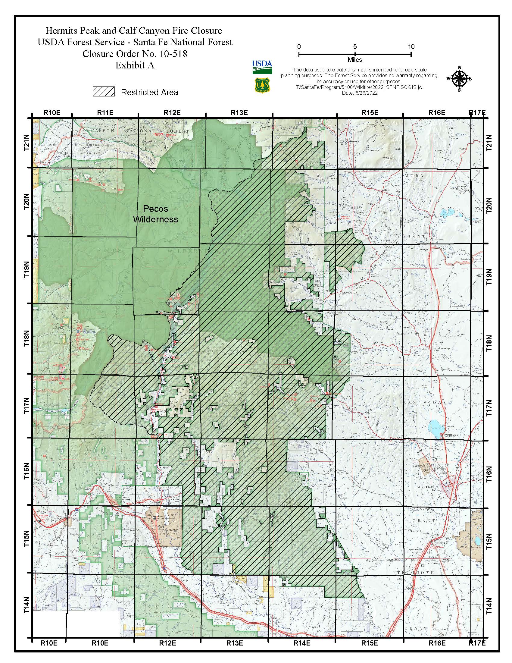
Reduction of Forest Closure Effective July 5 2022
Related Incident: Hermits Peak Fire
Publication Type: Closures
UNITED STATES DEPARTMENT OF AGRICULTURE FOREST SERVICE
CARSON NATIONAL FOREST CAMINO REAL RANGER DISTRICT
Hermits Peak and Calf Canyon Fire Closure
PROHIBITIONS
Pursuant to 16 U.S.C. § 551 and 36 C.F.R. § 261.50(a) and (b), the following acts are prohibited on the road and within the area (“Restricted Area”) described in this Order and as depicted on the attached map, all within the Camino Real Ranger District, Carson National Forest:
1. Going into or being upon the Restricted Area. 36 C.F.R. § § 261.52(e) and 261.53(e).
2. Using a motor vehicle on the road. 36 C.F.R. § 261.54(a).
EXEMPTIONS
Pursuant to 36 C.F.R. § 261.50(e), the following persons are exempt from this Order:
1. Persons with a written Forest Service authorization specifically exempting them from the effect of this Order.
2. Any Federal, State, or local officer, or member of an organized rescue or fire fighting force in the performance of an official duty.
3. Residents using roads in the Restricted Area to the extend necessary to access their private property.
RESTRICTED AREA AND ROAD DESCRIBED
As shown in the map at Exhibit A, the Restricted Area contains all National Forest System lands, roads and trails within the boundary starting at the intersection of the National Forest boundary and Highway 76, 1/2 miles south of Truchas, then following north along Highway 76 to the Forest boundary south of Chamisal, then following the Forest boundary southeast then north to where it reconnects with Highway 75, then following Highway 75 east then north to the intersection of State Road 518 at the Rock Wall, then from the Rock Wall following north along State Road 518 to its intersection with National Forest System Road (FR) 437, then following in a general northeastern direction along FR 437 to US Highway 64 near Valle Escondido (FR 437 is closed to motorized use but open for nonmotorized use only), then following US Highway 64 east to FR 5, then following FR 5 to the Forest boundary near Angel Fire, then following the Forest boundary from Angel Fire south to the State Road 518, then continuing to follow the Forest boundary west back to the point of beginning at the intersection of the Forest boundary and Highway 76, south of Truchas.
PURPOSE
The purpose of this Order is for wildfire suppression repair operations. These operations include but are not limited to hazard tree felling, road repair and stabilization, heavy equipment use and fire rehabilitation
efforts and to protect public health and safety in the event of debris flow and flash flooding in the Restricted Area.
IMPLEMENTATION
1. This Order will be effective on July 5, 2022, at 08:00 a.m.., and shall remain in effect until
August 31, 2022, or until rescinded, whichever occurs first.
2. A map identifying the Restricted Area, including the road restriction, is attached and made part of this Order as Exhibit A.
3. Any violation of the prohibitions in this Order is punishable as a Class B misdemeanor or by a fine of not more than $5,000.00 for individuals, and $10,000.00 for organizations and/or imprisonment for not more than six (6) months (see 16 U.S.C. § 551, 18 U.S.C. § 3571(b)(6), 18 U.S.C. § 3581(b)(7)).
4. Further information regarding this Order may be obtained at the Camino Real Ranger District located in Penasco, NM, telephone number 575-587-2255, and at the Carson National Forest Supervisor’s Office in Taos, NM, telephone number 575-758-6200.
5. This Order supersedes any previous Orders prohibiting the same acts covered by this Order.
Done at Taos, New Mexico this
29th
day of June, 2022.
Digitally signed by JAMES DURAN Date: 2022.06.29 07:22:43 -06'00'
JAMES D. DURAN
Forest Supervisor Carson National ForestHermits Peak and Calf Canyon Fires Daily Update 070422
Related Incident: Hermits Peak Fire
Publication Type: News
Location: Located near Gallinas Canyon
North Zone (SWIMT3): As weather conditions allow, firefighters continue with suppression operations by repairing fences, chipping brush, leveling parking areas used by fire vehicles and equipment, and removing debris from roadways and waterways around Mora, Holman, Guadalupita, Chacon, along NM Highways 518 and 434 corridors, and other areas. Firefighters are also creating documentation of needed repair information for future operations. Firefighters assigned to the incident are available to respond to any new fire starts within the north zone fire area. Fire resources will continue to be released from the incident due to the reduction in fire activity.
South Zone (GBIMT7): Minimal rain allowed for a productive day as resources on the west side of the fire continued to repair hand and dozer line. Excavators in the southern portion of the fire area remain busy repairing dozer line. In the east, a 20-person hand crew along with various other overhead positions are working to scout, validate, approve, and repair areas that have been identified through the ‘Suppression Repair Form.’ Personnel continue to scout areas across the fire and will work on repair when safe to access.
Evacuations: For updated evacuation information from the Hermits Peak and Calf Canyon Fires: www.tinyurl.com/hermitspeak. The Ready, Set, Go evacuation guide is available in English and Spanish here: https://tinyurl.com/RSGNM. For disaster assistance resources, visit: https://www.nmdhsem.org/2022-wildfires/.
Weather: Monsoonal moisture will remain in place over the area through much of the upcoming week, although to a lesser extent than in recent days. Isolated showers and thunderstorms are possible each day this week. The overall threat for widespread flooding and debris flow remains low, but would increase greatly should a strong, slow moving storm move over a high severity burn scar area.
Closures and Restrictions: The Hermits Peak and Calf Canyon Fires closure orders covering the Pecos/Las Vegas District of the Santa Fe National Forest and Camino Real Ranger District of the Carson National Forest remain in place. To learn more about these closures and restrictions, visit: https://tinyurl.com/bdy5y99r. Information related to fire restrictions across public and private land can be found at: https://nmfireinfo.com/fire-restrictions/.
After Fire Flooding and Recovery Resources: After Wildfire New Mexico guide: https://www.afterwildfirenm.org/| Hermits Peak & Calf Canyon Fire Burned Area Emergency Response information https://inciweb.nwcg.gov/incident/8104/. NM State EOC: 1-800-432 2080.
Suppression Repair Property Survey: https://www.tinyurl.com/suppressionrepair
Smoke: An interactive smoke map at fire.airnow.gov/ allows you to zoom into your area to see the latest smoke conditions.
Fire Information: Office Hours: 8:00 AM – 8:00 PM | Phone: 505-356-2636| Email: 2022.hermitspeak@firenet.gov
Online: inciweb.nwcg.gov/incident/8069/ | https://www.facebook.com/CalfCanyonHermitsPeak| nmfireinfo.com | tinyurl.com/HermitsYouTube | Santa Fe NF | Carson NF
Hermits Peak and Calf Canyon Fires Daily Update 070322
Related Incident: Hermits Peak Fire
Publication Type: News
North Zone (SWIMT3): Firefighters in the Pot Creek area continue constructing rolling dips on Forest Road 418 to prevent soil erosion. Suppression repair work, including chipping brush, repairing cut fences, leveling areas where equipment was parked, and constructing runoff water bars, continues around Mora, Holman, Guadalupita, Chacon, along NM Highways 518 and 434 corridors, and other areas. A repair group comprised of three hand crews, engines, and heavy equipment continue to clean debris from culverts and drainage ditches. Firefighters assigned to the incident are available to respond to any new fire starts within the north zone fire area.
South Zone (GBIMT7): Yesterday, crews were able to access and repair dozer line on the southwest corner of the fire. Excavators continue to repair and rehabilitate dozer line on the southern portion of the fire. Resources were able to repair dozer line near Chavez Trail. Weather is preventing access to the higher elevations. Due to current and predicted weather, fire managers are working to shift resources to the eastern portion of the fire to focus on suppression repair on private land.
Evacuations: For updated evacuation information from the Hermits Peak and Calf Canyon Fires: www.tinyurl.com/hermitspeak. The Ready, Set, Go evacuation guide is available in English and Spanish here: https://tinyurl.com/RSGNM. For disaster assistance resources, visit: https://www.nmdhsem.org/2022-wildfires/.
Weather: Monsoonal moisture will remain in place over the area through much of the upcoming week. The best opportunity for widespread showers and thunderstorms is today, but isolated to scattered showers and thunderstorms are possible each day. The overall threat for widespread flooding and debris flow will be low but increases significantly if a strong, slow-moving storm moves over a high-severity burn scar area.
Closures and Restrictions: The Hermits Peak and Calf Canyon Fires closure orders covering the Pecos/Las Vegas District of the Santa Fe National Forest and Camino Real Ranger District of the Carson National Forest remain in place. To learn more about these closures and restrictions, visit: https://tinyurl.com/bdy5y99r. Information related to fire restrictions across public and private land can be found at: https://nmfireinfo.com/fire-restrictions/.
After Fire Flooding and Recovery Resources: After Wildfire New Mexico guide: https://www.afterwildfirenm.org/| Hermits Peak & Calf Canyon Fire Burned Area Emergency Response information https://inciweb.nwcg.gov/incident/8104/.
Suppression Repair Property Survey: https://www.tinyurl.com/suppressionrepair
Smoke: An interactive smoke map at fire.airnow.gov/ allows you to zoom into your area to see the latest smoke conditions.
Fire Information: Office Hours: 8:00 AM – 8:00 PM | Phone: 505-356-2636| Email: 2022.hermitspeak@firenet.gov
Online: inciweb.nwcg.gov/incident/8069/ | https://www.facebook.com/CalfCanyonHermitsPeak| nmfireinfo.com