
Hermits Peak and Calf Canyon Fires Update July 8 2022
Related Incident: Calf Canyon
Publication Type: News
Acres: 341,735| Containment: 93% | Total personnel: 391| Start Date: Hermits Peak: April 6, 2022; Calf Canyon: April 19, 2022 | Cause: Hermits Peak: Spot fires from prescribed burn; Calf Canyon: Holdover fire from prescribed pile burn | Location: near Gallinas Canyon | Fuels: Heavy mixed conifer, ponderosa pine, brush, and grass
Highlights: The Hermits Peak and Calf Canyon Fires are no longer split into two zones and are now being managed as one fire by Great Basin Incident Management Team 7 under Incident Commander Mike Johnston.
Crews are working on the northern part of the fire cleaning ditches and repairing roads used during suppression. Work with landowners continues, fixing fences that were cut during suppression operations, chipping brush, repairing roads, and removing debris from roadways and waterways around Mora, Holman, Guadalupita, Chacon, and along NM Highways 518 and 434 corridors.
Resources continue to repair hand and dozer line on the west side of the fire. Excavators in the southern portion of the fire remain busy repairing dozer line. On the east side of the fire area, a 20‐person hand crew along with overhead staff are continuing to scout, validate, and repair areas that have been identified through the ‘Suppression Repair Form.’ Personnel continue to scout areas across the fire and will work on repair when safe to access. Personnel are also identifying suppression repairs which will be done at a later time.
Firefighters assigned to the incident are available to assist the local unit on any new fire starts in the area. Fire resources will continue to be released from the incident due to the reduction in fire activity.
Closures and Restrictions: Area closures remain in place for both the Santa Fe and Carson National Forests. These closures are in place for ongoing wildfire suppression repair operations and to protect public health and safety in the event of debris flow and flash flooding. The wildfire suppression repair operations include but are not limited to hazard tree felling, road repair and stabilization, heavy equipment use, and fire line repair efforts. For the latest information about the Hermits Peak and Calf Canyon Fires closure orders for both the Santa Fe National Forest and Carson National Forest, please see the links to each forest’s websites below. Information related to fire restrictions across public and private land can be found at: https://nmfireinfo.com/fire‐restrictions/.
Weather: A chance for moisture this weekend remains with a potential uptick on Saturday followed by a drier day on Sunday. Another surge of moisture will increase chances again next week. The overall threat for widespread flooding and debris flow remains low but would increase greatly should a strong, slow‐moving storm move over a high‐severity burn area.
After Fire Flooding and Recovery Resources: For disaster assistance resources: https://www.nmdhsem.org/2022‐ wildfires/| After Wildfire New Mexico guide: https://www.afterwildfirenm.org/| Hermits Peak & Calf Canyon Fire Burned Area Emergency Response information: https://inciweb.nwcg.gov/incident/8104/ |New Mexico State Emergency Operations Center: 1‐800‐432‐2080.
Suppression Repair Property Survey: https://www.tinyurl.com/suppressionrepair
Fire Information: Office Hours: 8:00 AM – 8:00 PM | Phone: 505‐356‐2636| Email: 2022.hermitspeak@firenet.gov
Online: inciweb.nwcg.gov/incident/8069/ | https://www.facebook.com/CalfCanyonHermitsPeak| nmfireinfo.com|tinyurl.com/HermitsYouTube | Santa Fe National Forest | Carson National Forest
San Miguel County FLASH FLOOD WARNING July 7 2022
Related Incident: Calf Canyon
Publication Type: Announcement
FOR IMMEDIATE RELEASE: July 7, 2022
FLASH FLOOD WARNING
LAS VEGAS - The National Weather Service in Albuquerque has issued a Flash Flood Warning for the Hermits Peak and Calf Canyon Burn Scar in San Miguel County in northeastern New Mexico until 4:00 PM, MDT.
PLEASE CLICK ON THIS LINK FOR THE SAN MIGUEL COUNTY SHERIFF’S OFFICE FACEBOOK PAGE FOR DETAILED INFORMATION
San Miguel Mora County News Release FLASH FLOOD WARNING 7622
Related Incident: Calf Canyon
Publication Type: Announcement
Las Vegas – The National Weather Service in Albuquerque has issued a Flash Flood Warning for The Hermits Peak and Calf Canyon Burn Scar in Mora County in northeastern New Mexico Northwestern San Miguel County in northeastern New Mexico Until 745 PM MDT.
PLEASE CLICK ON THE ATTACHED NEWS RELEASE FOR DETAILED INFORMATION.Mora County News Release FLASH FLOOD WARNING 762022
Related Incident: Calf Canyon
Publication Type: Announcement
MORA – The National Weather Service in Albuquerque has issued a Flash Flood Warning for the Hermits Peak and Calf Canyon Burn Scar in North Central Mora County in northeastern New Mexico until 545 PM MDT.
At 238 PM MDT, Doppler radar indicated thunderstorms producing heavy rain over the Cooks Peak Burn Scar. Between 0.25 and 0.75 inches of rain have fallen. Additional rainfall amounts of 0.25 to 1.00 inches are possible in the warned area. Flash flooding is ongoing or expected to begin shortly.
HAZARD...Life threatening flash flooding. Thunderstorms producing flash flooding in and around the Cooks Peak Burn Scar.
IMPACT... Thunderstorms producing flash flooding in and around the Cooks Peak Burn Scar. Some locations that will experience flash flooding include Ocate.
Please stay up to date by listening to local radio and television for further information. Local officials may call for evacuations in specific areas with the greatest risk.###
James T. Murray, PIO | jamest.murray@state.nm.usHermits Peak and Calf Canyon Fire Update July 6 2022
Related Incident: Calf Canyon
Publication Type: News
Acres: 341,735| Containment: 93% | Total personnel: 556| Start Date: Hermits Peak: April 6, 2022; Calf Canyon: April 19, 2022 | Cause: Hermits Peak: Spot fires from prescribed burn; Calf Canyon: Holdover fire from prescribed pile burn | Location: Located near Gallinas Canyon | Fuels: Heavy mixed conifer, ponderosa pine, brush, and grass
Highlights: On Wednesday, July 6 at 7:00 p.m., Transfer of Command for the north zone of the fire will occur from Southwest Area Incident Management Team 3, Incident Commander Lance Elmore to Great Basin Incident Management Team 7, Incident Commander Mike Johnston. The recording from last night’s community meeting is available on Facebook at: www.facebook.com/CalfCanyonHermitsPeak.
North Zone (SWIMT3): Firefighters are working in and around Angel Fire and Black Lake to remove fire equipment such as hoses and pumps and are repairing roads that were used during suppression. Firefighters are working with landowners to fix fences that were cut during suppression operations, chipping brush, repairing roads, and removing debris from roadways and waterways around Mora, Holman, Guadalupita, Chacon, along NM Highways 518 and 434 corridors, and other areas. Documentation is being created of suppression repairs needing to be done at a later time. Firefighters assigned to the incident are available to respond to any new fire starts within the fire area.
South Zone (GBIMT7): Resources on the west side had to leave the fire area mid-afternoon today due to weather. They continue to repair hand and dozer line as the weather allows. Excavators in the southern portion of the fire remain busy repairing dozer line. In the east, a 20-person hand crew along with overhead staff are continuing to work to scout, validate, and repair areas that have been identified through the ‘Suppression Repair Form.’ Personnel continue to scout areas across the fire and will work on repair when safe to access.
Closures and Restrictions: For the latest information about the Hermits Peak and Calf Canyon Fires closure orders for both the Santa Fe National Forest and Carson National Forest, please visit: https://tinyurl.com/bdy5y99r. Information related to fire restrictions across public and private land can be found at: https://nmfireinfo.com/fire-restrictions/.
Evacuations: For updated evacuation information from the Hermits Peak and Calf Canyon Fires, please visit: www.tinyurl.com/hermitspeak. The Ready, Set, Go evacuation guide in English and Spanish are available at: https://tinyurl.com/RSGNM. For disaster assistance resources, visit: https://www.nmdhsem.org/2022-wildfires/.
Weather: Drier air will begin to move into the area reducing the amount of available moisture over the next few days. This will result in lower chances for widespread precipitation, but isolated showers and thunderstorms remain possible each afternoon. The overall threat for widespread flooding and debris flow remains low but would increase greatly should a strong, slow-moving storm move over a high severity burn scar area.
After Fire Flooding and Recovery Resources: After Wildfire New Mexico guide: https://www.afterwildfirenm.org/| Hermits Peak & Calf Canyon Fire Burned Area Emergency Response information: https://inciweb.nwcg.gov/incident/8104/. New Mexico State EOC: 1-800-432 2080.
Suppression Repair Property Survey: https://www.tinyurl.com/suppressionrepair
Smoke: An interactive smoke map at fire.airnow.gov/ allows you to zoom into your area to see the latest smoke conditions.
Fire Information: Office Hours: 8:00 AM – 8:00 PM | Phone: 505-356-2636| Email: 2022.hermitspeak@firenet.gov
Online: inciweb.nwcg.gov/incident/8069/ | https://www.facebook.com/CalfCanyonHermitsPeak| nmfireinfo.com |tinyurl.com/HermitsYouTube | Santa Fe NF | Carson NFSFNF Implements New Closure Order for Fire Area July 5 2022
Related Incident: Calf Canyon
Publication Type: Closures
Santa Fe National Forest
Forest Service News Release
Santa Fe National Forest
11 Forest Lane, Santa Fe, NM 87508
Website | Facebook | Twitter
Media Contact: Julie Anne Overton
505-414-6438 (cell)
SM.FS.sfnfpao@usda.gov
Santa Fe National Forest
SANTA FE, NM – July 5, 2022 – A new closure order that goes into effect today at 8 a.m. reopens some areas on the west side of the Pecos/Las Vegas Ranger District that were closed under an earlier order, which terminates today, that restricted access to the entire district due to extreme fire danger. Monsoonal precipitation and additional containment of the Hermits Peak and Calf Canyon Fires have reduced the risk and allowed the Pecos/Las Vegas Ranger District to scale back the restricted area.
The always-popular Pecos Canyon corridor remains closed to hiking and camping under the new order, including all recreation sites from the Dalton Picnic Site north to Jacks Creek Campground, and there is no picnic or trailhead access within the canyon. Access to the Gallinas Canyon corridor is also off-limits.
Please do not plan to visit the following recreation sites:
· Jacks Creek, Iron Gate, Panchuela, Cowles, Holy Ghost, Field Tract, El Porvenir and EV Long Campgrounds
· Davis Willow and Dalton Dispersed Campgrounds
· Dalton, Oak Flats and Baker Flats Picnic Sites
The Hermits Peak and Calf Canyon flood risk closure protects public health and safety during wildfire suppression repair operations. Suppression repair includes hazard tree felling, road repair and stabilization, heavy equipment use and fire rehabilitation activities. The order also protects public health and safety in the event of potential post-fire impacts, including debris flow and flash flooding. The order will be in effect until it is rescinded or until Dec. 31, 2022, whichever comes earlier.
The closure order prohibits members of the public from entering the restricted area, including all Forest Service lands, roads and trails, within an area on the Pecos/Las Vegas Ranger District roughly defined by the southwestern edge of the forest boundary adjacent to the Village of Pecos, then following NM Route 63 north to Dalton Creek, following the creek northwest to the Pecos and Espanola District boundaries, then following the Pecos boundary north to the Pecos Wilderness, turning east and then north again to the junction of the Pecos Wilderness boundary and Beatty’s Trail 25, then following Trail 25 north to the Carson National Forest boundary and continuing northeasterly to the east boundary of the SFNF, then following the forest boundary south and then west back to the starting point at the Village of Pecos and NM Route 63.
Federal, state and local officers, firefighters and members of an organized rescue team, and any others authorized by Forest Service permit are exempt from the closure order. Violation of the closure order is a Class B misdemeanor punishable by a fine of not more than $5,000 for individuals and $10,000 for organizations, imprisonment of not more than six months, or both.
The closure order and map are posted on the SFNF website, and copies are available at SFNF headquarters and the Pecos and Las Vegas Ranger Stations. For additional information, please contact the Pecos office at 505-757- 6121 or the Las Vegas office at 505-425-3534. All current closure orders are posted on the Alerts and Notices page of the website.
# # #
USDA is an equal opportunity provider, employer and lender.
SFNF Implements New Closure Order for Hermits Peak and Calf Canyon Fire Area
Pecos Canyon and Gallinas Canyon Corridors Remain Closed
SANTA FE, NM – July 5, 2022 – A new closure order that goes into effect today at 8 a.m. reopens some areas on the west side of the Pecos/Las Vegas Ranger District that were closed under an earlier order, which terminates today, that restricted access to the entire district due to extreme fire danger. Monsoonal precipitation and additional containment of the Hermits Peak and Calf Canyon Fires have reduced the risk and allowed the Pecos/Las Vegas Ranger District to scale back the restricted area.
The always-popular Pecos Canyon corridor remains closed to hiking and camping under the new order, including all recreation sites from the Dalton Picnic Site north to Jacks Creek Campground, and there is no picnic or trailhead access within the canyon. Access to the Gallinas Canyon corridor is also off-limits.
Please do not plan to visit the following recreation sites:
· Jacks Creek, Iron Gate, Panchuela, Cowles, Holy Ghost, Field Tract, El Porvenir and EV Long Campgrounds
· Davis Willow and Dalton Dispersed Campgrounds
· Dalton, Oak Flats and Baker Flats Picnic Sites
The Hermits Peak and Calf Canyon flood risk closure protects public health and safety during wildfire suppression repair operations. Suppression repair includes hazard tree felling, road repair and stabilization, heavy equipment use and fire rehabilitation activities. The order also protects public health and safety in the event of potential post-fire impacts, including debris flow and flash flooding. The order will be in effect until it is rescinded or until Dec. 31, 2022, whichever comes earlier.
The closure order prohibits members of the public from entering the restricted area, including all Forest Service lands, roads and trails, within an area on the Pecos/Las Vegas Ranger District roughly defined by the southwestern edge of the forest boundary adjacent to the Village of Pecos, then following NM Route 63 north to Dalton Creek, following the creek northwest to the Pecos and Espanola District boundaries, then following the Pecos boundary north to the Pecos Wilderness, turning east and then north again to the junction of the Pecos Wilderness boundary and Beatty’s Trail 25, then following Trail 25 north to the Carson National Forest boundary and continuing northeasterly to the east boundary of the SFNF, then following the forest boundary south and then west back to the starting point at the Village of Pecos and NM Route 63.
Federal, state and local officers, firefighters and members of an organized rescue team, and any others authorized by Forest Service permit are exempt from the closure order. Violation of the closure order is a Class B misdemeanor punishable by a fine of not more than $5,000 for individuals and $10,000 for organizations, imprisonment of not more than six months, or both.
The closure order and map are posted on the SFNF website, and copies are available at SFNF headquarters
and the Pecos and Las Vegas Ranger Stations. For additional information, please contact the Pecos office at 505-757- 6121 or the Las Vegas office at 505-425-3534. All current closure orders are posted on the Alerts and Notices page of the website.
# # #
USDA is an equal opportunity provider, employer and lender.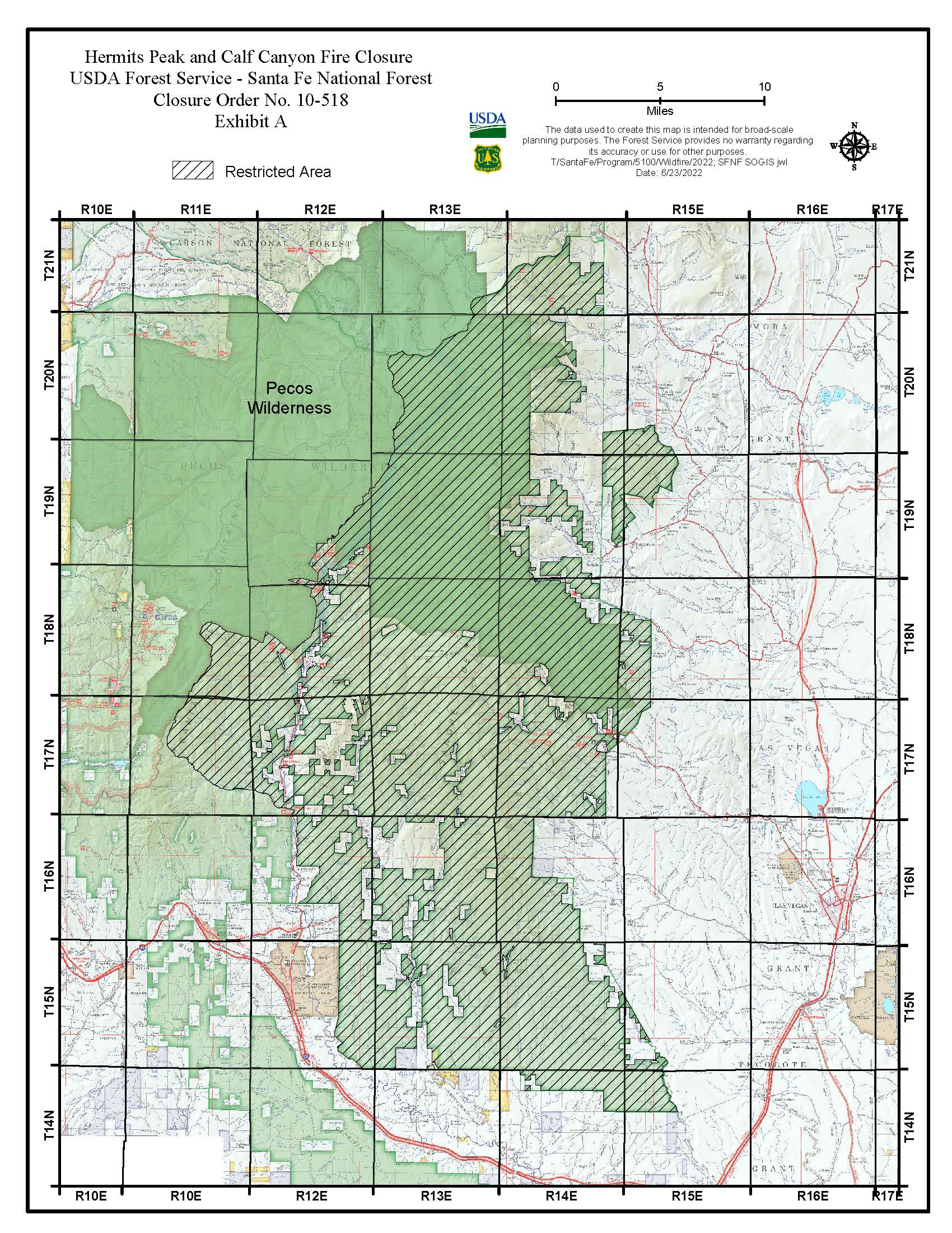
San Miguel Mora County FLOOD ADVISORY July 5 2022
Related Incident: Calf Canyon
Publication Type: Announcement
For Immediate Release: July 5, 2022
Las Vegas - The National Weather Service in Albuquerque has issued a Flood Advisory for portions of north central and northeast New Mexico, including the following counties in north central New Mexico: Rio Arriba and Santa Fe. In northeast New Mexico: Mora and San Miguel.
PLEASE CLICK ON THE ATTACHED NEWS RELEASE FOR DETAILED INFORMATION
San Miguel Mora County FLASH FLOOD WARNING July 5 2022
Related Incident: Calf Canyon
Publication Type: Announcement
FOR IMMEDIATE RELEASE: July 5, 2022
MORA – The National Weather Service in Albuquerque has issued a Flash Flood Warning for the Hermits Peak and Calf Canyon Burn Scar in Northwestern Mora County in northeastern New Mexico until 545 PM MDT.
At 248 PM MDT, Doppler radar indicated thunderstorms producing heavy rain over the Hermits Peak and Calf Canyon Burn Scar. Between 0.1 and 0.2 inches of rain have fallen. Additional rainfall amounts of 0.25 to 0.5 inches are possible in the warned area. Flash flooding is ongoing or expected to begin shortly.
Excessive rainfall over the burn scar will impact Manuelitas Creek, Sapello River, Rio San Jose, Santiago Creek, Rito Cebolla, Rio La Casa, Vigil Creek, Coyote Creek, Mora River, and La Canada del Carro. The debris flow can consist of rock, mud, vegetation, and other loose materials.
HAZARD...Life threatening flash flooding. Thunderstorms producing flash flooding in and around the Luna Burn Scar.
IMPACT... Life threatening flash flooding. Thunderstorms producing flash flooding in and around the Hermits Peak and Calf Canyon Burn Scar.
Some locations that will experience flash flooding include Mora, Holman, Cleveland, Chacon, El Turquillo, Luceros, Guadalupita and Rainsville.
This includes the following highways: State Road 283 near Mile Marker 13. State Road 518 between Mile Markers 27 and 47. State Road 434 between Mile Markers 0 and 14. State Road 121 between Mile Markers 0 and 8.
Please stay up to date by listening to local radio and television for further information. Local officials may call for evacuations in specific areas with the greatest risk.
###
James T. Murray, PIO | jamest.murray@state.nm.us |
San Miguel Mora County News ReleaseFlash Flood Warning July 5 2022
Related Incident: Calf Canyon
Publication Type: Announcement
San Miguel/ Mora County News Release Calf Canyon/ Hermits Peak Fire
Flash Flood Warning
Las Vegas – The National Weather Service in Albuquerque has issued a Flash Flood Warning for The Hermits Peak and Calf Canyon burn scar in Southwestern Mora County in northeastern New Mexico Northwestern San Miguel County in northeastern New Mexico until 430 PM MDT.
At 135 PM MDT, Doppler radar indicated thunderstorms producing heavy rain over the Hermits Peak and Calf Canyon Burn Scar. Between 0.1 and 0.15 inches of rain have fallen. Additional rainfall amounts of 0.15 to 0.3 inches are possible in the warned area. Flash flooding is ongoing or expected to begin shortly.
Excessive rainfall over the burn scar will impact Gallinas Creek and Gallinas River drainage area including Porvenir Canyon, Arroyo Pecos, Agua Zarca and Vegosa Creek. The debris flow can consist of rock, mud, vegetation, and other loose materials.
HAZARD...Life threatening flash flooding. Thunderstorms producing flash flooding in and around the Hermits Peak and Calf Canyon Burn Scar.
IMPACT...Life threatening flash flooding of areas in and around the Hermits Peak and Calf Canyon Burn Scar. Las Vegas, El Porvenir, Montezuma, Sapello, Storrie Lake State Park, Tierra Monte, Romeroville, Gascon, Ledoux, Morphy Lake State Park, La Cueva, Tecolote, Gallinas, San Ignacio in Guadalupe County, Manuelitas, Mineral Hill, San Geronimo, Rociada, San Pablo and South Carmen
The following highways may be impacted: State Road 94 between Mile Markers 1 and 18. State Road 266 between Mile Markers 0 and 6. State Road 276 between Mile Markers 0 and 5. State Road 518 between
Mile Markers 1 and 26. Interstate 25 between Mile Markers 332 and 357. State Road 283 between Mile
Markers 1 and 12 and near Mile Marker 14. State Road 65 between Mile Markers 1 and 14. State Road 104
between Mile Markers 1 and 5. State Road 105 between Mile Markers 0 and 9.
Please stay up to date by listening to local radio and television for further information. Local officials may call for evacuations in specific areas with the greatest risk.
###
James T. Murray, PIO | jamest.murray@state.nm.usChange in Hermits PeakCalf Canyon Fires Update Schedule July 5 2022
Related Incident: Calf Canyon
Publication Type: News
Effective July 5, 2022 the Hermits Peak and Calf Canyon Fire Daily Updates will be released every other day. Therefore, the next Fire Update will be issued on July 6th and every other day thereafter.
Important announcements regarding time-sensitive information will continue to be posted in the ANNOUNCEMENTS section of INCIWEB, as soon as it is released for distribution.
Any changes to Closures will be posted in the CLOSURES section.
Updated PIO Maps are still being generated on a daily basis and they will continue to be available on INCIWEB, daily.