
After Fire Flooding and Recovery Resources Guide for NM Communities
Related Incident: Nogal Canyon Post-Fire BAER
Publication Type: News
After Fire Flooding and Recovery Resources for NM Communities
After Wildfire New Mexico Guide for Communities: https://www.afterwildfirenm.org/ and also attached below as a PDF document under Related Information.
This guide is an interagency response to fire affected communities’ requests for a one-stop-shop for information to help them respond to wildfires.
In recent years, New Mexico experienced multiple catastrophic wildfires, many followed by intense flooding. In the wake of these events, communities had to navigate a complex system of state and federal response authorities.
This guide was created to help communities organize and respond to wildfire and subsequent flooding.
The guide contains safety information, flood information, state and federal agency resources and contacts for assistance, ways to mobilize your community, and financial and funding tips for communities and families.
It is intended to provide useful guidance through a difficult time, and to start you and your community on the road to recovery. If you are reading this before a wildfire occurs, use it to help you plan ahead.
BAER Safety PosterPotential Flood Hazards
Related Incident: Nogal Canyon Post-Fire BAER
Publication Type: News
BAER INFORMATION: FOR YOUR SAFETY – POTENTIAL FLOOD HAZARDS
IT IS IMPORTANT THAT RESIDENTS AND VISITORS TAKE STEPS TO PROTECT THEMSELVES AND THEIR PROPERTY FROM POTENTIAL FLOODING AND DEBRIS FLOWS:
§ Communities need to monitor local weather reports and public safety bulletins, local road closures, emergency notifications, weather alerts, follow local county and city advisories, and act accordingly.
§ Use a “weather radio” or smart phone “weather app” that monitors “all hazards” alerts issued by the NOAA-National Weather Service (http://www.nws.noaa.gov/nwr/).
§ Prepare for rainstorms by being prepared to evacuate if county or city emergency officials determine that flooding and debris flows are expected which could pose an increased threat to human life, safety, and property. Practice evacuations before real events occur.
§ Know and be alert to environmental signs of dangerous weather conditions and be prepared to take action that can save lives.
§ Understand that all drainages within and downstream of the burned area can produce flash flooding.
§ Flash floods can occur even though it is not raining where you are it may be raining hard further up-stream.
§ If you find yourself in a flood, climb to safety (seek higher ground).
§ Even if the water appears shallow enough to cross, don’t try it by vehicle or foot. Water hides dips in the road – worse yet, there may be no road left under the water as flooding can scour away the entire road surface and ground beneath the road.NOTE: See this information as a poster and flyer attached as PDF documents (ENGLISH & SPANISH) below at related information.
BAER BROCHURE Your Guide to Flood Preparation
Related Incident: Nogal Canyon Post-Fire BAER
Publication Type: News
BAER BROCHURE:
Your Guide to Flood Preparation
Preparing for Flood Waters after Wildfires
The emergency doesn’t end when the smoke clears!
Wildfires can significantly change the landscape, presenting risk of debris-flows and flooding. Change in vegetation, combined with steep slopes and intense rainfall, increase the risk of flash flooding in the burned area. Lands downstream of the burned area are also subject to increased flooding.
Until the burned area begins to recover, little will stop the waters from coming down the canyons. While multi-agency efforts are being taken to reduce the risks to life and property downstream of the fire, residents in the area should develop individual plans to protect themselves and their property.
Now is the time to prepare for post-fire flooding!
Preparing for Rain After NM Wildfires
Related Incident: Nogal Canyon Post-Fire BAER
Publication Type: News
New Mexico—Southwest Region
Preparing for Rain After Wildfires
BAER SAFETY MESSAGE: Everyone near and downstream from the burned areas should remain alert and stay updated on weather conditions that may result in heavy rains and increased water runoff. Flash flooding may occur quickly during heavy rain events-be prepared to act. Current weather and emergency notifications can be found at the National Weather Service website: https://www.weather.gov/abq/.
POST-FIRE WATERSHED CONDITIONS—KEY MESSAGES
While many wildfires cause minimal damage to the land and pose few threats to the land or people downstream, some fires cause damage that requires special efforts to prevent problems afterwards.
Summer monsoon thunderstorms and winter rain events in the southwest mountains can result in high water runoff and flooding.
Wildfire increases the potential for flooding, post-fire soil erosion and debris flows that could impact campgrounds, fishing areas, homes, structures, roads, and other infrastructure within, adjacent to, and downstream from the burned areas.
Post-fire, watershed conditions will naturally receive and transport water and sediment differently than during pre-fire conditions.
The public and communities adjacent to and downstream from the wildfire areas should expect increased flooding and debris transport during less than average rain events.
SAFETY CONCERNS CONTINUE AFTER THE FIRE IS OUT
The potential for increased water runoff and debris flows are not just a one-year concern.
We recognize the threat potential of flash floods and debris flows may exist for the next several years, depending on the intensity of these storms.
For life and safety concerns, burned area public land closures are sometimes implemented prior to forecast rain events until the burned area fully recovers.
Residents and visitors should remain alert to weather events and plan ahead when travelling along roads within and downstream from the burned areas.
ASSESSING BURNED WATERSHEDS RESPONSE
Forest Service Burned Area Emergency Response (BAER) teams work with each of the national forests, to assess the condition of the watersheds on National Forest System (NFS) lands burned by wildfires.
BAER assessment teams identify potential emergency threats to BAER critical values that may be considered at-risk on federal lands such as:
§ Human life and safety.
§ NFS property, such as buildings, water systems and infrastructure, utility systems, road and trail prisms.
§ Critical natural resources such as water, soil productivity and hydrologic function, areas where invasive species or noxious weeds may impact native or naturalized communities and may include critical habitat or suitable occupied habitat for federally listed threatened or endangered species.
§ Critical cultural and heritage resources such as pre-historic and historic properties and sites.
BAER assessment teams recommend emergency stabilization response actions that are implemented on federal land to reduce potential post-fire threats.
PREPARING FOR POTENTIAL FLOODING AND DEBRIS-FLOWS FROM WILDFIRE BURNED AREAS
For values and resources potentially impacted off federal lands, one of the most effective BAER strategies is interagency coordination with local cooperators who assist affected businesses, homes, and landowners with preparing for rain events.
While multi-agency efforts are being taken to reduce the risks to life and safety adjacent to and downstream from the burned areas, nearby residents should develop individual plans to protect themselves and their property.
The USDA Forest Service and the USDA Natural Resources Conservation Service (NRCS) work together and coordinate with other federal, state and local agencies, and counties that assist private landowners in preparing for increased water run-off and potential flooding impacts.
NRCS and local sponsors prepare damage survey reports for eligible sites on private lands adjacent to and downstream from affected areas. NRCS uses these reports, along with the Forest Service BAER team’s assessment report, to develop emergency measures to reduce the impacts from potential increased water and debris flows, and assist local sponsors to implement recommended emergency measures through its Emergency Watershed Protection (EWP) Program: (www.nrcs.usda.gov/Internet/FSE_DOCUMENTS/stelprdb1045263.pdf).
All EWP Program–Recovery projects begin with a local sponsor or legal subdivision of state or tribal government. Eligible sponsors include cities, counties, towns, conservation districts, or any federally recognized Native American tribe or tribal organization. Interested public and private landowners can apply for EWP Program–Recovery assistance through one of those sponsors. For more information on NRCS Disaster Assistance Programs: Emergency Watershed Protection Program | NRCS New Mexico (usda.gov).
The following links provide information and references for state and local county offices of emergency management promote preparedness through its emergency services programs to assist the public to prepare for, respond appropriately to, and quickly recover from natural emergencies that may impact county residents and visitors:
After Fire: Toolkit for the Southwest (postfiresw.info)
After Wildfire: A Guide for New Mexico Communities
New Mexico Fire Information: After a Wildfire
Department of Homeland Security and Emergency Management - Welcome to NewMexico.gov (nm.gov)
New Mexico Current Road Conditions
NM Counties Wildfire Risk Reduction Program
New Mexico County Office of Emergency Services
New Mexico Counties, NM County List - USA (officialusa.com)
Homes or businesses that could be impacted by flooding from federal land that resulted from wildfires may be eligible for flood insurance coverage from the National Flood Insurance Program (NFIP). Information about NFIP is available through FEMA at www.fema.gov/national-flood-insurance-program, or FEMA Wildfire Increases Flood Risk. Other flood preparedness information is available at www.ready.gov/floods and www.floodsmart.gov/.
LINKS TO ADDITIONAL RESOURCES AND WEBSITES
NRCS Emergency Watershed Protection Recovery Assistance
FEMA Wildfire Increases Flood Risk
FEMA Know Your Post-Wildfire Flooding Risk
FEMA Flood After Fire—Fact Sheet
Recovering from Wildfire-Damage Assessments
Be Ready & Prepare for Emergencies
NWS Weather Information—Albuquerque NM
NWS Post-Wildfire Flash Flood-Debris Flow Guide
NWS-North American Monsoon Awareness
NWS-North American Monsoon Flash Floods
NOAA Flood After Fire-Know Your Risk
NOTE: See this information BAER brief attached as a PDF document (ENGLISH & SPANISH) below at Related Information.PostFire Resources for NM Private Property Owners
Related Incident: Nogal Canyon Post-Fire BAER
Publication Type: News
Southwest Region – New Mexico
Post-Fire Resources for Private Property Owners
POST-FIRE WATERSHED CONDITIONS—KEY MESSAGES
While many wildfires cause minimal damage to the land and pose few threats to the land or people downstream, some fires cause damage that requires special efforts to prevent problems afterwards.
Summer monsoon thunderstorms and winter rain events in the southwest mountains can result in high water runoff and flooding.
Wildfire increases the potential for flooding, post-fire soil erosion and debris flows that could impact campgrounds, fishing areas, homes, structures, roads, and other infrastructure within, adjacent to, and downstream from the burned areas.
Post-fire, watershed conditions will naturally receive and transport water and sediment differently than during pre-fire conditions.
The public and communities adjacent to and downstream from the wildfire areas should expect increased flooding and debris transport during less than average rain events.
SAFETY CONCERNS CONTINUE AFTER THE FIRE IS OUT
The potential for increased water runoff and debris flows are not just a one-year concern.
We recognize the threat potential of flash floods and debris flows may exist for the next several years, depending on the intensity of these storms.
For life and safety concerns, burned area public land closures are sometimes implemented prior to forecast rain events until the burned area fully recovers.
Residents and visitors should remain alert to weather events and plan ahead when travelling along roads within and downstream from the burned areas.
ASSESSING BURNED WATERSHEDS RESPONSE
Forest Service Burned Area Emergency Response (BAER) teams work with each of the national forests, to assess the condition of the watersheds on National Forest System (NFS) lands burned by wildfires.
BAER assessment teams identify potential emergency threats to BAER critical values that may be considered at-risk on federal lands such as:
§ Human life and safety.
§ NFS property, such as buildings, water systems and infrastructure, utility systems, road and trail prisms.
§ Critical natural resources such as water, soil productivity and hydrologic function, areas where invasive species or noxious weeds may impact native or naturalized communities and may include critical habitat or suitable occupied habitat for federally listed threatened or endangered species.
§ Critical cultural and heritage resources such as pre-historic and historic properties and sites.
BAER assessment teams recommend emergency stabilization response actions that are implemented on federal land to reduce potential post-fire threats.
ASSISTANCE FOR PRIVATE LAND AND HOMEOWNERS ADJACENT TO AND DOWNSTREAM FROM BURNED AREAS
For values and resources potentially impacted off federal lands, one of the most effective BAER strategies is interagency coordination with local cooperators who assist affected businesses, homes, and landowners with preparing for rain events.
While multi-agency efforts are being taken to reduce the risks to life and safety adjacent to and downstream from the burned areas, nearby residents should develop individual plans to protect themselves and their property.
The USDA Forest Service and the USDA Natural Resources Conservation Service (NRCS) work together and coordinate with other federal, state and local agencies, and counties that assist private landowners in preparing for increased water run-off and potential flooding impacts.
NRCS and local sponsors prepare damage survey reports for eligible sites on private lands adjacent to and downstream from affected areas. NRCS uses these reports, along with the Forest Service BAER team’s assessment report, to develop emergency measures to reduce the impacts from potential increased water and debris flows, and assist local sponsors to implement recommended emergency measures through its Emergency Watershed Protection (EWP) Program: (www.nrcs.usda.gov/Internet/FSE_DOCUMENTS/stelprdb1045263.pdf).
All EWP Program–Recovery projects begin with a local sponsor or legal subdivision of state or tribal government. Eligible sponsors include cities, counties, towns, conservation districts, or any federally-recognized Native American tribe or tribal organization. Interested public and private landowners can apply for EWP Program–Recovery assistance through one of those sponsors. For more information on NRCS Disaster Assistance Programs: Emergency Watershed Protection Program | NRCS New Mexico (usda.gov).
The following links provide information and references for state and local county offices of emergency management promote preparedness through its emergency services programs to assist the public to prepare for, respond appropriately to, and quickly recover from natural emergencies that may impact county residents and visitors:
After Fire: Toolkit for the Southwest (postfiresw.info)
After Wildfire: A Guide for New Mexico Communities
New Mexico Fire Information: After a Wildfire
Department of Homeland Security and Emergency Management - Welcome to NewMexico.gov (nm.gov)
New Mexico Current Road Conditions
NM Counties Wildfire Risk Reduction Program
New Mexico County Office of Emergency Services
New Mexico Counties, NM County List - USA (officialusa.com)
Homes or businesses that could be impacted by flooding from federal land that resulted from wildfires may be eligible for flood insurance coverage from the National Flood Insurance Program (NFIP). Information about NFIP is available through FEMA at www.fema.gov/national-flood-insurance-program, or FEMA Wildfire Increases Flood Risk. Other flood preparedness information is available at www.ready.gov/floods and www.floodsmart.gov/.
LINKS TO ADDITIONAL RESOURCES AND WEBSITES
NRCS Emergency Watershed Protection Recovery Assistance
FEMA Wildfire Increases Flood Risk
FEMA Flood After Fire—Fact Sheet
Recovering from Wildfire-Damage Assessments
After Disaster Guidebook Template - Emergency Management - CSU Extension (colostate.edu)
Boulder-County-After-the-Disaster-Guidebook-CSU-Extension-V4.pdf (colostate.edu)
Be Ready & Prepare for Emergencies
NWS Weather Information—Albuquerque NM
NWS Post-Wildfire Flash Flood-Debris Flow GuideNogal Canyon PostFire BAER Assessment Summary Released
Related Incident: Nogal Canyon Post-Fire BAER
Publication Type: Announcement
NOGAL CANYON POST-FIRE BAER ASSESSMENT SUMMARY RELEASED

Top of Nogal Canyon
The Forest Service, Lincoln National Forest has released a summary of its post-fire assessment for emergency stabilization measures and actions on National Forest System (NFS) lands burned by the Nogal Canyon Fire. The emergency treatments and activities are designed to decrease possible impacts to critical values from the burned area such as: life and safety, property, critical natural resources, and cultural resources.
The Nogal Canyon Fire began on April 12, 2022, burning 6 primary residences and 8 outbuildings approximately 12 miles west of Capitan, New Mexico. The cause of the fire was determined to be a downed power lines. The fire grew to approximately 420 acres and burned primarily in Nogal Canyon, the bottom and steep slopes outside of the White Mountain Wilderness. The fire burned in grassland, Juniper grassland, Pinyon-Juniper woodland, Interior Chaparral, mixed Conifer and Ponderosa Pine forest. Of the 420 acres burned, 371 acres were National Forest System (NFS) lands and the remaining acres were private lands.
Core team members of the Burned Area Emergency Response (BAER) assessment team deployed into the field on April 23, 2022. The team consisted of specialists in soils, hydrology, wildlife, biology, roads, recreation, botany, weeds, cultural resources, geographic information systems (GIS), and public information (PIO).
The BAER assessment team’s emergency stabilization objectives for the Nogal Canyon burned area are to protect, mitigate and reduce the potential for identified post-fire threats, including potential increased soil erosion/sediment yield and water runoff on steep slopes, to: 1) downstream human life and safety, and property; 2) Forest Service infrastructure and investments such as roads and trails; 3) critical natural resources; and 4) native and naturalized plant communities from new noxious weed infestations.
In addition to on-Forest efforts to reduce the threats to National Forest resources, the BAER team and the Lincoln National Forest warn users of Forest Service roads and trails of hazards present in the burned area.
The BAER team and Lincoln National Forest continues to communicate and coordinate with other agencies such as the National Resource Conservation Service (NRCS), NOAA National Weather Service, state agencies, and counties to assist private entities and communities including private residents, domestic water suppliers and public utilities to achieve post-fire recovery objectives.
The BAER team’s assessment report which includes the BAER assessment team’s analysis of the burned areas within the Nogal Canyon and recommended emergency treatments, was recently submitted to the Southwest Region (Region 3) Regional Forester by the Forest Supervisor for the Lincoln National Forest.
A copy of the Nogal Canyon post-fire BAER assessment executive summary can be accessed as a linked PDF document below under the Related Information Header.
BAER SAFETY MESSAGE: Everyone near and downstream from the burned areas should remain alert and stay updated on weather conditions that may result in heavy rains and increased water runoff. Flash flooding may occur quickly during heavy rain events-be prepared to act. Current weather and emergency notifications can be found at the National Weather Service website: https://www.weather.gov/abq/.USGS PostFire DebrisFlow Hazard Assessment Map for Nogal Canyon Fire
Related Incident: Nogal Canyon Post-Fire BAER
Publication Type: News
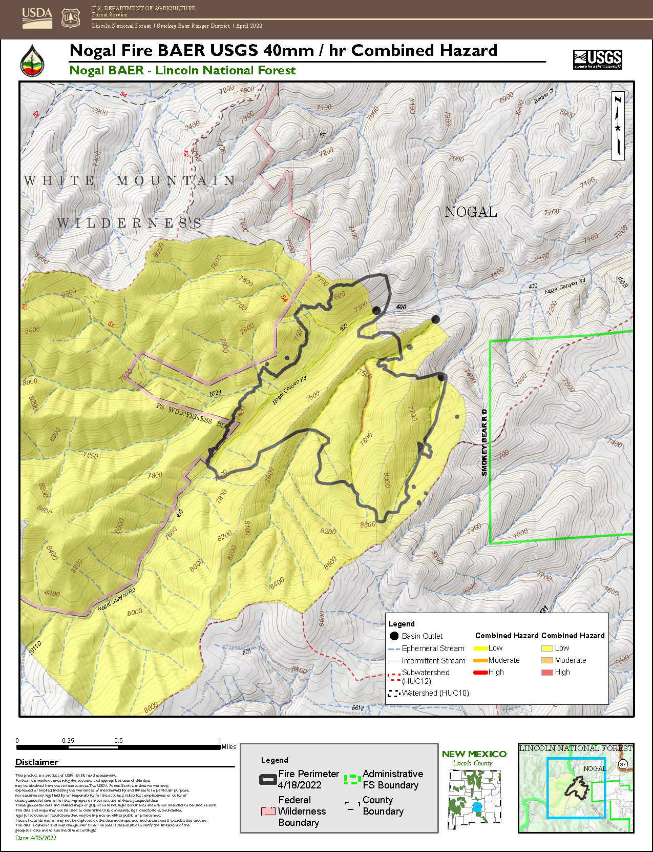
USGS Post-Fire Debris-Flow Hazard Assessment Map Completed for Nogal Canyon Fire
The Nogal Canyon Post-Fire Burned Area Emergency Response (BAER) assessment team coordinated with the US Geological Survey (USGS) during its evaluation of the burned area to assess potential post-fire hazards, including debris flows.
USGS utilized the BAER team’s soil burn severity (SBS) map to model potential debris flow hazards within the burned area. The data estimates debris-flow likelihood, volume, combined hazard, and rainfall thresholds and are presented in the debris flow map (see below). The combined relative hazard metric is a combination of the likelihood of debris flow (in %) and potential volume of debris flow (in m3).
The map depicts the likelihood of debris-flow generation and estimates of flow magnitude in locations where debris flows initiate. The models do not predict downstream impacts, potential debris-flow runout paths, or the spatial extent of debris-flow or flood inundation.
This information is extremely important to inform our safety awareness of the burned areas, especially where there may be an increased risk of hillslope erosion, flooding sediment delivery to streams, and a higher probability of debris flows – all of which are potential risks to human life, safety, and property.
For information on what to do if you live in a recently-burned area where debris flows are possible, and there is a rainstorm - before, during, and after, download the National Weather Service Post Wildfire Flash Flood and Debris Flow Guide (PDF 7.2 MB).
For additional information about the USGS emergency assessment of post-fire debris-flow hazards, go to: Emergency Assessment of Post-Fire Debris-Flow Hazards (usgs.gov).
Additional scientific information about the USGS debris-flow hazard report and analysis for the Nogal Canyon Fire:
USGS models estimate a low-level debris-flow hazard for most of the area burned by the Nogal Canyon Fire. All of the stream reaches and small drainage basins have a less than 20% likelihood of debris-flow occurrence at the modeled rainfall intensity. All of the burn area requires rainfall rates between greater than 40 mm/h to exceed a 50% likelihood of debris-flow occurrence. The two larger modeled watersheds are estimated to produce volumes between 10,000-100,000 m3. One smaller watershed in the eastern portion of the burn area is estimated to produce 3. The combined debris-flow hazard is low for the entire burn area. The year 1 and 2 model-estimated rainfall thresholds (segment-scale) and corresponding return intervals are as follows:
YEAR 1:
15-minute: 68 mm/h, or 0.7 inches in 15 minutes, RI = 1.4 years
30-minute: 48 mm/h, or 0.95 inches in 30 minutes, RI = 1.6 years
60-minute: 48 mm/h, or 1.9 inches in 60 minutes, RI = 8.2 years
YEAR 2:
15-minute: 89 mm/h, or 0.9 inches in 15 minutes, RI = 3.2 years
30-minute: 62 mm/h, or 1.25 inches in 30 minutes, RI = 3.7 years
60-minute: 64 mm/h, or 2.55 inches in 60 minutes, RI = 32.2 years
BAER SAFETY MESSAGE: Everyone near and downstream from the burned areas should remain alert and stay updated on weather conditions that may result in heavy rains and increased water runoff. Flash flooding may occur quickly during heavy rain events be prepared to act. Current weather and emergency notifications can be found at the National Weather Service website: www.weather.gov/abq/.

Burned Area Emergency Response BAER Limitations
Related Incident: Nogal Canyon Post-Fire BAER
Publication Type: News
Burned Area Emergency Response (BAER) Limitations
While many wildfires cause minimal damage to the land and pose few threats to the land or people downstream, some fires result in damage that requires special efforts to reduce impacts afterwards. Loss of vegetation exposes soil to erosion; water run-off may increase and cause flooding, soil and rock may move downstream and damage property or fill reservoirs putting community water supplies and endangered species at-risk.
The Burned Area Emergency Response (BAER) program is designed to identify and manage potential risks to resources on National Forest System lands and reduce these threats through appropriate emergency measures to protect human life and safety, property, and critical natural or cultural resources. BAER is an emergency program for stabilization work that involves time-critical activities to be completed before the first damaging storm event to meet program objectives.
BAER Objectives:
- Determine whether imminent post-wildfire threats to human life and safety, property, and critical natural or cultural resources on National Forest System lands exist and take immediate actions, as appropriate, to manage the unacceptable risks.
- If emergency conditions are identified, mitigate significant threats to human life and safety, Forest Service property and other critical natural and cultural resource values.
- Prescribe emergency response actions to stabilize and prevent unacceptable degradation to natural and cultural resources, to minimize threats to life or property resulting from the effects of a fire, or to repair/replace/construct physical improvements necessary to prevent degradation of land or resources.
- Implement emergency response actions to help stabilize soil; control water, sediment and debris movement and potentially reduce threats to the BAER critical values identified above when an analysis shows that planned actions are likely to reduce risks substantially within the first year following containment of the fire.
- Monitor the implementation and effectiveness of emergency treatments that were applied on National Forest System lands.
BAER Interagency Coordination:
Post-fire emergency response is a shared responsibility. There are several Federal, State and local agencies that have emergency response responsibilities or authorities in the post-fire environment. The BAER team coordinates with these agencies to look at the full scope and scale of the situation to reduce the potential threats to human life and property. It is important that BAER efforts are communicated with all affected and interested cooperating agencies and organizations regarding other post-fire recovery and restoration efforts.
BAER treatments cannot prevent all of the potential flooding or soil erosion impacts, especially after a wildfire-changed landscape. It is important for the public to stay informed and prepared for potentially dramatic increased run-off events.
One of the most effective BAER strategies is interagency coordination to provide post-fire threat information to local cooperators who can assist affected businesses, homes, and landowners to prepare for rain events. For example, the Natural Resources Conservation Service (NRCS) has the Emergency Watershed Protection (EWP) program for post-emergency assistance on private and tribal land, the National Weather Service (NWS) has responsibility for flood warning alerts, the Federal Emergency Management Agency (FEMA) has flood insurance and other responsibilities if the area is a Presidentially-declared emergency, Resource Conservation Districts (RCD) and counties, as well as State and local-highway and emergency services departments, Flood Control authorities, etc. It is important that landowners work directly with NRCS and other agencies to determine appropriate actions needed to protect private structures and other assets.
BAER Process:
BAER assessment teams are staffed by specially trained professionals that may include: hydrologists, soil scientists, engineers, biologists, botanists, archeologists, and others who evaluate the burned area and prescribe temporary emergency stabilization actions on National Forest System lands to protect the land quickly and effectively. BAER assessments usually begin before a wildfire has been fully contained.
A BAER assessment team conducts field surveys and uses science-based models to rapidly evaluate and assess the burned area and prescribe emergency stabilization measures. The team generates a “Soil Burn Severity” map by using satellite imagery which is then validated and adjusted by BAER team field surveys to assess watershed conditions and model potential watershed response from the wildfire. The map identifies areas of soil burn severity by categories of very low/unburned, low, moderate, and high which may correspond to a projected increase in watershed response. The higher the burn severity, the less the soil will be able to absorb water when it rains. Without absorption, there will be increased run-off with the potential of flooding.
The BAER team presents these findings in an assessment report that identifies immediate and emergency actions needed to address post-fire risks to human life and safety, property, cultural and critical natural resources. This includes early detection and rapid response (EDRR) treatments to prevent the spread of noxious weeds into native plant communities. The BAER report describes watershed pre- and post-fire watershed response information, areas of concern for life and property, and recommended short-term emergency stabilization measures for Forest Service lands that burned.
In most cases, only a portion of the burned area is actually treated. Severely burned areas steep slopes, and places where water run-off will be excessive and may impact important resources, are focus areas and described in the BAER assessment report if they affect critical values. Response action timing is essential to ensure the emergency stabilization measures are effective.
There are a variety of emergency stabilization actions that the BAER team can recommend for Forest Service land such as mulching with agricultural straw or chipped wood to protect soil productivity, increasing road drainage to keep roads and bridges from washing-out during post-fire floods, and early detection rapid response invasive plant treatments to prevent spread of weeds into native plant communities. BAER treatments are preventative in nature but cannot prevent all damage, especially debris torrents in areas that are prone to sliding and have lost critical root structure from plants.
The Cans and Cannots of BAER:
What BAER Can Do:
- Install water or erosion control devices
- Seed or mulch for erosion control or stability reasons
- Install erosion control measures at critical cultural sites
- Install temporary barriers to protect treated or recovering areas
- Install warning signs
- Replace minor safety related facilities, like burned guard rails
- Install appropriate-sized drainage features on roads, trails
- Remove critical safety hazards
- Prevent permanent loss of T&E habitat
- Monitor BAER treatments
- Implement EDRR treatments to minimize the spread of noxious weeds into native plant communities
What BAER Cannot Do:
- Prevent all flooding and debris flows
- Replant commercial forests or grass for forage
- Excavate and interpret cultural sites
- Replace burned pasture fences
- Install interpretive signs
- Replace burned buildings, bridges, corrals, etc.
- Repair roads damaged by floods after fire
- Remove all hazard trees
- Replace burned habitat
- Monitor fire effects
- Treat pre-existing noxious weeds
BAER Funding:
Special Emergency Wildfire Suppression funds are authorized for BAER activities and the amount of these expenses varies with the severity of the fire season. Some years see little BAER activity while other years are extremely busy.
Because of the emergency nature of BAER, initial requests for funding of proposed BAER treatments are supposed to be submitted by the Forest Supervisor to the Regional Office within7 days of total containment of the fire. The Regional Forester’s approval authority for individual BAER projects is limited. Approval for BAER projects exceeding this limit is forwarded onto the Washington Office.
BAER SAFETY MESSAGE: Everyone near and downstream from the burned areas should remain alert and stay updated on weather conditions that may result in heavy rains and increased water runoff. Flash flooding may occur quickly during heavy rain events be prepared to act. Current weather and emergency notifications can be found at the National Weather Service website: www.weather.gov/abq/.Nogal Canyon PostFire BAER Soil Burn Severity Map Released
Related Incident: Nogal Canyon Post-Fire BAER
Publication Type: Announcement
NOGAL CANYON POST-FIRE BAER SOIL BURN SEVERITY MAP RELEASED

USDA Forest Service Burned Area Emergency Response (BAER) is a multi-disciplinary team that assesses post-fire impacts on federal lands following significant wildfires. The role of the assessment team is to characterize fire effects within the burned area to identify imminent post-fire threats to human life, safety, property, infrastructure, and critical natural and cultural resources on NFS lands and recommend emergency response actions designed to mitigate identified risks.
The Nogal Canyon BAER assessment team coordinated early with other local and federal agencies such as county and state officials, Natural Resources Conservation Service (NRCS), National Weather Service (NWS), and USDOI Geological Service (USGS) to share information about burned watershed conditions and their predicted response during certain rain events.
After the team’s assessment of the Nogal Canyon burned area, Lincoln National Forest land managers will establish a separate BAER Implementation team to implement the protective and stabilization treatments that have been approved by the Forest Service Regional and National offices.
The team began their assessment immediately after the fire threat passed. Their focus was on direct effects to the burned landscape caused by the fire, rather than from fire suppression activities which are the responsibility of the Incident Management Team assigned to the fire. Post-fire effects such as loss of vegetation and change in soil stability commonly increase the likelihood of threats that include accelerated soil erosion, increased sediment delivery, flooding and debris flows.
BAER specialists recently completed their field data evaluation to produce the Soil Burn Severity (SBS) map for the approximately 419-acre Nogal Canyon Fire (number of acres analyzed by the BAER team on April 23, 2022—total number of acres may have changed since that date). The map and the data delineate Unburned, Low, and Moderate SBS categories. The BAER team assessing the Nogal Canyon Fire determined that no acres were identified as having high SBS conditions. Across the Nogal Canyon burned area, approximately 91% of the fire is either Unburned and/or Low SBS, while 9% sustained a Moderate SBS.
It is important to note the SBS map product is an estimate of fire effects on soils and not direct effects to vegetation. SBS characterizes the soil surface and below-ground impact, whereas effects on vegetation are estimates of mortality based primarily on changes in vegetation canopy. Changes in overhead and understory vegetation canopy are often used as initial indicators of overall burn severity, but do not necessarily coincide with SBS.
Changes in soil cover, water repellency, and soil physical/biological conditions guide the interpretations to determine the severity burn level of the soil. Water repellency can occur naturally in soils and it changes as a function of fire. It is frequently discussed as a post-fire effect. Fire can increase the strength and thickness (or depth) of water repellent layers in soil, considerably affecting post-fire water runoff and possibly extending time for recovery of the burned area.
Low SBS occurs from partial consumption of fine fuels where broken limbs, leaves and ground cover are relatively unchanged and intact on the soil surface. Burning at the soil surface was short in time and discontinuous, leaving root systems and soil physical and biological conditions undamaged. Based on the ecological community, burned vegetation will generally recover to pre-fire conditions within 1-to-2 years. Low SBS generally indicates a low to very low risk. Lower risk for accelerated runoff, erosion, flooding, and debris flows within and below these areas compared to moderate and high SBS areas.
Moderate SBS occurs where 50 to 80 percent of pre-fire soil cover (litter and ground fuels) was consumed by fire. Charring of the mineral soil is patchy or sporadic and plant roots within the soil may be scorched but are rarely consumed. Water repellency is often found at the surface, sometimes increasing in strength and depth which reduces the ability of precipitation to infiltrate the soil surface. The extent of scorched leaves on trees and shrubs is limited to riparian areas and some high elevation hillslopes. Shrub canopy removed by fire in moderate and high SBS areas varies and can reflect a range in mortality from high to low, which is why a closer look at the ground is required to determine the SBS level. Unburned leaves from fire-damaged or killed trees will provide ground cover to replace the organic soil cover that was consumed by the fire. Where greater amounts of reduced soil cover and increased water repellency occur, increased overland flow of water from precipitation is expected, most notably in locations where the overstory canopy no longer exists. Canopy only exists in several of the low and moderate SBS mainstem channel riparian areas. Recovery of burned understory vegetation in these areas can take 3-to-5 years thereby. increasing the short-term potential for post-fire threats.
For the Nogal Canyon burned area, no acres were identified by the BAER team to be high SBS which is typically the result of high-fire severity that corresponds with longer burning time at the soil surface. As a result of the high, longer duration heat nearly all the pre-fire soil cover and ground fuels have been consumed. The surface mineral soil structure can be reduced to powder (single grain) sometimes several inches thick with a continuous cover of white or gray ash. The fine and small roots of shrubs and grasses tend to be completely consumed. Water repellency does not exist at the surface because the organic materials have been vaporized and forced downward into pore spaces and voids between soil particles below the damaged soil surface.
Fire-adapted shrubs and vegetation such as bear clover, manzanita, and deer brush can sprout back within 2-to-3 years because of intact roots systems. However, seed sources for some grass species are consumed in High SBS which may take five or more years to re-establish to pre-fire conditions. Generally, there is 100% tree mortality in High SBS, and tree recovery will take many years without planting. In High SBS, the exposed bare soil is very prone to post-fire impacts. The damaged soil is very easily detached with rain events causing excessive soil erosion, resulting in higher volumes of sediment delivery to adjacent creeks and rivers. There is increased likelihood for flooding and debris flows. These threats can individually or cumulatively increase the risk to human life and safety, property, infrastructure, and important critical natural and cultural resources.
The Nogal Canyon BAER assessment team used preliminary remote sensing imagery with field-validated soils data to produce the final SBS map. The BAER team and the US Geological Survey (USGS) both use the SBS map as an analysis tool to estimate post-fire erosion with subsequent sediment delivery, stream flows and debris flow probabilities.
The Nogal Canyon Fire soil burn severity map can be downloaded at the “Nogal Canyon Post-Fire BAER” InciWeb site (https://inciweb.nwcg.gov/incident/8072/) as a JPEG or PDF version under the “Maps” tab.
BAER SAFETY MESSAGE: Everyone near and downstream from the burned areas should remain alert and stay updated on weather conditions that may result in heavy rains and increased water runoff. Flash flooding may occur quickly during heavy rain events-be prepared to act. Current weather and emergency notifications can be found at the National Weather Service website: https://www.weather.gov/abq/.Forest Service Begins BAER PostFire Assessments
Related Incident: Nogal Canyon Post-Fire BAER
Publication Type: Announcement
FOREST SERVICE BAER TEAM BEGINS
POST-FIRE ASSESSMENT OF NOGAL CANYON AND MCBRIDE FIRES
After a large wildfire, special actions may be necessary to provide for public and community safety and protect critical natural and cultural resources on federal managed lands. For example, loss of vegetation exposes soil to erosion; water runoff may increase and lead to flooding. Sediment may move downstream damaging roads and infrastructure or put endangered species and cultural resources at risk. The Burned Area Emergency Response (BAER) program evaluates these situations on federal lands to help guard the safety of National Forest (NF) visitors and employees, protect federal property, and critical natural or cultural resources from further damage.
A BAER team has been established by the Lincoln NF to begin a burned area assessment of the Nogal Canyon and McBride Fires that recently burned on private, state, and federal lands. The Forest Service BAER team assesses National Forest System (NFS) lands. Information about the Nogal Canyon Fire can be found online at https://inciweb.nwcg.gov/incident/8062/, the McBride Fire at https://inciweb.nwcg.gov/incident/8061/, the Nogal Canyon BAER assessment at https://inciweb.nwcg.gov/incident/8072/, and information about the McBride BAER assessment at https://inciweb.nwcg.gov/incident/8080/.
BAER assessments are rapid evaluations of the burned area that are used to identify unacceptable risks on federal lands from post-fire threats and assist land managers in preparing burned areas for potential threats from rainstorms. Soil erosion and runoff from rainstorms is sometimes, but not always, increased within and downstream of burned areas.
BAER teams focus on emergency actions necessary to protect human life and safety, property, and critical natural and cultural resources. They assess potential post-fire impacts to affected watersheds. Additionally, they coordinate and share information from their assessments with other federal agencies such as the Natural Resources Conservation Service (NRCS), NOAA National Weather Service (NWS) and US Geological Survey (USGS), state agencies, and local affected counties and municipalities. NRCS is a federal agency that has post-fire responsibilities on private lands both within and downstream of burned areas.
The Forest Service BAER team assessing the Nogal Canyon and McBride Fires consists of hydrologists, soil scientist, road engineers, biologists, botanists, archaeologists, recreation specialists, and geographic information system (GIS) specialists. BAER assessment teams collect data during ground and aerial surveys and create maps using GIS and modeling to evaluate post-fire risks. The first step in the BAER assessment process is taking pre-fire and post-fire satellite imagery and data collected during ground surveys to produce a soil burn severity map. The soil burn severity provides baseline information to determine changed watershed conditions for assessing potential watershed impacts from wildfires. This information is compiled and presented to NF leadership along with recommended emergency stabilization treatments and actions in a BAER assessment report.
The Forest Service BAER assessment report is shared with interagency cooperators such as NRCS and local counties who work with adjacent and downstream private homeowners, landowners, and businesses to prepare for potential post-fire flooding and debris flow impacts.
BAER SAFETY MESSAGE: Everyone near and downstream from the burned areas should remain alert and stay updated on weather conditions that may result in heavy rains and increased water runoff. Flash flooding may occur quickly during heavy rain events be prepared to act. Current weather and emergency notifications can be found at the National Weather Service website: www.weather.gov/abq/.