
List of Community Fire Information Displays
Related Incident: Cerro Pelado
Publication Type: Announcement
Below is the list of current locations, though it gets adjusted as needed. Most of the businesses listed below are open. When you see Cerro Pelado fire information displayed at one of the locations below, please thank that establishment for providing a valuable service to the community and to the Great Basin Incident Management Team 1.
Ponderosa
Ponderosa Valley Vineyards
Ponderosa Community Center
Jemez Pueblo
U.S Post Office
Health Clinic
Walatowa Visitor Center
Red Rocks Gas Station & Convenience Store
Jemez Springs
Jemez Springs Municipal Office
Jemez Springs Public Library
Los Ojos Restaurant & Saloon
Highway 4 Cafe & Bakery
U.S. Post Office
Weekends Gift Shop
Jemez Artisans Co-op Gallery & Shop
Jemez Fine Art Gallery
Jemez Springs Domestic Water Co-op
La Cueva
Amanda's Jemez Mountain Country Store
Andy's Jemez Mountain Liquors
Hidden Valley Sporting Goods
Jemez Mountain Baptist Church
Los Alamos
Los Alamos Nature Center
Mesa Public Library
Los Alamos History Museum
U.S. Post Office
Los Alamos Visitor Center
Betty Ehart Seniorn Center
Smith's Marketplace
Manhattan Project National Historical Park
Bradbury Museum
Starbucks - Central Avenue location
Natural Grocers
White Rock
White Rock Visitor Center
U.S. Post Office
White Rock Senior Center
Smith's Food & Drug
White Rock Branch Library
Metzger's Do It Best Hardware
Cochiti Lake
Municipal Building - Town Office
Town Library
Post Office boxes
Cochiti Pueblo
Pueblo de Cochiti Mini Mart and Ram Gas Station
Pueblo de Cochiti Visitor Center
Post Office (open to Pueblo members only)
Peña Blanca
Peña Blanca Community Center and Library
Romeros Market
U.S. Post Office
Santa Domingo Pueblo
Kewa Plaza-Phillips 66 Gas Station
Cerro Pelado Fire Update for Thursday May 12
Related Incident: Cerro Pelado
Publication Type: News
Info Office Hours: 8 am - 8 pm Phone: 505-312-4593 and 303-918-4004 Email: 2022.CerroPelado@firenet.gov
InciWeb: https://inciweb.nwcg.gov/incident/8075/
Twitter: https://twitter.com/SantafeNF
Facebook: https://www.facebook.com/2022.Cerropeladofire
Acreage: 43,887 acres
Containment: 11%
Personnel: 1,032
Today: A cold front will move into the area, bringing calmer west-northwest winds. Though conditions will be more favorable, the area will still see critically low relative humidity (RH) and breezy afternoons. There may be some relief tonight with below freezing overnight temperatures.
Evacuations, Shelter Areas:
Closures:
Temporary Flight Restriction (TFR):
Personnel and Equipment
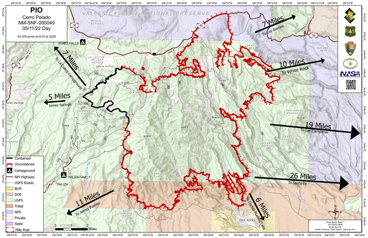
Cerro Pelado Fire Update for Wednesday May 11
Related Incident: Cerro Pelado
Publication Type: News
Cerro Pelado Fire Update, Wednesday, May 11, 2022
Info Office Hours: 8 am - 8 pm Phone: 505-312-4593 and 303-918-4004 Email: 2022.CerroPelado@firenet.gov
InciWeb: https://inciweb.nwcg.gov/incident/8075/
Twitter: https://twitter.com/SantafeNF
Facebook: https://www.facebook.com/2022.Cerropeladofire
Acreage: 43,376 acres
Containment: 11%
Personnel and Equipment: 1,017 total personnel; 47 engines, 11 Type 1 hand crews, 15 Type 2 hand crews, 6 Type 2 initial attack crews, 9 helicopters, 2 scooper planes, 10 dozers, 1 masticator, 2 ambulances, 1 rapid medical extraction unit and 17 water tenders. 2 Air National Guard helicopters are on standby.
Yesterday: A Red Flag Weather warning was in effect. Though the area experienced strong gusts and low relative humidity (RH), no drastic fire movement occurred. Wind conditions allowed air operations to continue throughout most of the day, with scooper planes and helicopters dropping water throughout the fire area. Crews concentrated northeastern fire operations around Forest Road (FR) 287, using this road as a primary containment line east of Alamo Canyon. Firefighters continued to establish and strengthen containment lines along the eastern perimeter of the fire, where the fire continued backing and flanking. Rocky terrain reduced the intensity of the southern portion of the fire and crews monitored as it slowly crept toward Highway 267. Firefighters strengthened containment lines along the fire’s western perimeter near Hondo Canyon. The northwestern corner of the fire remained contained. The use of heavy equipment like dozers and masticators reduced fuels and viability. The structure protection group continued operations throughout all areas. Fire operations coordinated with the Pueblo of Cochiti and their resources, continuing to assess and provide protection for structures in the Cochiti Lake area.
Today: A Red Flag Weather warning is still in effect due to sustained windy and dry conditions with low relative humidity (RH). These conditions are expected to contribute to fire growth potential. The strongest gusts will occur in the late afternoon and early evening hours before a dry cold front moves into the area. Air operations will begin as soon as conditions allow, before strong evening winds create unsafe flight conditions. The use of heavy equipment like dozers and masticators will resume to reduce fuels and fuel viability, especially along the southern and northern fire perimeters, which are more conducive to heavy equipment operations.
In the northeastern portion of the fire, fuel has become sparse as the fire moves northeast through the Las Conchas fire footprint. Crews will resume work on FR 280 to reinforce the containment line and will concentrate operations around FR 287. Firefighters will also continue to establish and strengthen containment lines along the eastern perimeter of the fire, especially along Dome Lookout Road, where the fire will continue backing and flanking eastward. Rocky terrain has reduced the fire intensity of the southern portion. Crews will resume monitoring as it slowly creeps toward Highway 267. Firefighters will strengthen containment lines along the fire’s western perimeter near Hondo Canyon. The northwestern portion of the fire remains contained and crews will resume evaluation. Crews will monitor spot fires throughout the fire area and will suppress them as they occur.
Weather conditions, difficult terrain, and environmental hazards will continue to challenge direct suppression efforts. Firefighters and line safety officers are using lookouts, communications, escape routes and safety zones (LCES) to protect line personnel. Firefighters are rotating out of extreme smoke conditions to help relieve fatigue. Wind events continue to create hazards from falling trees, so active mitigation measures are necessary across the incident to protect human life.
Operation crews continue to communicate with tribal representatives, community leaders, private cooperators, and Los Alamos National Laboratory staff to coordinate firefighting resources, protect structures, and keep community members safe. The National Park Service will continue structure protection in Bandelier National Monument and Valles Caldera National Preserve. The structure protection group will continue operations throughout all areas.
Weather and Fire Behavior: A Red Flag Warning is in effect as gusty south winds and low RH create critical fire weather conditions. Winds are expected to increase Wednesday with south/southwest winds of 30-35 mph. Gusts up to 45 mph will occur across the fire and will be strongest across the eastern half. RH will remain around 10 percent with temperatures in the 70s to lower 80s. There will be some afternoon clouds.
Conditions will contribute to fire growth potential, especially on the east side of the fire. Strong west winds may push the fire north and east, with low-intensity fire activity occurring in the Los Conchas Fire footprint. Low fuels in this area will impede the fire’s ability to build a large fire front. The north portion of the fire will continue to back slowly towards containment lines along Highway 4.
Evacuations, Shelter Areas: Los Alamos County remains in “Set” evacuation level. The communities of Cochiti Mesa and the Peralta Canyon area, including Cox Ranch, remain under “Go” evacuation status. Four additional residences are evacuated in the Cox Ranch area between mile marker 36 and 40 along Highway 4. Los Alamos residents that have special needs or are access-challenged will continue evacuation. Los Alamos High School is closed until further notice. Evacuations for Sierra de Los Pinos and Valles Caldera National Preserve remain in “Set” mode, meaning residents should be ready to leave at a moment’s notice. Jemez Springs, La Cueva and Cochiti Lake area remain in “Ready” status. Counties will provide updated information on evacuations as needed.
Air quality: Winds will blow smoke and dust into communities north and northeast of the fires, including the communities of Los Alamos, White Rock, and Santa Clara. Overall conditions are expected to remain GOOD to MODERATE. Santa Fe and Cochiti Pueblo could see brief periods of light smoke and haze. Information on air quality is at New Mexico Department of Health Environmental Public Health Tracking, https://nmtracking.org/fire. An interactive smoke map at https://fire.airnow.gov/ allows you to zoom into your area to see the latest smoke conditions.
Closures: Highway 4 remains closed to all traffic from mile marker 34 to mile marker 50 (at the junction of Highway 4 and 501) due to fire activity. Fire equipment and firefighters will be working along Highway 4 and accessing the fire, especially at intersections with FR 10 and FR 280. Heavy traffic impedes firefighting efforts and endangers firefighter safety. The most updated road closure information can be found here: https://www.nmroads.com/mapIndex.html
The Santa Fe National Forest has issued a closure order for the Cerro Pelado fire area and a second closure order for the Cerro Pelado Firefighter Camp along FR 376. The purpose of both orders is to protect public health and safety due to extreme fire danger in the Restricted Area. Bandelier National Monument and Valles Caldera National Preserve remain closed until further notice.
Fire Restrictions: Stage II Fire Restrictions are in effect for the Santa Fe National Forest, which prohibits all campfires and other hazardous activities. Due to ongoing fire threats, Sandoval County will not issue burn permits. Stage III Fire Restrictions are in effect for Cochiti Pueblo.
Temporary Flight Restriction: There is a flight restriction on the area over the fire (10 nautical miles southwest of Los Alamos, NOTAM 2/2366) to provide a safe environment for firefighting operations. Drones over the fire are also prohibited because their presence can disrupt air resources and pose additional fire hazard. More information: https://tfr.faa.gov/save_pages/detail_2_6919.html.
Smoke Report for Cerro Pelado Fire Wednesday May 11
Related Incident: Cerro Pelado
Publication Type: News
There is an air quality alert through 1pm Thursday. Very dry and windy conditions persist. Fire growth and increase smoke production is possible. South-Southwest winds will blow smoke and dust into communities northeast of the fires. More information regarding this alert can be found: Current Smoke Outlook for Northern New Mexico (airfire.org)
Cerro Pelado Fire Update for Tuesday May 10
Related Incident: Cerro Pelado
Publication Type: News
Cerro Pelado Fire Update
Tuesday, May 10, 2022
Info Office Hours: 8 am - 8 pm Phone: 505-312-4593 and 303-918-4004
Email: 2022.CerroPelado@firenet.gov
InciWeb: https://inciweb.nwcg.gov/incident/8075/
Twitter: https://twitter.com/SantafeNF
Facebook: https://www.facebook.com/2022.Cerropeladofire
Containment: 11%
Yesterday: Due to the Red Flag Warning, which brought west/southwest winds of over 40 mph, the east side of the fire was the major focus of operations. Firefighters continued to use hose lay and handlines on the northeast and eastern perimeters. Air resources operated until they were grounded due to unsafe wind conditions. Operations focused on suppressing the spot fires east of Forest Road (FR) 289 to connect and flank the fire. Work continued along the fire perimeter at Highway 4 on the north, FR 266 on the west, and FR 270 on the south. The fire slowly progressed southward, toward containment lines, through sparse fuels. Masticators continued to grind vegetation along Highway 4. The north side of the fire continued backing slowly toward Highway 4. Structure protection resumed in Cochiti Lake, Bandelier National Monument, and Valles Caldera National Preserve.
Fire Restrictions: Stage II Fire Restrictions are in effect for the Santa Fe National Forest, which prohibits all campfires and other hazardous activities. Due to ongoing fire threats, Sandoval County will not issue burn permits.
Smoke Report for Cerro Pelado Fire Tuesday May 10
Related Incident: Cerro Pelado
Publication Type: News
There is an air quality alert through noon Tuesday, May 10. Strong south and southwest winds will blow smoke and dust into communities north and northeast of the fire. See the attached document below for more information.
Cerro Pelado Fire Update for Monday May 9
Related Incident: Cerro Pelado
Publication Type: News
Fire Information Office Hours: 8 a.m. - 8 p.m. Phone: 505-312-4593 and 303-918-4004 Email: 2022.CerroPelado@firenet.gov InciWeb: https://inciweb.nwcg.gov/incident/8075/ Twitter: https://twitter.com/SantafeNF
Facebook: https://www.facebook.com/2022.Cerropeladofire
Acreage: 40,958 acres Containment: 11%
Personnel and Equipment: 869 total personnel; 40 engines, 9 Type 1 hand crews, 10 Type 2 hand crews, 5 Type 2 initial attack crews, 9 helicopters, 2 scooper planes, 10 dozers, 1 masticator, 2 ambulances, 1 rapid medical extraction unit and 15 water tenders. 2 Air National Guard helicopters are on standby.
Yesterday: Firefighters were patrolling and monitoring the northwest perimeter of the fire. U.S. Department of Energy masticators continued to grind up burnable vegetation along Highway 4. Highway 4 remained closed from mile marker 34 to mile marker 50 (junction of Hwy 4 and 501). The west side of the fire continued to slowly back towards the constructed firelines along Forest Road (FR) 266. Hand crews used check lines to slow fire growth and keep fire intensities low. There was minimal movement on the south side of the fire due to sparse fuels. The southwest corner of the fire had little movement, advancing only when drainages with timber had fuel to consume. On the eastern side of the fire, the southern portion of FR 289 is still considered a primary line as the fire continues to advance east with 30 mph winds. The spot fire that crossed FR 289 advanced onto the east mesa and slowed due to green grass fuels. Most eastward movement occurred in steep canyons. FR 289 has been prepped and plumbed. Fire operations continued to prep firelines on roads east of FR 289. Super scooper planes and heavy helicopters continued to drop water on the eastern perimeter until high winds prevented further flights around 3:00pm. AM Radio 1610 continued to operate as a public service to give news of firefighting efforts on Saturday. No new structural losses were reported.
Today: Firefighters will continue to work along the perimeter of the fire along Highway 4 on the north, FR 266 on the west, FR 270 on the south. The fire is expected to slowly progress southward, toward containment lines, due to sparse fuels. Masticators will continue to grind vegetation along Highway 4. The north side of the fire is expected to continue backing slowly towards Highway 4.
The east side of the fire will be the major focus of fire operations today due to Red Flag wind conditions and expected west to southwest 35+ mph winds. Firefighters will use hose lines and handlines on the northeast and eastern perimeters. Operations will focus on suppressing the spot fires east of FR 289, connecting and flanking the fire. Fire operations noted the fire has slowed significantly due to green grass on the mesas. Crews and aerial observers will verify and suppress all spots as they are discovered. Air operations will continue to start one hour earlier before winds become too strong to fly. Firefighters will coordinate with the National Park Service for structure protection in Bandelier National Monument and Valles Caldera National Preserve. Structure protection group has continued operations throughout all areas with homes and structures. Fire Operations will coordinate with the Pueblo of Cochiti and their resources, continuing to assess and provide protection for structures in the Cochiti Lake area. Due to extreme conditions, firefighters and line safety officers are using lookouts, communications, escape routes and safety zones (LCES) to protect line personnel. Line safety has been making sure firefighters are rotating out of extreme smoke conditions to help relieve fatigue.
Weather and Fire Behavior: Today’s weather calls for a Red Flag Warning due to gusty winds 30+ mph, low relative humidity in the single digits and high temperatures. Weather predictions expect near historic wind levels over the next two days. Expect creeping and smoldering fire on the north, with active fire near Kitty Lake Dip. On the west side, and that portion of the fire on Pueblo of Jemez, today’s wind may push the fire towards Hondo Canyon. Expect backing and flanking fire activity on the south side of the fire with no significant growth. There is potential for rapid fire spread as the fire moves east and southeast, especially if winds align with drainages. Fire potential is still a threat in the east side, with fire potentially moving towards West Mesa. The east side of the fire has the greatest potential for fire growth. The north portion of the fire will continue to back slowly towards containment lines along Highway 4.
Evacuations, Shelter Areas: The communities of Cochiti Mesa and the Peralta Canyon area, including Cox Ranch, remain under a “Go” evacuation status. The Sandoval County Fire Department and Emergency Management will provide updated information on evacuations as needed. Evacuations for Sierra de Los Pinos and Valles Caldera National Preserve remain in “Set” mode, meaning residents should be ready to leave at a moment’s notice. These areas could return to “Go” if conditions change and the fire threatens the community again. Jemez Springs, La Cueva and Cochiti Lake area remain in “Ready” status. Los Alamos County has moved into the “Set” evacuation levels as of 8:00 am today.
Air quality: Information on air quality is at New Mexico Department of Health Environmental Public Health Tracking, https://nmtracking.org./fire. An interactive smoke map at https://fire.airnow.gov/ allows you to zoom into your area to see the latest smoke conditions.
Closures: Highway 4 remains closed to all traffic from mile marker 34 to mile marker 50 (at the junction of Hwy 4 and 501) due to fire activity. Fire equipment and firefighters will be working along Highway 4 and accessing the fire, especially at intersections with FR 10 and FR 280. Heavy traffic impedes firefighting efforts and endangers firefighter safety. The most updated road closure information can be found here: https://www.nmroads.com/mapIndex.html
The Santa Fe National Forest has issued a closure order for the Cerro Pelado fire area and a second closure order for the Cerro Pelado Firefighter Camp along FR 376. The purpose of both orders is to protect public health and safety due to extreme fire danger in the Restricted Area. Bandelier National Monument and Valles Caldera National Preserve remain closed due to fire activity until further notice.
Fire Restrictions: Stage II Fire Restrictions are in effect for the Santa Fe National Forest, which prohibits all campfires and other hazardous activities. Due to ongoing fire threats, Sandoval County will not issue burn permits.
Temporary Flight Restriction (TFR): There is a flight restriction on the area over the fire (10 nautical miles southwest of Los Alamos, NOTAM 2/2366). https://tfr.faa.gov/save_pages/detail_2_6919.html. Drones over the fire are also prohibited.
Evacuation Level Change for Los Alamos County Los Alamos National Lab
Related Incident: Cerro Pelado
Publication Type: Announcement
Los Alamos County Emergency Management announced that Los Alamos County and Los Alamos National Lab will move from the READY status to SET status at 8 am on Monday, May 9, 2022.
SET means to prepare yourself and your home for the possibility of evacuation before wildfire arrives. Some actions include:
- creating a Wildfire Action Plan that includes evacuation planning for your home, family, and pets
- Assemble an Emergency Supply Kit for each person in your household
- Fill out a Family Communication Plan that includes important evacuation and contact information
- Stay informed by following local media, local fire alerts, and county emergency notifications.
Cerro Pelado Fire Update for Sunday May 8
Related Incident: Cerro Pelado
Publication Type: News
Cerro Pelado Fire Update Sunday, May 8, 2022
Hours: 8 a.m. - 8 p.m.
Phone: 505-312-4593 and 303-918-4004
Email: 2022.CerroPelado@firenet.gov
InciWeb: https://inciweb.nwcg.gov/incident/8075/
Twitter: https://twitter.com/SantafeNF
Facebook: https://www.facebook.com/2022.Cerropeladofire
Personnel and Equipment: 872 total personnel; 42 engines, 8 Type 1 hand crews, 11 Type 2 hand crews, 6 Type 2 initial
Yesterday: Firefighters are patrolling the northwest perimeter of the fire. U.S. Department of Energy masticators continued to grind up burnable vegetation along Highway 4 west of the tactical burns from two days ago. Highway 4 remains closed from mile marker 34 to mile marker 50 (junction of Hwy 4 and 501). Hand crews secured the spot fire from Thursday on the west side of the fire (north of Meadow helicopter dip site). The fire continued to slowly back towards the constructed west firelines along Forest Road (FR) 266. On the south side of the fire, there was minimal movement, and fuels on the south side of the fire are sparse. The southwest corner of the fire had little movement, advancing only when drainages with timber had some fuel to consume. On the eastern side of the fire FR 289 is considered a primary line as the fire continued to advance towards FR 289 with 35 mph winds. A spot fire crossed FR 289 late in the afternoon. Night operations called conditions on the line “unbearable” due to wind, dust, smoke and heat.
Weather and Fire Behavior: Today’s weather calls for a Red Flag Warning due to gusty winds 50+ mph, low relative humidity in the single digits and high temperatures. Weather predictions are expecting near historic levels of wind over the next three days. Expect flanking fire on the north, with active fire near Kitty Lake. The fire is expected to continue backing on the west side of the fire towards containment lines on FR 266. As the fire moves southeast and east, there is potential for rapid fire spread, especially if winds align with drainages. In the northeast, winds may align with canyons and there is potential for high spread rates. The east side of the fire has the greatest potential for fire growth up to 5 miles if it exceeds suppression action. Fire spread potential for the south side is expected to slow with backing fire, and is moving to containment lines.
Evacuations, Shelter Areas: The communities of Cochiti Mesa and the Peralta Canyon area, including Cox Ranch, remain under a “Go” evacuation status. The Sandoval County Fire Department and Emergency Management will provide updated information on evacuations, as needed. Evacuations for Sierra de Los Pinos and Valles Caldera National Preserve remain in “Set” mode, meaning being ready to leave at a moment’s notice. If conditions change and the fire threatens the community again, these areas could return to “Go.” Los Alamos County, Jemez Springs, La Cueva and Cochiti Lake area remain in “Ready” status. No evacuation levels have changed at the time of this update.
Fire Restrictions: Stage II Fire Restrictions are in effect for the Santa Fe National Forest, which prohibits all campfires and other hazardous activities. Due to ongoing fire threats, Sandoval County will not issue burn permits.
Smoke Report for Cerro Pelado Fire Sunday May 8
Related Incident: Cerro Pelado
Publication Type: News
Cerro Peldao Fire May 8, 2022 Smoke ReportLink to the forecast https://outlooks.airfire.org/outlook/736b0fb8 AIR QUALITY ALERT Through noon Sunday. Blowing smoke and dust are expected to be transported towards the northeast from active fires throughout this period.https://forecast.weather.gov/product.php?site=NWS...High winds are helping to transport smoke out of most of the forecast area today and tomorrow. Expect mostly GOOD air quality with haze across the forecast area with the exception of Los Alamos, White Rock and Santa Clara areas which will likely see MODERATE air quality today and tomorrow with potential periods of Unhealthy for Sensitive Groups.