
Updated Fire Closure Information
Related Incident: Cerro Pelado Post-Fire BAER
Publication Type: Closures
For the most up to date fire closure information, please visit https://inciweb.nwcg.gov/incident/closures/8069/.
Hermits PeakCalf Canyon PostFire BAER Phase 3 Assessment Summary Released
Related Incident: Hermits Peak and Calf Canyon BAER
Publication Type: News
HERMITS PEAK-CALF CANYON POST-FIRE BAER PHASE 3 ASSESSMENT SUMMARY RELEASED
The Forest Service Santa Fe National Forest (USFS) completed its BAER post-fire Phase 3 assessment of the Hermits Peak-Calf Canyon burned areas and affected watersheds to determine their response, soil conditions, potential threats, and recommended BAER emergency stabilization measures and actions on National Forest System (NFS) lands. BAER emergency treatments and activities are designed to decreased possible impacts to critical values from the burned areas during rainstorm events such as: life and safety, property, critical natural resources, and cultural resources.
NOTE: Attached below as “Related Information” is a PDF document called “HPCC Phase 3 Post-Fire BAER Assessment Summary”.
BAER AERIAL SEEDING MULCHING TREATMENTS SET TO BEGIN
Related Incident: Hermits Peak and Calf Canyon BAER
Publication Type: News
August 12, 2022- The Santa Fe National Forest (SFNF) Burned Area Emergency Response (BAER) team will begin aerial seeding and mulching treatments on National Forest System (NFS) lands in the south-central portion of the Hermits Peak-Calf Canyon Fire on August 14, 2022. Rampart Helicopter Services was awarded the contract and will be working closely with the BAER team to implement the planned seeding and mulching treatments.
BAER SAFETY MESSAGE: Everyone near and downstream from the burned areas should remain alert and stay updated on weather conditions that may result in heavy rains and increased water runoff. Flash flooding may occur quickly during heavy rain events – be prepared to act. Current weather and emergency notifications can be found at the National Weather Service website: www.weather.gov/abq/.
EXPECT TO SEE HELICOPTERS FLYING OVER THE BURNED AREA IN THE UPCOMING DAYS
Related Incident: Hermits Peak and Calf Canyon BAER
Publication Type: Announcement
EXPECT TO SEE HELICOPTERS FLYING OVER THE BURNED AREA IN THE UPCOMING DAYS.
On Friday, August 12, helicopters will begin flying over the south-central Hermits Peak-Calf Canyon Fire, around Gallinas Canyon. Their mission is to complete reconnaissance flights in preparation for the upcoming aerial seeding and mulching project for erosion mitigation.
Please do not be alarmed if you see helicopters flying towards the burned area. Do not call 911.
Please see the attached map for seeding area information. More information will be available about the aerial seeding project in the upcoming days.
Updated Fire Closure Information
Related Incident: Hermits Peak and Calf Canyon BAER
Publication Type: Closures
For the most up to date fire closure information, please visit https://inciweb.nwcg.gov/incident/closures/8069/.
Reduced Closure Area for Post Wildfire Suppression Repair
Related Incident: Bear Trap Fire
Publication Type: News
Reduced Closure Area for Post Wildfire Suppression Repair
Bear Trap Fire - Magdalena Ranger District - San Mateo Mountains
Order Number 03-03-03-22-01
For more information on this order contact:
Magdalena Ranger District Office: 575-854-2281
The official order 03-03-03-22-01 posted on the Cibola NF & NGs website under Alerts & Notices.
# # #
USDA is an equal opportunity provider, employer, and lender.
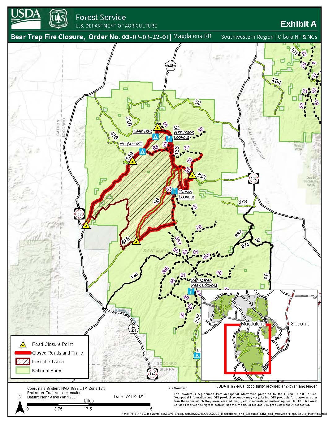
Bear Trap Fire Area Road and Trail Closure Order 0303032 reduced area
Related Incident: Bear Trap Fire
Publication Type: News
Order Number: # 03-03-03-22-01U.S. Department of Agriculture, U.S. Forest Service Cibola National Forest
Magdalena Ranger DistrictBear Trap Fire Area/Road/Trail Closure - Reduced Area of Closure
See Map attached.
PROHIBITIONSPursuant to 16 U.S.C. § 551 and 36 C.F.R. § 261.50(a) and (b), the following are prohibited on the National Forest System (NFS) lands, roads, and trails in the Magdalena Ranger District, Cibola National Forest and Grasslands, described below and shown on the attached map, incorporated into this Order as Exhibit A (the “Described Area/Roads/Trails”):1. Going into or being upon the Described Area. 36 C.F.R. § 261.53(e).2. Being on the Roads. 36 C.F.R. § 261.53(e).3. Being on the Trails. 36 C.F.R. § 261.55(a).
EXEMPTIONSPursuant to 36 C.F.R. § 261.50(e), the following persons are exempt from this Order:1. Persons with Forest Service Permit No. FS-7700-48 (Permit for Use of Roads, Trails, or Areas Restricted by Regulation or Order), specifically exempting them from this Order or a written determination by a Forest Service authorized officer that a permit is not required under 36 C.F.R. § 251.50(e)(1) or (2).2. Any Federal, State, or Local Officer, or member of an organized rescue or firefighting resource in the performance of official duty.3. Landowners crossing National Forest System lands to access their private property.
DESCRIBED AREA/ROADS/TRAILSThe Described Area consists of all National Forest System (NFS) lands within the following description. The northwestern boundary will consist of NFS Road (FR) 549 starting at the southwest end of FR 549 to include all of FR 549 to the point it intersects with FR 138. The southwestern boundary will start at the intersection of FR 549 and FR 73 heading northwest along FR 73 until intersection of FR 73 and FR 72. Then following FR 72 south to FR 94 and continuing until reaching FR 478. The southern boundary will start at the junction of FR 94 and FR 478 to include all of FR 478 to the east of the intersection ending at NFS Trail 43. The eastern boundary will start at the junction of FR 478 and NFS Trail 43 continuing north along NFS Trail 43 to Grassy Lookout. Then following NFS Trail 63 northeast to the junction of FR 330. The northeastern boundary will start at the intersection of FR 330 and NFS Trail 63 continuing northwest along NFS Trail 92 continuing through the intersection of FR 138, until FR 138 intersects with FR 549.All NFS Roads and Trails identified above that comprise the Described Area boundary are closed, as are all NFS Roads and Trails within the Described Area boundary also to include NFS Trail 36.PURPOSE
The purpose of this Order is to protect public health and safety from post wildfire hazards and provide for firefighter and contractor safety during post wildfire suppression repair.
IMPLEMENTATION1. This Order shall be in effect from July 25, 2022, at 8:00 a.m., through August 31, 2022, at 11:59 p.m., unless rescinded.2. A map identifying the Described Area/Roads/Trails is attached and made part of this Order as Exhibit A. For a digital version of this Order and Exhibit A, go to https://www.fs.usda.gov/alerts/cibola/alerts-notices3. Unless otherwise expressly defined in this Order, the terms used in this Order are defined by the regulations of the Secretary of Agriculture, 36 C.F.R. Chapter II, Parts 200-299. If there are terms in this Order that are not expressly defined in the Order or 36 C.F.R. Chapter II, Parts 200-299, their meaning shall be determined by their plain language definitions.4. A violation of the above prohibitions is punishable as a Class B misdemeanor by a fine of not more than $5,000 for individuals and $10,000 for organizations, or by imprisonment for not more than six months, or both. 16 U.S.C. § 551; 18 U.S.C. §§ 3559, 3571, and 3581.5. Contact the Magdalena Ranger District in Magdalena, NM, (575) 854-2281, and the Cibola National Forest Supervisor’s Office in Albuquerque, NM, (505) 346-3900, for more information about this Order.6.This Order supersedes any previous Orders prohibiting the same or similar acts in/on the same Described Area/Roads/Trails.Signed and issued on July 28, 2022._______________________Forest SupervisorCibola National Forest and Grasslands
SFNF Updates Closure Order for Cerro Pelado Fire Area
Related Incident: Cerro Pelado
Publication Type: Closures
Jemez Falls, the 70-foot waterfall on the East Fork of the Jemez River, will remain closed along with Trail 137 from the East Fork Trailhead to Jemez Falls and on to Battleship Rock. In addition, the following developed recreation sites will remain closed due to the risk of flash flooding:
and the Jemez Ranger District Office. For additional information, please contact the Jemez Ranger District at 575-829-3535. All current closure orders are posted on the Alerts and Notices page of the website.
# # #
USDA is an equal opportunity provider, employer and lender.
Video Calf Canyon Operations Update for August 15 2022
Related Incident: Calf Canyon
Publication Type: News
Calf Canyon Fire Update August 15 2022
Related Incident: Calf Canyon
Publication Type: News
Break in Monsoon Over the Weekend
Acres: 341,73
Containment: 98%
Total personnel: 488
Start Date: Hermits Peak: April 6, 2022; Calf Canyon: April 19, 2022
Cause: Hermits Peak: Spot fires from prescribed burn; Calf Canyon: Holdover fire from prescribed pile burn
Location: 12 miles NW of Las Vegas, NM
Fuels: Heavy mixed conifer, ponderosa pine, brush, and grass
Operations: Over the weekend drier weather over the fire area allowed for safe access for firefighters and heavy equipment to reengage and continue suppression assessments and repairs. Incident personnel continued to support work on removing debris, mud and rocks off roads damaged by flooding. Fire officials would like to remind residents and visitors to slow down while driving on roads in and around the fire area and to obey all traffic warnings.
Closures and Restrictions: The Santa Fe National Forest has reduced the fire closure area opening additional access to the Pecos Wilderness. To view the new closure order and map visit Santa Fe - Alerts & Notices (usda.gov). Monsoon weather and completion of suppression repair activities play a part in the decision to lift closure orders and the safety of the public, firefighter, and incident support personnel is always our first priority.
Weather: High pressure will weaken and allow more favorable monsoonal flow of moisture into the region. Expect scattered showers and thunderstorms on Tuesday, with a significant increase in storms possible Thursday and Friday. Daily showers and storms will increase the risk for flash flooding with the greatest risk from Tuesday afternoon through at least Thursday. The greatest risk will be from Tuesday afternoon through at least Thursday. Afternoon temperatures will be cooling with increased relative humidity.
Fire Flooding and Recovery Resources: 2022 Wildland Fires Resources Hotline | After Wildfire New Mexico Guide | Hermits Peak and Calf Canyon Fires Burned Area Emergency Response
For questions or concerns related to flooding, please call the New Mexico State Emergency Operations Center at 1-800-432-2080. For federal disaster with fire or flood damage to your primary residence, please call the FEMA Helpline at 1-800-621-3362.
Private Land Suppression Repair Survey (English and Spanish). Call 720-417-8048 for assistance in English, or 505-398-3889 for assistance in Spanish.
Fire Information: Office Hours: 8:00 AM – 8:00 PM | Phone: 505-356-2636 | Email: 2022.hermitspeak@firenet.gov
Online Fire Information Resources: Inciweb | Santa Fe National Forest Facebook | nmfireinfo.com |Santa Fe National Forest Twitter | YouTube | Santa Fe National Forest| Carson National Forest