
Flood Watch in Effect for Hermits PeakCalf Canyon Burn Scar
Related Incident: Hermits Peak and Calf Canyon BAER
Publication Type: Announcement
Flood Watch in Effect for Hermits Peak-Calf Canyon Burn Scar
The National Weather Service has issued a Flood Watch for Friday September 9th in effect from noon MDT through the evening. Effected areas include East Slopes and Southern Sangre de Cristo Mountains, including area burned by the Hermits Peak-Calf Canyon Fire. Locally heavy rainfall will be possible Friday through Tuesday with a risk of flash flooding each day.
BAER Safety Message: Everyone near and downstream from the burned areas should remain alert and stay updated on weather conditions that may result in heavy rains and increased water runoff. Flash flooding may occur quickly during heavy rain events. Be prepared to act. Current weather and emergency notification can be found at the National Weather Service website www.weather.gov/abq.
Aerial Seeding and Mulching Operations Completed
Related Incident: Hermits Peak and Calf Canyon BAER
Publication Type: News
Aerial seeding and mulching completed on Hermits Peak-Calf Canyon Fire
On September 5th, contractors completed the critical work of applying grass seed and mulch across approximately 9,400 acres of the Hermits Peak-Calf Canyon Fire that resulted in moderate to high soil burn severity. Both wood mulch and certified weed free straw mulch were aerially applied to areas in the Gallinas Creek and Tecolote Creek watersheds. The work was completed ahead of schedule. In many areas, the grass seed is already germinating. This will provide a jump start to vegetation recovery and help to stabilize soils in the coming months.
All post-fire response activities are designed to decrease potential impacts to critical resources, but they do not eliminate the threats posed by post-fire flowing and debris flows. Everyone near and downstream from burned areas should remain alert and stay updated on weather conditions that may result in rain and increased water runoff.
BAER SAFETY MESSAGE: Everyone near and downstream from the burned areas should remain alert and stay updated on weather conditions that may result in rain and increased water runoff. Flash flooding may occur quickly during rain events. Be prepared to act. Current weather and emergency notifications can be found at the National Weather Service website: www.weather.gov/abq/.
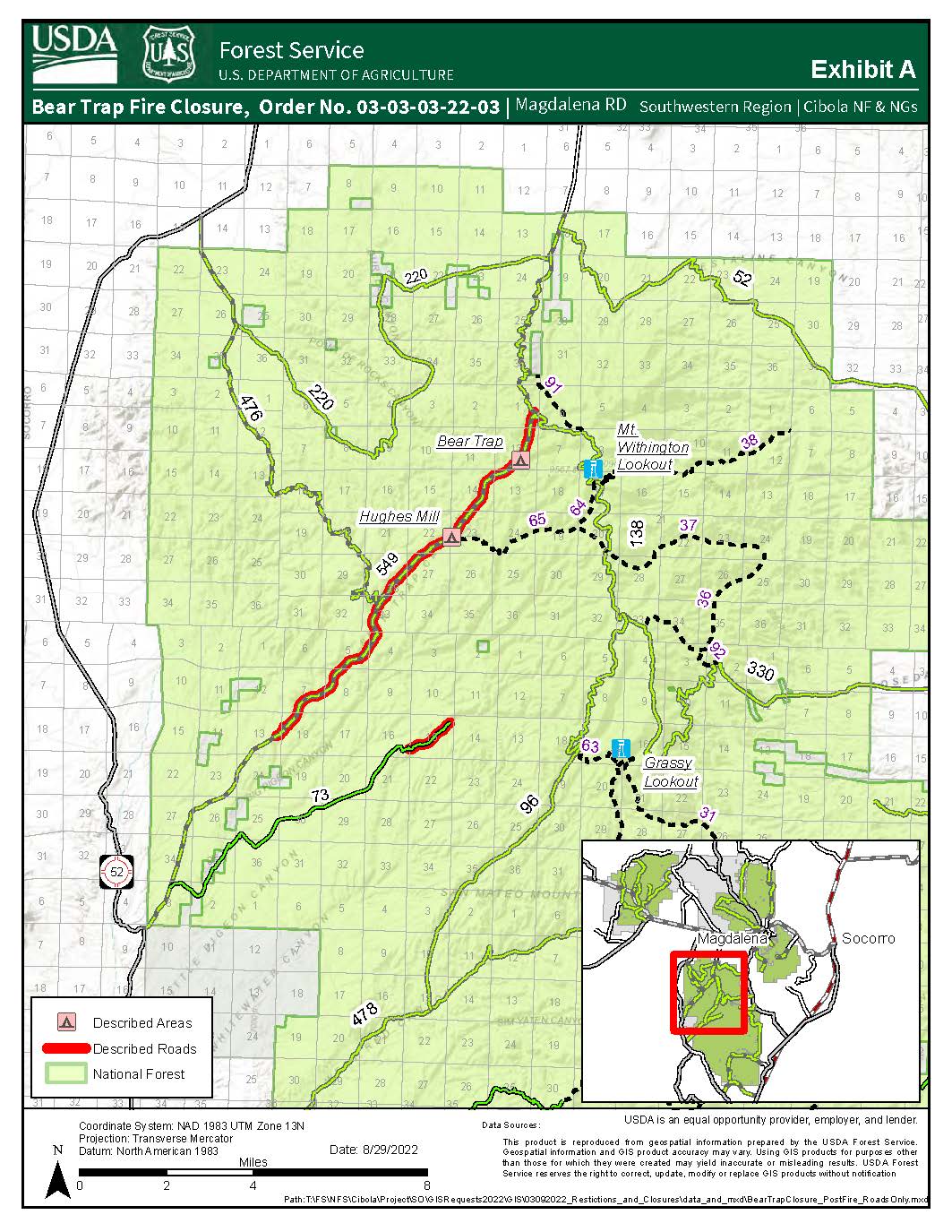
Bear Trap Fire Area and Road Closure order 0303032203
Related Incident: Bear Trap Fire
Publication Type: News
Bear Trap Fire
Area and Road Closures
Magdalena Ranger District - San Mateo Mountains
Order Number 03-03-03-22-03
The following developed recreation sites are closed to entry: Bear Trap and Hughes Mill Campgrounds.
Pursuant to 36 C.F.R. § 261.50(e), the following persons are exempt from this Order:
BAER work includes aerial seeding operations on Lincoln National Forest
Related Incident: McBride Post-Fire BAER
Publication Type: News
RUIDOSO, NM, Aug. 29, 2022 – The Burned Area Emergency Response (BAER) team has conducted field assessments and identified priority treatment locations within the McBride fire area where moderate to high soil burn severity occurred. The treatment will involve aerial seeding, by helicopter, of 335 acres. This treatment will help stabilize the hillsides impacted by the fire to reduce post-fire runoff and erosion in the Devils Canyon, Middle Rio Ruidoso and Upper Rio Ruidoso Creek/River watersheds on National Forest System lands.
Up to 50 pounds of seed mix per acre will be strategically cast along the hillsides by helicopter. The seed mix includes barley (Hordeum vulgare), western wheatgrass (Pascopyrum smithii), and sideoats grama (Bouteloua curtipendul). The aerial seeding is scheduled to take place on September 1 and 2.
PLEASE USE EXTREME CAUTION on FS Road 120: As a safety measure, fire prevention patrol units will be stationed along sections of FS Road 120 to ensure that traffic moves steadily and safely through the corridor during helicopter operations.
BAER teams focus on emergency actions necessary to protect human life and safety, property, and natural and cultural resources, including affected watersheds. BAER assessments identify unacceptable risks on federal lands from post-fire threats and help land managers prepare burned areas for potential threats from rainstorms.
BAER Safety Message: Everyone near and downstream from the burned areas should remain alert and stay updated on weather conditions that may result in heavy rains and increased water runoff. Flash flooding may occur quickly during heavy rain events – be prepared to act. Current weather and emergency notifications can be found at the National Weather Service website: www.weather.gov/abq.
Cerro Pelado Burned Area Closure Lifted
Related Incident: Cerro Pelado
Publication Type: News
The East Fork Trail will remain open, but if you plan to hike in that area, please be aware that crews will be spraying the herbicide Rodeo®, a formulation of glyphosate registered by the Environmental Protection Agency for use in riparian and aquatic habitats. Accompanied by Forest Service staff, crews will use backpack sprayers to apply the herbicide directly onto oxeye daisy plants.
# # #
USDA is an equal opportunity provider, employer and lender.
Calf Canyon Hermits Peak Update September 14
Related Incident: Calf Canyon
Publication Type: News
TAOS, NM – Sept. 14, 2022 – The Type 2 Southwest Area Incident Management Team 5 will transfer management of the Calf Canyon-Hermits Peak Fire to a Type 3 Incident Management Team on Sunday, Sept. 18, at 6:00 p.m. Downsizing from a Type 2 organization to a Type 3 is a result of the work accomplished by several incident management teams over the course of this incident.
This will be the final update unless something significant occurs on this incident.
IMPORTANT REMINDER: There is an Open House for residents impacted by the Calf Canyon-Hermits Peak Fire tomorrow, Sept. 15, at the Abe Montoya Recreation Center (1751 N. Grand Ave., Las Vegas, NM) from 5:00 p.m. to 7:00 p.m. Representatives from various local, state, and federal agencies will be available to provide information about available assistance. There will not be a public meeting associated with the open house.
Operations: Although the burn area received rain this past week, crews continued to make excellent progress with fire suppression repair operations on private lands, dozer lines, roads, and culverts. Crews completed the timber salvage removal and are now repairing dozer lines and rehabilitating roads impacted by those operations.
Private landowners can continue to submit requests for fire suppression repair work by calling 720-417-8048.
Closures and Restrictions: Additional areas of the Camino Real Ranger District on the Carson National Forest are scheduled to reopen on Sept. 14. Current closure and restriction information is available on the Santa Fe - Alerts & Notices page (https://www.fs.usda.gov/alerts/santafe/alerts-notices) and Carson National Forest - Alerts & Notices page (https://www.fs.usda.gov/alerts/carson/alerts-notices). Both forests continue assessing conditions looking for opportunities to reduce the closure areas as soon as possible while keeping public and firefighter safety as the highest priority. As hunting season begins, details and maps for newly reopened areas will continue to be updated on the Santa Fe and Carson Forest Alerts & Notices webpages and social media.
Weather: The area will begin experiencing a warming and drying trend this week through the weekend, with temperatures in the 70s and 80s.
Fire Flooding and Recovery Resources: 2022 Wildland Fires Resources Hotline: https://www.nmdhsem.org/2022- wildfires/ | After Wildfire New Mexico Guide: https://www.afterwildfirenm.org/ | Hermits Peak and Calf Canyon Fires Burned Area Emergency Response: https://inciweb.nwcg.gov/incident/8104/
For questions or concerns related to flooding, please call the New Mexico State Emergency Operations Center at 1-800- 432-2080. For federal disaster with fire or flood damage to your primary residence, please call the FEMA Helpline at 1- 800-621-3362.
Fire Information: Office Hours: 8:00 AM – 7:00 PM | Phone: 505-356-2636| Email: 2022.hermitspeak@firenet.gov
Online Fire Information Resources: inciweb.nwcg.gov/incident/8069/ | https://www.facebook.com/santafeNF/| nmfireinfo.com |Santa Fe National Forest Twitter (https://t.co/JiGpZ1sovK) | tinyurl.com/HermitsYouTube | Santa Fe National Forest (https://www.fs.usda.gov/main/santafe/home) | Carson National Forest (https://www.fs.usda.gov/carson)
Open HouseCalf CanyonHermits Peak Coordinated Recovery Response Sept 15
Related Incident: Calf Canyon
Publication Type: News
Calf Canyon-Hermits Peak Fire
Coordinated Recovery Response Open House
TAOS, NM – SEPT. 12, 2022 – Multiple agencies are coming together in Las Vegas, NM, on Thursday, Sept. 15, 2022, for an open house to provide a one-stop coordinated event for recovery response and resources. The open house will provide members of the public who have been impacted by the Calf Canyon-Hermits Peak Fire an opportunity to meet one-on-one with representatives from local, state, and federal partner agencies to find out about available assistance. There will not be a public meeting associated with the open house.
Date: Thursday, Sept. 15, 2022
Time: 5:00 p.m. – 7:00 p.m.
Location: Abe Montoya Recreation Center, 1751 N. Grand Ave., Las Vegas, NM
REMINDER for landowners whose property received damage due to fire suppression operations: The online Private Land Suppression Repair Survey will be discontinued after Monday, Sept. 12. However, the Private Land Suppression Repair phone line (720-417-8048) will remain open for new and existing suppression repair requests.
For questions contact the public information line at 505-356-2636 between 8:00 a.m. – 8:00 p.m.
# # #
Sept 15 Coordinated Recovery Response Open House
Related Incident: Calf Canyon
Publication Type: Announcement

Open House
Coordinated Recovery Response
Calf Canyon & Hermits Peak Fires
THURSDAY
SEPTEMBER 15, 2022
5-7PM
ABE MONTOYA RECREATION CENTER
1751 N. GRAND AVE.
LAS VEGAS, NM 87701
Local, State and Federal Partners will be available at information booths to answer questions and provide assistance to community members.
You may arrive at any time during the event.
For more information about this open house, call (505) 356-2636 between 8AM-8PM.
Calf Canyon Hermits Peak Update September 7
Related Incident: Calf Canyon
Publication Type: News
Highlights: The Southwest Incident Management Team 5 returned to take command of the Calf Canyon incident on Monday, September 5. Team 5 is glad to be back and serving the local communities once again. Private landowners whose property received damage due to fire suppression operations will have until September 12 to utilize the online Private Land Suppression Repair Survey. Just the online option will be discontinued. The Private Land Suppression Repair phone line will remain open for new and existing suppression repair requests. Individuals with questions or concerns regarding any new or existing requests should call: 720-417-8048. Districts on the Santa Fe National Forest and Carson National Forest most impacted by the Hermits Peak-Calf Canyon Fire are issuing free personal-use fuelwood permits for up to five cords of dead and down timber. Permits and additional information are available at the following offices: Las Vegas Ranger Station – 1926 N. 7th Street, Las Vegas, NM – 505- 425-3534; Pecos Ranger Station – 32 S. Main Street, Pecos, NM – 505-757-6121; or the Supervisor’s Office – 11 Forest Lane, Santa Fe, NM – 505-438-5300
Operations: Crews continue to make progress on suppression repair activities across the Calf Canyon Fire area including removal and transport of wood products that were generated when control lines were established during fire suppression efforts. These efforts will continue as weather and conditions permit.
Closures and Restrictions: Current closure and restriction information is available on the Santa Fe - Alerts & Notices page (https://www.fs.usda.gov/alerts/santafe/alerts-notices) and Carson National Forest - Alerts & Notices page (https://www.fs.usda.gov/alerts/carson/alerts-notices). Both forests are actively assessing conditions looking for opportunities to reduce the closure areas as soon as possible keeping public and firefighter safety as the highest priority. As hunting season begins, details and maps for newly reopened areas will continue to be updated on the Santa Fe and Carson Forest Alerts & Notices webpages and forest social media.
Weather: The area will continue experiencing a warming and drying trend this week, with temperatures in the high 80s.
Fire Flooding and Recovery Resources: 2022 Wildland Fires Resources Hotline: https://www.nmdhsem.org/2022- wildfires/ | After Wildfire New Mexico Guide: https://www.afterwildfirenm.org/ | Hermits Peak and Calf Canyon Fires Burned Area Emergency Response: https://inciweb.nwcg.gov/incident/8104/
For questions or concerns related to flooding, please call the New Mexico State Emergency Operations Center at 1-800- 432-2080. For federal disaster with fire or flood damage to your primary residence, please call the FEMA Helpline at 1- 800-621-3362.
Private Land Suppression Repair Survey (English and Spanish): https://www.tinyurl.com/suppressionrepair Call 720- 417-8048 for assistance.
Fire Information: Office Hours: 8:00 AM – 7:00 PM | Phone: 505-356-2636| Email: 2022.hermitspeak@firenet.gov
Online Fire Information Resources: inciweb.nwcg.gov/incident/8069/ | https://www.facebook.com/santafeNF/| nmfireinfo.com |Santa Fe National Forest Twitter (https://t.co/JiGpZ1sovK) | tinyurl.com/HermitsYouTube | Santa Fe National Forest (https://www.fs.usda.gov/main/santafe/home) | Carson National Forest (https://www.fs.usda.gov/carson)
Land Suppression Repair Survey Closes September 12
Related Incident: Calf Canyon
Publication Type: Announcement
As of September 2, nearly 90% of private land suppression repair requests have been completed for the Hermits Peak and Calf Canyon Fire. As a result of this progress, along with a significant decrease in the number of requests submitted, the online Private Land Suppression Repair Survey will be discontinued on Monday, September 12. The Private Land Suppression Repair phone line will remain open for new and existing suppression repair requests. Individuals with questions or concerns regarding any new or existing requests should call: 720-417-8048.