
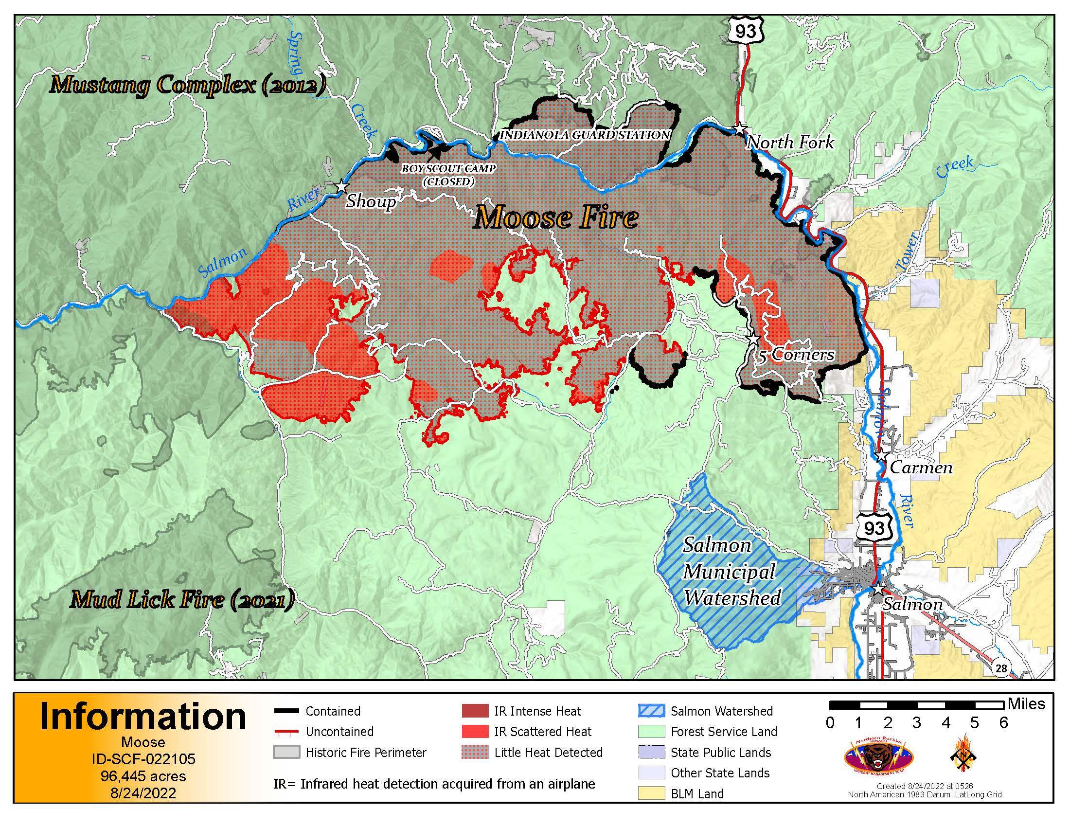
August 31 Moose Fire Daily Update
Related Incident:
Publication Type: News
Fire activity increased north of Bridge Creek Tuesday afternoon due to higher temperatures and lower humidity. Successful operations throughout the day included helicopters assisting firefighters on the ground by dropping buckets of water near Daly Creek and Dump Creek to create black line along the fire’s uncontrolled edge, sprinkler installation and testing near log decks along NF-300, chipping of fuels along Panther Creek Road (NF-055), and extensive scouting for contingency lines led to areas identified for strengthening and tying in with old burn scars. The unmanned aerial system (UAS), or drone, continues to be an important tool in surveying areas difficult for firefighters to access.
Today, firefighters will continue patrolling both sides of the fire’s edge in search of hotspots, fortifying hose lays near log decks, engaging the fire directly along Moose Creek, and protecting structures in the Diamond subdivision and Jesse Creek as fire behavior dictates, as well as along Panther Creek and Trail Creek areas. Suppression repair work has begun in areas where the fire has been contained.
Highway 93, Salmon River Road (NF-030), and Panther Creek Road are open. Travelers on all area roads should remain alert for fire equipment working in the area, and for possible rockfalls. Temporary, short-duration traffic delays are possible.
WEATHER and FIRE BEHAVIOR: The ridge of high pressure continues to strengthen over the fire area, causing temperatures to warm into the 90s to low 100s in the valley, and in the mid-70s to mid-80s in the higher terrain. When high temperatures, low relative humidity, and extremely low fuel moistures align with increased winds, increased fire behavior is expected and more smoke is likely to be visible over the next several days.
EVACUATIONS: All zones are in “READY” status, as determined by the Lemhi County Sheriff’s Office. Details at: https://bit.ly/LemhiCountyEvacs
CLOSURES AND RESTRICTIONS: A Salmon-Challis National Forest closure order issued on August 17 remains in effect for certain roads, trails, and a defined geographic area around the fire. Moose Fire Emergency Area, Road, and Trail Closure, Order #04-13-22-507 . This closure applies to hunting access, firewood cutting and gathering, fishing, hiking, camping, and other recreational activities. Firewood permits and additional details are available at Salmon-Challis NF offices.
August 30 Moose Fire Daily UPdate
Related Incident:
Publication Type: News
Wind at higher elevations within the fire perimeter increased fire activity in Hornet, Arnett, and Daly Creeks, as well as in the headwaters of the Beaver Creek drainage. Heavy helicopters supported crews on the ground with bucket drops on hot spots. The unmanned aerial system was able to provide “eyes in the sky” and guide ground resources into some hot spots that would have otherwise been difficult to detect.
Today, firefighters will work on structure protection of residences in the Beaver Creek valley bottom and fuel reduction activities along the power transmission line will continue. The Salmon River Road is still experiencing some rock and debris fall from the burned area in the steep breaks above the road; firefighters will continue to patrol and clear NF-030. Fire personnel will begin reassessing contingency lines in the area south of the fire perimeter.
Highway 93, Salmon River Road (NF-030), and Panther Creek Road (NF-055) are open. Travelers on all area roads should remain alert for fire equipment working in the area, and for possible rockfalls. Temporary, short-duration traffic delays are possible.
Firewood will be available for public cutting along Anderson Mtn. Road outside Gibsonville, and along both Baldy Mtn. Road and Perreau Creek Road while Ridge Road remains closed. A permit is required, and details are available at Salmon-Challis NF offices.
WEATHER and FIRE BEHAVIOR: A ridge of high pressure is the dominant pattern causing temperatures to warm into the mid-90s in the valley and mid-80s in the higher terrain. Relative humidity values are very low, keeping fuel moistures low and receptive to increased fire behavior.
EVACUATIONS: All zones are in “READY” status, as determined by the Lemhi County Sheriff’s Office. Details at: https://bit.ly/LemhiCountyEvacs
CLOSURES AND RESTRICTIONS: A Salmon-Challis
National Forest closure order remains in effect for certain roads, trails, and a defined geographic area around the fire. Moose Fire Emergency Area, Road, and Trail Closure, Order #04-13-22-507 , issued August 17. This includes being closed to hunting access.
August 29 Moose Fire Daily Update
Related Incident:
Publication Type: News
Yesterday afternoon a hotshot crew, supported by water buckets from a heavy helicopter, worked to contain two spots ahead of the main fire edge in the Daly Creek area. Elsewhere across the fire, personnel and equipment continued to hold and improve containment lines, mop up in areas interior to the firelines, and improve contingency lines on the south side of the fire.
Today firefighters will continue their work on active areas of the fire using both direct and indirect tactics; particularly in the Daly Creek, Dump Creek, and Hornet Creek areas, and portions of the 300 Road. Personnel will also continue fuel reduction work along the power transmission line serving area mines. In less active areas of the fire, crews and engines will continue to patrol, backhaul equipment, and implement suppression repair work. Helicopters are available to assist ground personnel as needed.
Great Basin Incident Management Team 5 assumed command of the Moose Fire today at 6:00 am from Northern Rockies Team 2. The incident objectives are unchanged, and emphasize: -firefighter and public safety; -reducing the negative impacts of fire on communities, infrastructure, municipal watershed, private lands, and other values at risk; -fostering relationships with the public, cooperators, and stakeholders; and -providing timely and accurate information to the public and partners.
Highway 93, Salmon River Road (NF-030), and Panther Creek Road (NF-055) are open. Travelers on all area roads should remain alert for fire equipment working in the area, and for possible rockfalls. Temporary, short-duration traffic delays are possible.
Moose Fire Daily Update for Sunday 28 2022
Related Incident:
Publication Type: News
HighlightsYesterday afternoon’s cold front brought winds with gusts above 40 mph and humidity as low as 8% on portions of the fire. Fire activity and smoke increased significantly in several parts of the uncontained portions of the fire and also in interior pockets of unburned fuels; including in the Upper Beaver, Bridger, Arnett, Daly, and Hot Springs Creek areas. Crews and a helicopter quickly contained several small spot fires within the main containment line.Today firefighters will continue to work in active areas of the fire using both direct and indirect tactics with hand crews, heavy equipment, and chippers. Personnel will also continue fuel reduction work under the power transmission line serving area mines. This work will be ongoing for the next several days. In less active portions of the fire, crews and engines will patrol, backhaul unneeded equipment, and begin implementing suppression repair work. Helicopters are available to assist ground personnel as needed.Highway 93, Salmon River Rd (NF-030), and Panther Creek Rd (NF-055) are open. Travelers on all area roads should remain alert for firefighters and fire equipment working in the area, and for possible rockfalls. Temporary, short-duration traffic delays are possible.Firewood will be available for public cutting along Baldy Mtn Rod and Perreau Creek Road while Ridge Road remains closed due to ingress-egress issues. North of Salmon near Gibbonsville, the Anderson Mtn Road will also be open for public cutting. A permit and load tickets are required. Information is available at Salmon-Challis NF offices.Great Basin Incident Management Team 5 will take over command of the Moose Fire on Monday, August 29, at 6:00 am. Northern Rockies Team 2 appreciates the opportunity to have served local citizens and area visitors for the past two weeks, especially the excellent working relationships with many local and state agency cooperators.
WEATHER and FIRE BEHAVIOR: Winds today will be 10-15 mph, much reduced from Saturday. Temperatures will range from 65-75 on ridgetops to 80-90 in lower elevations. Humidity may drop below 20 percent. Dry and increasingly hot weather is expected over the next several days.
EVACUATIONS: The status of all evacuation zones has been reduced to “READY” by the Lemhi County Sheriff’s Office. Current information is on the Sheriff’s Office website: https://bit.ly/LemhiCountyEvacs
CLOSURES AND RESTRICTIONS: A Salmon-Challis National Forest closure order remains in effect for certain roads, trails, and a defined geographic area around the fire. The Moose Fire Emergency Area, Road, and Trail Closure; Order #04-13-22-507; was issued August 17.
INCIDENT STATISTICS
Size: 96,821 acres
Containment: 44 %
Start Date: July 17, 2022
Total Personnel: 757Cause: Human caused, under investigation
Resources: 12 crews, 6 helicopters, 31 engines and 37 pieces of heavy equipment.
Moose Fire Daily Update for Saturday August 27
Related Incident:
Publication Type: News
Highlights
Yesterday fire crews concentrated on areas of the fire experiencingincreasing fire behavior. Hot Springs Creek, above Panther Creek, was holding significant heat required bucket drops late in the afternoon. The fire was also active in areas near Arnett Creek and Moose Creek. Today firefighters look for these areas to be active.Crews will continue their work along the 53 Road to Leesburg with hand crews, heavy equipment, and chippers. This work will continue over the next several days. Night Shift will continue, and adjustments will be made as the fire dictates.Yesterday the Lemhi County Sheriff’s Department released a new evacuation order. All zones have been lowered to “READY” status. We encourage folks to be vigilant and continue to monitor the fire situation.Firewood will be available for public cutting along Baldy Mountain Road and Perreau Creek Road while Ridge Road remains closed due to ingress-egress issues. North of Salmon outside Gibbonsville, Anderson Mountain Road will also be open for public cutting.We encourage travelers to remain focused and be aware that debris may continue to fall on roads which could lead to possible delays. Anyone traveling the Salmon River Road is encouraged to give themselves some extra time to drive through this area.
WEATHER and FIRE BEHAVIOR: A cold front passes through the area today bringing strong, gusty southwesterly winds and the potential for isolated showers or thunderstorms in the afternoon and early evening, A RED FLAG WARNING is in effect from 3PM to 8PM today. During this period, high winds and very low humidities are expected. Strong winds can cause vast changes in rate, spread, and growth of a wildfire. Managing the fire with these winds and low humidities will be the challenge for firefighters today. Areas holding heat will be closely monitored today.
EVACUATIONS: The Lemhi County Sheriff’s Department has lowered all zones to “READY” status this morning. https://bit.ly/LemhiCountyEvacs
CLOSURES AND RESTRICTIONS: A Salmon-Challis National Forest closure order remains in effect for the Moose Fire Emergency Area, Road, and Trail Closure, Order #04-13-22-507
INCIDENT STATISTICS
Size: 96,681 acres
Containment: 42 %
Start Date: July 17, 2022
Cause: Human caused, under investigation
Total Personnel: 777 Resources: 11 crews, 6 helicopters, 33 engines and 39 pieces of heavy equipment.
Moose Fire Daily Update for Friday August 26 2022
Related Incident:
Publication Type: News
Highlights
Yesterday the Trail Creek area saw active fire behavior prompting air support to assist in addressing hot spots. The Salmon River Road is open to public traffic and remains in patrol status with mop-up efforts continuing.In the coming days crews will work to mitigate areas affected by suppression efforts. Some roads within the closure area remain closed while this work is being completed. Two of these roads are Stormy Peak Road and Diamond Creek Road. Both of these roads are very narrow, steep, and have several switchbacks making it impossible for turn-arounds. Fire traffic is currently heavy on both of these roads. Crews driving heavy equipment, pulling out hoses and backhauling equipment, along with hauling out suppression damaged timber, make these roads unsafe for public use.Heavy equipment will be working under powerlines for several days along the 53 Road to Leesburg. Please use caution when traveling in this area.Firewood will be available for public cutting along Baldy Mountain Road and Perreau Creek Road while Ridge Road remain closed due to ingress-egress issues. North of Salmon outside Gibbonsville, Anderson Mountain Road will also be open for public cutting.We would encourage travelers to remain focused and be aware that debris may continue to fall on roads which could lead to possible delays. Anyone traveling the Salmon River Road is encouraged to give themselves some extra time to drive through this area.
WEATHER and FIRE BEHAVIOR: Dry air will be moving into the region today only allowing for afternoon cumulus clouds to develop. The drier air should limit the humidity recoveries tonight along the mid slope into the high ridges. A cold front will pass through the area on Saturday bringing strong and gusty southwesterly to westerly winds and the potential of an isolated shower or thunderstorm during the afternoon and evening.Fire in Salmon River and Panther Creek drainages will continue to fill in unburned pockets. Fire behavior in Upper Trail Creek and Arnett Creek should decrease as it runs into the old Clear Creek Fire footprint.
EVACUATIONS: Zones 1, 2, 3,4, 7, 9b, 10, 15 are in “READY” status. Zones 8, 9a, 14 are in “SET” status Click here for the latest updates.
CLOSURES AND RESTRICTIONS: A Salmon-Challis National Forest closure order remains in effect for the Moose Fire Emergency Area, Road, and Trail Closure, Order #04-13-22-507
Temporary Flight Restriction (TFR): Reduced this morning and is reflected in the maps
INCIDENT STATISTICS
Size: 96,681 acres
Containment: 41 %
Start Date: July 17, 2022
Cause: Human caused, under investigation
Total Personnel: 792 - Resources: 11 crews, 6 helicopters, 36 engines and 41 heavy equipment.
Moose Fire Daily Update for Thursday August 25
Related Incident:
Publication Type: News
Highlights Given the success of the strategic firing operation on Tuesday afternoon at the banks of the Salmon River and Panther Creek, crews experienced a calmer day on the fire. The firing operation resulted in consumption of ground fuels, aiding the firefighters’ actions of keeping fire from crossing the road. Both roads are in good condition, prompting Forest officials to decide last evening to reopen the Salmon River Road this morning at 6AM and keep it open to the public. We would encourage travelers to remain focused and be aware that debris may continue to fall on the road which could lead to possible delays. Anyone traveling the Salmon River Road is encouraged to give themselves some extra time to drive through this area. Some fire activity was seen in a few areas yesterday. Upper Trail Creek, Arnette, and Upper Beaver Creek all showed an increase in fire behavior although no values were threatened in any of these areas Indirect containment lines between Moose Creek, Jureano Mountain, down to Panther Creek and Leesburg south toward Moccasin are in progress.
WEATHER and FIRE BEHAVIOR: Isolated showers and thunderstorms are expected again during the afternoon and evening hours. Generally increasing winds could increase fire activity. Temperatures will be slightly cooler. Drier air will be moving into the area later in the week.
EVACUATIONS: Zones 1, 2, 3,4, 7, 9b, 10, 15 are in “READY” status Zones 8, 9a, 14 are in “SET” status Click here for the latest updates.
CLOSURES AND RESTRICTIONS: A Salmon-Challis National Forest closure order remains in effect for the Moose Fire Emergency Area, Road, and Trail Closure, Order #04-13-22-507 Temporary Flight Restriction (TFR): There is a flight restriction over the fire area and drones are also prohibited. Thank you for respecting the TFR. If you fly, we can’t fly. https://tfr.faa.gov/
Moose Fire Daily Update for Wednesday August 24 2022
Related Incident:
Publication Type: News
Highlights Yesterday afternoon the Trinity Hotshots and the Bonneville Hotshots combined efforts in a very successful strategic firing operation at the confluence of the Salmon River and Panther Creek on the northwestern side of the fire. An Unmanned Aviation System (UAS) assisted with aerial ignition on the ridgeline. As the fire burned down the ridge the hotshot crews met it as it approached the Salmon River Road and Panther Creek Road. Night crews continued to monitor and work this area throughout the evening. This work will continue today. The closed portion of the Salmon River Road from Spring Creek to Panther Creek will be open from 6AM to 1PM. In order to make it through the road, travelers are advised to leave North Fork by no later than 12:30PM. Panther Creek Road will continue to be open with possible sort-term delays as crews work in this area. Across the southern end of the fire, crews are working to construct a primary control line from Leesburg to Jureano Mountain Lookout. Work will continue to establish a contingency line in the Moccasin Road area of the fire. In the Diamond Line area of the fire crews are planning to start pulling hose coinciding with the Lemhi County Sheriffs Departments decision to lower the evacuation status in Zone 1 from “SET” to “READY” this morning
WEATHER and FIRE BEHAVIOR: Temperatures on the ridges will be in the 70s while temperatures in the lower elevations will be in the 90s. Relative humidity will be low. Thunderstorm threats are possible late afternoon and early evening.
EVACUATIONS: Zone 1 has been decreased to “READY” status this morning .Zone 15 has been added to “READY” status. Residents in Zone 8, 9a and 14 remain in “SET” status. Click here for the latest updates. CLOSURES AND RESTRICTIONS: A Salmon-Challis National Forest closure order remains in effect for the Moose Fire Emergency Area, Road, and Trail Closure, Order #04-13-22-507
Moose Fire Daily Update for Tuesday August 23 2022
Related Incident:
Publication Type: News
Highlights
The Salmon River Road will be open to through traffic today from 6:00 AM until 1:00 PM. The road will close at 1:00 PM. Tactical firing operations may be taking place in the afternoon as conditions allow. Front-end loaders will continue to clear debris off of Salmon River Road.
Panther Creek Road may experience short term, intermittent closures throughout the day for tactical firing operations and to allow firefighters room to work safely.
A decision on road closures for tomorrow will be made this evening after reassessing conditions for public safety. We ask that extreme caution be used when traveling these roads in order to maintain public and firefighter safety.
EVACUATIONS:
Please note the following changes to the evacuation plan:
• Zone 14 (Trail Creek north to the confluence of Panther Creek) has been changed to “SET.”
• Zone 9 has been divided into Zone 9A and 9B.
• Zone 9A (Pine Creek bridge down to and including Owl Creek) has been changed to “SET.”
• Zone 9B (west of Cove Creek to west of Ebenezer Campground) remains in “READY.”
• Zone 1 remains in “SET” status.
• All other zones remain in “READY” status.
“READY” means you should create and maintain defensible space to protect your home against flying embers. Other steps include making a family communication plan, sharing phone numbers and contacts, and planning to make accommodations for your pets, prescriptions, papers and priceless possessions.
“SET” means to prepare your family and home ahead of time for the possibility of having to evacuate. Check with hotels, motels and campgrounds to learn if they are open. You should be packed to leave, and prepared to leave at a moment’s notice if you must evacuate.
Click here for the latest updates or visit lemhicountyidaho.org
WEATHER and FIRE BEHAVIOR: There is a chance of afternoon and early evening showers and thunderstorms. Minimum relative humidity values will be in the mid-teens in the Panther Creek/Salmon River drainage to as high as upper 20’s over the ridges. Southwest winds will be 10 – 15 mph over the ridges with gusty winds near thunderstorms. Cloud cover will be present, but reducing. The potential for thunderstorms will be lower, but still present. Downbursts could cause erratic fire movement.
CLOSURES AND RESTRICTIONS: A Salmon-Challis National Forest closure order remains in effect for the Moose Fire Emergency Area, Road, and Trail Closure Order #04-13-22-507
Flood Watch in Effect for Cerro Pelado Burn Scar
Related Incident: Cerro Pelado Post-Fire BAER
Publication Type: News
Flood Watch in Effect for Cerro Pelado Burn Scar
The National Weather Service has issued a Flood Watch for Saturday September 10th in effect from noon MDT through the evening for the Jemez Mountains, including areas burned by the Cerro Pelado Fire. A flood watch remains in effect for the East Slopes and Southern Sangre de Cristo Mountains, including area burned by the Hermits Peak-Calf Canyon Fire.
BAER Safety Message: Everyone near and downstream from the burned areas should remain alert and stay updated on weather conditions that may result in heavy rains and increased water runoff. Flash flooding may occur quickly during heavy rain events. Be prepared to act. Current weather and emergency notification can be found at the National Weather Service website www.weather.gov/abq.