
Bonners Ferry Ranger District Fires Fact Sheer 9022022 Idaho Panhandle NF
Related Incident: Russell Mountain Fire
Publication Type: News
Bonners Ferry Ranger District Fires Fact Sheet
Idaho Panhandle National Forests
Inciweb:
https://inciweb.nwcg.gov/incident/8374/ https://inciweb.nwcg.gov/incident/8338/
https://inciweb.nwcg.gov/incident/8356/ https://inciweb.nwcg.gov/incident/8360/
Facebook:
https://www.facebook.com/USFSIPNF
Public Information Phone: (208) 557-8813
Boundary County Emergency Line: (208) 696-2629
District Fact Sheets will be provided if a significant event occurs.
Location: Bonners Ferry, Idaho
Name of Fire Start Date Size (Acres) Cause Containment
Eneas Peak August 13, 2022 1,123 Lightning 0%
Trout August 21, 2022 678 Lightning 0%
Russell Mountain August 24, 2022 3,107 Lightning 0%
Scotch September 1, 2022 494 Lightning ` 0%
Last night, a reconnaissance flight checked the status of existing fires. The Eneas Peak fire grew 178 acres; the Trout Fire grew 428 acres; the Russell Mountain fire grew 607 acres, and the Scotch fire grew 449 acres. Fire managers continue to assess opportunities to utilize aviation resources to confine all four fires within the drainages and west of the private lands. Engines are working along Westside road to protect private homes, and crews will continue the work into the night.
Closures: Due to fire suppression activities and active fires effect we advise that visitors avoid Ball Creek Road (FSR 432), Trout Creek Road (FSR 634), and trails. Impacted Trails include Russell Mountain (No. 12), Russell Ridge (No. 92), Ball & Pyramid Lakes (No. 43), Pyramid Pass Trail (No. 13), Pyramid Peak (No. 7), Fisher Peak (No. 27), and Trout Lake (No. 41).
Evacuations: There are NO evacuations currently in place. However, those living on West Side Road closest to Burton Road and Ball Creek Road have been upgraded to ‘set’ fire evacuation status. “Set” is the last stage of readiness before an actual evacuation takes place. If not voluntarily evacuating already, residents in this stage are advised to at least gather their evacuation supplies together or pre-load them into their vehicles to enable a quick exit if evacuation is advised. When living in fire-prone areas, all residents must have an evacuation plan, including all essential documents, pictures, prescriptions, and pets, and be quickly transportable. Residents of Boundary County, ID, can visit https://www.nixle.com or text their home zip code to 888777 to sign up for emergency alerts. To learn more about Ready Set Go, visit https://bit.ly/3wi0jMu. For tips on defensible space for homes, visit Firewise https://bit.ly/3PALyeG. To prevent unwanted fires, visit the Idaho Department of Lands https://bit.ly/3c4v158.
###Bonners Ferry Ranger District Fires Fact Sheet 9012022Idaho Panhandle NF
Related Incident: Russell Mountain Fire
Publication Type: News
Bonners Ferry Ranger District Fires Fact Sheet 9/01/2022Idaho Panhandle National Forests
Inciweb: https://inciweb.nwcg.gov/incident/8374/ https://inciweb.nwcg.gov/incident/8338/https://inciweb.nwcg.gov/incident/8356/ https://inciweb.nwcg.gov/incident/8360/ Facebook: https://www.facebook.com/USFSIPNF
Public Information Phone: (208) 557-8813District Fact Sheets will be provided if a significant event occurs.
Location: Bonners Ferry, Idaho
Name of Fire Start Date Size (Acres) Cause Containment
Eneas Peak August 13, 2022 945 Lightning 0%
Trout August 21, 2022 250 Lightning 0%
Russell Mountain August 24, 2022 2,500 Lightning 0%
Scotch September 1, 2022 45 Lightning ` 0%
On Wednesday, a severe weather system developed that brought isolated precipitation and many lightning strikes. Today, a reconnaissance flight checked the status of existing fires. A few new starts from this storm have been confirmed by the Bonners Ferry Ranger District, and crews continue to respond and prioritize resources based on values at risk. The most notable new start Selkirk Mountain is the Scotch Fire; started by lightning and is currently 45 acres in size. The Eneas Peak fire grew 12o acres; the Trout Fire grew 225 acres; and the Russell Mountain fire increased by 2,200 acres. All will be assessed by air and ground resources and remain in a contain and confine management strategy. Aviation resources have been available recently and will continue to be used as necessary to support all fires
Closures: Official Closures are in effect for Ball Creek Road (FSR 432), the Trout Creek Road (FSR 634), and trails due to fire suppression activities and active fires. Impacted Trails include: Russell Mountain (No. 12), Russell Ridge (No. 92), Ball & Pyramid Lakes (No. 43), Pyramid Pass Trail (No. 13), Pyramid Peak (No. 7), Fisher Peak (No. 27), and Trout Lake (No. 41).
Evacuations: There are NO evacuations currently in place. However, when living in fire-prone areas, all residents must have an evacuation plan in place, including having all essential documents, pictures, prescriptions, and pets gathered and quickly transportable. Residents of Boundary County, ID, can visit https://www.nixle.com or text their home zip code to 888777 to sign up for emergency alerts. To learn more about Ready Set Go, visit https://bit.ly/3wi0jMu. For tips on defensible space for homes, visit Firewise https://bit.ly/3PALyeG. To prevent unwanted fires, visit the Idaho Department of Lands https://bit.ly/3c4v158.
###
Russell Mountain Fire Update August 30 2022
Related Incident: Russell Mountain Fire
Publication Type: News
Public Information Phone: (208) 557-8813
District Fact Sheets will be provided if a significant event occurs.Location: Selkirk Mountains – north/northwest of Bonners Ferry, Idaho
Over the last two days all three fires experienced growth with the warmer/drier weather. The Eneas Peak fire grew 23 acres; the Trout Fire grew 6 acres; and the Russell Mountain fire increased by 67 acres. All will be assessed by air and ground, and remain in a contain and confine management strategy. Aviation resources have been available recently and will continue to be used as necessary to support all fires. A high-pressure ridge has moved into the region bringing warmer and drier weather for the week ahead.
Closures:Please avoid the Ball Creek Road (FSR 432), the Trout Creek Road (FSR 634), and trails due to fire suppression activities and active fires.
These trails include:·
Russell Mountain (No. 12), Russell Ridge (No. 92)· Ball & Pyramid Lakes (No. 43), Pyramid Pass Trail (No. 13), Pyramid Peak (No. 7)· Fisher Peak (No. 27)· Trout Lake (No. 41)
###
Russell Mountain Fire Update August 28 2022
Related Incident: Russell Mountain Fire
Publication Type: News
District Fact Sheets will be provided if a significant event occurs.
###
Russell mountain Fire Update August 27 2022
Related Incident: Russell Mountain Fire
Publication Type: News
A low-pressure system moves into the area today and will remain throughout the weekend providing much cooler temperatures and higher humidity levels. Today will be partly cloudy with a chance of rain but breezy winds are a concern for the Panhandle after several days of lightning. The Eneas Peak and Trout Fire have gained little growth over the past 24 hours while the Russell Mountain increased by 34 acres. The Russell Mountain fire, the furthest fire from the valley, is wind and terrain driven. The winds from the west/southwest have pushed the fire further to the east and it is moving upslope in a draw. Firefighters continue to utilize a contain and confine management strategy which may include air support.
Closures:
Russell Mountain Fire Update August 26 2022
Related Incident: Russell Mountain Fire
Publication Type: News
Size: 19 Acres
Containment: 0%
Closure Order Rescinded Dismal and Patrol Point Fires Sept 15 2022
Related Incident: Patrol Point
Publication Type: Closures
The closure order for areas of the Payette National Forest near the Dismal and Patrol Point Fires has been lifted, as of September 15, 2022 at 00:01.
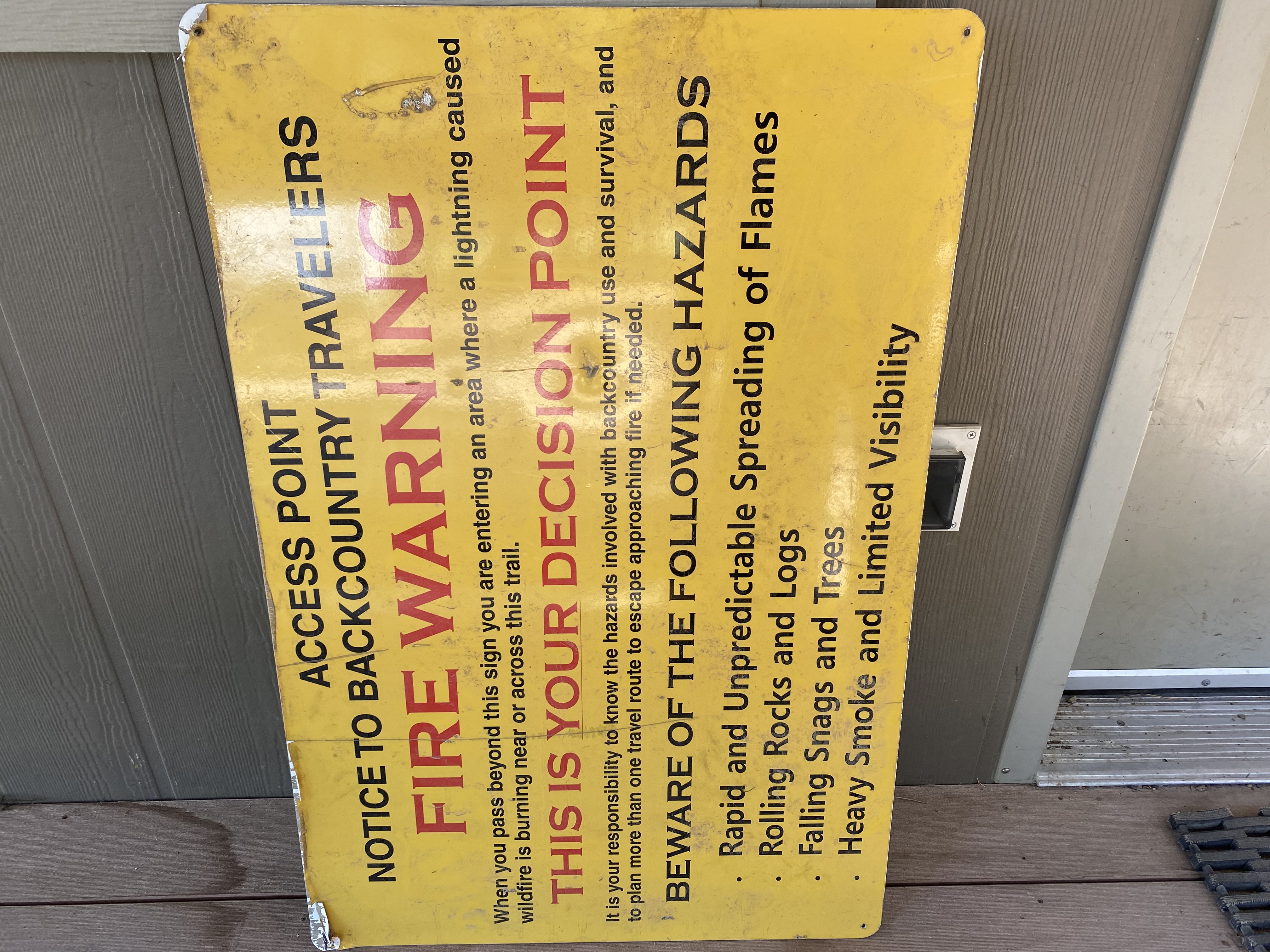
However, there is still fire activity in the area. Backcountry travelers have a responsibility to know the hazards involved with backcountry use and survival, and to plan more than one travel route to escape approaching fire if needed. Beware of the following hazards: rapid and unpredictable spread of flames, rolling rocks and logs, falling snags and trees, heavy smoke and limited visibility.
Closure Order 3 Dismal Fire and the Patrol Point Fire September 7 2022
Related Incident: Patrol Point
Publication Type: Closures
A new Area Closure Order was issued on September 7, 2022 that covers the Dismal Fire and the Patrol Point Fire.
Trout Fire Change
Related Incident: Trout Fire
Publication Type: News
The Trout Fire is now the Kootenai River Complex. Click here for information.
Kootenai River Complex link: https://inciweb.nwcg.gov/incident/8378/
Donation Inquires
Related Incident: Trout Fire
Publication Type: News
Attention, it has come to our attention that there has been social media posts/conversations about donating to the U.S. Forest Service Fire Management Teams. We greatly appreciate the support and generosity of the community, but we ARE NOT accepting or requesting donations! Our team’s focus is on the mission of fire suppression while keeping firefighter and public safety our number one priority. Our wildland fire crews are well equipped and cared for. However if you are interested in showing support below is a list of ways you can support our team and mission:
Here are some ways you can show support for firefighters.
- Help keep firefighters safe by creating defensible space around your home. Creating defensible space around your home is absolutely the BEST thing you can do to help firefighters. Learn how at http://firewise.org.
- Post thank you banners / signs in the community and on social media. This is a great morale booster for firefighters after a long shift!
- Write thank you notes to firefighters. Drop them off at the incident command post so they can be posted or shared.
- Write thank you letters to firefighters families. Put them in blank, stamped envelopes. After briefings or after shifts, firefighters can address letters to parents, kids, spouses, etc.
- , and we have strict national guidelines for firefighter nutrition. Rest assured, we feed our fire crews three meals a day, including snacks.
Consider a financial contribution to a voluntary organization of your choice. You might consider a donation to:
- Your Local Fire Department
- The Wildland Firefighter Foundation or other firefighter support organization
- The American Red Cross or other community relief organization
- Your local Humane Society or other animal support organization
- Other organizations of your choice
Thank you for your kind consideration!