
May 3 Prescribed Fire Operations 05 02 2025
Related Incident: Lolo National Forest Prescribed Fire Operations
Publication Type: Announcement
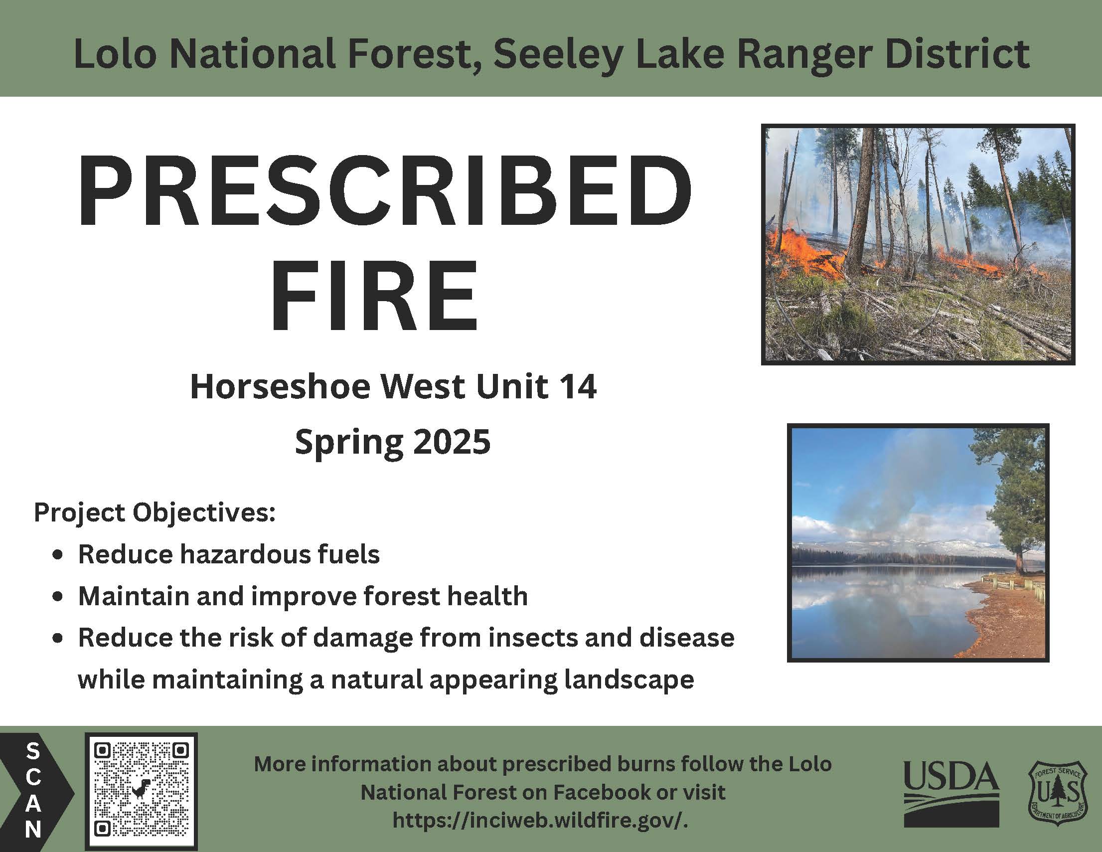
Seeley Lake Ranger District: Firefighters will burn up to 38 acres in the Horseshoe West project area, 4 miles South of Seeley Lake. Minimal smoke impacts are anticipated; however, smoke may be visible from Highway 83 in the Seeley Lake area.
All prescribed burns will be implemented in compliance with Montana air quality standards and coordinated with the Montana Department of Environmental Quality to reduce the impact of smoke on neighbors, cooperators and surrounding communities. Smoke is expected to be a short-duration event and may settle in valley bottoms and drainages overnight and will dissipate within a few days.

Stronghold Fire Update for Friday05 02 2025
Related Incident: Stronghold Fire
Publication Type: News
Summary: Favorable weather conditions overnight, including cooler temperatures and higher relative humidity levels, continue to play a role in minimal fire activity. No additional growth has been reported on the fire over the last few days. The fire is 2,138 acres and 62% contained. This morning, the Cochise County Sheriff’s Office lifted the last remaining SET notifications for the areas south of Ironwood Road and west of Cochise Stronghold Road. All residents are in READY status.
For today’s operational plan, crews will finish up work along the west end of the fire by securing any remaining uncontained line and checking for any potential threats to the line. The north and east sides of the fire are secured, but engines continue patrolling and monitoring that side, serving as a presence within the communities. An Unmanned Aircraft System (UAS) has been supporting the fire by flying infrared (IR) and reconnaissance missions in areas with steep and rugged terrain. The IR flights revealed some hotspots of heavy fuels that continue to smolder, located deep within the fire’s interior. Resources will work on mopping those up today. Firefighter and public safety remain paramount through the duration of the incident as resources work toward full suppression and protection of all values at risk.
Some Stronghold firefighting resources have been designated as Initial Attack for new starts that may occur in the area, within the incident’s designated Temporary Flight Restriction (TFR), as well as outside the TFR as requested by the state and/or Coronado National Forest. Over the next few days, operations will be releasing some resources in order to right size the incident and match the fire’s needs.
Evacuations and Closures: Out of public safety, the Coronado National Forest Douglas Ranger District has implemented a Temporary Occupancy and Use Area Order due to the Stronghold Fire: https://www.fs.usda.gov/r03/coronado/alerts/stronghold-fire
Weather: Hot, windy, and dry conditions remain a concern for fire operations. Weather pattern shifts this weekend could bring critical fire weather during a wind event.
Safety: Due to aircraft use, a TFR (Temporary Flight Restriction) is in place over the fire. Firefighting aircraft and drones are a dangerous combination. Drones in the area could lead to accidents or slow down wildfire suppression operations. If you fly…we can’t.
Black Swamp Fire Update05 02 2025
Related Incident: Black Swamp Fire
Publication Type: News
NEW BERN, N.C., May 2, 2025 – The Black Swamp Fire remains at 950 acres and 60% contained as suppression efforts continue in the Croatan National Forest.
Personnel from five agencies—USDA Forest Service, North Carolina Forest Service, U.S. Fish and Wildlife, North Carolina Wildlife Resource Commission and the National Park Service—are working together on the incident, with more than 80 responders assigned.
Infrared mapping tools used by helicopter pilots show underground heat within containment lines. Several internal pockets of flames flared up and were quickly extinguished by helicopter bucket drops. Firefighters are flooding the smoldering organic material using a system of canals, pumps and sprinklers. Crews are exercising extra caution as they carefully monitor and mop up to ensure that flames do not jump containment lines.
Firefighters responded to another fire south of Havelock, North Carolina, off Highway 70, on Forest Service land. The fire spread to the western side of the train tracks, but thanks to quick response actions, initial attack was able to contain the Train Tracks Fire at 2 acres and will work to completely extinguish the fire while suppression efforts continue on the Black Swamp Fire.
Closures remain in effect for Black Swamp Road, the Black Swamp OHV area, Great Lake Boating Access Area and Sheep Ridge Wilderness Area, as well as portions of Great Lake Road, Seaborn Road and Holston Hunter Road.
Smoke from the fire can cause limited visibility and may impact local air quality. Please drive slowly and use caution on roads where smoke may be settling. Check for air quality alerts at https://airquality.climate.ncsu.edu/ or https://fire.airnow.gov.
For the latest wildfire updates, follow the National Forests in North Carolina on Facebook at U.S. Forest Service - National Forests in North Carolina or visit https://www.fs.usda.gov/r08/northcarolina.
Stronghold Fire Update for Thursday05 01 2025
Related Incident: Stronghold Fire
Publication Type: News
Summary: Despite weather and topography challenges, crews continue to make good progress on the fire. With an increase in containment on Wednesday, today, the Cochise County Sheriff’s Office reduced the GO status for some residents impacted by the fire. This morning, the Sheriff’s Office lifted the GO status and returned residents to SET in the areas south of Ironwood Road and west of Cochise Stronghold Road. All residents in SET have returned to READY.
For the second night in a row, the Stronghold Fire stayed within its fire footprint. Resources on a night shift reported very minimal fire activity. The night shift maintained a presence in nearby communities by patrolling and monitoring the fire’s edge. An infrared flight conducted on Wednesday confirmed the acres at 2,138. The fire is now 54% contained.
Aircraft continues to support the Stronghold Fire and on Wednesday it was utilized as logistical support to sling water, food, and other supplies to crews working in the inaccessible terrain. Due to the aircraft usage, a Temporary Flight Restriction (TFR) was put into effect within the first few hours of the fire’s start. Over the last few days, two incursions within the TFR have been reported to Air Operations. Any incursion in the airspace from aircraft or Unmanned Aircraft Systems (UAS) pose a serious threat to air and ground resources. Often times, if an incursion occurs, suppression operations can come to a halt as aircraft supporting the incident must be grounded and ground resources pulled off the fireline.
For today’s operations, resources assigned to the north and east sides of the fire will continue to patrol and monitor within those areas, checking for any interior smokes or potential threats to the line in anticipation of this weekend’s forecast critical fire weather. Along the east flank, hand crews previously completed and secured the hand line from Ironwood and Cochise Stronghold Roads south to Highland Road. Along the southwest side, fire activity has decreased, but it remains hung up within the Dragoons in rocky and inaccessible terrain. The southeast side within Grapevine Canyon consists of similar terrain. Hotshot and hand crews are working in those areas and will finish putting line in along the ridgelines and where it is safe to do so. They will also monitor and respond to any hotspots or rollouts. Today, resources will expand the contingency line on the south side and tie it into Middlemarch Road. Firefighters are using direct, indirect, and point protection tactics to fully suppress the fire. Engine resources remain engaged, patrolling and monitoring the fire’s perimeter, and extinguishing any hot spots along the edge. The Stronghold Fire is a full suppression fire with incident objectives including firefighter and public safety, structure and infrastructure protection, and watershed and wildlife protection. Some Stronghold Fire resources will be designated as Initial Attack to any new starts that may occur in the area over the next few days.
Out of public safety, the Coronado National Forest Douglas Ranger District has implemented a Temporary Occupancy and Use Area Order due to the Stronghold Fire: https://www.fs.usda.gov/r03/coronado/alerts/stronghold-fire
Evacuations and Closures: SET: south of Ironwood Road and West of Cochise Stronghold Road. For additional updates on evacuations, check with the Cochise County Sheriff’s Office.
Weather: Hot, windy, and dry conditions remain a concern for fire operations. Weather pattern shifts this weekend could bring critical fire weather during a wind event.
Safety: Due to aircraft use, a TFR (Temporary Flight Restriction) is in place over the fire. Firefighting aircraft and drones are a dangerous combination. Drones in the area could lead to accidents or slow down wildfire suppression operations. If you fly…we can’t.
Black Swamp Fire Update 05 01 2025
Related Incident: Black Swamp Fire
Publication Type: News
NEW BERN, N.C., May 1, 2025 – The Black Swamp Fire held at 950 acres with 60-percent containment overnight thanks to the ongoing suppression efforts on the Croatan National Forest.
Eighty personnel from the USDA Forest Service, North Carolina Forest Service, U.S. Fish and Wildlife, North Carolina Wildlife Resource Commission, and the National Park Service are assigned to the fire.
Wildland firefighters continue to use a variety of methods to combat the flames in the dense, swampy terrain. The objective remains to keep safety first and fight the fire aggressively as the southerly winds and sea breeze drive the fire. Firefighters will continue to soak spot fires and mop up within the containment lines as well as clear snags along Black Swamp Road. High-volume pumps and large sprinklers are drenching the smoldering and highly flammable peat and organic soil. Helicopters are supporting in suppression efforts by dumping between 650 and 800 gallons of water per bucket drop on the flames and cooling pockets of heat. Firefighters are deploying dozers, low ground pressure equipment, and hand tools to reinforce containment lines. Additional equipment and personnel have been ordered.
Closures remain in effect for Black Swamp Road, the Black Swamp OHV area, Great Lake Boating Access Area, Sheep Ridge Wilderness Area, and portions of Great Lake Road, Seaborn Road and Holston Hunter Road.
Smoke from the fire can cause limited visibility and may impact local air quality. Please drive slowly and use caution on roads where smoke may be settling. Check for air quality alerts at https://airquality.climate.ncsu.edu/ or https://fire.airnow.gov.
For the latest wildfire updates, follow the National Forests in North Carolina on Facebook at U.S. Forest Service - National Forests in North Carolina or visit https://www.fs.usda.gov/r08/northcarolina.
Mary 2 Prescribed Fire Operations 05 01 2025
Related Incident: Lolo National Forest Prescribed Fire Operations
Publication Type: Announcement
Fire officials on the Lolo National Forest may implement prescribed fire operations today, as weather and fuels conditions allow.
Ninemile Ranger District: Firefighters may burn up to 32 acres in the Frenchtown Face project area, 2 miles North of the District Office. Smoke may be visible from Huson.
Firefighters may also burn up to 68 acres in the South Fork Fish project area, 9.5 miles northwest of Lolo Hot Springs. Smoke may be visible from Lolo Hot Springs and surrounding areas.
Superior Ranger District: Firefighters will burn up to 15 acres in the South Fork Tamarack Creek area, 5 miles North of St. Regis. Minimal smoke impacts are anticipated; however, smoke may be visible from Interstate 90 in the St. Regis area (see map below).
Plains/Thompson Falls Ranger District: Firefighters plan to conduct up to 50 acres of understory burning on the Two Short unit 22, six miles west of Thompson Falls. Smoke may be visible from Thompson Falls.
All prescribed fires are implemented in compliance with Montana air quality standards and coordinated with the Montana Department of Environmental Quality and the appropriate county health departments to reduce the impacts of smoke to neighbors, cooperators, and surrounding communities. For additional information on air quality, smoke management, and forecasts, see https://mi.airshedgroup.org/.
For more information on prescribed fire and fuels management on the Lolo National Forest visit: https://www.fs.usda.gov/r01/lolo/fire/prescribed-fire.
Haycamp Mesa Prescribed Fire Postponed Date posted 05 02 2025
Related Incident: 2025 San Juan National Forest Prescribed Fire Program
Publication Type: Announcement
A prescribed burn in the Haycamp Mesa area, approximately 8 miles east-northeast of Dolores, CO, which was scheduled for May 2nd, has been postponed. After conducting a test fire, it was determined that conditions were too wet for a successful burn. This page will be updated when the planned burn is rescheduled.
The targeted area is the northern portion of Unit 8 (north of 492 Rd, see attached map) about 537 acres. The area is within Montezuma County, consists of ponderosa pine and Gambel oak fuels.
Settings - change map background and toggle additional layers
Filter - control incident types displayed on map.
Zoom to your location
Reset map zoom and position
Could not determine your location.
Show Legend
 Wildfire
 Prescribed Fire
 Burned Area
Response
Burned Area
Response Other
Other
Little Dean 724 Prescribed Burn
Unit Information
Incident Contacts
Settings - change map background and toggle additional layers
Filter - control incident types displayed on map.
Zoom to your location
Reset map zoom and position
Could not determine your location.
Show Legend
- Wildfire
- Prescribed Fire
- Burned Area
Response
- Other
Starvation 9 Prescribed Burn
Unit Information
Incident Contacts
Coronado National Forest Douglas Ranger District Stronghold Wildfire Temporary Occupancy and Use Area Order 04 30 2025
Related Incident: Stronghold Fire
Publication Type: Closures
The U.S. Forest Service Coronado National Forest's Douglas Ranger District issues a Temporary Occupancy and Use Area Order