
Incident Publication
Daily Fire Update 08222021
Related Incident:
Publication Type: News
American Fork, Balsinger and Woods Creek Fires Update
Sunday, August 22, 2021 – 10:00 a.m.
Rocky Mountain Type 1 Incident Management Team
Dan Dallas, Incident Commander
Information phone: 406-426-9612
Email: 2021.divide@firenet.gov
Information staffing hours: 8:00 am – 8:00 pm
Special Notes: Tonight at 8pm, the Fire Department of New York (FDNY) Type 2 Incident Management Team will assume command of the Balsinger and Woods Creek Fires. The Albuquerque Zone Type 3 Incident Management Team will assume command of the American Fork Fire.
Current Situation: Cool, wet weather continues to limit fire behavior. Firefighters are strengthening containment and contingency lines and working to add containment on the Woods Creek and American Fork fires. Due to more accurate mapping, the acreage estimates for the Balsinger and Woods Creek Fires are slightly different today.
American Fork Fire
Acreage: 21,876 | Containment: 57% | Start date: July 17, 2021 | Cause: Lightning | Personnel: 132
The American Fork Fire is burning in the central part of the Crazy Mountains, approximately 24 miles southwest of Harlowton, Montana. On the east side of the fire, crews in Division A are working with engines to contain the remaining line near the Middle Fork American Fork Creek. The southeast portion of the fire is in patrol status. In Division P, firefighters will continue constructing direct fire line from Buck Creek Road, working east. Engines and crews are improving containment lines. There has been no change in the fire perimeter for ten days on the west side. They are backhauling pumps, tanks, and equipment around structures. In the northern part of Division P, firefighters are using direct attack to tie into the roadless area to the north. Work continues in the Dugout Creek area of Division M with firefighters anchoring to the containment edge constructing line to the east. There is very little heat in the Lebo Fork area in Division M and there has been no fire growth for several days. Crews are looking at options to connect fireline in this area with the Blacktail Fire scar.
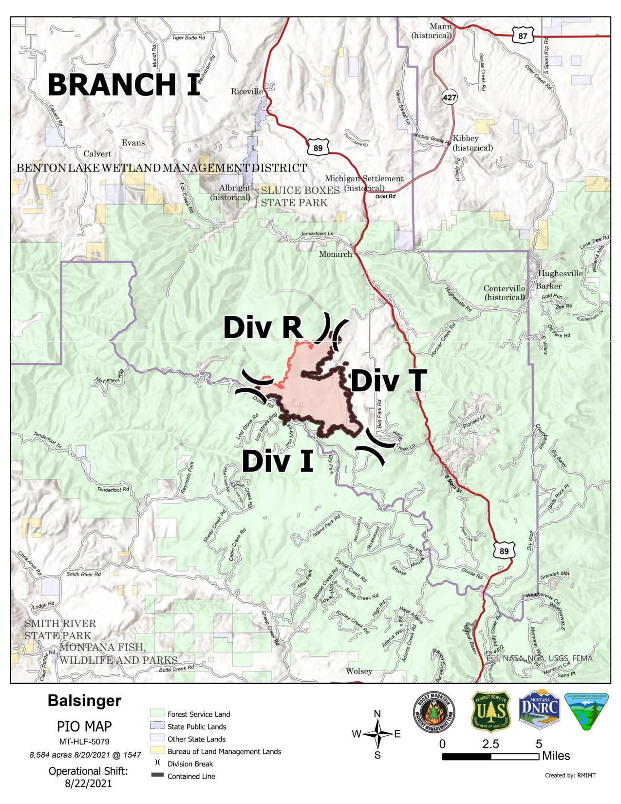
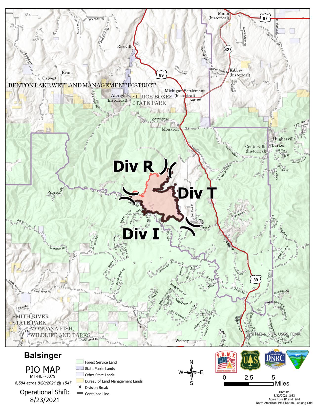
Balsinger Fire
Acreage: 8,584 | Containment: 77% | Start date: July 9, 2021 | Cause: Lightning | Personnel: 68
The Balsinger Fire is in the Little Belt Mountains, approximately five miles west of Neihart, Montana. Firefighters yesterday patrolled and mopped up along containment lines, addressing any hot spots. Today they will continue adding depth to the line in Division I on the west side of the fire. Firefighters are working throughout the eastern edge of the fire in Division T, increasing depth on the containment line. Fire officials are analyzing the north edge of the fire in Division R, formulating a longer term management plan. Backhauling continues today, retrieving hoses and equipment to be cleaned and refurbished.
Woods Creek Fire
Acreage: 55,882 | Containment: 52% | Start date: July 10, 2021 | Cause: Lightning | Personnel: 562
The Woods Creek Fire is burning in the Big Belt Mountains, approximately 16 miles northeast of Townsend, Montana. A hotshot crew continues to mop up and strengthen containment line at the north edge of the fire in Divisions YY and AA. Most of the eastern edge of the fire, in Divisions AA and OO, is in patrol status. Control line is in place, but some heat remains in the drainage near Big Birch Creek. Firefighters are working to fully contain that edge. Another hotshot crew directly engaged a spot fire yesterday near Russell Fork Deep Creek. The UAS (firefighting drone) had flown over the area and provided data on the terrain, fire behavior, and hot spots. In Division QQ, firefighters are working near Gurnett Creek to add containment. Crews in Division SS are patrolling, mopping up, and improving contingency lines. A hotshot crew is working to add containment near Horse Creek. Direct attack continues in Division YY near North Fork Duck Creek.
Weather and Fuel Conditions: During the day, storms barely clipped the Balsinger and Woods Creek Fires. Overnight there were additional storms with 45 mph wind gusts and rain on all three fires. Today and tomorrow will see strong westerly winds at a sustained 18-24 mph with gusts up to 40 mph. It will remain cooler and more humid than usual for this time of year, with a 10% chance of rain. The high temperature today will be 58°F at 7500 feet elevation. Fire behavior is currently moderated by the wet fuels and weather conditions. Long-term fire modeling shows a low probability of major fire spread.
Evacuation Notices
The interactive web map depicts evacuation areas. Please see https://bit.ly/WoodsCreekBalsingerAmericanForkFires or contact your local county sheriff’s office for details.
American Fork Fire: The Park County Sheriff’s Office has Shields River Road in pre-evacuation status. Meagher County has done the same with the Smith Creek area. County roads in the area are open. However, there are still closures in the National Forests.
Balsinger Fire: The Cascade County Sheriff’s Office has issued pre-evacuation orders for Belt Park, the area from the Belt Creek Ranger Station to Monarch, and from west of Monarch to the confluence of Pilgrim Creek and Belt Creek.
Woods Creek Fire: Effective August 20, the Broadwater County Sheriff’s Office lifted all evacuation and pre-evacuation orders and warnings for all areas of the Woods Creek Fire on the Broadwater County side.
Effective August 18, the Meagher County Sheriff’s Office has lifted the pre-evacuation for the area east of Camas Creek Road and north of North Fork Woods Gulch Creek to Luppold Road. On the east side of the fire, the area south of Burt Ranch Road and west of Camas Creek Road has been moved from mandatory to pre-evacuation status. A pre-evacuation notice remains in place for residents on Birky Road and Ramspeck Lane and for Grassy Mountain residents.
Closures and Advisories
Areas around the fires are closed for public safety. Please respect the closure signs.
Temporary flight restrictions (TFRs) remain in place on the Woods Creek and American Fork fire areas. TFR violations can disrupt aerial firefighting operations and may force fire managers to ground essential aircraft. Wildfires are a no-fly zone for unauthorized aircraft, including drones. If you fly, we can’t. http://knowbeforeyoufly.org
Most of the Helena-Lewis and Clark National Forest is in Stage 2 fire restrictions. There are also closure areas for the Balsinger and Woods Creek fires. See: https://www.fs.usda.gov/alerts/hlcnf/alerts-notices
Stage 1 fire restrictions remain in place for the Custer Gallatin National Forest. There is also a closure area for the American Fork fire. See: https://www.fs.usda.gov/alerts/custergallatin/alerts-notices
The Bureau of Land Management Butte and Lewiston Field Offices issued an area closure for lands affected by the Woods Creek Fire. See: https://inciweb.nwcg.gov/incident/article/7649/63667/
WoodsCreekBalsingerAmericanForkFires Interactive Map has been disabled
Related Incident:
Publication Type: Announcement
#WoodsCreekBalsingerAmericanForkFires Interactive Map has been disabled.
Information is still available through Inciweb, https://inciweb.nwcg.gov/, and daily updates posted to the Facebook page https://bit.ly/2XiK1Et. The Interactive Map has been disabled as part of the Incident Management Team transition from the Rocky Mountain Type 1 Team to the Fire Department of New York, (FDNY) Type 2 Incident Management Team and the Albuquerque Zone Type 3 Team Incident Management Team. Once there are no additional mapping data changes planned, webpage links may be disabled to minimize the spread of outdated information and avoid confusion.
Daily Fire Update 08232021
Related Incident:
Publication Type: News
American Fork, Balsinger and Woods Creek Fires Update
Monday, August 23, 2021 – 10:00 a.m.
Albuquerque Zone Type 3 Incident Management Team
Zach Saavedra, Incident Commander – American Fork Fire
Fire Department City of New York Type 2 Incident Management Team
Richard DePrima, Incident Commander – Balsinger and Woods Creek Fires
Information phone: 406-426-9612
Email: 2021.divide@firenet.gov
Information staffing hours: 8:00 am – 8:00 pm
Special Notes: The interactive web map of the three fires is now disabled. Please see the maps of each fire attached to these daily updates or on the Facebook or InciWeb sites.
Current Situation: Cool, wet weather continues to limit fire behavior. Firefighters are strengthening containment and contingency lines and working to add containment on the Woods Creek and American Fork fires. Suppression repair and backhauling continue, mitigating damage to natural and cultural resources and preparing equipment for its next use.
American Fork Fire
Location: 24 miles SW of Harlowtown, MT | Acreage: 21,876 | Containment: 58% | Start date: July 17, 2021
Cause: Lightning | Personnel: 132
The American Fork fire was transitioned to the Albuquerque Zone - Type 3 Incident Management Team (IMT) on August 22. The Albuquerque Zone - Type 3 team arrived at the incident on August 21 and received a thorough in-briefing from the outgoing Incident Management Team - Type 1 and the incoming Fire Department City of New York (FDNY) - Type 2 IMT. The FDNY team will continue to manage the Woods Creek and Balsinger fires. The Albuquerque Zone - Type 3 Operations Branch Section Chief, Marc Wheeler, in collaboration with the Incident Commander and outgoing team, prioritized resources and manageable span of control. This was done to downsize the organization to meet all operational needs and optimal effectiveness to carry forward the mission of full suppression.
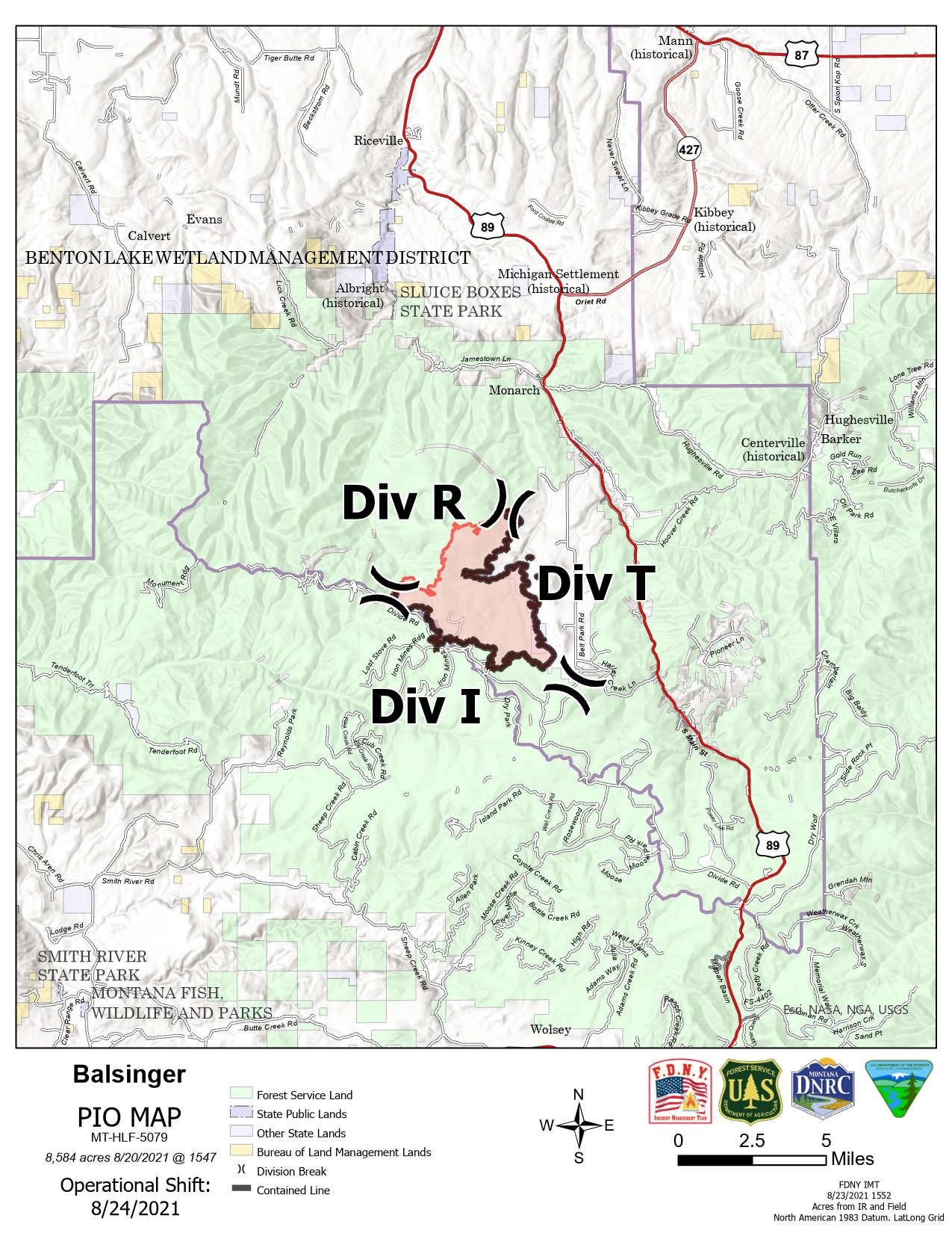
Balsinger Fire
Location: 5 miles W of Neihart, MT | Acreage: 8,584 | Containment: 77% | Start date: July 9, 2021
Cause: Lightning | Personnel: 69
Firefighters yesterday patrolled and mopped up along containment lines, addressing any hot spots. Today they will continue adding depth to the containment lines in Divisions I and T, focusing on hot spots from the infrared mapping and ensuring resources are in place near structures. Fire officials are analyzing management options for the north edge of the fire in Division R. There is very little heat and no fire growth in that division.
Woods Creek Fire
Location: 16 miles NE of Townsend, MT | Acreage: 55,882 | Containment: 54% | Start date: July 10, 2021
Cause: Lightning | Personnel: 562
Firefighters added containment yesterday on the north edge of the fire. Two crews continue to mop up and strengthen line in Divisions Y and A, working toward full containment. Most of the eastern edge of the fire, in Divisions A and O, is in patrol status. Control line is in place, but some heat remains in the drainage near Big Birch Creek. Firefighters will continue direct attack in the area today. On the southeast edge near Butte Creek, a hotshot crew continues to engage a small spot fire. An infrared flight showed no hot spots in Division Q and just a few in Division S. Crews in Division S are patrolling and mopping up along contingency lines and working to complete containment near Horse Creek. The contingency lines in Divisions Q and S have Management Action Points. If the fire reaches these points, firefighters have alternative tactical plans in place. The terrain prevents firefighters from safely engaging in direct attack in these areas. Mastication and chipping operations concluded yesterday on the east side of the fire, with minor clean up continuing today. Resource Advisors are working with fire officials and local land managers to complete a comprehensive suppression repair plan.
Weather and Fuel Conditions: Today will be windy and cool, with a 15% chance of rain. A cold front is coming in this afternoon, bringing gusty winds up to 40 mph. The high temperature today will be 61°F at 7500 feet elevation. Westerly ridgetop winds will be 20 mph sustained. Fire behavior is currently moderated by wet fuels and weather conditions.
Evacuation Notices
For questions or more information on evacuations, please contact your local county sheriff’s office.
American Fork Fire: The Park County Sheriff’s Office has Shields River Road in pre-evacuation status. Meagher County has done the same with the Smith Creek area. County roads in the area are open. There are closures in the National Forests.
Balsinger Fire: The Cascade County Sheriff’s Office has issued pre-evacuation orders for Belt Park, the area from the Belt Creek Ranger Station to Monarch, and from west of Monarch to the confluence of Pilgrim Creek and Belt Creek.
Woods Creek Fire: The Broadwater County Sheriff’s Office has lifted all evacuation and pre-evacuation orders and warnings for all areas of the Woods Creek Fire on the Broadwater County side. The Meagher County Sheriff’s Office has lifted the pre-evacuation for the area east of Camas Creek Road and north of North Fork Woods Gulch Creek to Luppold Road. On the east side of the fire, the area south of Burt Ranch Road and west of Camas Creek Road is in pre-evacuation status. A pre-evacuation notice remains for residents on Birky Road and Ramspeck Lane and for Grassy Mountain residents.
Closures and Advisories
Areas around the fires are closed for public safety. Please respect the closure signs.
Temporary flight restrictions (TFRs) remain in place on the Woods Creek and American Fork fire areas. TFR violations can disrupt aerial firefighting operations and may force fire managers to ground essential aircraft. Wildfires are a no-fly zone for unauthorized aircraft, including drones. If you fly, we can’t. http://knowbeforeyoufly.org
Most of the Helena-Lewis and Clark National Forest is in Stage 2 fire restrictions. There are also closure areas for the Balsinger and Woods Creek fires. See: https://www.fs.usda.gov/alerts/hlcnf/alerts-notices
Stage 1 fire restrictions remain in place for the Custer Gallatin National Forest. There is also a closure area for the American Fork fire. See: https://www.fs.usda.gov/alerts/custergallatin/alerts-notices
The Bureau of Land Management Butte and Lewiston Field Offices issued an area closure for lands affected by the Woods Creek Fire. See: https://inciweb.nwcg.gov/incident/article/7649/63667/
Daily Fire Update 08242021
Related Incident:
Publication Type: News
Balsinger, Woods Creek, and
American Fork Fires Update
Tuesday, August 24, 2021 – 10:00 a.m.
Fire Department City of New York Type 2 Incident Management Team
Richard DePrima, Incident Commander – Balsinger and Woods Creek Fires
Albuquerque Zone Type 3 Incident Management Team
Zach Saavedra, Incident Commander – American Fork Fire
Information phone: 406-426-9612
Email: 2021.divide@firenet.gov
Information staffing hours: 8:00 am – 8:00 pm
Special Notes: Yesterday’s smoke outlook was the last one that will be produced for the fire areas. For information on local air quality and smoke conditions, please visit https://svc.mt.gov/deq/todaysair/smokemostrecentupdate.aspx or https://fire.airnow.gov/#
Current Situation: Firefighters added containment yesterday on the north edge of the Woods Creek Fire. Work continues today on strengthening containment and contingency lines and mopping up hot spots. Backhauling continues, preparing equipment for its next use.
Balsinger Fire
Location: 5 miles W of Neihart, MT | Acreage: 8,584 | Containment: 77% | Start date: July 9, 2021
Cause: Lightning | Personnel: 65
Firefighters and engines yesterday patrolled and mopped up along containment lines. There are no hot spots threatening the fire perimeter. Some heat and visible smokes remain in the interior of the fire. Today, crews will continue adding depth to the containment lines in Divisions I and T, focusing on areas of heat identified by infrared mapping. They will ensure resources are in place near structures. Steep, inaccessible terrain and heavy fuels in Division R make direct attack along the north edge unsafe for firefighters. There is very little heat and no fire growth in that division, and fire officials have identified Management Action Points. In the unlikely event the fire reaches these points, alternative tactics will be implemented.
Woods Creek Fire
Location: 16 miles NE of Townsend, MT | Acreage: 55,411 | Containment: 61% | Start date: July 10, 2021
Cause: Lightning | Personnel: 409
Firefighters added containment yesterday on the north edge of the fire between Debauch Gulch and Blacktail Road, and from Pyatt Gulch to Blacktail Creek. With more accurate mapping last night, the above acreage and containment is now reflected. The entire north edge of the fire is now contained. The eastern edge of the fire, in Divisions A and O, is in patrol status, except for a small “finger” near Big Birch Creek. Control line is in place, but some heat and interior smokes remain in this drainage, where the fire is burning in heavy timber. Firefighters will continue direct attack in the area today. At the southeast edge, a hotshot crew is working near Russell Fork Deep Creek to contain a hot spot burning in snags and timber. Crews in Division S are patrolling, mopping up, and strengthening contingency lines. This includes chipping and masticating fine fuels to further reduce the risk of fire crossing these lines. There are some interior smokes in this division, but very little heat near the fire perimeter. A rock face is available for controlling a burn out operation, in the unlikely event this is needed.
American Fork Fire
Location: 24 miles SW of Harlowtown, MT | Acreage: 21,876 | Containment: 58% | Start date: July 17, 2021
Cause: Lightning | Personnel: 207
The American Fork fire transitioned to the Albuquerque Zone - Type 3 Incident Management Team on August 22. Yesterday, resources composed of hand crews, engines, and heavy equipment cold trailed and secured line on the western and southern flanks of the fire. Resources on the northern flank looked for opportunities to put in direct line to secure the northern edge of the perimeter. Fire behavior was minimal with spread described as creeping and smoldering fire, confined to the interior. Crews today will continue to work interior hot spots from all flanks of the fire. In addition, firefighters will continue to work along a dozer line on the north side of the fire, building and reinforcing fire line to the east, toward the 2017 Blacktail burn scar. On the east side, crews will hold, improve, and backhaul hand line, and repair surface disturbance caused by a dozer line. Firefighters will continue to improve containment line on the south side of the fire; that is nearing completion. The Albuquerque Zone - Type 3 Operations Branch Section Chief, Marc Wheeler, in collaboration with the Incident Commander, is continuing to downsize the organization to ensure a manageable span of control. This downsized organization will meet all operational needs and optimal effectiveness to carry forward the mission of full suppression.
Weather and Fuel Conditions: The forecast today is sunny and cool, with lighter ridgetop winds. The high temperature today will be 59°F at 7500 feet elevation. Easterly ridgetop winds will be 10-15 mph sustained, gusting up to 25 mph. Wednesday and Thursday are predicted to bring afternoon showers and a chance of thunderstorms. Fire behavior continues to be moderated by wet fuels and weather conditions.
Evacuation Notices
For questions or more information on evacuations, please contact your local county sheriff’s office.
American Fork Fire: The Park County Sheriff’s Office has Shields River Road in pre-evacuation status. Meagher County has done the same with the Smith Creek area.
Balsinger Fire: The Cascade County Sheriff’s Office has issued pre-evacuation orders for Belt Park, the area from the Belt Creek Ranger Station to Monarch, and from west of Monarch to the confluence of Pilgrim Creek and Belt Creek.
Woods Creek Fire: The Broadwater County Sheriff’s Office has lifted all evacuation and pre-evacuation orders and warnings for all areas of the Woods Creek Fire on the Broadwater County side. The Meagher County Sheriff’s Office has lifted the pre-evacuation for the area east of Camas Creek Road and north of North Fork Woods Gulch Creek to Luppold Road. On the east side of the fire, the area south of Burt Ranch Road and west of Camas Creek Road is in pre-evacuation status. A pre-evacuation notice remains for residents on Birky Road and Ramspeck Lane and for Grassy Mountain residents.
Closures and Advisories
Areas around the fires are closed for public safety. Please respect the closure signs.
Temporary flight restrictions (TFRs) remain in place over the American Fork fire area. The Woods Creek TFR has been lifted. TFR violations can disrupt aerial firefighting operations and may force fire managers to ground essential aircraft. Wildfires are a no-fly zone for unauthorized aircraft, including drones. If you fly, we can’t. http://knowbeforeyoufly.org
Most of the Helena-Lewis and Clark National Forest is in Stage 2 fire restrictions. There are closure areas for the Balsinger and Woods Creek fires. See: https://www.fs.usda.gov/alerts/hlcnf/alerts-notices
Stage 1 fire restrictions remain in place for the Custer Gallatin National Forest. There is a closure area for the American Fork fire. See: https://www.fs.usda.gov/alerts/custergallatin/alerts-notices
The Bureau of Land Management Butte and Lewiston Field Offices issued an area closure for lands affected by the Woods Creek Fire. See: https://inciweb.nwcg.gov/incident/article/7649/63667/
Daily Fire Update 82621
Related Incident:
Publication Type: News
Balsinger, Woods Creek, and
American Fork Fires Update
Thursday, August 26, 2021 – 10:00 am
Fire Department City of New York Type 2 Incident Management Team
Richard DePrima, Incident Commander – Balsinger and Woods Creek Fires
Albuquerque Zone Type 3 Incident Management Team
Zach Saavedra, Incident Commander – American Fork Fire
Information phone: 406-426-9612
Email: 2021.divide@firenet.gov
Information staffing hours: 8:00 am – 8:00 pm
Special Notes: A Virtual Community Meeting will be held at 7:00 pm on Thursday August 26th on Facebook Live:
https:/www.facebook.com/WoodsCreekBalsingerAmericanForkFires. Incident personnel will also be at the White Sulphur Springs Farmers Market this evening (Thursday, August 26th), to provide fire information and answer questions from 5:00-7:00pm.
Current Situation: Work continues today on strengthening containment and contingency lines and mopping up hot spots. Four helicopters remain assigned to the fires to assist with dropping buckets of water to cool areas of heat. Suppression repair work will begin on the Woods Creek Fire.
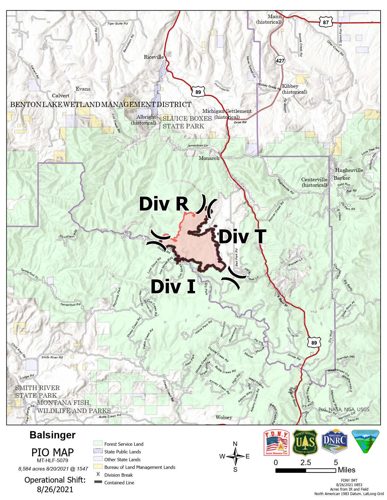
Balsinger Fire
Location: 5 miles W of Neihart, MT | Acreage: 8,584 | Containment: 77% | Start date: July 9, 2021 Personnel: 57
Firefighters and engines continue to patrol and mop-up along containment lines. There are no notable hot spots at this time and smoldering among the heavier fuels within the fire perimeter is likely. Today, Crews will continue mop up and patrol in Divisions I and T. Division R remains unstaffed. Steep, inaccessible terrain and heavy fuels in Division R make direct attack along the north edge unsafe for firefighters. There is very little heat and no fire growth in that division. Fire officials have identified Management Action Points. In the unlikely event the fire reaches these points, alternative tactics will be implemented.
Woods Creek Fire
Location: 16 miles NE of Townsend, MT | Acreage: 55,411 | Containment: 61% | Start date: July 10, 2021 | Personnel: 387
Creeping and backing on the fire may occur today, and smokes are likely to show in the interior of the fire. The potential for spotting remains low. Crews are continuing to patrol the fire perimeter in Divisions Y and A. In Division A, suppression repair continues today. The eastern edge of the fire, in Divisions A and O, is in patrol and mop-up status, except for a small “finger” near Big Birch Creek. Control line is in place, and crews continue to work towards containment in this area of the fire. At the southeast edge, a hotshot crew is working near Russell Fork Deep Creek to contain a hot spot burning in snags and timber. Crews in both Division Q and Division S are working to complete chipping and mastication on the contingency line in those divisions. In Division S, crews are patrolling, mopping up, and strengthening contingency lines and continue to monitor hot spots in the North Fork of Duck Creek. Interior smokes are visible in this division, but there is minimal heat near the fire perimeter. Interior fuels may continue to burn until there is a season-ending event.
American Fork Fire
The American Fork fire is under the command of the Albuquerque Zone Type 3 Incident Management Team.
Weather and Fuel Conditions: Cloudy, breezy and cooler conditions are expected today, as an unsettled weather pattern continues. There is the chance for showers and thunderstorms to develop by early afternoon and continue until 8:00pm. More widespread showers and thunderstorm activity is expected Friday.
Evacuation Notices
For questions or more information on evacuations, please contact your local county sheriff’s office.
American Fork Fire: The Park County Sheriff’s Office has Shields River Road in pre-evacuation status. Meagher County has done the same with the Smith Creek area.
Balsinger Fire: The Cascade County Sheriff’s Office has issued pre-evacuation orders for Belt Park, the area from the Belt Creek Ranger Station to Monarch, and from west of Monarch to the confluence of Pilgrim Creek and Belt Creek.
Woods Creek Fire: The Broadwater County Sheriff’s Office has lifted all evacuation and pre-evacuation orders and warnings for all areas of the Woods Creek Fire on the Broadwater County side. The Meagher County Sheriff’s Office has lifted the pre-evacuation for the area east of Camas Creek Road and north of North Fork Woods Gulch Creek to Luppold Road. On the east side of the fire, the area south of Burt Ranch Road and west of Camas Creek Road is in pre-evacuation status. A pre-evacuation notice remains for residents on Birky Road and Ramspeck Lane and for Grassy Mountain residents.
Closures and Advisories
Most of the Helena-Lewis and Clark National Forest is in Stage 2 fire restrictions. For details see: https://go.usa.gov/xFMGd.There are closure areas for the Balsinger Fire (https://go.usa.gov/xFMGk) Woods Creek Fire (https://go.usa.gov/xFMG5) and American Fork Fire (https://go.usa.gov/xFMGy).
Stage 1 fire restrictions remain in place for the Custer Gallatin National Forest. For more information, see the first item in the Alerts section at https://www.fs.usda.gov/alerts/custergallatin/alerts-notices. There is an updated closure area for the American Fork Fire as of August 24th. See: https://go.usa.gov/xFMGf.
The Bureau of Land Management Butte and Lewiston Field Offices issued an area closure for lands affected by the Woods Creek Fire. See: https://go.usa.gov/xFMGG.
Daily Update 08272021
Related Incident:
Publication Type: News
Balsinger, Woods Creek, and
American Fork Fires Update
Friday August 27, 2021 – 10:00 am
Fire Department City of New York Type 2 Incident Management Team
Richard DePrima, Incident Commander – Balsinger and Woods Creek Fires
Albuquerque Zone Type 3 Incident Management Team
Zach Saavedra, Incident Commander – American Fork Fire
Information phone: 406-426-9612
Email: 2021.divide@firenet.gov
Information staffing hours: 8:00 am – 8:00 pm
Special Notes: If you missed last night’s virtual meeting, it can be found at Facebook Live Community Meeting.
Forest Service Order Number 01-15-07-21-32 issued on August 26th, is in effect for the Balsinger Fire area of the Divide Complex Fire. For details see Order 01-15-07-21-32.
Effective today, Fire Updates will be released on Monday, Wednesday and Friday only. Daily Updates will no longer be issued.
Current Situation: Work continues today on strengthening containment and contingency lines and mopping up hot spots. Cooperating agencies have approved suppression repair plans and crews will repair hand line and dozer line to mitigate impacts to natural and cultural resources. Control lines that are still needed to prevent fire spread will remain in place until fire season has ended. Other repair activities include pulling back berms and installing water bars to prevent soil erosion and water run-off.
Balsinger Fire
Location: 5 miles W of Neihart, MT | Acreage: 8,584 | Containment: 77% | Start date: July 9, 2021 Personnel: 51
Firefighters and engines continue to patrol and mop-up along containment lines. Equipment is being back-hauled, including hose lays and pumps. Fire suppression repair will also begin today. Smoldering among the heavier fuels within the fire perimeter is possible. Crews will continue mop up and patrol in Divisions I and T. Division R remains unstaffed. Steep, inaccessible terrain and heavy fuels in Division R make direct attack along the north edge unsafe for firefighters. There has been no fire growth. Fire officials have identified Management Action Points. In the unlikely event the fire reaches these points, alternative tactics will be implemented.
Woods Creek Fire
Location: 16 miles NE of Townsend, MT | Acreage: 55,411 | Containment: 61% | Start date: July 10, 2021 | Personnel: 433
Minimal fire activity is expected again today. Smoldering and creeping may occur. Crews are continuing to patrol the fire perimeter in Divisions Y and A. Suppression repair continues again today those divisions. Divisions O remains in a patrol and mop-up status, with little activity on the small “finger” near Big Birch Creek. Control line is in place, and crews continue to work towards containment in this area of the fire. At the southeast edge, a hotshot crew is working near Russell Fork Deep Creek to contain a hot spot. Crews in both Division Q and Division S are working to complete chipping and mastication on the contingency line in those divisions. Division Q and Division S are preparing for suppression repair in those divisions. In Division S, crews are also in patrol and mop-up status. They continue to monitor for hot spots in the North Fork of Duck Creek. Interior smokes may be visible in this division, but there is minimal heat near the fire perimeter. Interior fuels may continue to burn until there is a season-ending event.
American Fork Fire
Location: 24 miles SW of Harlowtown, MT | Acreage: 21,892 | Containment: 68% | Start date: July 17, 2021 | Personnel: 180
The American Fork fire is under the command of the Albuquerque Zone Type 3 Incident Management Team.
Over the next twenty-four to seventy-two hours significant changes can be expected on the American Fork Fire. The spike camp located at Melville was dismantled with all resources and supplies transferred to the Shields Valley Ranch (SVR) spike. The SVR spike is scheduled for demobilization and removal on Saturday August 28. The Albuquerque IMT last working day is Sunday, August 29th at which time the incident will be turned over the local unit.
On August 24 the scheduled Infrared (IR) flight detected no significant heat, and the August 26 flight identified minimal heat north of Lebo Peak. Resources on Division F did find a few isolated heat sources too small to be identified by the IR, although these were of no concern and were not impacting the line. Crews continue to do repair work on Division F as well as reinforce line near the Lodgepole Trailhead.
The Montana National Guard crews removed the protective wrap on the Porcupine Cabin on Division A in addition to assisting with the inventory and preparation of supplies for return to the fire cache to be distributed to other fires. Division K was assessed by the Division Chief and their trainee for possible means of increasing containment on the Northeast portion of the line. In Division Z, crews focused on repairs so that local landowners could use pastureland.
Weather and Fuel Conditions: A strong disturbance and cold front will cross the region today and bring widespread shower and thunderstorm activity throughout the daytime period. Chilly temperatures are expected late Friday night and Saturday morning.
Evacuation Notices
For questions or more information on evacuations, please contact your local county sheriff’s office.
American Fork Fire: The Park County Sheriff’s Office has Shields River Road in pre-evacuation status. Meagher County has done the same with the Smith Creek area.
Balsinger Fire: The Cascade County Sheriff’s Office has issued pre-evacuation orders for Belt Park, the area from the Belt Creek Ranger Station to Monarch, and from west of Monarch to the confluence of Pilgrim Creek and Belt Creek.
Woods Creek Fire: The Broadwater County Sheriff’s Office has lifted all evacuation and pre-evacuation orders and warnings for all areas of the Woods Creek Fire on the Broadwater County side. The Meagher County Sheriff’s Office has lifted the pre-evacuation for the area east of Camas Creek Road and north of North Fork Woods Gulch Creek to Luppold Road. On the east side of the fire, the area south of Burt Ranch Road and west of Camas Creek Road is in pre-evacuation status. A pre-evacuation notice remains for residents on Birky Road and Ramspeck Lane and for Grassy Mountain residents.
Closures and Advisories
Areas around the fires are closed for public safety. Please respect the closure signs. Traffic on closed roads creates safety hazards for firefighters and emergency vehicles.
Temporary flight restrictions remain in place over the American Fork Fire area. Wildfires are a no-fly zone for unauthorized aircraft, including drones. If you fly, we can’t. http://knowbeforeyoufly.org.
Most of the Helena-Lewis and Clark National Forest is in Stage 2 fire restrictions. For details see: https://go.usa.gov/xFMGd.There are closure areas for the Balsinger Fire (https://go.usa.gov/xFMGk) Woods Creek Fire (https://go.usa.gov/xFMG5) and American Fork Fire (https://go.usa.gov/xFMGy).
Stage 1 fire restrictions remain in place for the Custer Gallatin National Forest. For more information, see the first item in the Alerts section at https://www.fs.usda.gov/alerts/custergallatin/alerts-notices. There is an updated closure area for the American Fork Fire as of August 24th. See: https://go.usa.gov/xFMGf.
The Bureau of Land Management Butte and Lewiston Field Offices issued an area closure for lands affected by the Woods Creek Fire. See: https://go.usa.gov/xFMGG.
Stage 1 Fire Restrictions For Helena Lewis and Clark National Forest
Related Incident:
Publication Type: Closures
Order Number 01-15-00-21-33
UNITED STATES DEPARTMENT OF AGRICULTURE
FOREST SERVICE
HELENA-LEWIS & CLARK NATIONAL FOREST
HELENA, MONTANA
FOREST ORDER
STAGE 1 FIRE RESTRICTIONS
Pursuant to 16 USC 551 and Title 36 CFR 261.50 (a), the following acts are prohibited within all National Forest System lands as described in this Order (the “Restricted Area”) on the Helena-Lewis & Clark National Forest:
PROHIBITIONS:
3. Welding or operating acetylene or other torch with open flame. [36 CFR 261.52(i)]
RESTRICTED AREA
All National Forest System lands, roads, and trails within the exterior boundaries of the Helena-Lewis & Clark National Forest as depicted on Attachments A, C, D, E, F, G and H.
PURPOSE:
To reduce fire risk, prevent human-caused wildland fires, protect property, and protect public health and safety during periods of high or extreme fire danger.
IMPLEMENTATION:
This order will be in effect from 00:01AM Saturday, August 28, 2021 and shall remain in effect until 00:01 AM Saturday, October 2, 2021 or until the order is rescinded, whichever occurs first.
These prohibitions are in addition to the general prohibitions in 36 CFR Part 261, Subpart A.
This Order supersedes any previous orders, including Order Numbers 01-15-00-21-16, 01-15-00-21-21, 01-15-14-21-24 and 01-15-00-21-29, prohibiting the same acts covered by this order.
EXEMPTIONS:
Pursuant to 36 CFR 261.50 (e), the following persons are exempt from this order:
Persons with a special use authorization or other Forest Service authorization specifically
exempting them from the effect of this Order. 36 CFR § 261.50(e)(1).
Any Federal, State, or local officer, or member of an organized rescue or fire fighting force in the performance of an official duty. 36 CFR § 261.50(e)(4).
For Prohibition #1, building, maintaining, attending or using a fire in constructed, permanent fire rings within identified developed recreation sites (Attachment A2) and the use of portable stoves, terns using gas, jellied petroleum, pressurized liquid fuel or a fully enclosed (sheepherder type) stove with a ¼” spark arrester type screen is permitted. 36 CFR § 261.50(e)(6).
For Prohibition #1, petroleum-fueled stoves, gas lanterns, pressurized liquid fuel and fully enclosed stoves may only be used in areas that are barren or cleared of all overhead and surrounding flammable materials within 3 feet of the device. 36 CFR § 261.50(e)(6).
For Prohibition #3, welding or operating acetylene or other torch with open flame is permitted in a cleared area of at least 10 feet in diameter and in possession of a chemical pressurized fire extinguisher. 36 CFR § 261.50(e)(6).
VIOLATION:
Violation of these prohibitions is punishable by a fine of not more than $5,000 for an individual or $10,000 for an organization, imprisonment for not more than 6 months, or both. (16 U.S.C.
§551 and 18 U.S.C. §§ 3559, 3571 and 3581(b)(7)).
INFORMATION:
Further information regarding this order may be obtained at the Helena-Lewis & Clark Forest Supervisor’s Office located at 2880 Skyway Drive, Helena, Montana, 59602, (406) 449-5201.
Executed in Helena, Montana, this 27th day of August, 2021. Sara Mayben
Acting Forest Supervisor
ATTACHMENT A2-DEVELOPED RECREATION AREAS
Belt Creek- White Sulphur Springs Ranger District:
• Aspen Campground
• Kings Hill Campground
• Many Pines Campground
• Logging Creek Campground
• Jumping Creek Campground
• Moose Creek Campground
• Grasshopper Campground
Judith-Musselshell Ranger District:
• Dry Wolf Campground
• Crystal Lake Campground
• Hay Canyon Campground
• Thain Creek Campground
• Spring Creek Campground
Rocky Mountain Ranger District:
• Benchmark Campground
• Cave Mountain Campground
• Double Falls Campground
• Elko Campground
• Home Gulch Campground
• Mill Falls Campground
• Mortimer Gulch Campground
• South Fork Sun Campground
• Summit Campground
• Beaver Creek Dispersed Campsite
• Van Deriet Campground
• West Fork Campground
• Wood Lake Campground
• Wood Lake Picnic Area
• West Fork Cabin
• Ford Creek Ranch
• Kenck Cabin
• Benchmark Wilderness Ranch
• Sun Canyon Lodge
• 7 Lazy P Guest Ranch
Townsend Ranger District:
• Gipsy Lake Campground (* currently in fire closure area)
• Skidway Campground
• Bar Gulch Cabin
• Eagle Guard Cabin
• Deep Creek Picnic Area
• Rillway Cabin
• Thompson Guard Station (* currently in fire closure area)
• Miller Cabin (* currently in fire closure area)
• Gipsy Day Use (* currently in fire closure area)
Lincoln Ranger District:
• Aspen Grove Campground
• Alice Creek Trailhead/ Day Use Area
• Pine Grove Campground
• Blackfoot Canyon Campground
• Copper Creek Campground
• Granite Butte Lookout
• Indian Meadows Guard Station
• Cummings Cabin
• Nevada Creek Cabin
Helena Ranger District:
• Coulter Campground
• Kading Campground
• Moose Creek Campground
• Park Lake Campground
• Vigilante Campground
• Cromwell-Dixon Campground
• Indian Flats Cabin
• Strawberry Lookout Cabin
• Kading Cabin
• Moose Creek Cabin
• Meriwether Picnic Area
• Park Lake Day Use Area
• Ten Mile Picnic Area
Balsinger Fire Update 08302021
Related Incident:
Publication Type: News
Balsinger, Woods Creek, and American Fork Fires Update
Monday August 27, 2021 – 10:00 am
Fire Department City of New York Type 2 Incident Management Team
Richard DePrima, Incident Commander – Balsinger and Woods Creek Fires
Custer Gallatin National Forest
Wes Woodrome, Incident Commander – American Fork Fire
Information phone: 406-426-9612
Email: 2021.divide@firenet.gov
Information staffing hours: 8:00 am – 8:00 pm
Special Notes: Fire Updates will continue to be released on Monday, Wednesday and Friday only. Transfer of management of the American Fork Fire, from Albuquerque Zone IMT Type 3 back to the Custer Gallatin National Forest, occurred Sunday August 29th.
Current Situation: Work continues today on strengthening containment and contingency lines and mopping up hot spots. Cooperating agencies have approved suppression repair plans and crews will repair hand line and dozer line to mitigate impacts to natural and cultural resources. Control lines that are still needed to prevent fire spread will remain in place until fire season has ended. Other repair activities include pulling back berms and installing water bars to prevent soil erosion and water run-off.
Balsinger Fire
Location: 5 miles W of Neihart, MT | Acreage: 8,584 | Containment: 77% | Start date: July 9, 2021 Personnel: 51
Firefighters and engines continue to patrol and mop-up along containment lines. Equipment is being back-hauled, including hose lays and pumps. Fire suppression repair will also begin today. Smoldering among the heavier fuels within the fire perimeter is possible. Crews will continue mop up and patrol in Divisions I and T. Division R remains unstaffed. Steep, inaccessible terrain and heavy fuels in Division R make direct attack along the north edge unsafe for firefighters. There has been no fire growth. Fire officials have identified Management Action Points. In the unlikely event the fire reaches these points, alternative tactics will be implemented.
Woods Creek Fire
Location: 16 miles NE of Townsend, MT | Acreage: 55,411 | Containment: 61% | Start date: July 10, 2021 | Personnel: 433
Minimal fire activity is expected again today. Smoldering and creeping may occur. Crews are continuing to patrol the fire perimeter in Divisions Y and A. Suppression repair continues again today those divisions. Divisions O remains in a patrol and mop-up status, with little activity on the small “finger” near Big Birch Creek. Control line is in place, and crews continue to work towards containment in this area of the fire. At the southeast edge, a hotshot crew is working near Russell Fork Deep Creek to contain a hot spot. Crews in both Division Q and Division S are working to complete chipping and mastication on the contingency line in those divisions. Division Q and Division S are preparing for suppression repair in those divisions. In Division S, crews are also in patrol and mop-up status. They continue to monitor for hot spots in the North Fork of Duck Creek. Interior smokes may be visible in this division, but there is minimal heat near the fire perimeter. Interior fuels may continue to burn until there is a season-ending event.
American Fork Fire
Location: 24 miles SW of Harlowtown, MT | Acreage: 21,892 | Containment: 68% | Start date: July 17, 2021 | Personnel: 180
The American Fork fire is under the command of the Albuquerque Zone Type 3 Incident Management Team.
Over the next twenty-four to seventy-two hours significant changes can be expected on the American Fork Fire. The spike camp located at Melville was dismantled with all resources and supplies transferred to the Shields Valley Ranch (SVR) spike. The SVR spike is scheduled for demobilization and removal on Saturday August 28. The Albuquerque IMT last working day is Sunday, August 29th at which time the incident will be turned over the local unit.
On August 24 the scheduled Infrared (IR) flight detected no significant heat, and the August 26 flight identified minimal heat north of Lebo Peak. Resources on Division F did find a few isolated heat sources too small to be identified by the IR, although these were of no concern and were not impacting the line. Crews continue to do repair work on Division F as well as reinforce line near the Lodgepole Trailhead.
The Montana National Guard crews removed the protective wrap on the Porcupine Cabin on Division A in addition to assisting with the inventory and preparation of supplies for return to the fire cache to be distributed to other fires. Division K was assessed by the Division Chief and their trainee for possible means of increasing containment on the Northeast portion of the line. In Division Z, crews focused on repairs so that local landowners could use pastureland.
Weather and Fuel Conditions: A strong disturbance and cold front will cross the region today and bring widespread shower and thunderstorm activity throughout the daytime period. Chilly temperatures are expected late Friday night and Saturday morning.
Evacuation Notices
For questions or more information on evacuations, please contact your local county sheriff’s office.
American Fork Fire: The Park County Sheriff’s Office has Shields River Road in pre-evacuation status. Meagher County has done the same with the Smith Creek area.
Balsinger Fire: The Cascade County Sheriff’s Office has issued pre-evacuation orders for Belt Park, the area from the Belt Creek Ranger Station to Monarch, and from west of Monarch to the confluence of Pilgrim Creek and Belt Creek.
Woods Creek Fire: The Broadwater County Sheriff’s Office has lifted all evacuation and pre-evacuation orders and warnings for all areas of the Woods Creek Fire on the Broadwater County side. The Meagher County Sheriff’s Office has lifted the pre-evacuation for the area east of Camas Creek Road and north of North Fork Woods Gulch Creek to Luppold Road. On the east side of the fire, the area south of Burt Ranch Road and west of Camas Creek Road is in pre-evacuation status. A pre-evacuation notice remains for residents on Birky Road and Ramspeck Lane and for Grassy Mountain residents.
Closures and Advisories
Areas around the fires are closed for public safety. Please respect the closure signs. Traffic on closed roads creates safety hazards for firefighters and emergency vehicles.
Temporary flight restrictions remain in place over the American Fork Fire area. Wildfires are a no-fly zone for unauthorized aircraft, including drones. If you fly, we can’t. http://knowbeforeyoufly.org.
The Helena-Lewis and Clark National Forest is back to Stage 1 fire restrictions. For details see: Helena-Lewis and Clark Stage 1 fire restrictions. There are closure areas for the Balsinger Fire (Balsinger Fire Closures Woods Creek Fire (Woods Creek Fire Closures) and American Fork Fire (American Fork Fire Closures).
Stage 1 fire restrictions remain in place for the Custer Gallatin National Forest. For more information, see the first item in the Alerts section Custer Gallatin Restrictions.
The Bureau of Land Management Butte and Lewiston Field Offices issued an area closure for lands affected by the Woods Creek Fire. See: BLM Woods Creek Fire Closures
For more information:
Information phone: 406-426-9612
Facebook: https://bit.ly/2XiK1Et
Email: 2021.divide@firenet.gov
American Fork InciWeb: inciweb.nwcg.gov/incident/7681
Balsinger InciWeb: inciweb.nwcg.gov/incident/7624
Woods Creek InciWeb: inciweb.nwcg.gov/incident/7649
Smoke information: https://fire.airnow.gov/# or https://svc.mt.gov/deq/todaysair/smokemostrecentupdate.aspx
Statewide fire restrictions: www.MTFireInfo.org
Fire Update 09012021
Related Incident:
Publication Type: News
Balsinger, Woods Creek, and American Fork Fires Update
Wednesday, September 1, 2021 – 10:00 am
Fire Department City of New York Type 2 Incident Management Team
Richard DePrima, Incident Commander – Balsinger and Woods Creek Fires
Custer Gallatin National Forest Type 4
Wes Woodrome, Incident Commander – American Fork Fire
Special Notes: This will be the last Fire Update in this format. Due to minimal fire activity, InciWeb will be updated Monday, Wednesday, and Friday by the US Forest Service, unless significant changes occur. Please refer directly to the Helena-Lewis & Clark and Custer Gallatin National Forests home and Facebook pages for additional fire information.
Helena Lewis and Clark National Forest home page: https://www.fs.usda.gov/hlcnf/
Helena Lewis and Clark National Forest Facebook page: https://www.facebook.com/HLCNF
Custer Gallatin National Forest home page: https://www.fs.usda.gov/main/custergallatin/home
Custer Gallatin National Forest Facebook page: https://www.facebook.com/CusterGallatinNationalForest
At 6:00am, on Thursday September 2nd 2021, the transition of command of the Woods Creek and Balsinger Fires will occur. The Woods Creek Fire will be commanded by the Martinez Type 3 IMT. The Balsinger Fire will be turned back over to the US Forest Service. The FDNY Type 2 IMT greatly appreciate the overwhelming welcome, support, and cooperation from our Agency Administrators, co-operators, and the community during our deployment.
Current Situation: Work continues today to strengthen containment and contingency lines and mop-up hot spots. Cooperating agencies have approved suppression repair plans, and crews continue to repair hand and dozer lines to mitigate impacts to natural and cultural resources. Control lines still needed to prevent fire spread will remain in place until fire season has ended. Other repair activities include pulling back berms and installing water bars to prevent soil erosion and water run-off.
Balsinger Fire
Location: 5 miles W of Neihart, MT | Acreage: 8,584 | Containment: 77% | Start date: July 9, 2021 Personnel: 57
There has been no fire growth. Firefighters and engines continue to patrol and mop up along containment lines. Smoldering among the heavier fuels within the fire perimeter is possible. Crews will continue patrol, mop-up, and suppression repair in Divisions I and T. Division R remains unstaffed. Steep, inaccessible terrain and heavy fuels in Division R make direct attack along the north edge unsafe for firefighters. Equipment is being back-hauled, including hose lays and pumps.
Woods Creek Fire
Location: 16 miles NE of Townsend, MT | Acreage: 55,411 | Containment: 90% | Start date: July 10, 2021 | Personnel: 342
Minimal fire activity is expected again today. Crews continue to monitor and patrol for hot spots along the perimeter and work to improve contingency lines. Crews in Division Q and Division S completed chipping and mastication along contingency lines. Suppression repair continues in Divisions O, A, and Y. Interior smokes may be visible, but minimal heat near the fire perimeter. Interior fuels may continue to burn until there is a season-ending event.
American Fork Fire
Location: 24 miles SW of Harlowtown, MT | Acreage: 21,892 | Containment: 75% | Start date: July 17, 2021 | Personnel: 60
Repair efforts continue on the American Fork fire. Crews are removing snags from the campgrounds and roads to make the area safe for the public. There are the occasional hold ups as strong winds can hamper tree felling activity. The Shields Loop is being graded. Preparations are being made for re-seeding the areas effected by suppression. Seed and equipment have been ordered and is en-route. The Baer Team, led by Dale White, will arrive today. This incident will continue “right-sizing” as necessary to maintain financial responsibility while keeping production. Today, the Martinsdale information board will be dismantled.
Weather and Fuel Conditions: Temperatures return to slightly below normal for early September starting today, with chances for showers and thunderstorms Thursday night and Friday as a weak disturbance moves through the area. Warmer and drier conditions build in over the coming weekend. If no precipitation is received, we will continue to see smoldering, creeping and an isolated tree torching.
Evacuation Notices: For more information or questions on evacuations, please contact your local county sheriff’s office.
American Fork Fire: No evacuations are active. All pre-evacuation notices have been rescinded.
Balsinger Fire: The Cascade County Sheriff’s Office has rescinded all pre-evacuation orders for Belt Park, the area from the Belt Creek Ranger Station to Monarch, and from west of Monarch to the confluence of Pilgrim Creek and Belt Creek.
Woods Creek Fire: The Broadwater County Sheriff’s Office has lifted all evacuation and pre-evacuation orders and warnings for all areas of the Woods Creek Fire on the Broadwater County side. The Meagher County Sheriff’s Office has lifted the pre-evacuation for the area east of Camas Creek Road and north of North Fork Woods Gulch Creek to Luppold Road. On the east side of the fire, the area south of Burt Ranch Road and west of Camas Creek Road is in pre-evacuation status. A pre-evacuation notice remains for residents on Birky Road and Ramspeck Lane and for Grassy Mountain residents.
Closures, Advisories, Restrictions
Areas around the fires are closed for public safety. Please respect the closure signs. Traffic on closed roads creates safety hazards for firefighters and emergency vehicles.
Temporary flight restrictions remain in place over the American Fork Fire area. Wildfires are a no-fly zone for unauthorized aircraft, including drones. If you fly, we can’t. http://knowbeforeyoufly.org.
Closure areas:
Balsinger Fire: https://go.usa.gov/xFhHP
Woods Creek Fire: https://go.usa.gov/xFhHy
American Fork Fire: (Custer Gallatin NF) https://go.usa.gov/xFhH9 (Helena-Lewis and Clark NF) https://go.usa.gov/xFhHd
Bureau of Land Management Butte and Lewiston Field Offices: Woods Creek Fire closures https://go.usa.gov/xFMGG
Fire restrictions:
Helena - Lewis and Clark National Forest is in Stage 1 fire restrictions. For details see: https://go.usa.gov/xFhyt
Custer Gallatin National Forest is in Stage 1 fire restrictions. For details, see: Item one in the Alerts and Notices page and select section: https://www.fs.usda.gov/alerts/custergallatin/alerts-notices
For Additional Information:
American Fork Fire Forrest Ford PIO 406-223-5630 (8am - 4:30pm)
Balsinger Fire White Sulphur Springs Ranger Station 406-547-3361 (8am - 4:30pm)
Woods Creek Fire Townsend Ranger Station 406-266-3425 (8am - 4:30pm)
American Fork Fire InciWeb: inciweb.nwcg.gov/incident/7681
Balsinger Fire InciWeb: inciweb.nwcg.gov/incident/7624
Woods Creek Fire InciWeb: inciweb.nwcg.gov/incident/7649
Smoke information: https://fire.airnow.gov/# or https://svc.mt.gov/deq/todaysair/smokemostrecentupdate.aspx
Statewide fire restrictions: www.MTFireInfo.org
All closures rescinded for Balsinger Fire hazards remain
Related Incident:
Publication Type: Closures
As of 9/15/21 there are no closures in place for the Balsinger Fire. Hazards remain!! Use extreme caution if traveling in an area that has recently seen fire.