
Incident Publication
Daily Fire Update American Fork Divide Complex and Woods Creek 8102021
Related Incident:
Publication Type: News
Divide Complex Daily Update
Tuesday, August 10, 2021
American Fork, Balsinger, Ellis and Woods Creek fires
Phone: 406-426-9612 (8 a.m. – 8 p.m.)
Facebook: www.facebook.com/HLCNF
Twitter: https://twitter.com/LewisandClarkNF
Email: 2021.divide@firenet.gov
On Sunday the Meagher County Sheriff’s Office issued an Evacuation Notice for Grassy Mountain residents north of Highway 12.
Monday, the Meagher County Sheriff’s Department changed the Smith Creek evacuation notice to pre-evacuation.
Please note: A virtual community meeting about all fires will be tonight at 7 p.m. Join ZoomGov Meeting
https://usfs.zoomgov.com/j/1600787603 Meeting ID: 160 078 7603
or watch on Facebook Live at: www.facebook.com/HLCNF or www.facebook.com/CGNF.
While the recent rain reduced fire activity and allowed firefighters to go directly to the fire’s edge to fight the fires in some areas, it also made unsurfaced roads wet and susceptible to damage from firefighting vehicles. To protect these roads, firefighters stayed off the roads in some areas or waited for them to dry before accessing them. Although fire behavior was minimal yesterday, heat still remains and flames will pop up as the vegetation dries. As fire behavior analyst Greg Titus said, “This fire may seem calm, but all fires start with a smoke. This fire is not done.”
American Fork Fire inciweb.nwcg.gov/incident/7681
Acreage: 19,028 Containment: 10% Start date: July 17, 2021 Cause: Lightning Personnel: 82
The American Fork Fire is burning in the central part of the Crazy Mountains, about 24 miles southwest of Harlowton, Montana. It’s burning on both the east and west side of the mountain range, approximately 12 miles northeast from Wilsall and approximately six miles west from Melville.
The fire area received between 0.3 – 0.6 inch of rainfall Sunday, so fire behavior was minimal yesterday. This morning the RH was 40%, with winds clocking up to 40 mph. Pockets of heat remain near Shields River, Lodgepole Creek and Loco Mountain. Firefighters will assess where it grew in that area and look for places to construct line. This morning, firefighters will monitor and build fireline directly at the fire’s edge. Providing structure protection in the Shields River area remains a primary focus. Firefighters will mop up and tie in line around Loop Road and Crandall Creek. Crews are putting in direct line where possible around the area near Buck Creek, where a finger of fire grew Saturday. Crews will use a chipper to remove burnable vegetation along Shields River and Bennet Creek roads to create fire breaks and construct fireline.
Balsinger and Ellis fires inciweb.nwcg.gov/incident/7624 inciweb.nwcg.gov/incident/7625
Acreage: Balsinger 8,614 Ellis 1,220 Containment: 45% Start date: July 8, 2021 Cause: Balsinger -Lightning; Ellis – under investigation. Personnel: 301
The Balsinger Fire is burning about five miles west of Neihart, Montana. Out of all fires, the Balsinger Fire received the most rain Sunday, with 1.4 inches measured at one rain gauge. Fire behavior was minimal. Diminished fire behavior is expected today on all areas of the fire due to the rainfall. Areas of heat, such as those south of Thunder Mountain, may show back up today as fuels dry. Crews will be in monitor and patrol status today, going direct where safe to do so. Divide Road toward Deer Creek is also still showing heat. Firefighters continue to protect the communities of Neihart and Monarch, both about four miles from the fire’s edge. The focus for today remains point/structure protection, making sure livestock has been removed to safe areas, reassessing the fire perimeter to establish anchor points and improving established anchor points.
The Ellis Fire, about 2.5 miles southwest of Smith River, Montana, is in patrol status with daily monitoring by aircraft. No smoke has been observed from this fire in the past few days. Heavy and live fuels are still at critical levels and will continue to smolder until the fuels are fully consumed or a significant amount of rain falls.
Woods Creek Fire inciweb.nwcg.gov/incident/7649
Acreage: 45,590 Containment: 3% Start date: July 10, 2021 Cause: Lightning Personnel: 405
The Woods Creek Fire continues to burn in the Big Belt Mountains, about 16 miles northeast of Townsend, Montana, and has moved onto private lands. Fire behavior was minimal with creeping and smoldering in heavy fuels that were sheltered from the rain. Most of the fire area received up to ½ inch from the storms that moved through. Today, crews are constructing more line on the eastern edge and scouting for line locations on the northern end. Dozers have been pushing in line to the northeast, while firefighters continue assessing line to the north and northeast. Crews are going direct and mopping up around Confederate Gulch. Crews will be monitoring and improving constructed lines on private lands in cooperation with local landowners. Firefighters will use a combination of equipment and hand crews to reduce fire spread to the East along Big Birch drainage and surrounding private lands.
Firefighters have been working on handline construction and structure protection and will continue assessing options for line construction north to Elk Creek and south to Butte Creek, connecting line from Boulder Creek to North Fork Duck Creek and south to Duck Creek Road. Crews are constructing line to New River Road. Mop up and patrol the area around Thompson Guard Station will continue. One outbuilding has been reported lost on the fire.
Evacuation Notices
American Fork Fire
A pre-evacuation order remains in place for residences in the Shields River Road area.
A mandatory evacuation is still in effect for the Smith Creek area and portions of the Upper Shields River.
A pre-evacuation order for Smith Creek subdivision was issued by the Meagher County Sheriff’s Office.
Balsinger Fire
An evacuation order for Belt Park, issued by the Cascade County Sheriff’s Office, remains in place.
A pre-evacuation order was issued for the area from the Belt Creek Ranger Station to Monarch and from west of Monarch to the confluence of Pilgrim Creek and Belt Creek.
The Broadwater County Sheriff’s Office has issued an evacuation order in connection with the Woods Creek Fire.
A mandatory evacuation order issued by the Broadwater County Sheriff’s Office remains in place for the Woods Creek Fire, covering everything east of Highway 284 between Gravely Lane on the north and Dry Gulch Road on the south. Ray Creek is on high alert. Highway 284 remains open.
A mandatory evacuation of six cabins and Big Birch Creek is in place.
The Meagher County Sheriff’s Office issued a Pre-Evacuation Notice for residents on Birky Road and Ramspeck Lane around 5 p.m. Saturday, 8/7.
The Meagher County Sheriff’s Office issued a Pre-Evacuation Notice for Grassy Mountain residents north of Highway 12.
NEW: We received official word Monday night from Meagher County Sheriff’s Department that the Smith Creek evacuation notice has been changed to pre-evac effective immediately.
Weather
All fires in our area received over ½ inch rain and strong winds Sunday, from 30-50 mph. Woods Creek experienced severe thunderstorms, while Balsinger received wetting rain between ¾ to 1 ¼ inches. Temperatures rebound today and relative humidity levels decrease. As the inversion breaks, west winds will pick up 10-20 mph, with gusts up to 40 mph. There will be a slight chance of thunderstorms over higher terrain in the late afternoons at the end of the week. Above normal temperatures are expected from Wednesday through the weekend with afternoon relative humidity values dropping below 20 percent. Diminished fire behavior today is expected on all divisions due to recent rainfall, but areas of heat will show back up as fuels dry. Firefighters will watch for smoldering heat.
Closures
Temporary flight restrictions (TFR) remain in place for the American Fork Fire , the Balsinger Fire and the Woods Creek Fire. New: the TFR on the east side of the Woods Creek Fire has been expanded.
The Belt Creek-White Sulphur Springs Ranger District, Helena-Lewis and Clark National Forest expanded the closure area for the Balsinger Fire on July 29.
The closure order for the part of the American Fork fire on the Custer-Gallatin National Forests was updated on July 29 (map).
The Big Elk Creek Trail (#640) on the part of the American Fork fire on the Helena-Lewis and Clark National Forest remains in place. This also includes the Big Elk Creek Trailhead.
The Helena-Lewis and Clark National Forest issued an area closure for the Woods Creek Fire on July 26, 2021. An additional closure was issued for the Woods Creek Fire August 4, 2021.
Advisories
Help prevent additional fire starts by following all campfire restrictions and fire-related closures.
Most of the Helena-Lewis and Clark National Forest is in stage 2 fire restrictions.
Stage 1 fire restrictions remain in place for the Custer Gallatin National Forest. The Custer Gallatin has also restricted campfires in all locations.
Visit www.MTFireInfo.org for statewide fire restriction information.
Visit the AirNow.gov website for more information on air quality near you.
PreEvacuation notice from Park Co Sheriffs Office for American Fork Fire
Related Incident:
Publication Type: Announcement
NEW: As of August 9, Park Co Sheriff’s Office has moved Shields River Road residents back to pre-evacuation status. Meager County has done the same with the Smith Creek area.
This is due to favorable weather and fire behavior but could change as needed.
The county roads in the area are open; however, there are still closures in the forest.
Daily Update American Fork Balsinger and Woods Creek Fires 20210812
Related Incident:
Publication Type: News
American Fork, Balsinger, and Woods Creek Fires Update
Thursday, August 12, 2021-9 a.m.
Rocky Mountain Type 1 Incident Management Team
Dan Dallas, Incident Commander
Phone: 406-426-9612 (8 a.m. – 8 p.m.)
Facebook: @WoodsCreekBalsingerAmericanForkFires
Email: 2021.divide@firenet.gov
Management of the Ellis Fire has been transferred back to the Helena-Lewis and Clark NF and will no longer be reported here.
The Rocky Mountain Type 1 Incident Management Team assumed command over these fires today at 7 a.m.
Information on the Woods Creek, Balsinger and American Fork fires will be posted on a new Facebook site. @WoodsCreekBalsingerAmericanForkFires
There is now an interactive web map available for your use. You can use this map to determine distance and location of the fires from your address. See this link: https://bit.ly/WoodsCreekBalsingerAmericanForkFires
Current Situation: Winds are weakening today, with the weather becoming dry and hot over the weekend. Today will see an uptick in the number and amount of smokes popping up. We are beginning to see the drying effects of the last several days, and fire activity will increase. Direct and indirect suppression tactics will continue to be used in appropriate locations.
Large fires are broken into Divisions to facilitate management. Beginning today, this update will describe firefighters’ work by Division in order to provide more detail. Divisions are displayed on the accompanying fire map.
American Fork Fire inciweb.nwcg.gov/incident/7681 Acreage: 19,599 Containment: 10% Start date: July 17, 2021 Cause: Lightning Personnel: 34The American Fork Fire is burning in the central part of the Crazy Mountains, about 24 miles southwest of Harlowton, Montana. It’s burning on both the east and west sides of the mountain range, approximately 12 miles northeast of Wilsall and approximately six miles west of Melville. This fire can expect slow/moderate backing and flanking surface fire, with isolated torching possible, but fire spread will still be limited. Division P will continue with structure assessments and mitigation measures in the Shields River corridor, to include several tracts of private property. Providing structure protection in the Shields River area remains a primary focus.
Pockets of heat remain in Divisions M and P near Shields River, Lodgepole Creek and Loco Mountain. They will build fireline directly at the fire’s edge, where accessible, along Buck Creek near Buckskin Road in Division P. Firefighters tied in line around Loop Road and Crandall Creek, where they cut into an old road to access the area west of Crandall Creek.
Balsinger Fire inciweb.nwcg.gov/incident/7624
Acreage: 9,834 Containment: 45% Start date: July 8, 2021 Cause: Lightning; Personnel: 243
The Balsinger Fire is burning about five miles west of Neihart, Montana. Little fire activity is anticipated, with limited fire spread potential. Wind shift today may bring the few remaining hotspots on the south end of the fire into alignment with terrain.
In Divisions A, M, and I, firefighters will patrol Divide Road and Deer Creek Estates west of the fire to take action if the fire moves in that direction. Division T will patrol and mop up along the eastern edge. Areas of heat, such as those south of Thunder Mountain, may show back up today as fuels dry. Crews will mop up today in that area.
Structure protection is in place along the Hwy 89 corridor to protect the communities of Neihart and Monarch, both about four miles from the fire’s edge. A priority for today remains point/structure protection, making sure livestock has been removed to safe areas, reassessing the fire perimeter to establish anchor points, and improving established anchor points.
Woods Creek Fire inciweb.nwcg.gov/incident/7649
Acreage: 48,709 Containment: 5% Start date: July 10, 2021 Cause: Lightning Personnel: 424
The Woods Creek Fire continues to burn in the Big Belt Mountains, about 16 miles northeast of Townsend, Montana, and has moved onto private lands. We anticipate that a slow backing fire will continue. Most areas of available fuel next to heat have been consumed. Any heat near the bottom of slopes has the potential to rapidly move uphill, but will be checked by discontinuous fuels in most areas.
Today, crews are working directly at the fire’s edge and mopping up around Confederate Gulch, establishing a fireline northward from Division YY to Division AA. Crews will be improving constructed lines on private lands in cooperation with local landowners. Firefighters will use a combination of equipment and hand crews on Division OO (southeastern edge) to reduce fire spread to the east along Big Birch drainage and surrounding private lands.
In Divisions AA and MM (on the eastern side of the fire), firefighters have been working on handline construction and structure protection and will continue assessing options for line construction north to Elk Creek and south to Butte Creek. Firefighters are working with local landowners to establish indirect control line in Divisions SS and WW from Boulder Creek to North Fork Duck Creek and south to Duck Creek Road. Crews will be supporting private landowners with dozer line construction south to Holloway Gulch in Division QQ.
Weather and Fire Behavior
A weak cold front will bring a wind shift from the northwest to the north or northeast today as wind speeds diminish and then become variable Friday. Seasonal temperatures are expected today before climbing above normal Friday and over the weekend. Minimum humidity values will remain in the 20’s before dropping to critical levels (15-20%) Saturday and Sunday. There will be a slight chance of thunderstorms over higher terrain Friday and into the weekend.
Watch for shifting wind directions to change fire activity and potential spread into dry fuels. Expect peak burning conditions between 2 – 7 p.m. The most active fire behavior will be associated with alignment of winds, which may be heavily influenced by terrain.
Evacuation Notices
American Fork Fire
Balsinger Fire
- An evacuation order for Belt Park, issued by the Cascade County Sheriff’s Office, remains in place.
- A pre-evacuation order was issued for the area from the Belt Creek Ranger Station to Monarch and from west of Monarch to the confluence of Pilgrim Creek and Belt Creek.
- The Broadwater County Sheriff’s Office has issued an evacuation order in connection with the Woods Creek Fire, covering everything east of Highway 284 between Gravely Lane on the north and Dry Gulch Road on the south. Ray Creek is on high alert. Highway 284 remains open.
- NEW: The Broadwater County Sheriff’s office announced effective August 11, 2021 at 1000 hours, the landowners and residents of Upper Duck Creek Road, Upper Gurnett Creek Road, Upper Confederate Road, Ambush Drive, Battle Drive and everything from Upper Gurnett to White's Gulch east and west of Highway 284 may return to your homes. PLEASE NOTE: The end of Dry Gulch, North, Middle and South Ray Creek Roads, Upper Cottonwood, North Fork and Log Cabin Road are still in Pre-Evacuation. This will be reviewed over the next couple of days as we see if the change in weather, increased temperatures and wind change anything on our side of the Woods Creek Fire.
- A mandatory evacuation of six cabins and Big Birch Creek is in place.
- The Meagher County Sheriff’s Office issued a Pre-Evacuation Notice for residents on Birky Road and Ramspeck Lane around 5 p.m. Saturday, 8/7.
- The Meagher County Sheriff’s Office issued a Pre-Evacuation Notice for Grassy Mountain residents north of Highway 12.
Closures and Advisories
- Temporary flight restrictions (TFR) remain in place for the American Fork Fire , the Balsinger Fire and the Woods Creek Fire. The TFR on the east side of the Woods Creek Fire has been expanded.
- The Belt Creek-White Sulphur Springs Ranger District, Helena-Lewis and Clark National Forest expanded the closure area for the Balsinger Fire on July 29.
- The closure order for the part of the American Fork fire on the Custer-Gallatin National Forests was updated on July 29 (map).
- The Big Elk Creek Trail (#640) on the part of the American Fork fire on the Helena-Lewis and Clark National Forest remains in place. This also includes the Big Elk Creek Trailhead.
- The Helena-Lewis and Clark National Forest issued an area closure for the Woods Creek Fire on July 26, 2021. An additional closure was issued for the Woods Creek Fire August 4, 2021.
- Help prevent additional fire starts by following all campfire restrictions and fire-related closures.
- Most of the Helena-Lewis and Clark National Forest is in stage 2 fire restrictions.
- Stage 1 fire restrictions remain in place for the Custer Gallatin National Forest. The Custer Gallatin has also restricted campfires in all locations.
- Visit www.MTFireInfo.org for statewide fire restriction information.
- Visit the AirNow.gov website for more information on air quality near you.
For More Information:
Information Phone: 406-426-9612 (8 a.m. – 8 p.m.)
Facebook: @WoodsCreekBalsingerAmericanForkFires
Email: 2021.divide@firenet.gov
Webmap: https://bit.ly/WoodsCreekBalsingerAmericanForkFires
###
Daily Fire Update for 8132021
Related Incident:
Publication Type: News
Friday, August 13, 2021 – 9 a.m.
Rocky Mountain Type 1 Incident Management Team
Dan Dallas, Incident Commander
Information phone: 406-426-9612
Email: 2021.divide@firenet.gov
Information staffing hours: 8:00 am – 8:00 pm
Special Notes: Areas around the fires are closed for public safety. Please respect the closure signs.
A public meeting is planned for the Woods Creek Fire at the Townsend Fairgrounds tonight at 7pm.
Information on the American Fork, Balsinger, and Woods Creek fires will be posted on a new Facebook site: https://bit.ly/2XiK1Et.
An interactive web map is at: https://bit.ly/WoodsCreekBalsingerAmericanForkFires.
Current Situation: Fire activity is picking up as fuels dry out, but there has been no significant growth in any of the fires. Firefighters are using direct and indirect suppression tactics as appropriate, based on terrain, weather, and vegetation types. Direct attack work is done directly on the fire’s edge. Indirect attack is when crews work at a distance from the fire’s edge, building a fireline and potentially burning out the unburned vegetation between the fireline and the fire edge, as conditions allow. One fixed-wing aircraft and eight helicopters are supporting ground operations, primarily on the Woods Creek and American Fork fires. An Unmanned Aerial System (UAS) is expected to arrive this weekend to bolster aerial capabilities.
American Fork Fire Acreage: 19,602 Containment: 10% Start date: July 17, 2021 Cause: Lightning Personnel: 69
The American Fork Fire is burning in the central part of the Crazy Mountains, approximately 24 miles southwest of Harlowton, Montana. Division A is contained. Aircraft will patrol this area today. At the division break with Division P, firefighters are working with helicopter support, constructing line off an anchor point, working east. An additional hotshot crew is due to arrive today. There is some fire activity in this division near Buck Creek. In Division M, the focus today is on hot spots in the “fingers” near Lebo Peak. Helicopters are supporting ground crews to build line and ensure these areas of heat remain secure. A 20-person hotshot crew is working on the north side as fire activity increases near Loco Peak.
Balsinger Fire Acreage: 8,614 Containment: 45% Start date: July 9, 2021 Cause: Lightning; Personnel: 218
The Balsinger Fire is burning approximately five miles west of Neihart, Montana. Firefighters are working near Monarch and Neihart to protect powerlines and structures. There is a fuel break along Highway 89. Smokes are popping up in Division U, but the fire has not advanced to the north. Fire officials are assessing options and the current containment line may need to expand. In Division I, crews are identifying hot spots and mopping them up. A priority for today remains point/structure protection and establishing or improving anchor points.
Woods Creek Fire Acreage: 48,806 Containment: 38% Start date: July 10, 2021 Cause: Lightning Personnel: 481
The Woods Creek Fire is in the Big Belt Mountains, approximately 16 miles northeast of Townsend, Montana. Hotshot crews yesterday conducted a successful small burnout operation near the division break between MM and OO in the Birch Creek area to tie in new control line. The north section of the fire is heating up and becoming active, especially near Thompson Peak. Crews will focus on the uncontained line on the north side of the fire today, continuing to construct line by Windy Mountain to tie in by Deep Canyon. Crews in Division YY are continuing direct line construction today to tie into Division AA. Divisions MM and WW are contained. Crews are patrolling and mopping up hot spots along these containment lines. Division SS and the unburned area in the middle of this fire had some isolated smokes yesterday but there was no significant fire growth. Firefighters are installing and improving indirect lines in these areas of lighter fuels, like grasses, and looking at options for direct attack. In Division QQ, there is some fire activity in the “bowl.” Today’s objective there is to continue line construction, moving toward Division PP. Fire officials are examining indirect attack options in Division PP.
Weather and Fuel Conditions: The predicted high temperature today is 76°F at 7500 feet elevation. Humidity may be as low as 20%. Winds are weakening and shifting today, leading into dry and hot weather for the weekend with potential gusty winds Saturday and Sunday. Haze and smoke may limit visibility in some areas. Isolated thunderstorms may come into higher elevation areas in the late afternoon. Vegetation is drying out leading to an uptick in fire behavior in some areas. Firefighters are taking precautions in areas where wind direction aligns with unburned slopes, as this can cause fire spread.
Evacuation Notices
American Fork Fire: The Park County Sheriff’s Office has Shields River Road in pre-evacuation status. Meagher County has done the same with the Smith Creek area. County roads in the area are open. However, there are still closures in the national forests.
Balsinger Fire: An evacuation order for Belt Park issued by the Cascade County Sheriff’s Office remains in place. There is a pre-evacuation order for the area from the Belt Creek Ranger Station to Monarch and from west of Monarch to the confluence of Pilgrim Creek and Belt Creek.
Woods Creek Fire: The Broadwater County Sheriff’s Office has issued an evacuation order covering everything east of Highway 284 between Gravely Lane in the north and Dry Gulch Road in the south. Ray Creek is on high alert. Highway 284 remains open. Effective August 11, residents of Upper Duck Creek Road, Upper Gurnett Creek Road, Upper Confederate Road, Ambush Drive, Battle Drive and from Upper Gurnett to White’s Gulch east and west of Highway 284 may return to their homes. The end of Dry Gulch, North, Middle and South Ray Creek Roads, Upper Cottonwood, North Fork and Log Cabin Road are still on pre-evacuation notice. A mandatory evacuation of six cabins and Big Birch Creek is in place. The Meagher County Sheriff’s Office issued a pre-evacuation notice for residents on Birky Road and Ramspeck Lane and for Grassy Mountain residents north of Highway 12.
Closures and Advisories
Temporary flight restrictions (TFRs) remain in place on all three fire areas. TFR violations can disrupt aerial firefighting operations and may force fire managers to ground essential aircraft. Wildfires are a no-fly zone for unauthorized aircraft, including drones. If you fly, we can’t. http://knowbeforeyoufly.org.
Most of the Helena-Lewis and Clark National Forest is in Stage 2 fire restrictions. There are also closure areas for the Balsinger and Woods Creek fires. See: https://www.fs.usda.gov/alerts/hlcnf/alerts-notices
Daily Fire Update 8142021
Related Incident:
Publication Type: News
American Fork, Balsinger, and Woods Creek Fires Update
Saturday, August 14, 2021 – 9 a.m.
Rocky Mountain Type 1 Incident Management Team
Dan Dallas, Incident Commander
Information phone: 406-426-9612
Email: 2021.divide@firenet.gov
Information staffing hours: 8:00 am – 8:00 pm
Special Notes: A public fire information briefing is planned for 7pm in Wilsall tonight at the Rodeo Grounds.
The Bureau of Land Management Butte and Lewiston Field Offices issued an area closure order yesterday for lands affected by the Woods Creek Fire. See: https://inciweb.nwcg.gov/incident/article/7649/63667/
Current Situation: Yesterday’s weather increased fire activity, especially on the Woods Creek and American Fork Fires. Winds were light and mostly not aligned with the terrain. There were no major fire runs. Firefighters increased containment on all three fires. Work continues today on mopping up containment lines, direct attack where feasible, and indirect attack where appropriate based on weather, fuels, and topography. A surge of hotshot crews will come in for several days focusing first on the Woods Creek Fire, then moving to the American Fork Fire.
Point/Zone Protection objectives are being used on all three fires. This is a suppression strategy to protect specific assets or highly valued resources from fire. Points or zones being protected may be communities, individual structures, or areas of high resource value. The overall objective for all three fires is full suppression.
American Fork Fire
Acreage: 19,749 Containment: 58% Start date: July 17, 2021 Cause: Lightning Personnel: 90
The American Fork Fire is burning in the central part of the Crazy Mountains, approximately 24 miles southwest of Harlowton, Montana. Firefighters made progress on containing the western edge of the fire yesterday. Increasing fire activity is primarily in the north and northwest in Divisions A and P. A previous fire scar to the north will help to check fire progress in that direction. Crews found and extinguished heat in the Buck Creek area and used aircraft to extinguish smokes near Loco Mountain. Today they will continue working toward Creek Road, mopping up and securing line. On the north edge, firefighters will pick up in Division M, working east from Crandall Creek. They will also continue cold-trailing along the containment line in Division A, ensuring no heat remains.
Balsinger Fire
Acreage: 8,614 Containment: 50% Start date: July 9, 2021 Cause: Lightning; Personnel: 218
The Balsinger Fire is burning approximately five miles west of Neihart, Montana. This fire is holding more moisture and therefore showing less activity than the other two fires. Containment increased yesterday in Division I along the southeast edge of the fire. Work will continue today along the southern edge of Division I, pushing to the east and west. In Division T, they will focus on a hot area in the northeast corner of the fire near the Thunder Mountain ridge. They will also continue preparation work on Divide Road. Most of the suppression activity on this fire will be indirect attack, due to extreme drought conditions and terrain. Firefighters will continue to work from and improve established anchor points. Crews will also continue cold-trailing and mopping up containment lines.
Woods Creek Fire
Acreage: 49,721 Containment: 40% Start date: July 10, 2021 Cause: Lightning Personnel: 477
The Woods Creek Fire is in the Big Belt Mountains, approximately 16 miles northeast of Townsend, Montana. Firefighters increased containment yesterday at the southeast edge of the fire in Division OO. Divisions MM and OO are now combined. Dozers are working in this area down Windy Ridge to the Deep Creek Canyon fire scar. Light fuels and lower elevations enable good fire control in this area Air attack provided substantial support yesterday and will continue to assist ground crews today. In Division QQ, there is fire activity near the SS division break. Crews will continue working with air support to clean up contingency line in Divisions QQ and SS. A structure group began night patrols on this fire. The focus in Division WW is mop up and patrol around structures, anchoring at the containment line to work toward Division AA, where there was fire activity yesterday and overnight. Crews with air support are installing contingency line along the north edge of the fire using clippers to fell trees and dozers to clear the fuel break. Contingency firelines can be used to back up primary lines to increase probability of fire containment, decrease fire losses, and improve firefighter safety. A UAS (firefighting drone) is due to arrive today to support infrared mapping and aerial ignition. Smokes were visible yesterday in the area near Blacktail Road and in the unburned “island” in the middle of the fire. Firefighters today continue mopping up in Divisions QQ and SS, cleaning up contingency line and continuing line construction, moving toward Division PP. Fire officials are examining indirect attack options in Division PP. In Division YY, crews will continue building contingency line using roads and ridgetops.
Weather and Fuel Conditions: The predicted high temperature today is 81°F at 7500 feet elevation. Humidity may be as low as 14%. Winds will shift by this evening to the northwest, gusting up to 20 mph. Warmer conditions and lower relative humidity are expected through the weekend. These conditions coupled with increasing westerly winds will elevate fire weather conditions into Sunday night. There is increasing regional smoke.
Evacuation Notices
American Fork Fire: The Park County Sheriff’s Office has Shields River Road in pre-evacuation status. Meagher County has done the same with the Smith Creek area. County roads in the area are open. However, there are still closures in the national forests.
Balsinger Fire: An evacuation order for Belt Park issued by the Cascade County Sheriff’s Office remains in place. There is a pre-evacuation order for the area from the Belt Creek Ranger Station to Monarch and from west of Monarch to the confluence of Pilgrim Creek and Belt Creek.
Woods Creek Fire: The Broadwater County Sheriff’s Office has issued an evacuation order covering everything east of Highway 284 between Gravely Lane in the north and Dry Gulch Road in the south. Ray Creek is on high alert. Highway 284 remains open. Effective August 11, residents of Upper Duck Creek Road, Upper Gurnett Creek Road, Upper Confederate Road, Ambush Drive, Battle Drive and from Upper Gurnett to White’s Gulch east and west of Highway 284 may return to their homes. The end of Dry Gulch, North, Middle and South Ray Creek Roads, Upper Cottonwood, North Fork and Log Cabin Road are still on pre-evacuation notice. A mandatory evacuation of six cabins and Big Birch Creek is in place. The Meagher County Sheriff’s Office issued a pre-evacuation notice for residents on Birky Road and Ramspeck Lane and for Grassy Mountain residents north of Highway 12.
Closures and Advisories:
Areas around the fires are closed for public safety. Please respect the closure signs.
Temporary flight restrictions (TFRs) remain in place on all three fire areas. The TFR for the Woods Creek Fire now extends further to the north. TFR violations can disrupt aerial firefighting operations and may force fire managers to ground essential aircraft. Wildfires are a no-fly zone for unauthorized aircraft, including drones. If you fly, we can’t. http://knowbeforeyoufly.org.
Most of the Helena-Lewis and Clark National Forest is in Stage 2 fire restrictions. There are also closure areas for the Balsinger and Woods Creek fires. See: https://www.fs.usda.gov/alerts/hlcnf/alerts-notices
Stage 1 fire restrictions remain in place for the Custer Gallatin National Forest. There is also a closure area for the American Fork fire. See: https://www.fs.usda.gov/alerts/custergallatin/alerts-notices
Daily Fire Update 8152021
Related Incident:
Publication Type: News
American Fork, Balsinger,and Woods Creek Fires Update
Sunday, August 15, 2021 – 9 a.m.
Rocky Mountain Type 1 Incident Management Team
Dan Dallas, Incident Commander
Information phone: 406-426-9612
Email: 2021.divide@firenet.gov
Information staffing hours: 8:00 am – 8:00 pm
Special Notes: There is a red flag warning for fire weather today and Monday. Use caution to prevent new fire starts.
Current Situation: Dry, windy weather yesterday increased fire activity. Firefighters anticipated this change and there were no major fire runs. While smokes from the three fires are visible, much of the smoke in the area is coming from fires across Montana and further west. Air operations are limited due to poor visibility, but conditions are expected to improve this afternoon. Work continues today on securing existing containment lines, direct attack where feasible, and indirect attack where appropriate based on weather, fuels, and topography. Night patrols continue, staffing the fire around the clock.
American Fork Fire
Acreage: 20,187 | Containment: 58% | Start date: July 17, 2021 | Cause: Lightning | Personnel: 79
The American Fork Fire is burning in the central part of the Crazy Mountains, approximately 24 miles southwest of Harlowton, Montana. Fire activity has continued to increase south of Loco Mountain, along the north edge of the fire, and there was some westerly growth in the fire perimeter near the “fingers.” Crews today will work from Dugout Creek on existing roads to secure that edge. Hotshots constructed indirect line yesterday at the northwest edge in Division P, completing a piece of line from Target Rock. They also worked along the southern portion of Division P to tie in with containment line in Division A. Firefighters are working to protect structures, and agricultural and grazing land in this area, as well as the watershed, which supports a pure strain of Yellowstone cutthroat trout. Crews today will construct direct line toward Buck Creek Road and continue to use aviation resources to pick up hot spots and aid in structure protection. An engine will patrol the eastern edge in Divisions A and M checking for hot spots.
Balsinger Fire
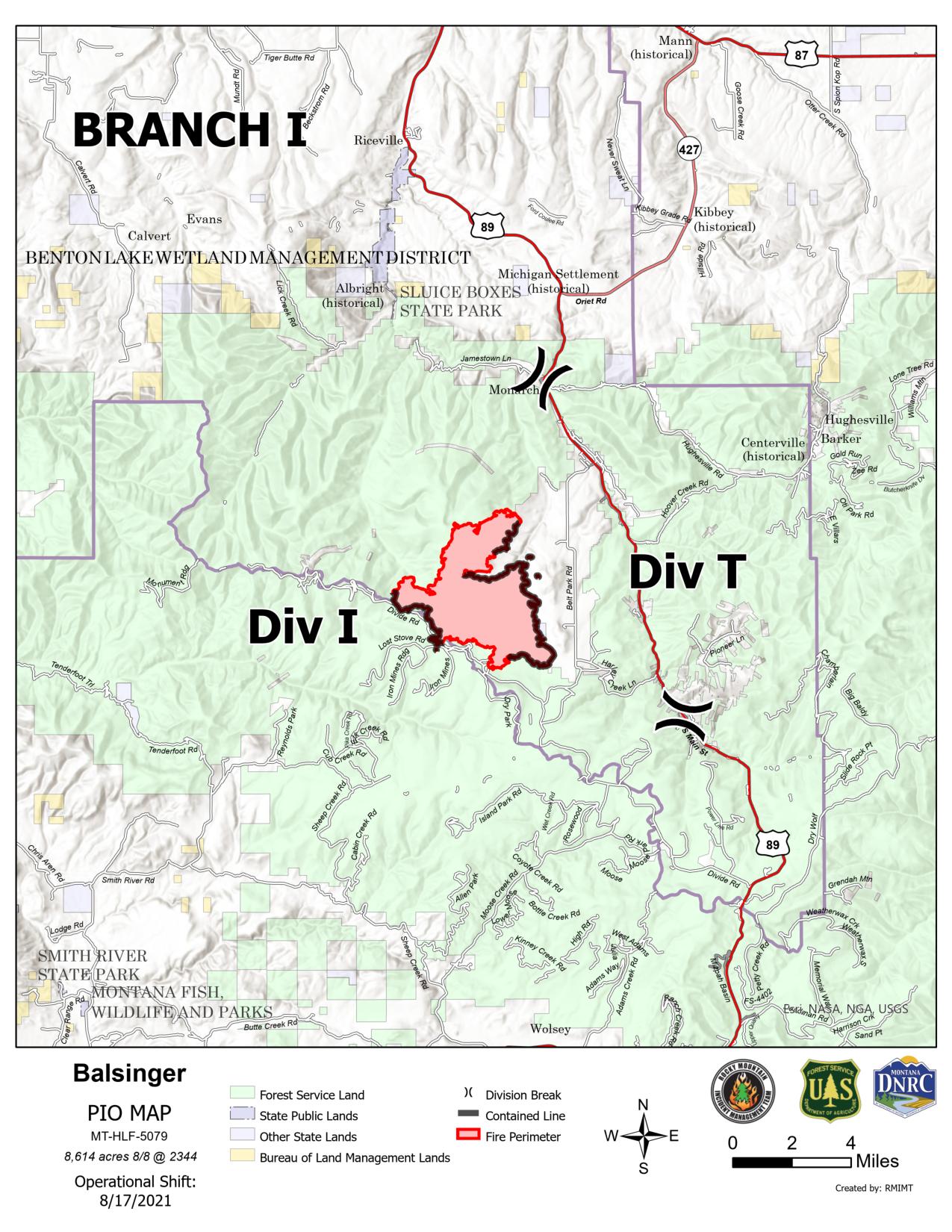
Acreage: 8,614 | Containment: 50% | Start date: July 9, 2021 | Cause: Lightning | Personnel: 155
The Balsinger Fire is burning approximately five miles west of Neihart, Montana. Most of the operation yesterday was on the south end of the fire in Division I. The fire remained in its footprint. Firefighters today will continue to work on the section of uncontained line in that division. One initial attack module worked on the uncontained portion of Division T yesterday and will continue today mopping up and securing that edge. Patrols continue near Monarch. The UAS (firefighting drone) scouted the north edge of the fire yesterday using infrared heat detection. Today, it will fly the northwest edge, then move to the northeast to identify any hot spots.
Woods Creek Fire
Acreage: 54,973 | Containment: 43% | Start date: July 10, 2021 | Cause: Lightning | Personnel: 602
The Woods Creek Fire is in the Big Belt Mountains, approximately 16 miles northeast of Townsend, Montana. Most of the fire activity yesterday was in the north end near the division break with AA. Firefighters continue to keep that in check. Work continues in that division today, finishing indirect line going north and adding some toward Division YY. Two additional hotshot crews will be in that area today, scouting opportunities for direct attack along the northern edge of the fire and building hand line anchored to the existing containment edge. Containment along the eastern edge is secure and will be patrolled today. Crews are working to contain the remaining line near Big Birch Creek, mopping up and protecting cabins in that area. Indirect line is now complete along the southwest edge of the fire near Windy Ridge and will be reinforced today. Fire officials are examining indirect attack options in Division PP. In Divisions QQ and SS, indirect line is complete. Today, crews will clear vegetation along that line. Smokes will be visible on this western edge, but firefighter preparation, prevailing winds, and limited fuels are keeping the fire in check. In Division WW the plan today is securing line by the break with Division SS and mopping up, using a dozer to support the two crews in that area. In Division YY, crews are working on contingency line, working toward Watson Meadow with a dozer.
Weather and Fuel Conditions: Today and tomorrow will be hot, dry, and windy. The predicted high temperature today is 80°F at 7500 feet elevation. Humidity may be as low as 13%. Strong ridgetop winds are expected, with gusts up to 20 mph. With several days of high temperatures and poor nighttime humidity recoveries, fuels are extremely dry. Some parts of the fires are making short runs, but they are limited by fine fuels and lack of wind alignment with the terrain. Cooler, wetter weather is forecast starting Tuesday.
Evacuation Notices
American Fork Fire: The Park County Sheriff’s Office has Shields River Road in pre-evacuation status. Meagher County has done the same with the Smith Creek area. County roads in the area are open. However, there are still closures in the national forests.
Balsinger Fire: An evacuation order for Belt Park issued by the Cascade County Sheriff’s Office remains in place. There is a pre-evacuation order for the area from the Belt Creek Ranger Station to Monarch and from west of Monarch to the confluence of Pilgrim Creek and Belt Creek.
Woods Creek Fire: Effective August 11, the Broadwater County Sheriff’s Office lifted the evacuation order covering everything east of Highway 284 between Gravely Lane in the north and Dry Gulch Road in the south. Highway 284 remains open. Residents of Upper Duck Creek Road, Upper Gurnett Creek Road, Upper Confederate Road, Ambush Drive, Battle Drive and from Upper Gurnett to White’s Gulch east and west of Highway 284 may return to their homes. All areas are currently in pre-evacuation. A mandatory evacuation of six cabins and Big Birch Creek is in place. The Meagher County Sheriff’s Office issued a pre-evacuation notice for residents on Birky Road and Ramspeck Lane and for Grassy Mountain residents.
Closures and Advisories
Areas around the fires are closed for public safety. Please respect the closure signs.
Temporary flight restrictions (TFRs) remain in place on all three fire areas. The TFR for the Woods Creek Fire now extends further to the north. TFR violations can disrupt aerial firefighting operations and may force fire managers to ground essential aircraft. Wildfires are a no-fly zone for unauthorized aircraft, including drones. If you fly, we can’t. http://knowbeforeyoufly.org.
Most of the Helena-Lewis and Clark National Forest is in Stage 2 fire restrictions. There are also closure areas for the Balsinger and Woods Creek fires. See: https://www.fs.usda.gov/alerts/hlcnf/alerts-notices
Stage 1 fire restrictions remain in place for the Custer Gallatin National Forest. There is also a closure area for the American Fork fire. See: https://www.fs.usda.gov/alerts/custergallatin/alerts-notices
The Bureau of Land Management Butte and Lewiston Field Offices issued an area closure for lands affected by the Woods Creek Fire. See: https://inciweb.nwcg.gov/incident/article/7649/63667/
Daily Fire Update 8162021
Related Incident:
Publication Type: News
American Fork, Balsinger, and Woods Creek Fires Update
Monday, August 16, 2021 – 9 a.m.
Rocky Mountain Type 1 Incident Management Team
Dan Dallas, Incident Commander
Information phone: 406-426-9612
Email: 2021.divide@firenet.gov
Information staffing hours: 8:00 am – 8:00 pm
Special Note: There is a red flag warning for fire weather today. Use caution to prevent new fire starts.
Current Situation: Fire behavior was moderate yesterday, despite the dry, windy weather. Winds did not align with the terrain for any major fire runs. Winds are shifting today with continued warm, dry conditions. Firefighters are watching for potential spotting on the north edges of the American Fork and Woods Creek Fires with the changing wind direction. Work continues today on securing existing containment lines, direct attack where feasible, and constructing and clearing indirect and contingency lines. Night patrols continue, staffing the fire around the clock.
American Fork Fire
Acreage: 20,718 | Containment: 57% | Start date: July 17, 2021 | Cause: Lightning | Personnel: 90
The American Fork Fire is burning in the central part of the Crazy Mountains, approximately 24 miles southwest of Harlowton, Montana. An initial attack crew dug direct line yesterday in Division M, working west from the containment line at the break with Division P. Another crew did the same in Division P, working southeast along the perimeter toward Division A. Today, crews continue in the Buck Creek drainage, working east toward Division A, aiming to contain the entire south edge of the fire. On the north edge in Division M, they will anchor off the Shields River Road today, working northeast toward the Blacktail Fire scar. There are unburned pockets of fuels in the “fingers” on the north edge of the fire. Firefighters will use UAS (firefighting drones) today for infrared detection of hot spots and possibly to burn out some of those islands of fuels before the predicted weather change.
Balsinger Fire
Acreage: 8,614 | Containment: 52% | Start date: July 9, 2021 | Cause: Lightning | Personnel: 145
The Balsinger Fire is in the Little Belt Mountains, approximately five miles west of Neihart, Montana. Firefighters increased containment yesterday in the northwest portion of Divisions T and along the Divide Road in Division I. There is generally less heat and active fire behavior on this fire than the other two, but yesterday saw some hot spots and torching trees. Today, crews will mop up and secure the new containment line. In Division I. the objective is to add containment and address any hot spots along the southern edge of the fire, near Wilson Creek and Iron Mountain.
Woods Creek Fire
Acreage: 55,729 | Containment: 43% | Start date: July 10, 2021 | Cause: Lightning | Personnel: 540
The Woods Creek Fire is burning in the Big Belt Mountains, approximately 16 miles northeast of Townsend, Montana. There were small spot fires yesterday on the north edge in Division AA. A hotshot crew controlled these spots, then anchored to the containment line along the North Fork of Elk Creek, working south with heavy support from aircraft to mitigate fire behavior. They constructed a small piece of indirect line and used firing operations to burn out fuels yesterday evening. They camped in the area overnight and will continue working south today with direct line, and also building a smaller contingency line to the north. Containment line in Divisions AA and OO is secure and in patrol status. Another spot fire occurred yesterday in heavy timber mixed with light grasses on the southeast edge of the fire in the uncontained portion of Division OO. Three dozers and a helicopter addressed the spot and kept it controlled. Fire officials are examining indirect attack options in Division PP and crews are strengthening and clearing the indirect line in Divisions QQ and SS, using existing roads and tying into the forest boundary. They are also completing a safety zone in Division SS, which is an enlarged area integral to a fuel break that can protect firefighters and equipment in case of rapidly increasing fire activity. Firefighters added containment yesterday in Division YY near Confederate Gulch Road. Two other hotshot crews are anchoring to that containment line, working east toward Division AA. Firefighters are also constructing contingency line along the northern edge of the fire and may burn out small pockets of fuel today. Air support today will focus on the Woods Creek fire in Divisions AA and OO.
Weather and Fuel Conditions: Today will again be warm, dry, and windy. The predicted high temperature is 77°F at 7500 feet elevation. Humidity may be as low as 20%. Strong ridgetop winds, 15-25 mph, are expected from the southwest, with gusts up to 40 mph, especially near the American Fork Fire. Tomorrow, a strong cold front will bring cooler weather with an 80% chance of up to an inch of rain in some locations. Wind direction will change to the north. After three nights of poor humidity recovery, fuels are extremely dry. The change in winds this afternoon could provoke increasing fire behavior and there is a possibility of some dry lightning strikes.
Evacuation Notices
American Fork Fire: The Park County Sheriff’s Office has Shields River Road in pre-evacuation status. Meagher County has done the same with the Smith Creek area. County roads in the area are open. However, there are still closures in the National Forests.
Balsinger Fire: An evacuation order for Belt Park, issued by the Cascade County Sheriff’s Office, remains in place. There is a pre-evacuation order for the area from the Belt Creek Ranger Station to Monarch and from west of Monarch to the confluence of Pilgrim Creek and Belt Creek.
Woods Creek Fire: Effective August 11, the Broadwater County Sheriff’s Office lifted the evacuation order covering everything east of Highway 284 between Gravely Lane in the north and Dry Gulch Road in the south. Highway 284 remains open. Residents of Upper Duck Creek Road, Upper Gurnett Creek Road, Upper Confederate Road, Ambush Drive, Battle Drive and from Upper Gurnett to White’s Gulch east and west of Highway 284 may return to their homes. All areas are currently in pre-evacuation. A mandatory evacuation of six cabins and Big Birch Creek is in place. The Meagher County Sheriff’s Office issued a pre-evacuation notice for residents on Birky Road and Ramspeck Lane and for Grassy Mountain residents.
Closures and Advisories
Areas around the fires are closed for public safety. Please respect the closure signs.
Temporary flight restrictions (TFRs) remain in place on all three fire areas. TFR violations can disrupt aerial firefighting operations and may force fire managers to ground essential aircraft. Wildfires are a no-fly zone for unauthorized aircraft, including drones. If you fly, we can’t. http://knowbeforeyoufly.org
Most of the Helena-Lewis and Clark National Forest is in Stage 2 fire restrictions. There are also closure areas for the Balsinger and Woods Creek fires. See: https://www.fs.usda.gov/alerts/hlcnf/alerts-notices
Stage 1 fire restrictions remain in place for the Custer Gallatin National Forest. There is also a closure area for the American Fork fire. See: https://www.fs.usda.gov/alerts/custergallatin/alerts-notices
The Bureau of Land Management Butte and Lewiston Field Offices issued an area closure for lands affected by the Woods Creek Fire. See: https://inciweb.nwcg.gov/incident/article/7649/63667/
Daily Fire Update 08172021
Related Incident:
Publication Type: News
American Fork, Balsinger, and Woods Creek Fires Update
Tuesday, August 17, 2021 – 9 a.m.
Rocky Mountain Type 1 Incident Management Team
Dan Dallas, Incident Commander
Information phone: 406-426-9612
Email: 2021.divide@firenet.gov
Information staffing hours: 8:00 am – 8:00 pm
Special Note: A virtual community meeting will be held on Facebook Live this evening at 8:00pm. Join us with your questions at https://bit.ly/WoodsCkBalsingerAmForkFires
Current Situation: Windy, dry conditions yesterday brought active fire behavior. There were smokes near fire lines and spots over the lines in some places. Despite this activity, firefighters increased containment on two of the fires and kept all new spots contained. Today brings a cold front with gusty winds and the potential for rain. Work continues today on securing existing containment lines, direct attack where feasible, and constructing and clearing indirect and contingency lines. Night patrols continue, staffing the fire around the clock. Helicopters flew 53 hours yesterday, supporting crews on the ground. Today, they hope to get the two fixed-wing air attack platforms up with the clearer skies.
American Fork Fire
Acreage: 20,741 | Containment: 57% | Start date: July 17, 2021 | Cause: Lightning | Personnel: 79
The American Fork Fire is burning in the central part of the Crazy Mountains, approximately 24 miles southwest of Harlowton, Montana. This fire got the strongest winds yesterday and the northern edge was especially active. Firefighters constructed direct line in Division M, working east from Crandall Creek toward Dugout Creek. Today, fire weather will be similar to yesterday before the cold front passes through. Crews will work along the north edge, anchoring from the containment line near Crandall Creek and pushing east to Shields River Road. There is interior fire activity near Lebo Peak, burning toward the Blacktail Fire scar, which provides a natural barrier to further spread. The south end of the fire also had some interior burning near Buck Creek. In Division P, firefighters are using direct attack to contain the remaining line near Buck Creek. Today, crews will construct direct line southeast of River Road working toward Buck Creek Road. The fire slopped over yesterday in a timber stringer in Division A. Dozer line was already in place and crews will put out the spot today.
Balsinger Fire
Acreage: 8,614 | Containment: 68% | Start date: July 9, 2021 | Cause: Lightning | Personnel: 128
The Balsinger Fire is in the Little Belt Mountains, approximately five miles west of Neihart, Montana. Firefighters increased containment yesterday in the northeast part of the fire in Division T and at the southwest in Division I. The plan today is to secure, mop up, and patrol these areas. Firefighters will concentrate today and tomorrow on the southern edge, working to contain the remaining line. There was a spot fire yesterday to the east in Division I that firefighters contained. Crews today will hike in south of Thunder Mountain to put out a hot spot on the northern edge.
Woods Creek Fire
Acreage: 55,834 | Containment: 47% | Start date: July 10, 2021 | Cause: Lightning | Personnel: 526
The Woods Creek Fire is burning in the Big Belt Mountains, approximately 16 miles northeast of Townsend, Montana. A hotshot crew continues direct attack in Division AA, working south from the containment line along the North Fork of Elk Creek. Contingency line is in place in this division, tied into the break with Division YY. Crews started on a smaller section of alternate line along Cement Gulch and Lucky Gulch. Crews continue to patrol, mop up, and secure the containment line along the eastern edge of the fire and are working to contain the hot spot near Big Birch Creek, which hasn’t moved but is still hot. At the southeast edge near Russell Fork Deep Creek, the fire pushed to the east yesterday, but crews were able to keep it in check with dozer line. Northerly winds today could push the fire south in Divisions SS and QQ but firefighters have constructed, and continue to improve, indirect line along that edge of the fire. In Division SS they are completing chipping operations and the safety zone today. In Division YY, another hotshot crew is constructing direct line to the east, working toward Division AA, with a third hotshot crew in-between. They are improving the indirect contingency line along the north edge of the fire, tied into Watson Meadow.
Weather and Fuel Conditions: This morning will be dry and windy before the predicted cold front arrives in the late morning to afternoon over the Balsinger and Woods Creek Fires, then later in the day over the American Fork Fire. The high temperature will be 67°F at 7500 feet elevation. Winds will be out of the north, with gusts up to 30 mph, especially near the American Fork Fire. Windy conditions and dry fuels will keep fire behavior active until the rains arrive. Strong northerly winds may align with hot spots, driving potential fire runs. Tomorrow, the forecast is for continued rain showers and even cooler temperatures.
Evacuation Notices
American Fork Fire: The Park County Sheriff’s Office has Shields River Road in pre-evacuation status. Meagher County has done the same with the Smith Creek area. County roads in the area are open. However, there are still closures in the National Forests.
Balsinger Fire: An evacuation order for Belt Park, issued by the Cascade County Sheriff’s Office, remains in place. There is a pre-evacuation order for the area from the Belt Creek Ranger Station to Monarch and from west of Monarch to the confluence of Pilgrim Creek and Belt Creek.
Woods Creek Fire: Effective August 11, the Broadwater County Sheriff’s Office lifted the evacuation order covering everything east of Highway 284 between Gravely Lane in the north and Dry Gulch Road in the south. Highway 284 remains open. Residents of Upper Duck Creek Road, Upper Gurnett Creek Road, Upper Confederate Road, Ambush Drive, Battle Drive and from Upper Gurnett to White’s Gulch east and west of Highway 284 may return to their homes. All areas are currently in pre-evacuation. A mandatory evacuation of six cabins and Big Birch Creek is in place. The Meagher County Sheriff’s Office issued a pre-evacuation notice for residents on Birky Road and Ramspeck Lane and for Grassy Mountain residents.
Closures and Advisories
Areas around the fires are closed for public safety. Please respect the closure signs.
Temporary flight restrictions (TFRs) remain in place on all three fire areas. TFR violations can disrupt aerial firefighting operations and may force fire managers to ground essential aircraft. Wildfires are a no-fly zone for unauthorized aircraft, including drones. If you fly, we can’t. http://knowbeforeyoufly.org
Most of the Helena-Lewis and Clark National Forest is in Stage 2 fire restrictions. There are also closure areas for the Balsinger and Woods Creek fires. See: https://www.fs.usda.gov/alerts/hlcnf/alerts-notices
Stage 1 fire restrictions remain in place for the Custer Gallatin National Forest. There is also a closure area for the American Fork fire. See: https://www.fs.usda.gov/alerts/custergallatin/alerts-notices
The Bureau of Land Management Butte and Lewiston Field Offices issued an area closure for lands affected by the Woods Creek Fire. See: https://inciweb.nwcg.gov/incident/article/7649/63667/
Daily Fire Update 08182021
Related Incident:
Publication Type: News
American Fork, Balsinger, and Woods Creek Fires Update
Wednesday, August 18, 2021 – 10:00 a.m.
Rocky Mountain Type 1 Incident Management Team
Dan Dallas, Incident Commander
Information phone: 406-426-9612
Email: 2021.divide@firenet.gov
Information staffing hours: 8:00 am – 8:00 pm
Current Situation: A strong cold front came into the fire area from the north yesterday, bringing high winds, cooler temperatures, and rain showers. This weather pattern is expected to continue for several days, dampening fire behavior and providing firefighters an opportunity to increase containment on all three fires. The Balsinger and Woods Creek fires saw additional containment yesterday. Night patrols continue, staffing the fires around the clock.
American Fork Fire
Acreage: 21,876 | Containment: 57% | Start date: July 17, 2021 | Cause: Lightning | Personnel: 99
The American Fork Fire is burning in the central part of the Crazy Mountains, approximately 24 miles southwest of Harlowton, Montana. Yesterday, in Division A, engines and aerial resources supported mop up of a small slop-over fire. Crews patrolled and added more depth to containment line along the southern edge. Firefighters are working on the small piece of uncontained line near Buck Creek. Progress is slow because of difficult terrain; they will continue today with direct attack. On the west side, in Division P, crews are patrolling, mopping up, and adding depth to the containment line. Line is in place at the north edge in Division M from Crandall Creek Road to Shields River Road. Work today will be on improving that section. A new anchor point is now established by Dugout Creek so firefighters can go direct, working north toward the Blacktail Fire scar. They burned out a pocket of fuels in that area yesterday. Active fire behavior continues in the northern “fingers” but is not hampering the overall suppression effort. Firefighters are engaging the southern and eastern uncontained areas, with the objective of fully containing these in the next several days.
Balsinger Fire
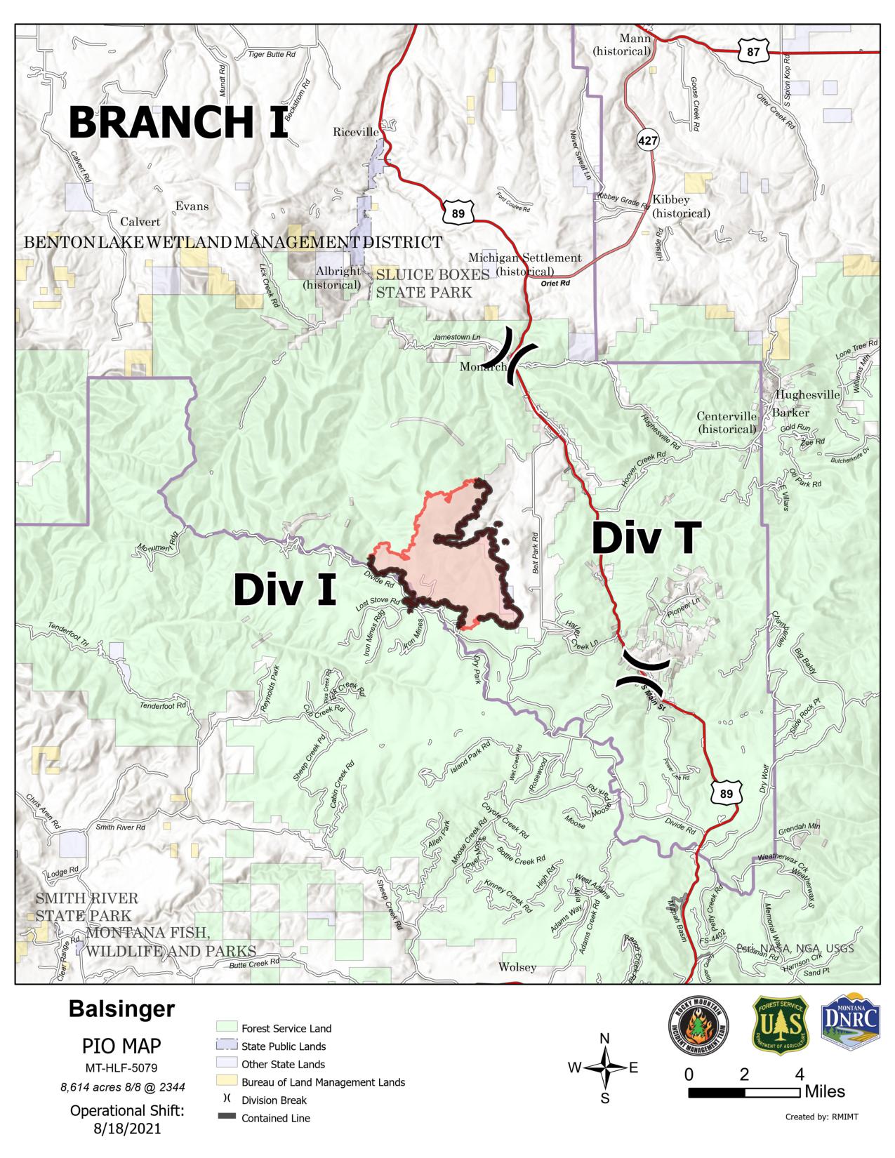
Acreage: 8,614 | Containment: 70% | Start date: July 9, 2021 | Cause: Lightning | Personnel: 126
The Balsinger Fire is in the Little Belt Mountains, approximately five miles west of Neihart, Montana. The cold front reached this fire early in the day, limiting fire behavior and spread. Firefighters increased containment yesterday on the south edge in Division I. On the west side, near Pilgrim Creek, crews hiked in south of Thunder Mountain to put check line around a one-acre hot spot. On the east side in Division T, the focus is on improving the existing containment line. Crews are patrolling the containment line in Division I. Over the next few days, the goal is to fully contain the south edge of the fire. Fire officials are examining options for the northern edge.
Woods Creek Fire
Acreage: 55,834 | Containment: 49% | Start date: July 10, 2021 | Cause: Lightning | Personnel: 538
The Woods Creek Fire is burning in the Big Belt Mountains, approximately 16 miles northeast of Townsend, Montana. A hotshot crew continues direct attack in Division AA, working south from the containment line along the North Fork of Elk Creek. They placed hose lays and national guard crews are working behind them, mopping up. In Division YY, another hotshot crew is constructing direct line to the east, working toward Division AA, with a third hotshot crew in-between, working west. The goal is full containment of the northern edge in the next several days and improvement of the indirect and contingency lines. In Division OO, firefighters tied indirect line to the boundary of the Helena National Forest yesterday, using dozers and feller-bunchers. Wind hit late in the morning and pushed the fire around in this area before the rain arrived; however, crews kept it contained. There was very little fire behavior or visible smoke yesterday in Division QQ. Crews strengthened indirect line there and tied into the burn scar to the east. In Division SS, the fire hasn’t moved in several days.
There is a little heat in the area near North Fork Duck Creek. Yesterday firefighters extinguished a persistent smoke that was visible in that area from the southwest. Crews in Division YY reinforced and strengthened line at the western edge. On the east edge, crews will monitor, patrol and strengthen the containment edge, and work to contain the remaining piece of line near Big Birch Creek. They have started suppression repair in this area, mitigating the effects of fire suppression activities on natural and cultural resources. The plan for the next several days is to continue work at the south edge, where it is safe to do so in the steep, rocky terrain. In the unlikely event of fire growth in Divisions SS or QQ, firefighters can burn out fuels from the indirect line they constructed.
Weather and Fuel Conditions: Cool, wet weather is forecast to remain in the area through Saturday. The high temperature today will be 45°F at 7500 feet elevation. There is an 80% chance of rain. Winds are from the north, gusting up to 25 mph.
Evacuation Notices
The interactive web map now depicts evacuation areas. Please see https://bit.ly/WoodsCreekBalsingerAmericanForkFires or contact your local county sheriff’s office for details.
American Fork Fire: The Park County Sheriff’s Office has Shields River Road in pre-evacuation status. Meagher County has done the same with the Smith Creek area. County roads in the area are open. However, there are still closures in the National Forests.
Balsinger Fire: An evacuation order for Belt Park, issued by the Cascade County Sheriff’s Office, remains in place. There is a pre-evacuation order for the area from the Belt Creek Ranger Station to Monarch and from west of Monarch to the confluence of Pilgrim Creek and Belt Creek.
Woods Creek Fire: Effective August 11, the Broadwater County Sheriff’s Office lifted the evacuation order covering everything east of Highway 284 between Gravely Lane in the north and Dry Gulch Road in the south. Highway 284 remains open. Residents of Upper Duck Creek Road, Upper Gurnett Creek Road, Upper Confederate Road, Ambush Drive, Battle Drive and from Upper Gurnett to White’s Gulch east and west of Highway 284 may return to their homes. All areas are currently in pre-evacuation. A mandatory evacuation of six cabins and Big Birch Creek is in place. The Meagher County Sheriff’s Office issued a pre-evacuation notice for residents on Birky Road and Ramspeck Lane and for Grassy Mountain residents.
Closures and Advisories
Areas around the fires are closed for public safety. Please respect the closure signs.
Temporary flight restrictions (TFRs) remain in place on all three fire areas. TFR violations can disrupt aerial firefighting operations and may force fire managers to ground essential aircraft. Wildfires are a no-fly zone for unauthorized aircraft, including drones. If you fly, we can’t. http://knowbeforeyoufly.org
Most of the Helena-Lewis and Clark National Forest is in Stage 2 fire restrictions. There are also closure areas for the Balsinger and Woods Creek fires. See: https://www.fs.usda.gov/alerts/hlcnf/alerts-notices
Stage 1 fire restrictions remain in place for the Custer Gallatin National Forest. There is also a closure area for the American Fork fire. See: https://www.fs.usda.gov/alerts/custergallatin/alerts-notices
The Bureau of Land Management Butte and Lewiston Field Offices issued an area closure for lands affected by the Woods Creek Fire. See: https://inciweb.nwcg.gov/incident/article/7649/63667/