
Incident Publication
Emergency Bootleg Fire closure expanded Lake County Level 3 evacuations
Related Incident:
Publication Type: Announcement
The emergency closure or the Bootleg Fire area on the Fremont-Winema National Forest was expanded for the second time in a week due to increased fire activity and movement.
Additionally, the Lake County Sheriff’s Office of Emergency Management has identified areas for Level 3 (Go Now), Level 2 (Get Set) and Level 1 (Be Ready) in western Lake County due to the fire, and is notifying residents and recreating public in the Level 3 area.
Lake County Evacuations
Level 3 (Go Now)
• South of the Sycan River, south of Forest Roads 3239 and 28, and the Gearhart Wilderness west of Forest Road 3372 in Lake County.
Level 2 (Get Set)
• Sycan Marsh area, Chocktoot Creek Drainage area, west of Forest Road 28 and east of Forest Road 3372, north of Forest Road 34, and through the area that includes Corral Creek Campground and Mitchell Monument.
Level 1 (Be Ready)
• From the northeast at the Lake County line, through the Yamsay Mountain Recreation Area, extending east to the south of Thompson Reservoir to Winter Rim Recreation Area, then south near the Forest Boundary, then following Chewaucan Road south to Forest Road 34.
The evacuation levels include recreation sites in the Fremont-Winema National Forest, as well as private property.
The expanded forest closure order is on National Forest System lands south of Silver Lake Road between U.S. Highway 97 and Oregon State Highway 31; west of Oregon State Highway 31 and U.S. Highway 395; north of the Oregon-California Stateline; northeast of Willow Valley Road, Langell Valley Road, Bly Mountain Cutoff Road, Oregon State Highway 140 and Sprague River Road to U.S. Highway 97; and east of U.S. Highway 97 between Chiloquin and Silver Lake Road.
All roads, recreation sites and facilities are closed within the closure area.
“The Bootleg Fire has moved rapidly through Klamath and Lake counties, with extreme fire behavior driven by hot weather, winds and exceptionally dry fuels since it was discovered last Tuesday,” said Fremont-Winema National Forest Supervisor Barry Imler. “For public and firefighter safety, it is essential that we expand the closure area while firefighters, the Incident Management Team and area fire managers work together to contain and control the fire.”
The closure order is formally referenced as 06-02-21-05. It went into effect Monday night and is in effect until conditions allow or December 31, 2021, whichever occurs first. There will be public notifications when the closure order is lifted.
Area residents and Forest visitors are asked to avoid the fire area and related roads while suppression activities continue. Anyone driving in the area should watch for increased traffic and vehicles associated with wildland firefighting.
Violations of the closure order are punishable by a fine of not more than $5,000 for an individual or $10,000 for an organization, or imprisonment of not more than 6 months or both.
Bootleg Fire Information Update Tuesday July 13 2021 at 10 AM
Related Incident:
Publication Type: News
The Bootleg Fire burned another 50,000 acres yesterday. Infrared mapping shows the fire size at 201,923 acres. The fire grew by more than three miles, fueled by extreme drought conditions, single digit humidity, and high temperatures.
The weather forecast shows little signs of relief. The National Weather Service issued a red flag warning through 8:00 p.m. on Wednesday. A heat advisory has also been issued until 8:00 p.m. on Tuesday. Fire managers noted the potential for rapid spread in the coming days.
Al Lawson, Incident Commander of PNW Team 10 encouraged the firefighters to adjust their expectations to the new conditions. “As you go out there today—adjust your reality. We have not seen a fire move like this, in these conditions, this early in the year. Expect the fire to do things that you have not seen before.”
Bootleg Fire South Zone (Zone 1)
A new fire started in the Moccasin Hills area yesterday and led to the evacuation of several residents. Local firefighters, both structural and wildland crews, and air support teamed up and quickly suppressed the five-acre fire.
On the southern edge of the fire, crews were successful in keeping the main fire out of populated areas. The fire burned mostly toward the southeast yesterday. Crews built six miles of dozer line toward Obenchain Reservoir. Firefighters continued to connect and improve dozer lines, install hose lays to extinguish hot spots near structures and along the control, and assess and remove fire damaged trees.
The fire is impacting a high-voltage transmission line. Fire officials and representatives with the power companies are working together on plans to safely re-energize the lines as soon as possible.
Bootleg Fire North Zone (Zone 2):
Fire crews on the North Zone of the fire identified and began to suppress three new fires totaling 150 acres in the Summer Lake area. These crews also built dozer line and set up hose lays to keep the fire west of Forest Road 28.
On the fire’s western flank, crews made good progress in improving dozer line and extinguishing hot spots. Last night, crews continued preparations for burn-out operations down the western slope of Fuego Mountain. Along the northern flank, crews are scouting new locations for safe, effective primary and secondary containment lines.
Oregon Office of State Fire Marshal’s Update:
Yesterday, structural fire crews identified and extinguished spot fires around structures. Firefighters on the northeast side of the fire helped safeguard 11 people when winds pushed the fire toward them. Residents and firefighters retreated into a meadow, a safety zone. Once the fire passed, firefighters returned to the area and continued firefighting around the structures. These firefighters also assisted residents in two vehicles when they became trapped by the fire and were unable to escape because of downed trees. The firefighters removed the trees from the roadway, allowing the group to safely escape.
Other crews extinguished small fires around structures along the fire’s south end.
Estimated Size: 201,923 acres
Containment: 0%
Start Date/Time: 07/06/2021
Location: 15 miles NW of Beatty, Ore.
Cause: Under investigation
Personnel: 1,189
Assigned Resources
Hand Crews: 22
Engines: 133
Dozers: 11
Water Tenders: 32
Other Heavy Equipment: 3
Assigned Aircraft: 14
Structure Task Forces: 10
Structures Threatened: 1,926
Evacuations: Level 3 (GO)
Level 2 (BE SET)
Level 1 (BE READY)
Evacuations: Lake County (NEW)
Level 3 (GO NOW) Evacuation Notice
• South of the Sycan River, south of Forest Roads 3239 and 28, and the Gearhart Wilderness west of Forest Road 3372 in Lake County.
Level 2 (GET SET) Evacuation Notice
• Sycan Marsh area, Chocktoot Creek Drainage area, west of Forest Road 28 and east of Forest Road 3372, north of Forest Road 34, and through the area that includes Corral Creek Campground and Mitchell Monument.
Level 1 (BE READY) Evacuation Notice
• From the northeast at the Lake County line, through the Yamsay Mountain Recreation Area, extending east to the south of Thompson Reservoir to Winter Rim Recreation Area, then south near the Forest Boundary, then following Chewaucan Road south to Forest Road 34.
Evacuations: Klamath County (will change on 7/13/21)
Level 3 (GO NOW) Evacuation Notice
• Klamath County, north of the town of Beatty. East side of Godowa Springs Rd north of the OC and E Trail to the Klamath County Line need to leave immediately.
• Klamath County, near the town of Sprague River. Upper tableland area north of Oregon Pines Rd need to leave immediately.
Level 2 (GET SET) Evacuation Notice
• Klamath County, near the town of Sprague River. Klamath Forrest Estates/Moccasin Hills Area need to be prepared to leave.
• Klamath County, West side of Godowa Springs Rd, south of Oregon Pines Rd and Tableland Rd. to the river need to be prepared to leave.
Level 1 (BE READY) Evacuation Notice
• Klamath County, Between Beatty and Bly 3 miles south of Highway 140 from Yellow Jacket Springs to Fishhole Creek need to be ready in case.
• Klamath County, the area from the intersection of Sprague River Rd and Forbes Rd extending east to Godowa Springs and Yellow Jacket Springs and south of the Sprague River 4 miles need to be ready in case.
The Klamath County Sheriff’s Office started to issue citations and will make arrests if necessary to keep people out of the Level 3 evacuation areas.
Closures
The Fremont-Winema National Forest is closed to the public in the fire area. See updated map and the Emergency Fire Closure Order 06-02-21-05 on Inciweb at https://inciweb.nwcg.gov/incident/7609/ or on the forest’s website at www.fs.usda.gov/alerts/Fremont-winema/alerts-notices.
Smoke
New fires in Oregon and northern California are contributing to smoke from the Bootleg Fire, with the probability of increasing the smoke layer. If you are sensitive to smoke, check air quality levels at: https://fires.airfire.org/outlooks/southcentraloregon.
Fire Prevention
With Red Flag Warnings early this week, and exceptionally dry conditions, it is critical that area residents and visitors are extremely careful with anything that can potentially spark a wildfire. This includes not driving or parking on dry grass, following public and regulated use restrictions, ensuring chains aren’t dragging and that tires are properly inflated. A small spark can quickly become a large wildfire in minutes.
If you suspect a wildfire, please call 911 to report it immediately. Help our firefighters focus on the Bootleg Fire and not having to respond to new starts!
Bootleg Fire Daily Update July 14
Related Incident:
Publication Type: News
Location: 28 miles northeast of Klamath Falls, OR
Size: 212,377 acres
Containment: 5%
Personnel: 1,338
Dry and windy conditions contributed to another day of active fire behavior on the Bootleg Fire burning in Southern Oregon. Firefighters reported growth primarily to the east in the greater Gearhart Wilderness area. Air operations were severely limited due to unsafe flying conditions in heavy smoke.
“We’re making steady progress where winds and terrain allow,” said Rob Allen, Incident Commander for PNW2 Incident Management Team. “But for the third day in a row, firefighters had to disengage at times for their safety and weather isn’t going to change for the foreseeable future.”
On the ground, firefighters improved existing dozer and hand containment lines in the Fuego Mountain area. Crews took advantage of favorable conditions overnight to ‘burnout’ along these lines, significantly diminishing the potential for future fire growth toward the west in future weeks and leaving a solid containment line for the community of Chiloquin and Highway 97 in the area.
To the south and east, crews took advantage of yesterday’s inversion to make continued progress on improving dozer and other containment lines. Crews conducted ‘burnout’ operations overnight to strengthen those lines and increase containment. While the fire did not make expansive ‘runs’ as it did in past days, west winds continued to push fire growth toward the greater Snake and Round Butte areas under Red Flag conditions.
Community Meeting: Please join us for a virtual community meeting July 14, 2021 at 6:30pm at www.facebook.com/BootlegFireInfo.
Evacuations: Evacuations are rapidly changing due to the nature of this wildfire. Please visit tinyurl.com/bootlegevac for an interactive map of evacuation level in Lake and Klamath Counties.
Closures: The Fremont-Winema National Forest is closed to the public in the fire area. Map and full order available at inciweb.nwcg.gov/incident/7609/.
Smoke: Heavy smoke expected July 14, 2021 with widespread impacts to communities and State Route 140 in Oregon between Chiloquin and Bly. Full report at: fires.airfire.org/outlooks/southcentraloregon.
Fire Information Public Phone: 541-482-1331
Fire Information Media Phone: 971-727-7255
Facebook: www.facebook.com/BootlegFireInfo
Twitter: twitter.com/BootlegFireInfo
Hashtags: #BootlegFire #FireYear2021
Smoke Outlook for South Central Oregon 714715
Related Incident:
Publication Type: Announcement
Below is the Smoke Outlook for South Central Oregon including the Bootleg Fire for July 14-15.
Update on the Log Fire Northeast of the Bootleg Fire July 14
Related Incident:
Publication Type: News
The Log Fire, currently estimated at 2,800 acres, is approximately 25 miles south of Silver Lake, OR and was found on July 12, 2021 at 0600. The Log Fire was originally three independent fires. Firefighters were initially able to secure line around the fires, but due to the extremely dry fuels and challenging weather conditions, the fire spotted over these initial containment lines. Today, additional crews are working to strengthen line around Trunk Road/28 Road. Crews have been working day and night, with more advantageous firefighting conditions during the overnight hours. Firefighter priority is to contain this area and keep the fire from moving east.
CHANGES TO EVACUATION LEVELS FOR THE BOOTLEG FIRE
Related Incident:
Publication Type: Announcement
Klamath County Sheriff’s Office and Klamath County Emergency Management working with the Incident Management Teams for the Bootleg Fire in eastern Klamath County have made the decision to modify the following evacuation levels effective at 2:00PM July 14, 2021:
LEVEL 3 reducing to LEVEL 2
Sprague River. Upper tableland area north of Oregon Pines Rd is being reduced to a Level 2 (GET SET) evacuation notice.
Beatty, north. East side of Godowa Springs Rd south from the transition with forest service road 3462 to highway 140. is being reduced to a Level 2 (GET SET) evacuation notice.
LEVEL 1 New
Near Yamsi Ranch. Williamson River Rd from the intersection of forest service road 46 and forest service road 44 extending north approximately 8 miles.
The Klamath County Bootleg Map interactive online map shows these changes at https://kcgis.maps.arcgis.com/apps/webappviewer/index.html?id=4bfb02b41eb7473ca95b04c3cbd1da2.1
For residents returning into previously evacuated areas it would be a good idea to visit your property first and make certain fences are intact before bringing livestock back with you. In addition, understand that power crews may be working in the area and power or other services may be intermittent as the general area still has fire activity.
Drive carefully and be aware that fire crews are still in the area. Also as well as be aware of down or severely damaged trees.
Level 1 - (BE READY) for potential evacuation. Residents should be aware of the danger that exists in their area, monitor emergency services websites and local media outlets for information. This is the time for preparation and precautionary movements of persons with special needs, mobile property and (under certain circumstances) pets and livestock. If conditions worsen, emergency services personnel may contact you via an emergency notification system.
Level 2 - (GET SET) to evacuate. You must prepare to leave at a moment’s notice. This level indicates there is significant danger to your area, and residents should either voluntary relocate to a shelter or with family and friends outside of the affected area. If you choose to remain, to be ready to evacuate at a moment’s notice. Residents MAY have time to gather necessary items, but doing so is at their own risk. This may be the only notice you receive. Emergency services cannot guarantee that they will be able to notify you if conditions rapidly deteriorate. Area media services will be asked to broadcast periodic updates.
Level 3 - (GO NOW) evacuate now. Leave immediately! Danger to your area is current or imminent, and you should evacuate immediately. If you choose to ignore this advisement, you must understand that emergency services may not be available to assist you further. DO NOT delay leaving to gather any belongings or make efforts to protect your home. This may be the last notice you receive.
Bootleg Log Fire Daily Update July 15 2021
Related Incident:
Publication Type: News
Size: 227,234 acres
Containment: 7%
Personnel: 1,716
Community Meeting: Please join us for a virtual community meeting Friday July 16, 2021 at 6:30pm at www.facebook.com/BootlegFireInfo.


Lake County Updated Evacuation Information July 15 2021
Related Incident:
Publication Type: Announcement
Lake County Sheriff's Office Release
July 15, 2021
For Immediate Release
Contact: Melanie Lasley(541) 947-6003
mlasley@co.lake.or.us
Lakeview, OR Lake County Emergency Manager Evacuation Updates. Due to increased fire activity
on the Log Fire, which is NE of the Bootleg Fire, evacuation zones near Summer Lake are increasing. Also, due to increased fire activity on Bootleg Fire, evacuation zones near the Gearhart Wilderness and town of Paisley are also increasing. See link below for interactive fire map.
Effective Immediately:
Zone 3 (Go Now)
- From county line running northeast along FS Rd 34 to Dairy Creek, north to Dead Horse and Campbell Lakes, northwest to Bald Butte, to Government Harvey Pass, along Winter Rim to Fremont Point Cabin, west to the westside of Booth Ridge, south on county line to FS Road 34.
Zone 2 (Get Set)
- From county line near Mitchell Monument south to Hwy 140, running along Hwy 140 east to Quartz Mountain and northeast to Dairy Creek CG, then north to Government Harvey Junction, north on FS 29 Rd to Hwy 31 again encompassing the west shore of Summer Lake and stopping 2 miles short of ODFW headquarters on Hwy 31, then west across Thompson Reservoir to the County line.
Zone 1 (Be Ready)
- Zone 1 north, begins at county line at Yamsay Mt north to Coffee Pot Spring, east to Picture Rock Pass at Hwy 31, south along Hwy 31 to 2 miles south of ODFW Headquarters, then back west to the county line.
- Zone 1 east, begins at FS 29 and Hwy 31 Jct and goes east to Paisley Airport, south to Paisley Fairgrounds, west to Twin Lakes, then South along the Chewaucan River to Thomas Creek Guard Station, southeast to Coleman Rim, and south to Hwy 140 at Drews Valley, west on Hwy 140 to Quartz Mt.
- Zone 1 south, begins at Hwy 140 at county line east on Hwy 140, to Dent Crk Rd south on FS Rd 3940 to FS Rd 398, west Lapham Reservoir to county line, north to Hwy 140 to the county line.
Evacuation shelters are located at the following locations: Klamath County Fairgrounds, La Pine Middle School, and a shelter will be available later tonight at the Daly Middle School Auditorium (220 South H ST)
Area residents and Forest visitors are asked to avoid the fire area and related roads while suppression activities continue. Anyone driving in the area should watch for increased traffic and vehicles associated with wildland firefighting.
https://kcgis.maps.arcgis.com/apps/webappviewer/index.html?id=4bfb02b41eb7473ca95b04c3cbd1da21
Lake County Updated Evacuation Information July 15 2021 600 pm
Related Incident:
Publication Type: Announcement
Lake County Sheriff's Office Release
July 15, 2021
For Immediate Release
Contact: Melanie Lasley(541) 947-6003
mlasley@co.lake.or.us
Lakeview, OR – Lake County Emergency Manager Evacuation Updates. Due to increased fire activity on the Log Fire, which is NE of the Bootleg Fire, evacuation zones near Summer Lake are increasing. Also, due to increased fire activity on Bootleg Fire, evacuation zones near the Gearhart Wilderness and town of Paisley are also increasing. See link below for interactive fire map.
Effective Immediately:
Level 3 (Go Now)
• County line on Hwy 140 east to Quartz Mt, following the FS RD 3660 to Corral Crk, north to FS Rd 34, to Deadhorse and Campbell Lakes, Bald Butte to north of Winter Rim, to Picture Rock Pass, east over Hager Mt, county line at Coffee Pot Spring.
Level 2 (Get Set)
• From county line near Mitchell Monument south to Hwy 140, running along Hwy 140 east to Quartz Mountain and northeast to Dairy Creek CG, then north to Government Harvey Junction, north on FS 29 Rd to Hwy 31 again encompassing the west shore of Summer Lake and stopping 2 miles short of ODFW headquarters on Hwy 31, then west across Thompson Reservoir to the County line.
Level 1 (Be Ready)
• West of Hwy 140.
Level 1 – Be Ready Residents should be aware of the danger that exists in their area, monitor emergency services websites and local media outlets for information.
This is the time for preparation and precautionary movement of persons with special needs, mobile property, and (under certain circumstances) pets and livestock.
If conditions worsen, emergency services personnel will make every attempt to contact you. You may be contacted via emergency notifications system.
Evacuation shelters are located at the following locations: Klamath County Fairgrounds, La Pine Middle School, and a shelter will be available later tonight at the Daly Middle School Auditorium (220 South H ST)
Area residents and Forest visitors are asked to avoid the fire area and related roads while suppression activities continue. Anyone driving in the area should watch for increased traffic and vehicles associated with wildland firefighting.
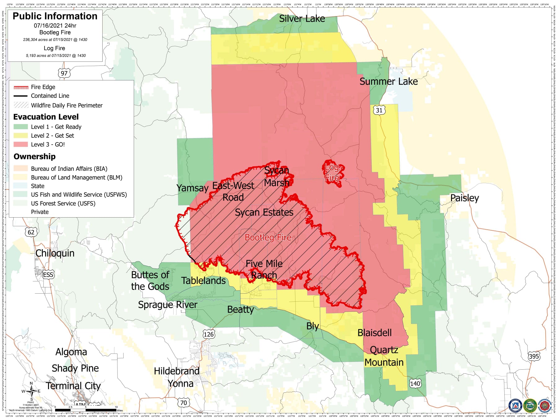
Bootleg Fire Daily Update July 16
Related Incident:
Publication Type: News
Bootleg Update July 16, 2021
Location: 28 miles northeast of Klamath Falls, OR
Size: 241,497 acres
Containment: 7%
Personnel: 1,921
(Klamath Falls, OR) – For the fourth day in a row, firefighters withdrew from leading edges of the Bootleg Fire as extreme fire conditions fueled expansive fire growth. In the late afternoon, a large pyrocumulus cloud ‘collapsed’ further spreading embers to the east of the main fire and prompting additional evacuation notices for the communities of Summer Lake and Spring Lake in Lake County. Crews worked through the night to get dozer lines around spot fires over the 34 Road to the southeastern edge of the fire. To the north, crews continued to work against very active surface fire, spotting up to a half mile ahead of the main fire, and dry southern winds.
“The Bootleg Fire perimeter is more than 200 miles long- that’s an enormous amount of line to build and hold.” said Rob Allen, Incident Commander for the Pacific Northwest Area Incident Management Team 2. “We are continuing to use every resource from dozers to air tankers to engage where it’s safe to do so especially with the hot, dry, windy conditions predicted to worsen into the weekend.”
On Thursday, firefighters made excellent progress on the southern edge of the fire as winds pushed the fire back into itself. On the fire’s western edge, firefighters continue to successfully hold the existing containment lines and are patrolling for any remaining hotspots near the fireline. In addition, several crews will continue working to protect and wrap houses towards Paisley and Summer Lake as a precaution ahead of potential fire growth toward those communities over the coming days. Additional structural firefighters will arrive today to assist the east side of the fire with structure protection.
Community Meeting: Friday July 16, 2021 at 6:30pm at www.facebook.com/BootlegFireInfo. A recorded version will also be available on our new YouTube channel.
Evacuations: Visit tinyurl.com/bootlegevac for an interactive map of current evacuation levels.
Closures: Area closures in the Fremont-Winema National Forest at inciweb.nwcg.gov/incident/7609/.
Smoke: Smoke impacts anticipated to Silver Lake, Paisley, and the greater Harney Basin. Full report at: fires.airfire.org/outlooks/southcentraloregon.
Fire Information Public Phone: 541-482-1331
Fire Information Media Phone: 971-727-7255
Inciweb: inciweb.nwcg.gov/incident/7609/
Facebook: www.facebook.com/BootlegFireInfo
Twitter: twitter.com/BootlegFireInfo
Youtube: www.youtube.com/channel/UCPLoRDU4JyfLonJpgl3gGjg
