Incident Publication
Sawlog Fire Morning Update 05 04 2025
Related Incident: Sawlog
Publication Type: News
Incident Commander: Richard Griffin (Type 3 IC)
Location: 15 miles northeast of Wisdom, MT in the Sawlog Creek drainage
Start Date: 05/01/2025
Cause: Undetermined – under investigation
Size: 1,500 acres (estimate from a helicopter mapping operation)
Resources on Site: 1 crew; 1 engine; 1 light helicopter. Additional resources enroute.
Total Personnel: 51+
CURRENT STATUS/PLANNED ACTIONS:
Conditions, including dry fuels and gusty winds, precluded firefighters from implementing any strategic firing operations yesterday. The fire activity was driven by the dry fuels and gusty winds that aligned with the topographic features of the drainage.
Firefighters experienced extreme fire behavior, especially in the timbered areas with a heavy concentration of "dead and downed" trees. The fire progressed east across Sawlog Creek, toward the fire footprint from the 2021 Alder Fire. The fire footprint from the 2021 Christensen Fire lies to the south. The crews, assisted by the helicopter, directly attacked the fire until incoming weather prompted them to disengage in the afternoon hours. Winds up to 40-50 mph associated with passing thunderstorms resulted in gusty outflow winds and downdrafts, which present dangerous conditions for firefighters. Zero precipitation fell over the fire area. Fire officials were unable to get updated acreage from an overnight infrared (IR) flight. However, mapping operations from the helicopter yesterday afternoon estimated the fire at 1,500 acres.
Today’s strategy is to secure the edges, mopping up hot spots and extinguishing areas of residual heat, especially on the west side of the river. As a precautionary measure, firefighters with engines will be providing structure protection measures for private structures on the western flank along the Big Hole River. A load of 8 smokejumpers will arrive today; given the limited access, the jumpers are the best resource to get into various inaccessible areas of the fire. They will assist in scouting opportunities for control and containment features to limit impacts to the critical values at risk (including the private land and infrastructure).
Fire investigators will continue their search to determine the fire's cause. Neither the Forest Service nor the BLM had any prescribed fires (commonly referred to as “controlled burns”) in that area.
WEATHER, FUELS, AND FIRE BEHAVIOR:
Today’s weather should be cooler, moderating fire behavior and presenting firefighters with better conditions.
The fire is burning mainly in sagebrush and Lodgepole pine timber. The north-facing slopes in the area consist of a high “dead and downed” fuel component in a mixed conifer forest, and numerous “snags” or hazard trees are present. This fuel combination poses additional hazards for firefighters and affects on-the-ground progress. Ensuring firefighter safety and protecting life and property are of the utmost importance during any incident.
The fire has exhibited moderate to extreme fire behavior, with 3 to 5-foot flame lengths in the sagebrush and isolated torching, group torching, and crown runs through the tops of the trees in the timbered areas. When winds have aligned with the orientation of drainages, fire behavior has been extreme. Fuel conditions, during this time of year (pre-green up), are extremely dry.
CLOSURES:
For public safety reasons, the Bureau of Land Management has issued a temporary closure for the Sawlog dispersed camping area, located at the Big Hole River ford site. Specific closure language can be viewed on the Sawlog Fire Inciweb page, Closures tab.
Black Swamp Fire Update 05 04 2025
Related Incident: Black Swamp Fire
Publication Type: News
NEW BERN, N.C., May 4, 2025 –The USDA Forest Service has enlisted support from North Carolina Forest Service, U.S. Fish and Wildlife, North Carolina Wildlife Resource Commission and the National Park Service to help manage the Black Swamp Fire in Croatan National Forest.
Thanks to coordinated efforts, the fire remains at 950 acres with 60 percent containment. More than 80 personnel are now assigned to the incident.
The Black Swamp Fire is burning on a southeastern pocosin- a boggy wetland full of woody shrubs and peat rich soil. Peat is a buildup of organic materials compressed over thousands of years. When it burns, it can smolder underground for long periods without visible flames, only to flare up when it reaches pockets of vegetation. Unlike most wildfires, peat fires often require extensive soaking to be fully extinguished.
Yesterday, crews did just that as they continued to flood the area saturating deep layers of peat. Firefighters closely monitored flare ups and reinforced containment lines to ensure the fire stays within control lines. Suppression efforts included helicopter water drops, sprinklers, earthen dams and pumps. Rain showers today and throughout the week are also expected to aid in drenching smoldering soil.
Closures remain in effect for Black Swamp Road, the Black Swamp OHV area, Great Lake Boating Access Area and Sheep Ridge Wilderness Area, as well as portions of Great Lake Road, Seaborn Road and Holston Hunter Road.
Smoke from the fire can cause limited visibility and may impact local air quality. Please drive slowly and use caution on roads where smoke may be settling. Check for air quality alerts at https://airquality.climate.ncsu.edu/ or https://fire.airnow.gov.
For the latest wildfire updates, follow the National Forests in North Carolina on Facebook at U.S. Forest Service - National Forests in North Carolina or visit https://www.fs.usda.gov/r08/northcarolina
Sawlog Fire Evening Update 05 03 2025
Related Incident: Sawlog
Publication Type: News
Conditions, including dry fuels and gusty winds, precluded firefighters from implementing any strategic firing operations today.
Firefighters experienced extreme fire behavior, especially in the timbered areas with a heavy concentration of "dead and downed" trees. The fire progressed east across Sawlog Creek, toward the fire footprint from the 2021 Alder Fire. The fire footprint from the 2021 Christensen Fire lies to the south.
The crews, assisted by the helicopter, attacked the fire until incoming weather prompted them to disengage late this afternoon. Winds up to 40-50 mph associated with passing thunderstorms resulted in gusty outflow winds and downdrafts, which present dangerous conditions for firefighters. Zero precipitation fell over the fire area.
Fire officials characterized the fire behavior as "very uncommon" for this time of year. Given these extremely dry fuel conditions, the potential for fire growth is high. Today's acreage growth could not be determined exactly, as firefighters were unable to see the main fire. An infrared mapping flight has been ordered for the overnight hours.
‼ For public safety reasons, the Bureau of Land Management has issued a temporary closure for the Sawlog dispersed camping area, located at the Big Hole River ford site.
Fire investigators will continue their search to determine the fire's cause.
Sawlog Fire Update 05 03 2025
Related Incident: Sawlog
Publication Type: News
Incident Commander: Alex Graham (Type 4 IC)
Location: 15 miles northeast of Wisdom, MT in the Sawlog Creek drainage
Start Date: 05/01/2025
Cause: Undetermined – under investigation
Size: 383 acres (overnight infrared flight on May 2nd)
Resources on Site: 1 crew; 1 engine; 1 light helicopter
Total Personnel: 51
CURRENT STATUS/PLANNED ACTIONS:
A 20-person crew will join the 31 firefighters on site today. Utilizing the helicopter for water bucket drops and strategic firing operations, today's efforts will concentrate on the area along Sawlog Creek Road extending north to the Big Hole River (eastern edge of the fire) and the area along Toomey Creek north to the Big Hole River (western edge of the fire).
Strategic firing operations are utilized so crews can burn the fuels between the uncontrolled/active fire edge and the control line along the roads and natural barriers. This fire suppression tactic is an effective method of reducing the available fuels ahead of an active fire edge, while decreasing the potential for negative impacts to values and resource damage that result when high-severity fire occurs on timbered slopes.
The fire footprint from the Christensen Fire of 2021 lies to the south.
There is a heavy dead and downed fuel component on the north-facing ridges in the fire area. Fire behavior yesterday consisted of up to 5-foot flame lengths in the sagebrush and crown runs in the timber.
Fire investigators will continue their search to determine the fire's cause.
The fire was mapped at approximately 475 acres late yesterday afternoon, burning both Forest Service and BLM lands. An overnight infrared flight mapped the fire area at 383 acres.
WEATHER AND FIRE BEHAVIOR:
The fire is burning mainly in sagebrush and Lodgepole pine timber. The north-facing slopes in the area consist of a high down and down fuel component. The fire exhibited moderate fire behavior, with 3 to 5-foot flame lengths in the sagebrush and isolated torching, group torching, and crown runs through the tops of the trees in the timbered areas.
Weather conditions will be similar to yesterday, with temperatures approaching the upper 70s and relative humidity in the mid-teens to 20%. Winds will be from the southwest, reaching 10 mph in the afternoon hours.
Black Swamp Fire Update 05 03 2025
Related Incident: Black Swamp Fire
Publication Type: News
NEW BERN, N.C., May 3, 2025 – The Black Swamp Fire remains at 950 acres and 60% contained as suppression efforts continue in the Croatan National Forest.
Over 80 personnel from the USDA Forest Service, North Carolina Forest Service, U.S. Fish and Wildlife, North Carolina Wildlife Resource Commission and the National Park Service are supporting response operations, while southerly winds push the fire.
Heavy equipment groups are continuing to improve containment on No Name and Moccasin Lane Road. Engines are making good progress soaking the flammable organic materials around the perimeter of the fire with the sprinkler system, especially on the north and east lines. Earthen dams will be installed to aid in pumping more water to areas surrounding the fire. Today will be a continuation of yesterday's efforts in improving contingency lines, sprinkler operations, and moving larger quantities of water closer to the fire. 195,000 gallons of water have been dropped on the fire by helicopters, extinguishing pockets of flames.
Closures remain in effect for Black Swamp Road, the Black Swamp OHV area, Great Lake Boating Access Area and Sheep Ridge Wilderness Area, as well as portions of Great Lake Road, Seaborn Road and Holston Hunter Road.
Smoke from the fire can cause limited visibility and may impact local air quality. Please drive slowly and use caution on roads where smoke may be settling. Check for air quality alerts at https://airquality.climate.ncsu.edu/ or https://fire.airnow.gov.
For the latest wildfire updates, follow the National Forests in North Carolina on Facebook at U.S. Forest Service - National Forests in North Carolina or visit https://www.fs.usda.gov/r08/northcarolina.
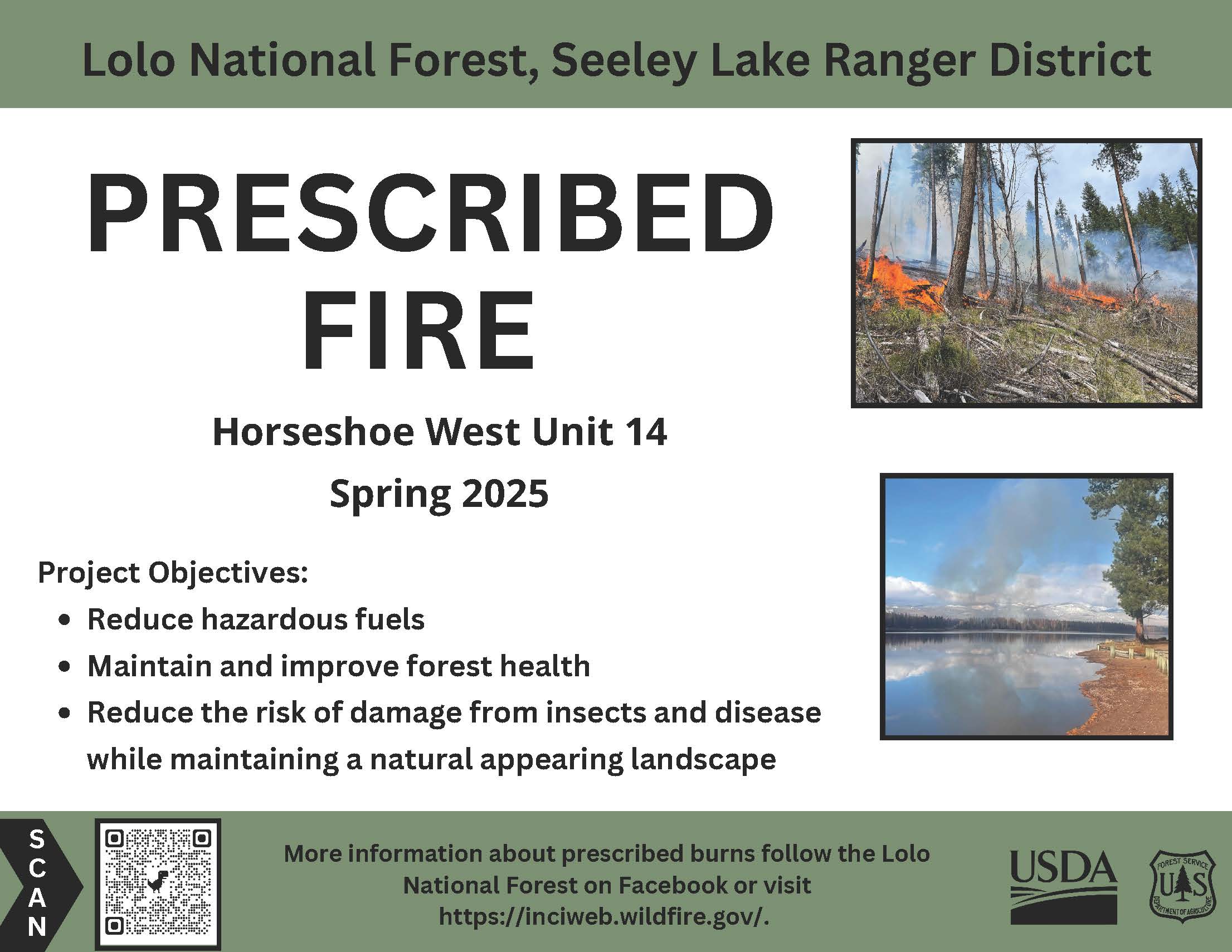
May 3 Prescribed Fire Operations 05 02 2025
Related Incident: Lolo National Forest Prescribed Fire Operations
Publication Type: Announcement
Seeley Lake Ranger District: Firefighters will burn up to 38 acres in the Horseshoe West project area, 4 miles South of Seeley Lake. Minimal smoke impacts are anticipated; however, smoke may be visible from Highway 83 in the Seeley Lake area.
All prescribed burns will be implemented in compliance with Montana air quality standards and coordinated with the Montana Department of Environmental Quality to reduce the impact of smoke on neighbors, cooperators and surrounding communities. Smoke is expected to be a short-duration event and may settle in valley bottoms and drainages overnight and will dissipate within a few days.

Stronghold Fire Update for Friday05 02 2025
Related Incident: Stronghold Fire
Publication Type: News
Summary: Favorable weather conditions overnight, including cooler temperatures and higher relative humidity levels, continue to play a role in minimal fire activity. No additional growth has been reported on the fire over the last few days. The fire is 2,138 acres and 62% contained. This morning, the Cochise County Sheriff’s Office lifted the last remaining SET notifications for the areas south of Ironwood Road and west of Cochise Stronghold Road. All residents are in READY status.
For today’s operational plan, crews will finish up work along the west end of the fire by securing any remaining uncontained line and checking for any potential threats to the line. The north and east sides of the fire are secured, but engines continue patrolling and monitoring that side, serving as a presence within the communities. An Unmanned Aircraft System (UAS) has been supporting the fire by flying infrared (IR) and reconnaissance missions in areas with steep and rugged terrain. The IR flights revealed some hotspots of heavy fuels that continue to smolder, located deep within the fire’s interior. Resources will work on mopping those up today. Firefighter and public safety remain paramount through the duration of the incident as resources work toward full suppression and protection of all values at risk.
Some Stronghold firefighting resources have been designated as Initial Attack for new starts that may occur in the area, within the incident’s designated Temporary Flight Restriction (TFR), as well as outside the TFR as requested by the state and/or Coronado National Forest. Over the next few days, operations will be releasing some resources in order to right size the incident and match the fire’s needs.
Evacuations and Closures: Out of public safety, the Coronado National Forest Douglas Ranger District has implemented a Temporary Occupancy and Use Area Order due to the Stronghold Fire: https://www.fs.usda.gov/r03/coronado/alerts/stronghold-fire
Weather: Hot, windy, and dry conditions remain a concern for fire operations. Weather pattern shifts this weekend could bring critical fire weather during a wind event.
Safety: Due to aircraft use, a TFR (Temporary Flight Restriction) is in place over the fire. Firefighting aircraft and drones are a dangerous combination. Drones in the area could lead to accidents or slow down wildfire suppression operations. If you fly…we can’t.
Black Swamp Fire Update 05 02 2025
Related Incident: Black Swamp Fire
Publication Type: News
NEW BERN, N.C., May 2, 2025 – The Black Swamp Fire remains at 950 acres and 60% contained as suppression efforts continue in the Croatan National Forest.
Personnel from five agencies—USDA Forest Service, North Carolina Forest Service, U.S. Fish and Wildlife, North Carolina Wildlife Resource Commission and the National Park Service—are working together on the incident, with more than 80 responders assigned.
Infrared mapping tools used by helicopter pilots show underground heat within containment lines. Several internal pockets of flames flared up and were quickly extinguished by helicopter bucket drops. Firefighters are flooding the smoldering organic material using a system of canals, pumps and sprinklers. Crews are exercising extra caution as they carefully monitor and mop up to ensure that flames do not jump containment lines.
Firefighters responded to another fire south of Havelock, North Carolina, off Highway 70, on Forest Service land. The fire spread to the western side of the train tracks, but thanks to quick response actions, initial attack was able to contain the Train Tracks Fire at 2 acres and will work to completely extinguish the fire while suppression efforts continue on the Black Swamp Fire.
Closures remain in effect for Black Swamp Road, the Black Swamp OHV area, Great Lake Boating Access Area and Sheep Ridge Wilderness Area, as well as portions of Great Lake Road, Seaborn Road and Holston Hunter Road.
Smoke from the fire can cause limited visibility and may impact local air quality. Please drive slowly and use caution on roads where smoke may be settling. Check for air quality alerts at https://airquality.climate.ncsu.edu/ or https://fire.airnow.gov.
For the latest wildfire updates, follow the National Forests in North Carolina on Facebook at U.S. Forest Service - National Forests in North Carolina or visit https://www.fs.usda.gov/r08/northcarolina.
Stronghold Fire Update for Thursday05 01 2025
Related Incident: Stronghold Fire
Publication Type: News
Summary: Despite weather and topography challenges, crews continue to make good progress on the fire. With an increase in containment on Wednesday, today, the Cochise County Sheriff’s Office reduced the GO status for some residents impacted by the fire. This morning, the Sheriff’s Office lifted the GO status and returned residents to SET in the areas south of Ironwood Road and west of Cochise Stronghold Road. All residents in SET have returned to READY.
For the second night in a row, the Stronghold Fire stayed within its fire footprint. Resources on a night shift reported very minimal fire activity. The night shift maintained a presence in nearby communities by patrolling and monitoring the fire’s edge. An infrared flight conducted on Wednesday confirmed the acres at 2,138. The fire is now 54% contained.
Aircraft continues to support the Stronghold Fire and on Wednesday it was utilized as logistical support to sling water, food, and other supplies to crews working in the inaccessible terrain. Due to the aircraft usage, a Temporary Flight Restriction (TFR) was put into effect within the first few hours of the fire’s start. Over the last few days, two incursions within the TFR have been reported to Air Operations. Any incursion in the airspace from aircraft or Unmanned Aircraft Systems (UAS) pose a serious threat to air and ground resources. Often times, if an incursion occurs, suppression operations can come to a halt as aircraft supporting the incident must be grounded and ground resources pulled off the fireline.
For today’s operations, resources assigned to the north and east sides of the fire will continue to patrol and monitor within those areas, checking for any interior smokes or potential threats to the line in anticipation of this weekend’s forecast critical fire weather. Along the east flank, hand crews previously completed and secured the hand line from Ironwood and Cochise Stronghold Roads south to Highland Road. Along the southwest side, fire activity has decreased, but it remains hung up within the Dragoons in rocky and inaccessible terrain. The southeast side within Grapevine Canyon consists of similar terrain. Hotshot and hand crews are working in those areas and will finish putting line in along the ridgelines and where it is safe to do so. They will also monitor and respond to any hotspots or rollouts. Today, resources will expand the contingency line on the south side and tie it into Middlemarch Road. Firefighters are using direct, indirect, and point protection tactics to fully suppress the fire. Engine resources remain engaged, patrolling and monitoring the fire’s perimeter, and extinguishing any hot spots along the edge. The Stronghold Fire is a full suppression fire with incident objectives including firefighter and public safety, structure and infrastructure protection, and watershed and wildlife protection. Some Stronghold Fire resources will be designated as Initial Attack to any new starts that may occur in the area over the next few days.
Out of public safety, the Coronado National Forest Douglas Ranger District has implemented a Temporary Occupancy and Use Area Order due to the Stronghold Fire: https://www.fs.usda.gov/r03/coronado/alerts/stronghold-fire
Evacuations and Closures: SET: south of Ironwood Road and West of Cochise Stronghold Road. For additional updates on evacuations, check with the Cochise County Sheriff’s Office.
Weather: Hot, windy, and dry conditions remain a concern for fire operations. Weather pattern shifts this weekend could bring critical fire weather during a wind event.
Safety: Due to aircraft use, a TFR (Temporary Flight Restriction) is in place over the fire. Firefighting aircraft and drones are a dangerous combination. Drones in the area could lead to accidents or slow down wildfire suppression operations. If you fly…we can’t.