
The Sawlog Fire was reported on the afternoon of May 1st. Forest Service fire officials from the Beaverhead-Deerlodge National Forest responded to the area, located west of Wise River and northeast of Wisdom in the Sawlog Creek drainage. The fire was initially estimated at 50-70 acres, burning on the south side of the Big Hole River. Immediate access to the fire area was somewhat limited, given the time of year with the snow melt and high water conditions in the river. Upon arriving at the fire's location, firefighters observed the fire burning actively in sagebrush and Lodgepole pine timber. A large "dead and downed" component of fuels exists on the north-facing slopes in the area.
The fire is located between the Sawlog Creek and Toomey Creek drainages, on the south side of the Big Hole River. Updated mapping confirms the fire is burning Forest Service and Bureau of Land Management lands. The fire footprint from the 2021 Christensen Fire is located to the south, and the fire footprint from the 2021 Alder Fire is located to the east.
Fire investigators are working to determine the exact cause of the fire. Neither the Forest Service nor the BLM had any prescribed fires (commonly referred to as “controlled burns”) in that area.
| Current as of | Sun, 05/04/2025 - 21:31 |
|---|---|
| Incident Type | Wildfire |
| Cause | Undetermined |
| Date of Origin | |
| Incident Time Zone | Mountain Standard Time |
| Location | 15 miles northeast of Wisdom, MT |
| Incident Commander | Richard Griffin, ICT3 Kyle Errecart, ICT3 (T) USDA Forest Service |
| Coordinates |
45° 49' 41'' Latitude
-113° 15' 10
'' Longitude
|
| Total Personnel: | 65 |
|---|---|
| Size | 1,500 Acres |
| Percent of Perimeter Contained | 5% |
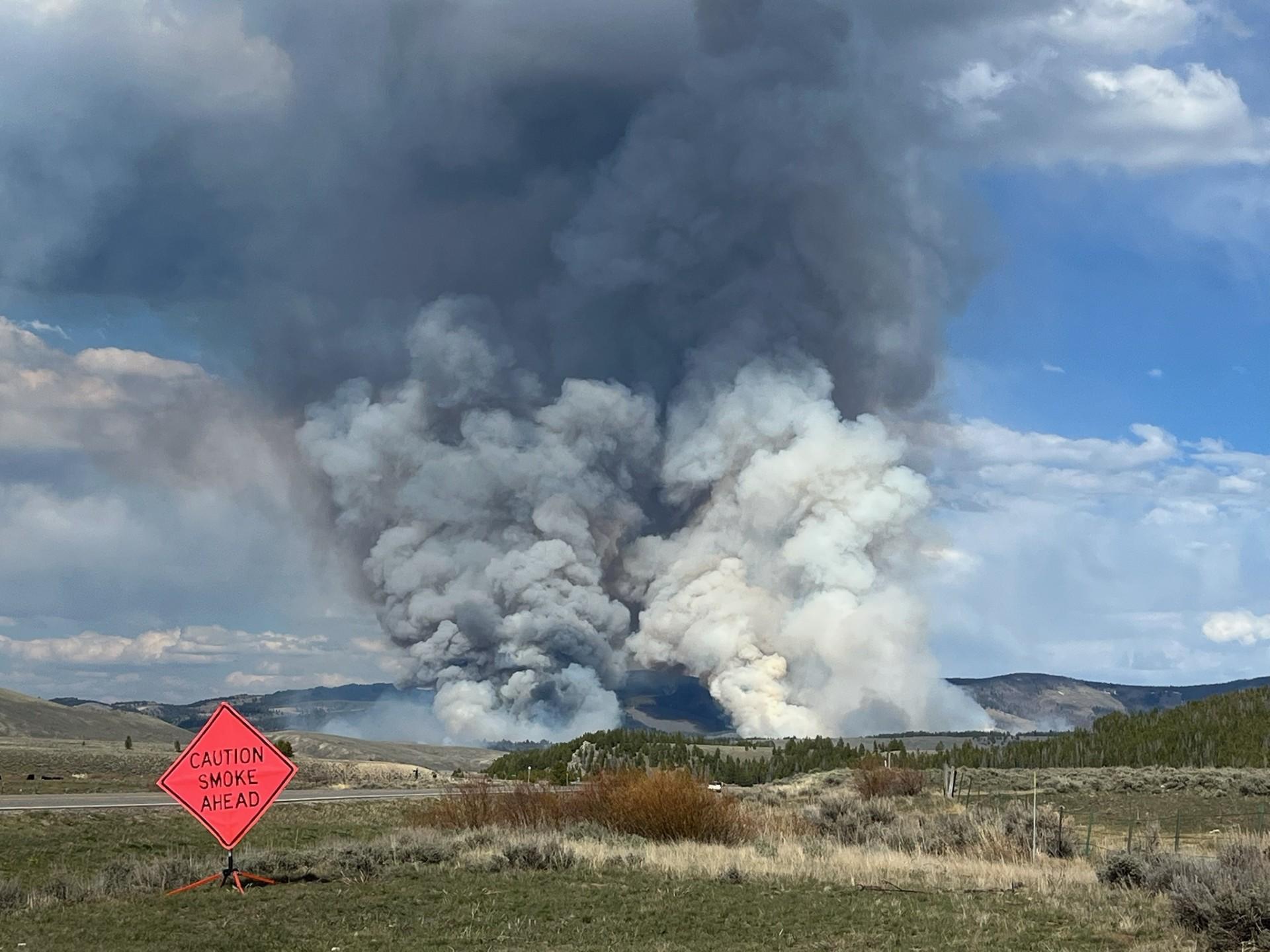
| Fuels Involved | Timber, sagebrush, and short grass. The fire is burning mainly in sagebrush and Lodgepole pine timber. The north-facing slopes in the area consist of a high “dead and downed” fuel component in a mixed conifer forest, and numerous “snags” or hazard trees are present. This fuel combination poses additional hazards for firefighters and affects on-the-ground progress. Ensuring firefighter safety and protecting life and property are of the utmost importance during any incident. The fire has exhibited moderate to extreme fire behavior, with 3 to 5-foot flame lengths in the sagebrush and isolated torching, group torching, and crown runs through the tops of the trees in the timbered areas. When winds have aligned with the orientation of drainages, fire behavior has been extreme. Fuel conditions, during this time of year (pre-green up), are extremely dry. |
| Significant Events | Conditions, including dry fuels and gusty winds, precluded firefighters from implementing any strategic firing operations yesterday. The fire activity was driven by the dry fuels and gusty winds that aligned with the topographic features of the drainage. Engines from the Grasshopper VFD patrolled near the private structures throughout the night. Today, smokejumpers and other firefighters secured line from the Toomey Creek Road to the river on the south flank. A helicopter assisted the ground crews with water bucket drops; two helicopters were forced to relocate to Butte due to the weather conditions. |
| Planned Actions |
Today’s strategy was to secure the edges, mopping up hot spots and extinguishing areas of residual heat, especially on the west side of the river. As a precautionary measure, firefighters with engines will be providing structure protection measures for private structures on the western flank along the Big Hole River. A load of 8 smokejumpers arrived today; given the limited access, the jumpers are the best resource to get into various inaccessible areas of the fire. They assisted in scouting opportunities for control and containment features to limit impacts to the critical values at risk (including the private land and infrastructure).
|
|---|---|
| Projected Incident Activity |
Fire officials characterized the fire behavior as "very uncommon" for this time of year. Given these extremely dry fuel conditions, the potential for fire growth is high. A warming and drying trend should arrive by mid-week, as a ridge builds over the fire area. |
| Remarks |
Working in cooperation with local and interagency partners, fire managers have identified and prioritized values at risk of the Sawlog Fire. Their planning is strategic in nature, focusing available resources and current efforts on protecting critical values at risk (CVAR) while decreasing the potential for negative impacts and resource damage.
|
| Weather Concerns | Temperatures were much cooler today. The fire area received precipitation in the form of a light drizzle for about an hour. Gusty winds associated with passing thunderstorms produce outflow winds and downdrafts, causing dangerous conditions for firefighters.
|
|---|