
Incident Publication
Black Swamp Fire Daily Update 05 07 2025
Related Incident: Black Swamp Fire
Publication Type: News
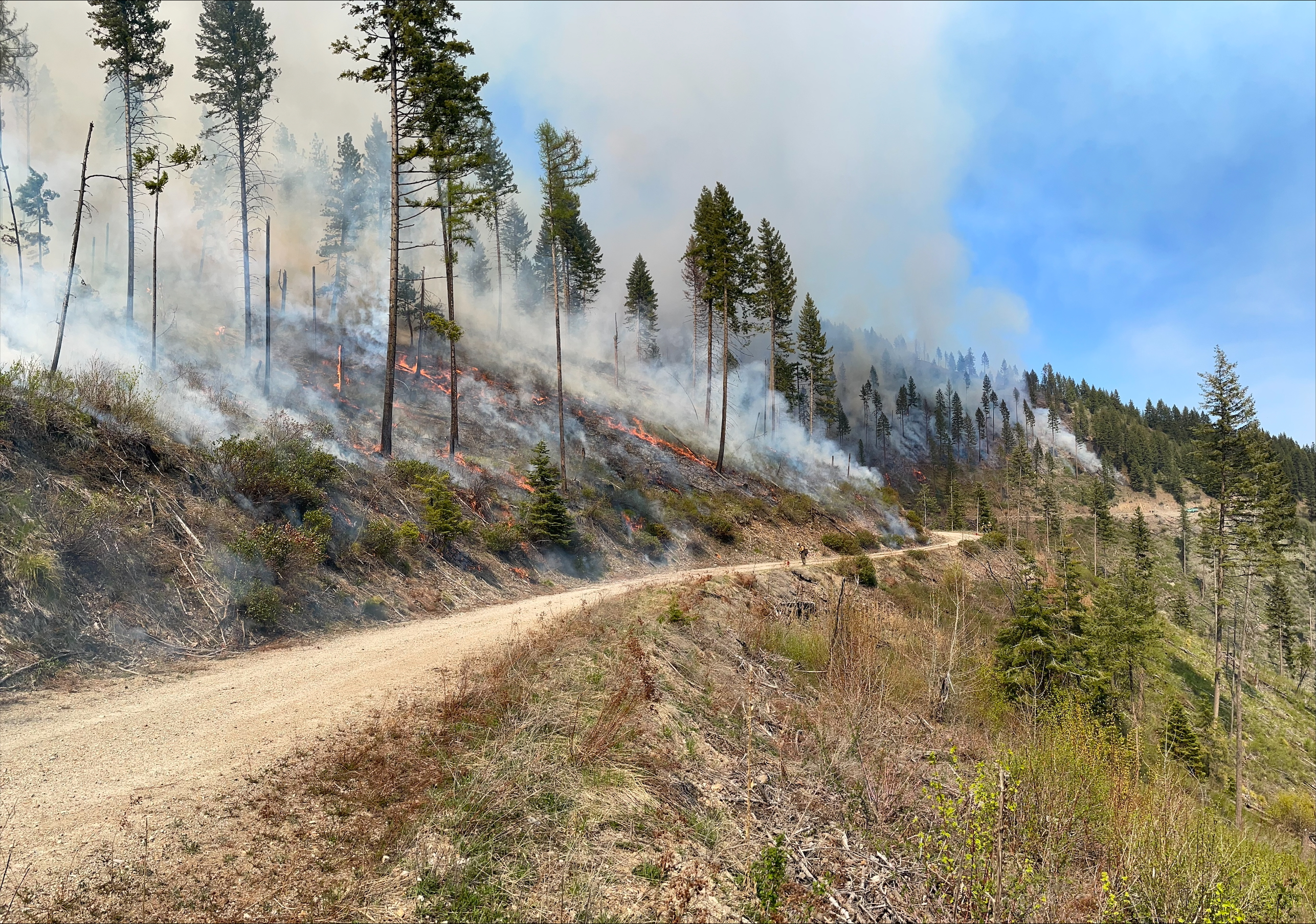
NEW BERN, N.C., May 7, 2025 – The USDA Forest Service and its partners report steady progress on the Black Swamp Fire in Croatan National Forest. The fire is holding at 950 acres and is 60% contained. Partnering agencies including North Carolina Forest Service, U.S. Fish and Wildlife, North Carolina Wildlife Resource Commission and the National Park Service to help manage the fire. 103 personnel are actively working on the fire.
Crews continued mop up on Moccasin Lane and Black Swamp Road, and sprinkler operations around the perimeter of the fire. There are currently three pumps installed to carry water from Great Lake closer to the fire to aid in suppression. More pumps will be added within the next few days. Firefighting personnel will keep repairing Moccasin Lane which will allow crews to move easily through the soft ground with less impact.
Closures remain in effect for Black Swamp Road, the Black Swamp OHV area, Great Lake Boating Access Area and Sheep Ridge Wilderness Area, as well as portions of Great Lake Road, Seaborn Road and Holston Hunter Road. Please drive cautiously on Catfish Lake Road due to increased emergency vehicle traffic.
Smoke from the fire can cause limited visibility and may impact local air quality. Please drive slowly and use caution on roads where smoke may be settling. Check for air quality alerts at https://airquality.climate.ncsu.edu/ or https://fire.airnow.gov.
For the latest wildfire updates, follow the National Forests in North Carolina on Facebook at U.S. Forest Service - National Forests in North Carolina or visit https://www.fs.usda.gov/r08/northcarolina
Sawlog Fire Morning Update 05 07 2025
Related Incident: Sawlog
Publication Type: News
Incident Commander: Richard Griffin (Type 3 IC) and Kyle Errecart (Type 3 IC Trainee)
Location: 15 miles northeast of Wisdom, MT in the Sawlog Creek drainage
Start Date: 05/01/2025
Cause: Undetermined – under investigation
Size: 1,412 acres (change due to accurate mapping)
Resources Assigned: 3 crews; 3 engines; 1 helicopter; 1 water tender; 1 skidgen
Total Personnel: 134
Containment: 10%
CURRENT STATUS/PLANNED ACTIONS:
Cooler temperatures and higher relative humidity levels continued to play a role in minimal fire activity yesterday. Fire behavior was limited to creeping and smoldering. The fire area received 0.10 to 0.30 inches of precipitation over that last 48 hours. Large, heavy fuels continue to smolder, despite the precipitation. Fire behavior is expected to pick up as warmer and drier weather is forecasted over the next few days.
On the western edge, crews are continuing with structure assessments working north along the Highway 43 corridor. A boat will be used to support firefighters in gaining access to the fire across the Big Hole River over the high-water conditions.
On the northern flank and working to the south, the smokejumpers identified helispot locations; they progressed along the north, working along the eastern flank scouting potential control lines along this, looking for opportunities to go direct in the Tucker Creek area. A large skidgen has arrived and will support the smokejumpers with water missions.
On the southern edge, firefighters are progressing east from the Big Hole River along Toomey Creek with mop up operations. Two Type 1 hotshot crews are prepping line towards the 2021 Alder Creek Fire footprint.
The helicopters were utilized for cargo missions to support the firefighters. An Unmanned Aircraft System (UAS) has been supporting the fire by flying infrared (IR) and reconnaissance operations that are inaccessible by foot and thick with hazard trees or “snags.” Scattered heat along the entire fire perimeter was found yesterday by flying infrared.
An Incident Command Post has been established at Wisdom Airport.
The fire remains under investigation. Neither the Forest Service nor the BLM had any prescribed fires (commonly referred to as “controlled burns”) in that area.
WEATHER, FUELS, AND FIRE BEHAVIOR:
Temperatures forecasted to return to high 70's and low 80's through the rest of the week and into the weekend. A mostly dry cold front will move across the fire area Thursday morning bringing gusty westerly winds.
The fire is burning mainly in sagebrush and Lodgepole pine timber. The north-facing slopes in the area consist of a high “dead and downed” fuel component in a mixed conifer forest, and numerous “snags” or hazard trees are present. This fuel combination poses additional hazards for firefighters and affects on-the-ground progress.
Ensuring firefighter safety and protecting life and property are of the utmost importance during any incident.
Prior to the cold front, the fire exhibited moderate to extreme fire behavior, with 3 to 5-foot flame lengths in the sagebrush and isolated torching, group torching, and crown runs through the tops of the trees in the timbered areas. When winds have aligned with the orientation of drainages, fire behavior has been extreme. Fuel conditions, during this time of year (pre-green up), are extremely dry.
The fire footprint from the 2021 Alder Fire is located to the east, and the fire footprint from the 2021 Christensen Fire lies to the south.
CLOSURES:
For public safety reasons, the Bureau of Land Management has issued a temporary closure for the Sawlog dispersed camping area, located at the Big Hole River ford site. Specific closure language can be viewed on the Sawlog Fire Inciweb page, Closures tab.
A Temporary Flight Restriction (TFR) has been implemented over the fire area. This allows for firefighting aircraft to safely work over the fire area. Firefighting aircraft and drones are a dangerous combination. Drones in the area could lead to accidents or slow down wildfire suppression operations. If you fly…we can’t.
Helispot Built to Support Fireline Supply Operations in Remote Terrain 05 07 2025
Related Incident:
Publication Type: News
For Immediate Release:
Notification for Public Health and Safety
Helispot Built to Support Fireline Supply Operations in Remote Terrain
Press Release – Wednesday, May 7, 2025
Acres: 901
Start Date: Sunday, May 4, 2025
Location: 38 miles east of Glenwood, NM
Personnel: 168
Containment: 5%
Cause: Lightning
Summary: Two hotshot crews used direct line construction tactics on the fire edge and completed construction of a helispot yesterday. The purpose of creating helicopter access is to support the aerial delivery of supplies. The helispot will be used to fly in gear, food, water and other supplies, ensuring firefighters have the resources needed to safely and effectively continue suppression operations in this remote area.
Today, five hotshot crews assigned to the incident - Gila, Idaho City, Blue Ridge, Flagstaff, and Smokey Bear— will continue with direct fireline construction. To maximize work time and maintain direct engagement with the fire, four of the five crews will camp near the fireline rather than returning to the Incident Command Post (ICP) each day.
Structure protection resources remain active around Snow Lake and Willow Creek, where a group of six engines has completed indirect line and chipping operations. These engines will continue to assess structures in Snow Lake area while building a contingency plan should the direct suppression strategy not be successful.
With recent thunderstorms moving through the area and very dry vegetation, two engines and one hotshot crew will be ready to assist with initial attack should a new fire be detected nearby. Current resources assigned to the fire include five hotshot crews, one type one helicopter, two type 3 helicopters, six engines, and miscellaneous overhead assigned.
CDT Hikers: The public is asked to avoid the fire area for their safety. For more information on trail access, including alternate routes, contact info@cdtcoalition.org.
Temporary Closures: The Snow Lake area, including Dipping Vat Campground, Snow Lake Boat Launch, and Snow Lake Trailhead are temporarily closed for public safety.
Safety: A Temporary Flight Restriction (TFR) is in place over the fire. Drones pose a serious risk to firefighting aircraft. If you fly, we can’t!
Smoke: Smoke may be visible from Mogollon, Willow Creek, Reserve, CP Anderson and Snow Lake. For current smoke conditions, visit the interactive smoke map at fire.airnow.gov.
Fire Restrictions: Stage 2 Fire Restrictions are in effect on the Gila National Forest. Learn more at www.fs.usda.gov/r03/gila/alerts.
For more information:
Public Information Officer: Email2025.iron@firenet.gov or 575-323- 8956, 8am - 8pm
Incident Information: https://inciweb.wildfire.gov/incident-information/nmgnf-iron-fire
Facebook: www.facebook.com/GilaNForest
###
El Equipo para gestin de Incidentes de Tipo 3 asume el mando del Incendio Iron 05 06 2025
Related Incident:
Publication Type: News
Información de última hora:
Notificación para la Salud y Seguridad Publica
El Equipo para gestión de Incidentes de Tipo 3 asume el mando del Incendio Iron
Comunicado de Prensa – martes, 6 de mayo del 2025
Acres: 901
Fecha de inicio: Domingo, 4 de mayo, 2025
Ubicación: 38 millas al Este de Glenwood, NM
Personal: 156
Contención: 0%
Causa: Bajo Investigación
Resumen: A las 6:00 a.m. del día de hoy, el comandante de Incidentes Marcus Cornwell y el Equipo de Manejo de Incidentes (IMT) Tipo 3 de Gila Las Cruces asumieron el mando del Incendio Iron. El incendio fue reportado por primera vez el 4 de mayo y se encuentra ardiendo en la hierba, madera y vegetación seca internándose en la cicatriz que dejo el Incendio Complejo de 2012, Whitewater Baldy. El domingo, 4 de mayo, las condiciones climáticas cálidas y ventosas causaron un rápido crecimiento del fuego a 901 acres. Sin embargo, el clima más fresco y el aumento de la humedad el lunes ayudó a moderar la actividad del fuego.
Una vez detectado el incendio, se utilizó un helicóptero para realizar un reconocimiento aéreo e irrigar el área frenando la propagación del incendio. Debido a la presencia continua del viento, se solicitó el apoyo de un avión cisterna grande (LAT) y otro de mayo tamaño (VLAT), los cuales lanzaron retardante para ayudar a contener el incendio mientras los equipos en tierra se dedicaron a evaluar rutas de acceso seguras a través de un terreno escarpado y abrupto.
El domingo por la tarde y el lunes por la mañana recursos adicionales comenzaron a arribar a la zona. Los bomberos están mejorando las líneas de contención indirecta construidas previamente durante las respuestas a incendios forestales anteriores, incluidas las zonas de Snow Lake al sistema de Willow Creek Road, detrás de la Subdivisión de Willow Creek, y a lo largo de la carretera 159 de Nuevo México. Las cuadrillas también están llevando a cabo operaciones de astillado para eliminar ramas y escombros remanentes después de darse las mejoras de la línea.
Aunque los niveles de humedad reciente han ayudado en el trabajo para la extinción del incendio, no ha sido suficiente para desactivarlo. Una vez que pase el sistema natural de tormentas, el material de combustión seco en toda la zona puede contribuir a aumentar el comportamiento del fuego.
Evacuaciones: SALGA - Nivel de Evacuación 3 se encuentra en efecto para el área de Snow Lake, incluyendo el campamento Dipping Vat, Snow Lake Boat Launch, y el sendero de Snow Lake.
Seguridad: Se encuentra vigente la restricción temporal de vuelo (TFR) sobre la zona del incendio. Los drones representan un grave riesgo para los aviones combatiendo el fuego. ¡Si Usted vuela, Nosotros no podemos!
Presencia del Humo: El humo puede ser visible desde Mogollon, Willow Creek, Reserve, CP Anderson y Snow Lake. Para información acerca de las condiciones actuales de humo, visite el mapa interactivo de humo en fire.airnow.gov fire.airnow.gov.
Restricciones de fuego: Se encuentra vigente la Etapa 2 de Restricciones de fuego para el Bosque Nacional de Gila. Para más información visite www.fs.usda.gov/r03/gila/alerts.
Cierres: No hay cierres en este momento.
Para más información:
Oficial de Información Pública: 2025.iron@firenet.gov, 575-323-8956, 8am - 8pm
Información del incidente: https://inciweb.wildfire.gov/incident-information/nmgnf-iron-fire
Facebook: www.facebook.com/GilaNForest
PREPÁRESE, LISTOS, SALGA: https://ein.az.gov/ready-set-go
Type 3 Incident Management Team Assumes Command of Iron Fire 05 06 2025
Related Incident:
Publication Type: News
For Immediate Release:
Notification for Public Health and Safety
Type 3 Incident Management Team Assumes Command of Iron Fire
Press Release – Tuesday, May 6, 2025
Acres: 901 Start Date: Sunday, May 4, 2025
Location: 38 miles east of Glenwood, NM Personnel: 156
Containment: 0% Cause: Under Investigation
Summary: At 6:00 a.m. today, Incident Commander Marcus Cornwell and the Gila Las Cruces Type 3 Incident Management Team (IMT) assumed command of the Iron Fire. The fire was first reported on May 4 and is burning in grass, timber, and dead vegetation within the 2012 Whitewater Baldy Complex Fire burn scar. On Sunday, May 4, warm and windy conditions caused rapid fire growth to 901 acres. However, cooler weather and increased moisture on Monday helped moderate fire activity.
Upon detection, a helicopter was used for aerial reconnaissance and water bucket drops to slow the fire’s spread. Due to continued winds, support was requested from a Large Air Tanker (LAT) and a Very Large Air Tanker (VLAT), both of which dropped retardant to help contain the fire while ground crews assessed safe access routes through steep and rugged terrain.
Additional resources began arriving Sunday afternoon and into Monday morning. Firefighters are improving indirect containment lines previously constructed during earlier wildfire responses, including areas from Snow Lake to the Willow Creek Road system, behind the Willow Creek Subdivision, and along New Mexico Highway 159. Crews are also conducting chipping operations to remove slash (branches and debris) left from line improvements.
Although recent moisture has aided suppression efforts, the fire remains active. Once the storm system passes, dry fuels throughout the area may contribute to increased fire behavior.
Evacuations: GO – Level 3 evacuation status is in effect for the Snow Lake area, including Dipping Vat Campground, Snow Lake Boat Launch, and Snow Lake Trailhead.
Safety: A Temporary Flight Restriction (TFR) is in place over the fire. Drones pose a serious risk to firefighting aircraft. If you fly, we can’t!
Smoke: Smoke may be visible from Mogollon, Willow Creek, Reserve, CP Anderson and Snow Lake. For current smoke conditions, visit the interactive smoke map at fire.airnow.gov.
Fire Restrictions: Stage 2 Fire Restrictions are in effect on the Gila National Forest. Learn more at www.fs.usda.gov/r03/gila/alerts.
Closures: There are no closures at this time.
For more information:
Public Information Officer: Email2025.iron@firenet.gov or 575-323- 8956, 8am - 8pm
Incident Information: https://inciweb.wildfire.gov/incident-information/nmgnf-iron-fire
Facebook: www.facebook.com/GilaNForest
Ready, Set, Go: https://ein.az.gov/ready-set-go
Sawlog Fire Morning Update 05 06 2025
Related Incident: Sawlog
Publication Type: News
Incident Commander: Richard Griffin (Type 3 IC) and Kyle Errecart (Type 3 IC Trainee)
Location: 15 miles northeast of Wisdom, MT in the Sawlog Creek drainage
Start Date: 05/01/2025
Cause: Undetermined – under investigation
Size: 1,500 acres (estimate from a helicopter mapping operation)
Resources Assigned: 3 crews; 3 engines; 1 helicopter
Total Personnel: 121
Containment: 10%
CURRENT STATUS/PLANNED ACTIONS:
With temperatures in the upper 30s to low 40s yesterday, the Sawlog fire behavior was limited to creeping and smoldering. The fire area received significant precipitation, with snow at higher elevations. The large, heavy fuels continue to smolder despite the precipitation; overall fire behavior is expected to pick up as warmer and drier weather returns mid-week.
On the western edge, engines continued to patrol along Highway 43, providing structure assessments, a structure protection plan, and a river access plan. Access to the fire over the high-water conditions in the Big Hole River will improve with the arrival of a boat to ferry firefighters across.
On the northern flank and working to the east, the smokejumpers scouted for opportunities to construct helispots and potential control lines; they have progressed significantly with “mop-up” of hot spots along this flank of the fire. They will continue to secure this section, working to completely extinguish all heat 66 feet interior to the fire’s edge before calling this section contained.
The helicopters were unable to fly yesterday due to the weather but will look to reposition to the helibase in Wise River today. A UAS (unmanned aircraft system) arrived and will be utilized for infrared mapping and other data gathering operations in areas inaccessible by foot and thick with hazard trees or “snags.”
Though helpful with moderating fire behavior, the precipitation will likely complicate access to the fire area. Muddy road conditions, requiring UTVs for access, are not conducive to travel by standard vehicles. Firefighters will be conscious of limiting impacts to roadbeds and natural resources.
Additional resources are arriving. An Incident Command Post will be established at Wisdom Airport.
Conditions, including dry fuels and gusty winds, precluded firefighters from implementing any strategic firing operations as a firefighting tactic. The fire activity, including most of the acreage gain during the burning period on May 3rd, was driven by the dry fuels and gusty winds that aligned with the topographic features of the drainage.
Fire investigators will continue their search to determine the fire's cause. Neither the Forest Service nor the BLM had any prescribed fires (commonly referred to as “controlled burns”) in that area.
WEATHER, FUELS, AND FIRE BEHAVIOR:
Today’s weather will be slightly warmer, with temperatures in the mid to low 50s and relative humidity 31-36%. Winds will be from the east at 5-10 mph. The forecast for mid-week calls for a warming and drying trend as a ridge builds over the fire area. Temperatures will likely approach the upper 70s to low 80s by Friday. According to the extended forecast, no measurable precipitation is predicted for the next week or so.
The fire is burning mainly in sagebrush and Lodgepole pine timber. The north-facing slopes in the area consist of a high “dead and downed” fuel component in a mixed conifer forest, and numerous “snags” or hazard trees are present. This fuel combination poses additional hazards for firefighters and affects on-the-ground progress. Ensuring firefighter safety and protecting life and property are of the utmost importance during any incident.
The fire has exhibited moderate to extreme fire behavior, with 3 to 5-foot flame lengths in the sagebrush and isolated torching, group torching, and crown runs through the tops of the trees in the timbered areas. When winds have aligned with the orientation of drainages, fire behavior has been extreme. Fuel conditions, during this time of year (pre-green up), are extremely dry.
The fire footprint from the 2021 Alder Fire is located to the east, and the fire footprint from the 2021 Christensen Fire lies to the south.
CLOSURES:
For public safety reasons, the Bureau of Land Management has issued a temporary closure for the Sawlog dispersed camping area, located at the Big Hole River ford site. Specific closure language can be viewed on the Sawlog Fire Inciweb page, Closures tab.
Black Swamp Fire Update 05 06 2025
Related Incident: Black Swamp Fire
Publication Type: News
Contact Information: Dana Hodde 828-712-5017 dana.hodde@usda.gov
NEW BERN, N.C., May 6, 2025 – Fire crews are making steady progress on the Black Swamp Fire, which is holding at 950 acres with 60% containment. The USDA Forest Service is working closely with multiple partners, including North Carolina Forest Service, U.S. Fish and Wildlife, North Carolina Wildlife Resource Commission and the National Park Service to help manage the Black Swamp Fire in Croatan National Forest.
A pump was installed in the canal along Seaborn Road. Repairs were made to Moccasin Lane that will allow crews to move freely through the soft ground with less impact. Engine crews continued efforts to extinguish hot spots and mop up. Agricultural sprinklers and helicopter water drops aided in suppression efforts. Night operations monitored the fire overnight and ran water pumps. Today, excavators are prepping the pump sites to allow firefighters to plug in three new pumps. These will help move water closer to the fire, supporting mop up efforts and reducing fire activity.
Closures remain in effect for Black Swamp Road, the Black Swamp OHV area, Great Lake Boating Access Area and Sheep Ridge Wilderness Area, as well as portions of Great Lake Road, Seaborn Road and Holston Hunter Road.
Smoke from the fire can cause limited visibility and may impact local air quality. Please drive slowly and use caution on roads where smoke may be settling. Check for air quality alerts at https://airquality.climate.ncsu.edu/ or https://fire.airnow.gov.
For the latest wildfire updates, follow the National Forests in North Carolina on Facebook at U.S. Forest Service - National Forests in North Carolina or visit https://www.fs.usda.gov/r08/northcarolina
Sawlog Evening Update 05 05 2025
Related Incident: Sawlog
Publication Type: News
With temperatures in the upper 30s to low 40s today, the Sawlog fire behavior was limited to creeping and smoldering. The fire area received significant precipitation, with snow at the higher elevations.
Firefighters made progress in the "mop-up" of residual heat in the smoldering fuels. Access to the fire over the high-water conditions in the Big Hole River will improve with the arrival of a boat to ferry firefighters across. The helicopters were unable to fly due to weather but will look to reposition to the helibase in Wise River tomorrow.
Additional resources, including 2 "hotshot" crews and a UAS (unmanned aircraft system), arrived today; total personnel assigned sits at 121. The Incident Command Post will be established at the Wisdom Airport.
Fire size remains at 1,500 acres, with 10% containment.
May 6 Prescribed Fire Operations 05 05 2025
Related Incident:
Publication Type: Announcement
Fire officials on the Lolo National Forest may implement prescribed fire operations today, as weather and fuels conditions allow.
Plains/Thompson Falls Ranger District: Firefighters plan to conduct up to 78 acres of understory burning on two different units in the Two Short project area, six miles west of Thompson Falls. Smoke may be visible from Thompson Falls.
All prescribed fires are implemented in compliance with Montana air quality standards and coordinated with the Montana Department of Environmental Quality and the appropriate county health departments to reduce the impacts of smoke to neighbors, cooperators, and surrounding communities. For additional information on air quality, smoke management, and forecasts, see https://mi.airshedgroup.org/.
For more information on prescribed fire and fuels management on the Lolo National Forest visit: https://www.fs.usda.gov/r01/lolo/fire/prescribed-fire.
Sawlog Fire Morning Update 05 05 2025
Related Incident: Sawlog
Publication Type: News
Incident Commander: Richard Griffin (Type 3 IC) and Kyle Errecart (Type 3 IC Trainee)
Location: 15 miles northeast of Wisdom, MT in the Sawlog Creek drainage
Start Date: 05/01/2025
Cause: Undetermined – under investigation
Size: 1,500 acres (estimate from a helicopter mapping operation)
Resources Assigned: 1 crew; 1 engine; 1 light helicopter
Total Personnel: 65
CURRENT STATUS/PLANNED ACTIONS:
Fire behavior moderated yesterday due to increased cloud cover, considerably cooler temperatures, and light precipitation. Fire behavior observations included smoldering, creeping, and some single tree torching. Even with the additional precipitation overnight, the fire continues to smolder in the heavy fuels on the ground; such fire behavior is expected to pick up as warmer and drier weather returns mid-week.
On the southern edge of the fire, firefighters were able to secure the line from the Toomey Creek Road to the river. The fire remains active in the dead and downed fuel component in that area. On the western edge, engines continued to patrol, providing structure assessments, a structure protection plan, and a river access plan. On the northern flank and working to the east, the smokejumpers scouted for opportunities to construct helispots and potential control lines; they will continue to construct sawline and “mop-up” areas of heat in the more inaccessible areas.
A helicopter provided water bucket drops, assisting the ground crews yesterday. Two helicopters were forced to relocate to Butte for safe cover, given the afternoon weather conditions. Two helicopters will be available today, pending weather conditions.
Additional precipitation, including fresh snow, fell overnight. Though helpful with moderating fire behavior, the precipitation will likely complicate access to the fire area. Muddy road conditions, requiring UTVs for access, are not conducive to travel by standard vehicles. Firefighters will be conscious of limiting impacts to roadbeds and natural resources.
Firefighters will continue with the same strategy and operations today. Fire managers are looking to increase the amount of access to the fire by utilizing boats across the high-water conditions.
Additional resources, including a UAS (unmanned aircraft system), have been ordered and will be arriving over the next couple of days. An Incident Command Post will be established at the Wisdom Airport early this week.
Conditions, including dry fuels and gusty winds, precluded firefighters from implementing any strategic firing operations as a firefighting tactic. The fire activity, including most of the acreage gain during the burning period on May 3rd, was driven by the dry fuels and gusty winds that aligned with the topographic features of the drainage.
Fire investigators will continue their search to determine the fire's cause. Neither the Forest Service nor the BLM had any prescribed fires (commonly referred to as “controlled burns”) in that area.
WEATHER, FUELS, AND FIRE BEHAVIOR:
Today’s weather should be similar to yesterday, with temperatures 5-10 degrees cooler and a 40% chance of additional precipitation. Today will be the last day for any kind of measurable precipitation for the next week or so. The forecast for mid-week calls for a warming and drying trend as a ridge builds over the fire area. Temperatures will likely approach the upper 70s to low 80s by Friday.
The fire is burning mainly in sagebrush and Lodgepole pine timber. The north-facing slopes in the area consist of a high “dead and downed” fuel component in a mixed conifer forest, and numerous “snags” or hazard trees are present. This fuel combination poses additional hazards for firefighters and affects on-the-ground progress. Ensuring firefighter safety and protecting life and property are of the utmost importance during any incident.
The fire has exhibited moderate to extreme fire behavior, with 3 to 5-foot flame lengths in the sagebrush and isolated torching, group torching, and crown runs through the tops of the trees in the timbered areas. When winds have aligned with the orientation of drainages, fire behavior has been extreme. Fuel conditions, during this time of year (pre-green up), are extremely dry.
The fire footprint from the 2021 Alder Fire is located to the east, and the fire footprint from the 2021 Christensen Fire lies to the south.
CLOSURES:
For public safety reasons, the Bureau of Land Management has issued a temporary closure for the Sawlog dispersed camping area, located at the Big Hole River ford site. Specific closure language can be viewed on the Sawlog Fire Inciweb page, Closures tab.