
Single Publication
Could not determine your location.
 Wildfire
 Prescribed Fire
 Burned Area
Response
Burned Area
Response Other
Other
Yellow Lake Fire
Unit Information
Incident Contacts
- Phone:435-783-4338Hours:8:00 am to 4:30 pm
Yellow Lake Fire Update 10-15-2024
Yellow Lake Fire
Publication Type: News - 10/15/2024 - 09:00
Yellow Lake Fire
Incident Update October 15, 2024
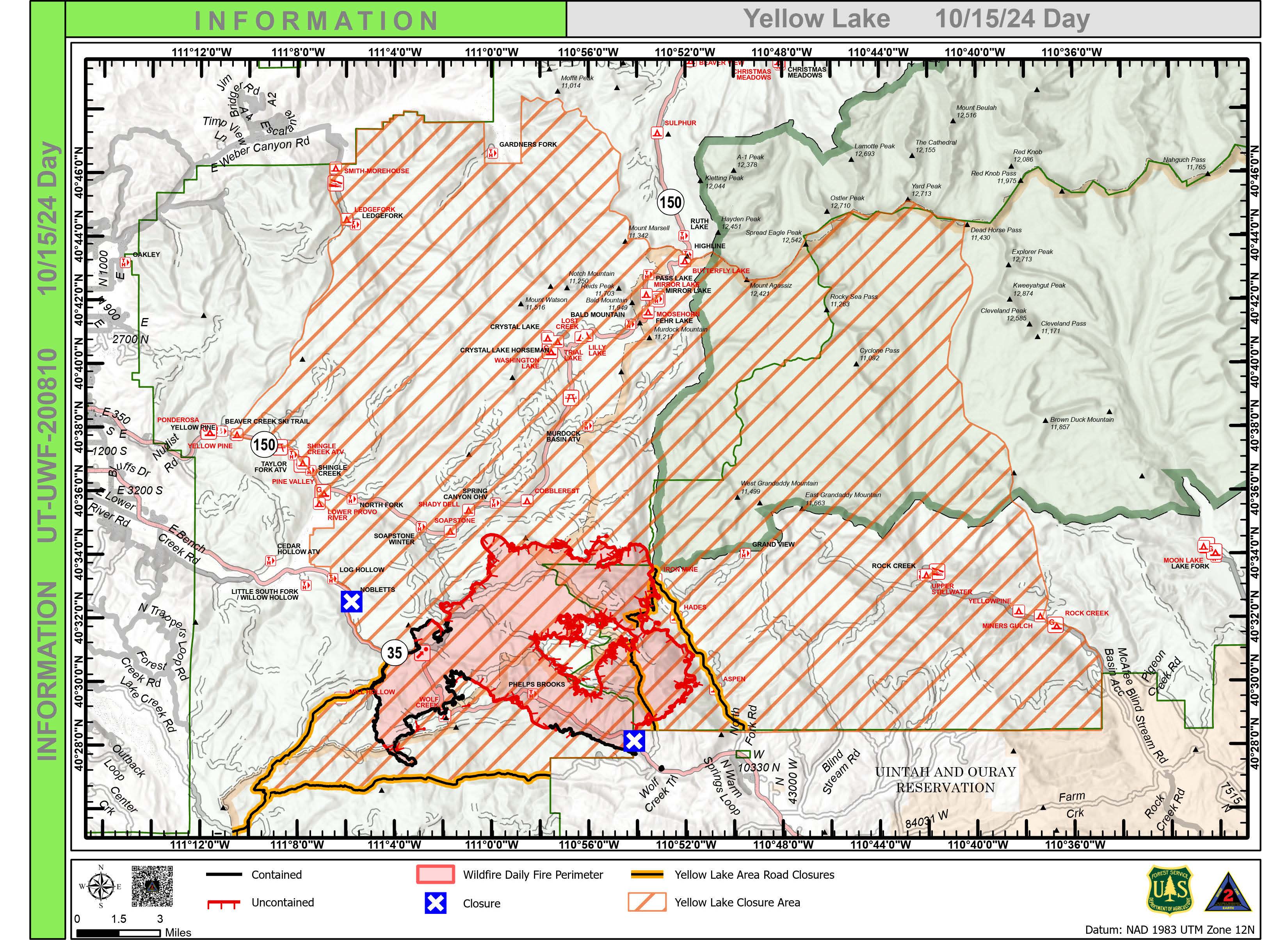
Size at time of update: 31,193
Containment: 29%
Personnel: 889
Start: Saturday, September 28, 2024
Cause: Undetermined
Location: 10 miles southeast of Francis, Utah
The most active part of the fire occurred in the northwest finger as burning snags continued to glow overnight. Jackpot fuels occasionally flared in the Iron Mine Lake area. Fire managers praised the Uinta-Wasatch-Cache National Forest on previously completed fuel thinning projects. The fuel breaks slowed fire progression and currently have it in a backing alignment. The multi-year project was implemented to reduce fuels along both sides of Mirror Lake Highway. Water-scooping airplanes and helicopters will continue operations today, dropping water to further cool the fire’s northern edge. Dozers are also reinforcing lines in the area in addition to hand crews.
Some flanking was observed on the east side of the Fire. Along the North Fork of the Duchesne River, the fire continued to slowly back down the slope toward the river. One finger of the fire reached the bottom of the slope near the river, forming an anchor point for fire crews to work from while protecting nearby properties. Crews are employing a point-protection strategy, setting up pumps, hoses, and sprinklers on structures along the North Fork.
On the southeast edge of the fire, dozer and hand crews are constructing a secondary control line away from the fire’s edge running from the West Fork of the Duchesne to the Lookout Mountain area. Dozers are pushing additional fire breaks along Wolf Creek Road while avoiding hazard trees.
Patrol continues on the western flank of the fire, from East Fork Mill Hollow up to Soapstone Mountain, although there has been no recent fire activity. Chipping and fuel removal along the control line is progressing in this area.
All control lines will continue to be strengthened today anticipation of stronger winds on Wednesday followed by a cold front and predicted rain and snow starting Thursday.
All evacuation orders and closures remain in effect.
Forest Closures:
- Updated October 11, 2024, a closure was increased on the Uinta-Wasatch-Cache National Forest due to the Yellow Lake Fire. This Order shall remain in effect until October 31, 2024, unless rescinded. https://www.fs.usda.gov/Internet/FSE_DOCUMENTS/fseprd1208350.pdf
- Updated October 11, 2024, a closure was increased on the Ashley National Forest due to the Yellow Lake Fire. This closure will remain in place through December 31, 2024, or until rescinded, for public safety.
Evacuation Areas: The North and West Forks of the Duchesne River, and Granddaddy Lakes area are under a mandatory GO evacuation meaning all residents, hunters, and recreationists must leave and stay out of the area. Hanna is under a SET order, advising residents to have bags packed and be prepared to evacuate if necessary.
For updated evacuation zones, please visit:
https://emergency-management-operations-wasatch.hub.arcgis.com/
https://tricountyemergencyalert.genasys.com/portal/en
https://www.fs.usda.gov/Internet/FSE_DOCUMENTS/fseprd1208878.pdf