
Single Publication
Could not determine your location.
 Wildfire
 Prescribed Fire
 Burned Area
Response
Burned Area
Response Other
Other
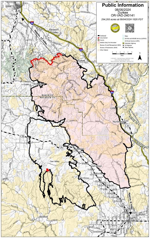
Durkee Fire
Unit Information
Agency Name: Bureau of Land Management

Agency Name: Bureau of Land Management
Incident Contacts
Durkee Fire Daily Update 8/6/2024 08-06-2024
Durkee Fire
Publication Type: News - 08/06/2024 - 12:23
DURKEE FIRE
- Size: 294,265 acres
- Containment: 90%
- Location: 1 mile west of Durkee, OR
- Start Date: July 17, 2024
- Personnel: 362
- Cause: Lightning
Current Situation
Today’s weather conditions are ideal for new fire starts; please remain vigilant in respecting closures and fire restrictions to help prevent human-caused wildfires. Fire danger is rising daily.
There was a new start south of the Pleasant Valley area and west of Alder Creek Road yesterday. Durkee Fire resources worked with local responders to quickly suppress the 10-acre wildfire.
Yesterday, firefighters increased containment to 90% using infrared data and an unmanned aircraft system (UAS or drone) to identify and extinguish hotspots. Total reported fire acreage decreased slightly due to improved mapping data. Fire crews continued to patrol and secure fire lines, with an emphasis on the north and northwestern portions of the fire. Where possible, crews worked in coordination with resource advisors to repair areas disturbed by wildfire suppression operations. Crews continued to remove surplus equipment for transport to a federal incident support cache for maintenance and repair. Supplies and equipment are sent out multiple times each year decreasing the need to make new purchases.
Today, crews will continue patrolling for any residual heat, supporting suppression repair, and mapping dozer and handlines for future repair. Firefighters and aircraft are available for initial attack if needed.
Tomorrow, the Durkee Fire will be transitioned back to the local units at 8 p.m. PDT.
Weather and Fire Behavior
Today, there is an increase in the threat of fire weather conditions and fire danger due to today’s very hot and dry weather. This prolonged period of above average temperatures and dry conditions is expected to continue as well as the increase in fire danger. Relative humidity will be in the teens and possibly single digits today. Tomorrow relative humidity will be even lower, expected around eight to nine percent. The fire potential outside the fire footprint is higher than the potential inside the footprint.
Evacuations
The Malheur County Sheriff’s Office (https://www.facebook.com/profile.php?id=100069245917855) and the Baker County Sheriff’s Office (https://www.facebook.com/profile.php?id=100064434892363) have issued evacuation orders for multiple areas during the Durkee Fire. Please continue to be vigilant and stay tuned to their Facebook pages for the latest information as weather patterns and fire activity may change evacuation levels.
Residents in Level 3 Evacuations “GO NOW” should leave immediately and not return to their property until evacuation levels are lowered. Carry enough supplies to support you and your family for multiple days. A real-time map of fire evacuations is available on the State of Oregon Fire Dashboard (https://www.arcgis.com/apps/instant/portfolio/index.html?appid=22d04c007866419c91ccf00d097526c8).
Closures:
- The Baker County Sheriff's Office has closed Burnt River Canyon Road to non-local, non-emergency traffic.
- I-84 and other highways: Please go to tripcheck.comfor current road closures as the situation is subject to change.
- A burn ban is currently in effect for all of Malheur County (https://www.malheurco.org/category/public-notices), and all Bureau of Land Management lands in Malheur and Baker counties. The Wallowa-Whitman National Forest remains in public use restrictions and IFPL4.
- The temporary flight restriction has been reduced over the Durkee Fire. More information is available at https://tfr.faa.gov/save_pages/detail_4_2285.html. Remember, if you fly we can’t! If a drone or other aircraft enters the air space, all firefighting aircraft will be grounded.
Additional Resources:
- For current air quality information, visit fire.airnow.gov.
- Weather and fire behavior could impact transportation, power transmission, cell service and other utilities. Monitor IdahoPower.com for information.
- Post-fire resources for eastern Oregon livestock and agricultural producers are available. For immediate assistance associated with livestock, forage, and crop losses contact your county’s USDA Farm Service Agency (FSA) office. Learn more about these and other disaster relief programs at www.farmers.gov/protection-recovery/wildfire and contact your FSA Service Center.
- For technical expertise regarding livestock, post-fire rehabilitation and land management, call Eastern Oregon Agricultural Research Center at (541) 573-8900.
- Questions related to agriculture and natural resources, family and community health, and more may be directed to the OSU Extension Service office in your county (https://extension.oregonstate.edu/find-us).
- If you don’t have access to a computer and/or internet connection, Extension offices house Ag Disaster Relief Resource Computers, which are available to producers to access federal/state relief programs.
- Oregon Wildfire Response & Recovery website (wildfire.oregon.gov/recovery) provides guidance on topics including wildfire insurance, filing a homeowners claim after the fire, returning to a home that survived a fire, replacing lost or missing documents and next steps for people whose homes or businesses burned.
- For longer term management needs, contact the USDA Natural Resource Conservation Service (NRCS) field office in your county to explore current funding/technical support available and inform future program offerings in your county. Go to www.nrcs.usda.gov/conservation-basics/conservation-by-state/oregon/whats-available-in-my-county.