
Single Publication
Could not determine your location.
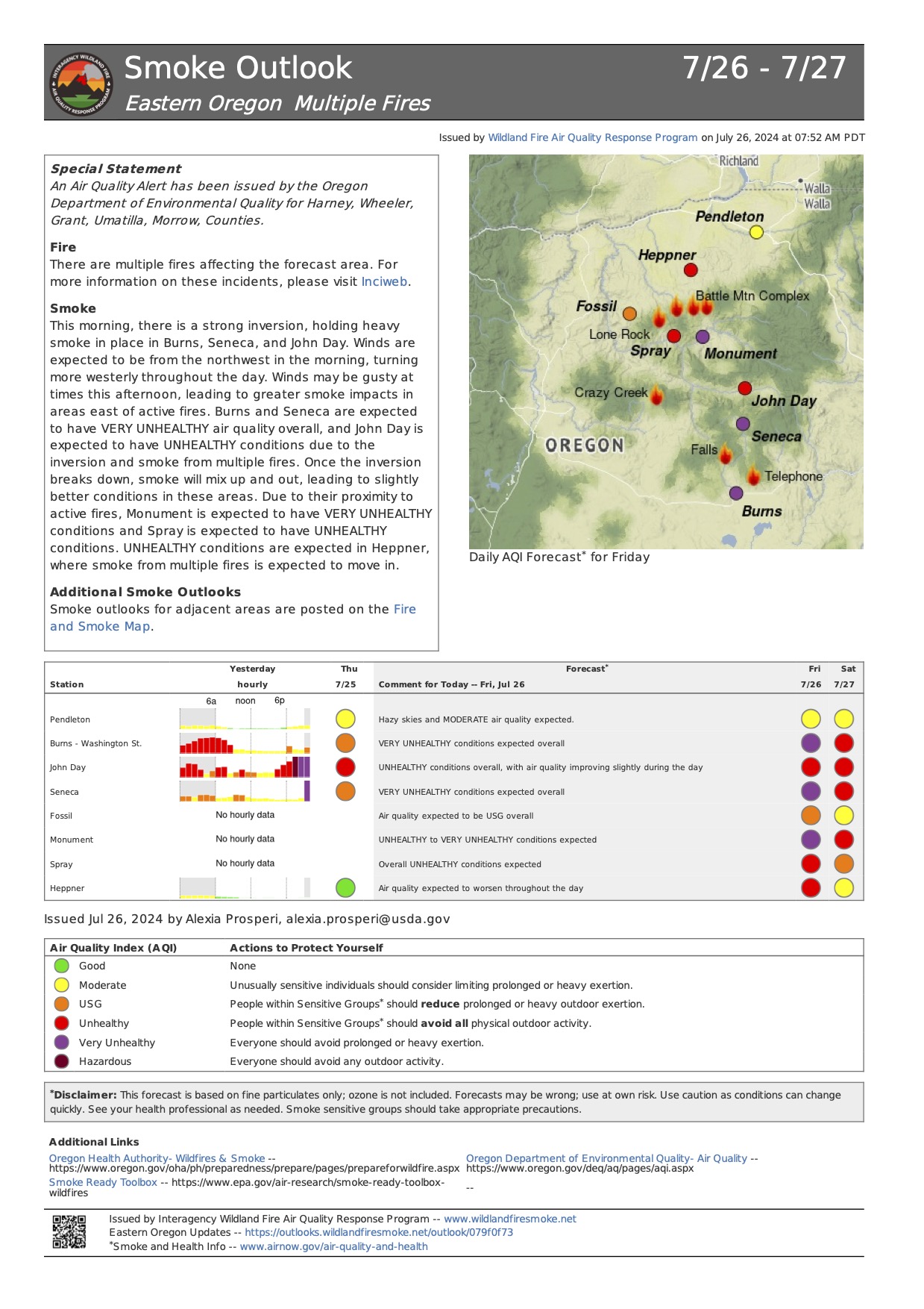
 Wildfire
 Prescribed Fire
 Burned Area
Response
Burned Area
Response Other
Other
Lone Rock Fire
Unit Information

Incident Contacts
- Fire InformationPhone:541-416-6700Hours:7:45 a.m. to 4:30 p.m.
Lone Rock Fire Update July 26, 2024 07-26-2024
Lone Rock Fire
Publication Type: News - 07/26/2024 - 08:00
LONE ROCK FIRE UPDATE July 26, 2024
Location: Lonerock, Ore. to west of Highway 207 | Size: 136,561 acres | Containment: 45% Cause: Under Investigation
Start Date: July 13, 2024 | Total Personnel: 926
InciWeb: https://inciweb.wildfire.gov/incident-information/orprd-lone-rock-fire
Fire Information Line: 541-208-4369
Email: 2024.0404rvlonerock@firenet.gov
Condon, Ore. — The Lone Rock Fire is being managed under a full suppression strategy by the unified command of the Northwest (NW) Team 2 and Oregon State Fire Marshal (OSFM) Red Team.
There will be a community meeting tomorrow, Saturday, July 27 at 6:00 p.m. at the Grade School Gym located at 392 Main Street, Fossil, Ore. The meeting will also be available on the Lone Rock Fire Facebook page.
Yesterday’s Activities: Crews were successful at keeping the fire within its existing footprint and continued to focus on patrol and mop-up operations. Minimal to moderate fire behavior was observed across the entire fire area. Containment of the Lone Rock Fire increased to 45 percent.
Hoselays were put in place at the previous spot fire near Notch Road, and firefighters were able to use these resources to assist in mop-up operations there. Crews also completed strategic firing operations yesterday morning to better secure the spot fire near Flatiron Spring.
Firelines held well in the southern portion of the fire, including along OR 19 and Alder Creek Road. Crews continued to monitor and mop-up isolated interior hot spots. North of Forest Service Road (FSR 25), crews worked to complete a small firing operation to remove the remaining unburned fuels. As of 8:00 p.m. on Thursday evening, OR-19 and OR-207 were fully reopened to traffic.
Today’s Activities: The focus today will be on continuing to mop-up and patrol existing line across the fire area, as well as further securing the spot fires on the east and west sides of the fire perimeter. Lines have held around these areas of concern for several days now. Crews are evaluating the unburned pocket of fuels on the west side of the fire and may conduct strategic firing operations if necessary.
Due to the tremendous work by firefighters and the completion of mop up work around homes, the threat to structures has reduced greatly. As a result of that progress, some Oregon State Fire Marshal (OSFM) task forces and the OSFM incident management team will complete their shift today and then be reassigned to nearby fires or return home to protect their local communities on Saturday. The OSFM Red Team and all of its structural firefighters that have protected Spray, Ore. and served on the fire would like to thank the communities affected by this fire for their support.
Evacuations:
- For information on evacuations in Gilliam County, visit Gilliam County Sheriff's Office Facebook page.
- For information on evacuations in Wheeler County, visit Wheeler County Sheriff’s Office Facebook page.
- For information on evacuations in Morrow County, visit Morrow County Sheriff's Office Facebook page.
Shelters:
• An evacuation center has been set up at the Wheeler High School (600 E B Street, Fossil, Ore.). A large animal shelter is available at the County Fairgrounds (720 E 3rd Street in Fossil, Ore.).
Closures:
• OR-19 and OR-207 were fully reopened to traffic on Thursday, July 25 at 8:00 p.m. For updated
road closure information, visit https://www.tripcheck.com/.
Weather: Friday will be a little warmer with temperatures in the upper 70s and 80s, and relative humidity values in the teens. Winds will shift to northeasterly on ridge tops, but a little weaker with sustained speeds of 4-7 mph.
- Umatilla National Forest Order Number 06-14-02-24-02 includes prohibitions within the Heppner Ranger District on the Umatilla National Forest.
- Bureau of Land Management Prineville District Office issued an Emergency Public Land Closure on BLM-managed lands along the main stem John Day River from Kimberly, Ore. to Dale, Ore.; and along the North Fork John Day River from Kimberly, Ore. to Dale, Ore.
Smoke Information: Visit https://fire.airnow.gov/ for local air quality information.
Flight Restrictions: A Temporary Flight Restriction (TFR) is in place above the Lone Rock Fire area. Unauthorized drone flights (UAS) pose serious risks to firefighter and public safety and the effectiveness of wildfire suppression operations.
###