
Single Publication
Could not determine your location.
 Wildfire
 Prescribed Fire
 Burned Area
Response
Burned Area
Response Other
Other
Telephone Fire
Unit Information
Incident Contacts
- Telephone Fire Information (same as Falls Fire)Email:Phone:541-208-4370Hours:8 AM - 8 PM
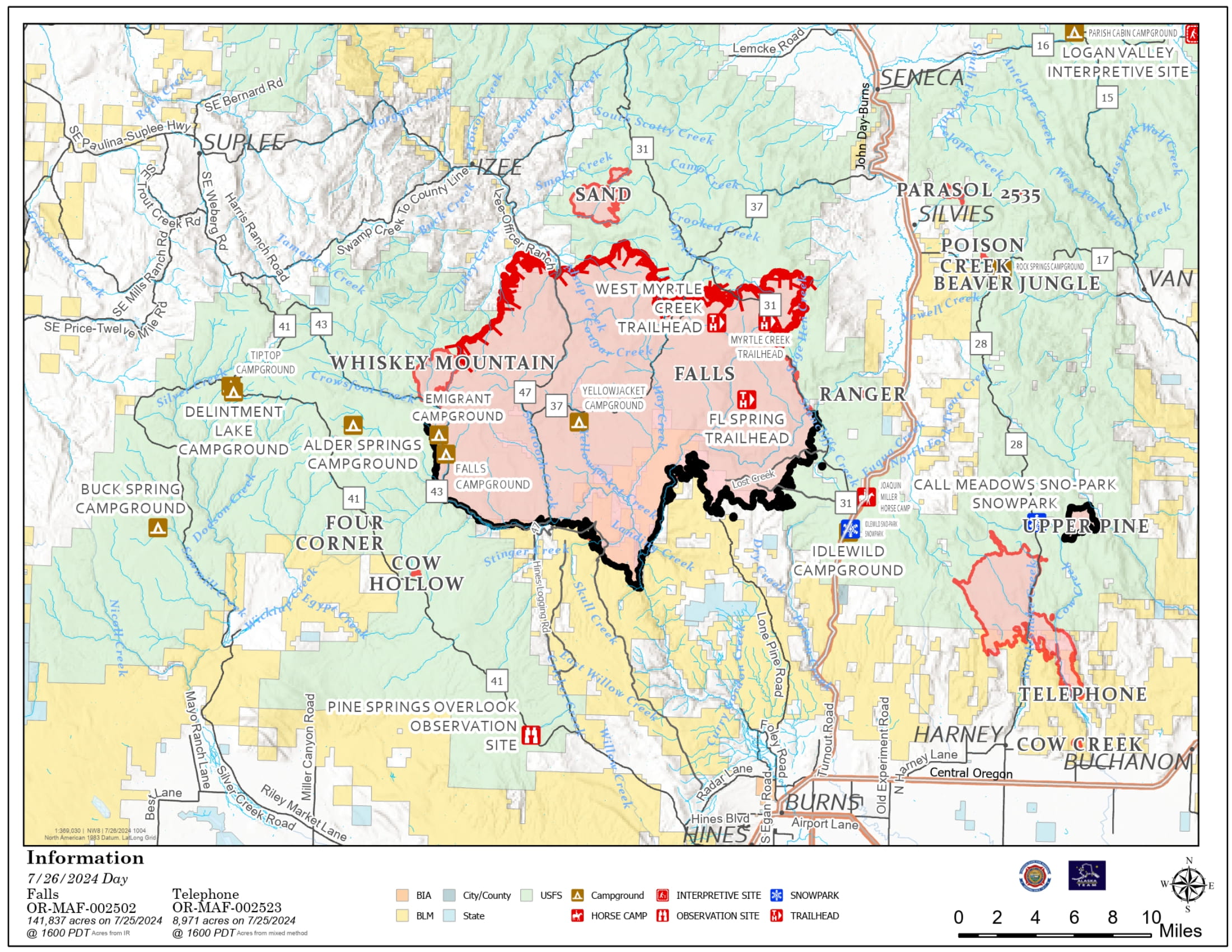
Falls and Telephone Fires Update 07-26-2024
Falls Fire, Telephone Fire
Publication Type: News - 07/26/2024 - 10:33
Falls and Telephone Fires Update for July 26, 2024
Falls Fire Quick Facts:
Size: 141,927 Start Date: July 10, 2024 Location: 13 Miles NW of Burns, OR
Containment: 55% Total Personnel: 1,558 Cause: Human-caused, under investigation
Structures Triaged: Residences: 377; Commercial: 118 Outbuildings: 677
Resources Assigned: 38 hand crews, 79 engines, 24 bulldozers, 25 water tenders
Aerial resources available to the fire: two helicopters, and single-engine air tankers (SEATS)
Telephone Fire Quick Facts:
Size: 12,180 Start Date: July 22, 2024 Location: 12 miles NE of Burns, OR
Containment: 0% Total Personnel: Staffed by Falls Fire personnel Cause: Lightning/Natural
New Fire Activity Quick Facts:
Whiskey Mountain: 2,565 acres; Cow Creek: 85 acres; Sand: 2,733 acres; Parasol: 353 acres; Poison: 39.6
Alaska Complex Incident Management Team 1 assumed command of Falls and Telephone Fires at 6:00 am Friday morning and remains in Unified Command with Oregon State Fire Marshal (OSFM).
Thursday afternoon, strong afternoon winds coupled with extremely dry fuels increased fire behavior on the Telephone Fire. Several new fire starts were located to the east of Falls Fire in the Parasol Butte area. Evacuation levels were issued and extended due to the new starts and Telephone Fire’s move across FSR28.
Crews assigned to the Falls Fire responded to new starts and the expanding Telephone Fire, along with aerial resources, to minimize the impact of fire growth. Structure protection crews quickly mobilized and also responded to the area. Telephone Fire has grown 3,000 acres and moved further to the southeast overnight and is approximately 4 miles north of Hwy 20.
Falls Fire: On Thursday, control lines continued to hold in areas where homes were previously threatened, including the Red Hill area and the Izee community. Prep has been completed by wildland and structure crews within the area directly adjacent to the Sand Fire, where the fire is steadily moving away from structures. This allowed OSFM assets to shift to the Telephone Fire, as fire activity moved to the northeast. Structural assets also continue to patrol the Highway 395 corridor, protecting properties to both the east and west. Structure crews responded alongside wildland resources to the Parasol Butte area to address structural protection related to multiple new fires in the area. This work continued overnight, with crews identifying structures and evaluating protection needs.
Crews on the southern and western perimeter continued to reinforce control line and mopped up additional hot spots. On the western side, firefighters conducted burn operations to tie the Whiskey Mountain Fire into the Falls Fire. Fire crews utilized direct attack and firing operations to protect resources to the west, including Izee. To the northwest, firefighters worked to tie together portions of control line using dozers and hand crews. On the northeast side, crews advanced fireline on the FSR31, moving west along Lonesome Creek with the assistance of heavy equipment. On the eastern edge, work progressed along FSR31, with fuel removal and mop up.
Today, crews will continue to mop up and hold areas on the south end of the Falls Fire. To the west, direct and indirect firing tactics will be used to tie Whiskey Mountain Fire into the Falls Fire and existing road lines.
Telephone Fire: On Thursday, the fire experienced significant growth to the south and southeast and crossed FSR28 and Military Road. The fire has crossed Cow Creek, as well as Little Cow Creek. Crews remained engaged in suppression efforts and worked alongside night shift for several hours. The plan for Friday is to continue tying in firelines in the north and to look for opportunities to anchor the fire near FSR28.
Focus has shifted the structural resources north of Highway 20, throughout the Cow Creek area and continuing east. Overnight, OSFM assets assigned to the Telephone Fire continued to patrol the structures to the south and southeast of the fire area. Friday, crews will continue to identify, assess and begin to prep homes in the area affected by the updated level 3 evacuation zone. This work is being prioritized on homes directly adjacent to the fireline.
Although Thursday was another active day, the threat to structures does still continue to trend downward. As part of the structure risk reduction, the number of surveyed and prepped structures has increased. This means that the location of structures is mapped, ensuring crews will know the best access routes, should they become threatened. The prep work that has been completed ranges from surface to full prep, depending on proximity to the fire. These extensive efforts help mitigate the risk to structures should the fire front move through the area.
New Starts: There were multiple new fires reported Thursday inside the Falls and Telephone Fire Temporary Flight Restriction (TFR) area. Resources assigned to the Falls Fire engaged in initial attack (IA). The largest of these starts is the Parasol Fire, located near Parasol Butte. It is estimated at around 353 acres. An additional start located near Poison Creek, was approximately 40 acres. Resources from multiple locations from the Falls Fire were assigned to both new starts. Firefighters will remain on the Parasol and Poison fires Friday and will work direct on the fire’s edge where possible. Firefighters assigned to the fires around the Falls Fire will respond to any new starts.
The Sand Fire, which is burning near Sand Mountain north of the Falls Fire, was discovered yesterday. Air resources assisted ground forces with suppression efforts and made steady progress throughout the day. OSFM Task Forces provided structural protection. Crews took advantage of cooler night temperatures to conduct strategic firing operations, in conjunction with heavy equipment, to create control lines. OSFM crews will work to complete protection work on structures in the vicinity.
Weather: Smoky conditions will continue through the morning. An inversion layer sits over the fire and is expected to lift by early afternoon. Temperatures will remain slightly lower today and will stay in the mid-80’s. Skies will generally be clear by afternoon. Like Thursday, northwesterly winds will become westerly and breezier in the afternoon before returning to northeasterly. Gusty winds can be expected over the fire again later today.
Evacuations: Evacuations remain in place in both Grant and Harney Counties and have expanded to include Level 3 evacuations due to the Telephone, Parasol and Poison Fires. For the most accurate evacuation information, please visit the Harney County Sheriff’s evacuation map here: https://tinyurl.com/3zst4sjy, or the Grant County Emergency Management Facebook page at: https://www.facebook.com/profile.php?id=100068819321423.
Closures: Due to active wildfires compounded by extremely unfavorable weather conditions, limited firefighting resources and County Resources, Malheur National Forest officials have temporarily closed lands within the Malheur National Forest.
Investigation: U.S. Forest Service fire investigators are seeking the public’s assistance with any tips or information pertinent to the start of the Falls Fire on the Malheur National Forest. Please submit any information that could assist fire investigation efforts to SM.FS.R6TipHotLine@usda.gov.
Facebook: https://www.facebook.com/p/Falls-Fire-2024-61562126623985/
Falls Fire InciWeb: https://inciweb.wildfire.gov/incident-information/ormaf-falls-fire
Telephone Fire InciWeb: https://inciweb.wildfire.gov/incident-information/ormaf-telephone-fire
Fire Information Line: 541-208-4370, staffed 8 a.m. to 8 p.m.
Email: 2024.Falls@firenet.gov
Harney County non-emergency evacuation questions: 541-589-5579
Air quality questions: 541-573-2271
Smoke Outlooks: https://outlooks.airfire.org/outlook