
Single Publication
Could not determine your location.
 Wildfire
 Prescribed Fire
 Burned Area
Response
Burned Area
Response Other
Other
Battle Mountain Complex
Unit Information
Incident Contacts
- Battle Mtn Complex Fire InformationPhone:541-612-0744Hours:7:00 am - 7:00 pm
Battle Mountain Complex 07-21-2024
Battle Mountain Complex
Publication Type: News - 07/21/2024 - 09:30
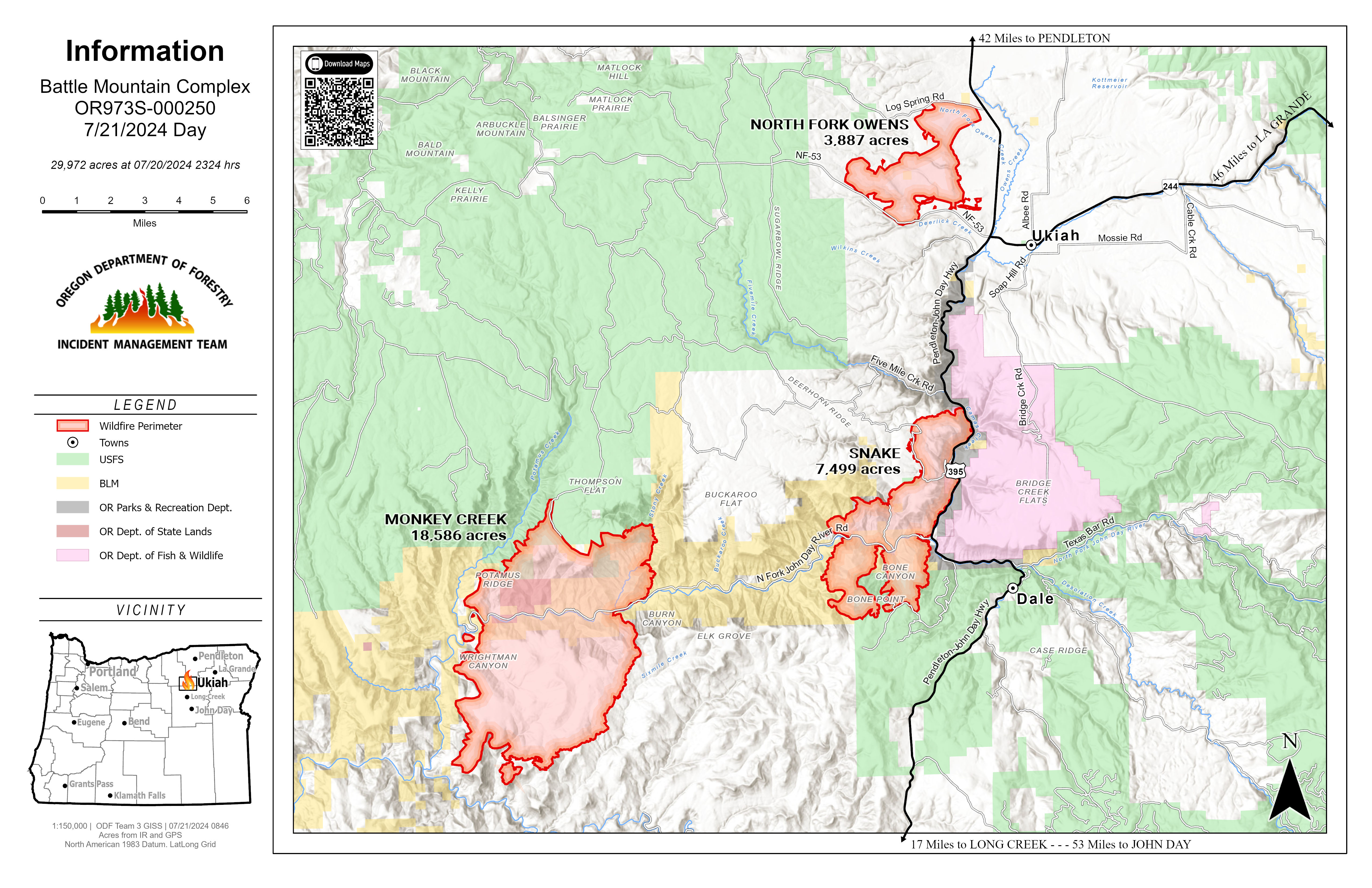
Battle Mountain Complex expands to include the Monkey Creek Fire, total acreage increases to 30,272
UKIAH, Ore. – This morning, ODF Incident Management Team 3 added the 18,886-acre Monkey Creek Fire to the Battle Mountain Complex, which also includes the 3,887-acre North Fork Owens Fire and the 7,499-acre Snake Fire, bringing the total estimated acreage to 30,272.
“Each fire is in a different stage of operations,” said Operations Section Chief Eric Perkins. “We have a lot of crews beginning mop-up along large portions of the North Fork Owens Fire, and we’re constructing a lot of active fireline on the Snake Fire. We’re doing our best in very steep terrain and critical weather. Firefighter and community safety is our top priority.”
While firefighters are engaged on the Monkey Creek Fire, much of today will be focused on scouting and determining resource needs.
Overnight, crews focused most of their efforts on the Snake Fire protecting homes along the North Fork John Day River. They had little growth on the northwest side of the Snake Fire and focused dozer lines on the head of the fire along the south.
Overnight, firefighters were able to hold the North Fork Owens Fire within its current perimeter. Crews patrolled the lines and hand crews began cold trailing portions of the fire. Firefighters will continue mop-up operations. Residents can expect to see smoke from the interior.
Today, crews will continue to focus on constructing and improving as much dozer and handline where they can on all three fires. Firefighters continue to face challenges of limited resources, difficult terrain and Red Flag Warnings with a chance of lightning in the evening.
Closures: A road closure remains in effect for Highway 395, between mile posts 50 through 90, beginning 35 miles South of Pilot Rock.
Evacuations: Level 1 (Be Ready) , Level 2 (Be Set) and Level 3 (Go Now) evacuations are in effect. For updated evacuation information, visit the Umatilla County Sheriff's Office Facebook page, www.facebook.com/UmatillaCountySheriff, or sign up for the Umatilla County Emergency Alert System at https://member.everbridge.net/index/2590041373147145.
For current area fire info, go to http://bluemountainfireinfo.blogspot.com/ or ODF NEO Facebook: www.facebook.com/oregondeptofforestryNEO/. To report a fire, call Blue Mountain Interagency Dispatch at (541) 963-7171 or dial 9-1-1.