
Single Publication
Could not determine your location.
 Wildfire
 Prescribed Fire
 Burned Area
Response
Burned Area
Response Other
Other
Smith River Complex
Unit Information
Incident Contacts
- Phone:South: 707-383-9727 North: 541-801-3495Hours:8 a.m. - 8 p.m.
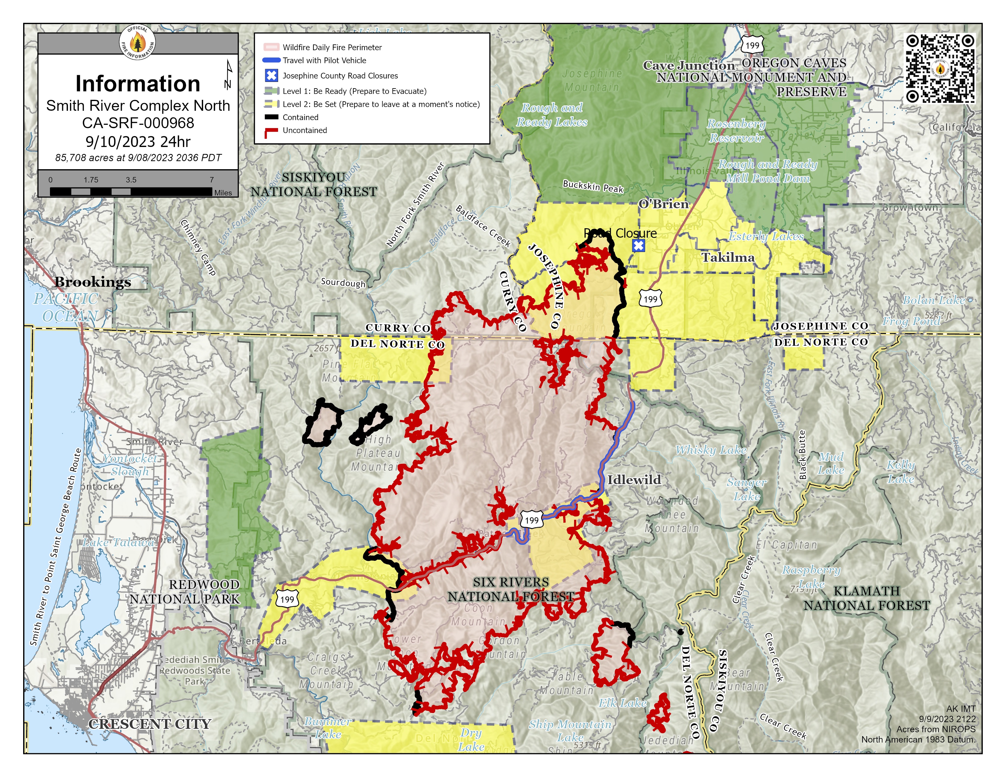
Update for Smith River Complex North, Sunday, September 10, 2023
Smith River Complex
Publication Type: News 09/11/2023
Smith River Complex-North
Update for Sunday, September 10, 2023
Location: Grants Pass, OR
Size: 85,708 total, 10,276 in Oregon
Total Personnel (for Complex): 2,012
Resources: 52 crews, 10 helicopter, 87 engines, 16 bulldozers, 29 water tenders, 19 masticators, 2 skid steers
Containment: 20%
Start Date: August 15, 2023
Cause: lightning
Yesterday: Successful strategic burning operations continued on the north side of the Smith River Complex, near Forest Road 019. Burning operations allow firefighters to choose where and when to engage the fire; it is a safe and effective strategy to reduce fuel loads, combined with use of terrain and natural features to halt progress of the main fire. While substantial work remains for Pacific Power, they initiated steps to re-energize power lines and restore power to affected communities. For more information, see an announcement at: tinyurl.com/PacificPowerNews.
Today’s activities: With persistent warm, dry weather and light breezes, firefighters expect to pursue additional burning operations near the north end of the fire. The crews on the west side of the fire are working together to get machinery into the Forest Road 1106 area to develop a contingency line. Monitoring along the fire perimeter is ongoing, searching for hot spots, and improving fire lines. Firefighters on the east side are beginning to look for opportunities to initiate suppression repair, or to mitigate damage from firefighting and minimize potential soil erosion and impacts.
Evacuations: Monitor Rogue Valley Emergency Management site and sign up for evacuation alerts and updates at rvem.org. An interactive Fire First Response Map with evacuation areas can also be found there.
Smoke: Smoke Forecasts are available at oregonsmoke.org
Closures: The Rogue River-Siskiyou National Forest and Bureau of Land Management Coos Bay District have issued area and road closures for the Smith River Complex. A campfire ban remains in place for BLM and forest lands, and the Wild section of the Rogue River. Visit bit.ly/RRSNFAlerts or www.blm.gov/orwafire for additional information.
US-199 is open and is the recommended travel route. Hazards from fire damage remain along US-199 and traffic may be delayed intermittently for 20 to 60 minutes with one-lane pilot car escorts. Please use extreme caution; firefighting efforts are ongoing. The Del Norte Sheriff’s Office is asking residents to refrain from any unnecessary travel along that route. Please do not follow mapping systems that direct you to leave the US-199 corridor; alternate routes are in a fire closure area that is not suitable for travel. It is unsafe for you and our fire personnel. For additional information on road conditions, please see the roads.dot.ca.gov and Oregon Department of Transportation's tripcheck.com.
Restrictions: Please respect the temporary flight restriction (TFR) established for the Smith River Complex; keep drones away from firefighting operations. If you fly, we can’t. Don’t be the reason a firefighting air mission has to divert! For more information on the TFR, visit tfr.faa.gov.