
Single Publication
Could not determine your location.
 Wildfire
 Prescribed Fire
 Burned Area
Response
Burned Area
Response Other
Other
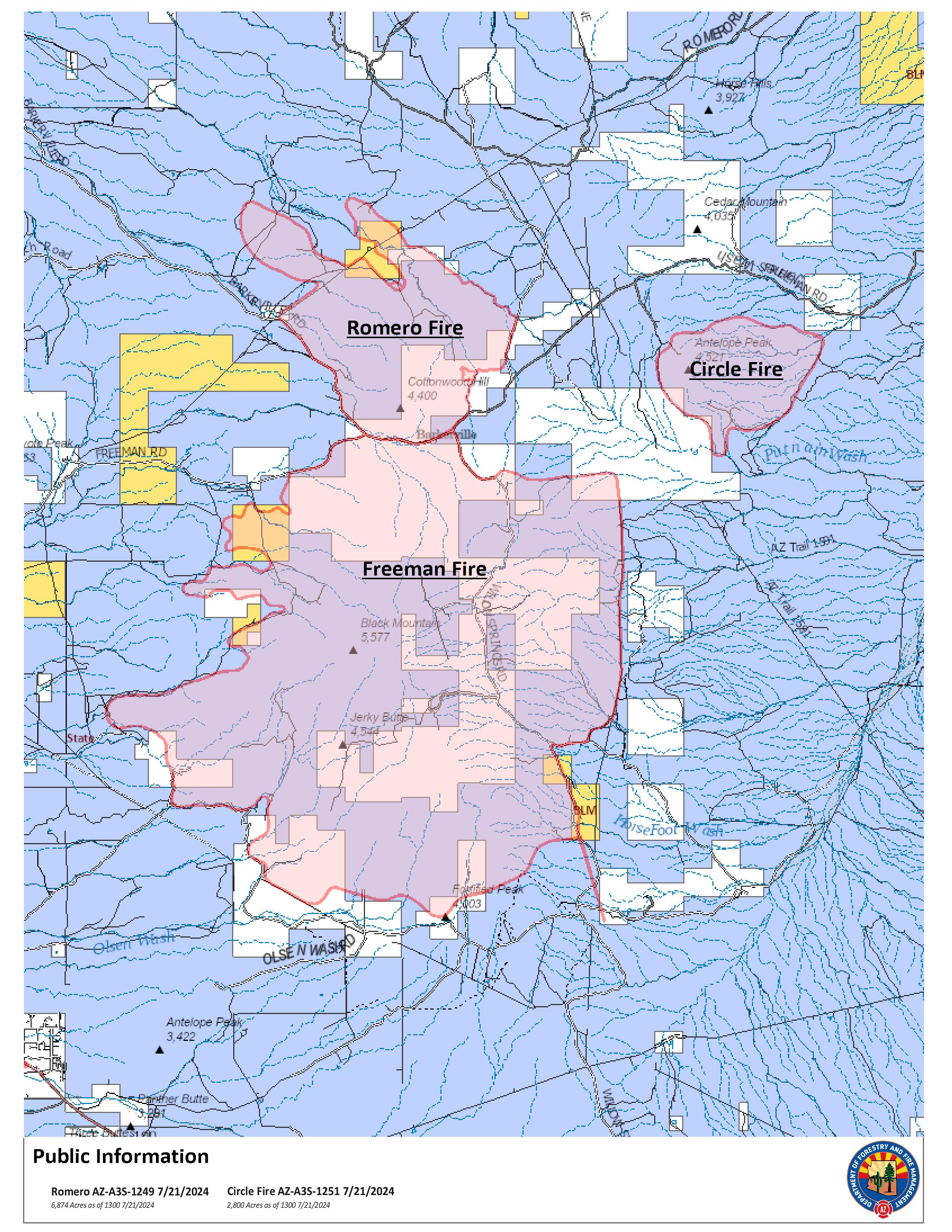
Circle Fire Update 07-21-2024
Circle
Publication Type: News - 07/21/2024 - 13:30
Circle Fire Update Sunday, July 21, 2024
Start Date: Friday, July 19, 2024 Cause: Undetermined
Location: 14 miles south of Kearny Acres: 2,800
Personnel Assigned: 90 Containment: 0%
Evacuation: SET for 3C Ranch
Summary: The fire was discovered Friday, July 19, 2024 with an unknown cause. When it is safe to do so, an investigation will be conducted to determine the cause. The fire is burning in grass and brush northeast of the Freeman Fire that occurred last week.
On Saturday, crews had a productive shift working to secure the south end of the fire that was initially estimated at 100 acres burning at the base of Antelope Peak. Firing operations were utilized to strengthen line on the southern perimeter as well as the east side. A thunderstorm moved over the fire area in the early evening, producing gusty, erratic winds up to 50 mph. These outflow winds created a 180-degree wind shift that pushed the fire east. On the east end of the fire, two dozers worked ahead of the wind-driven fire to widen a two-track road. This road was connected to a wash and as of yesterday evening, the fire had not crossed this containment line. The fire moved through pockets of heavy fuel, burning within mesquite, grass, brush, and desert shrub. Dozer operations allow for faster suppression work in areas suitable for the heavy machinery. Firing operations and weather influence throughout the day produced a column of smoke visible to the surrounding communities of Oracle, Mammoth, Kearny and those traveling SR 79 and SR 77.
Today, operations will continue to secure the fire’s edge using crews and a dozer. With close proximity to the Romero Fire, resources may move between the two fires to provide support based on operational needs. Aircraft is available to support the fire with a mapping mission planned for later today.
Communities within proximity of the fire may see smoke and flames today as temperatures warm up and likely increasing fire activity. Storm chances are increasing with the possibility for high winds over the fire area later this afternoon. Outflow winds could result in extreme fire behavior similar to yesterday.
At this time there is no threat to nearby communities. The fire is approximately 14 miles from Kearny. Residents in Pinal County can sign up for emergency alert notifications at: https://www.pinal.gov/1335/PENS---Pinal-Emergency-Notification-Syst.
Closures: Freeman Road is closed. Deputies will be placed at roadblocks throughout the fire area. The public is asked to avoid the fire area, including Barkerville and Willow Springs Roads. The AZT (Arizona Trail) is closed between Oracle and Kearny. Hikers should plan an alternate route.
Weather: Yesterday, thunderstorms moved into the area late in the evening and scattered precipitation was received. The amount is unknown but fire behavior did moderate during the storm. Sunday weather will be mostly sunny with a chance of thunderstorms moving in this afternoon.
Safety: A TFR (Temporary Flight Restriction) is in place over the fire. Firefighting aircraft and drones are a dangerous combination. Drones in the area could lead to accidents or slow down wildfire suppression operations. If you fly…we can’t.
Fire Restrictions: Stage 1 fire restrictions in effect on State Trust lands in Pinal County. Restriction info: http://wildlandfire.az.gov/.
Incident Information: https://inciweb.wildfire.gov/incident-information/aza3s-circle
Twitter: @azstateforestry: https://twitter.com/azstateforestry
Facebook: Arizona Department of Forestry and Fire Management: https://www.facebook.com/arizonaforestry
Ready, Set, Go: https://ein.az.gov/ready-set-go