Single Publication
Could not determine your location.
Grapefruit Complex
Unit Information
Agency Name: Bureau of Land Management

Agency Name: Bureau of Land Management

Incident Contacts
- Alaska Interagency Fire Information OfficeEmail:Phone:(907) 356-5511
Grapefruit Complex Daily Update 07-08-2024
Grapefruit Complex
Publication Type: News - 07/08/2024 - 11:26
Grapefruit Complex
Daily Update: Monday, July 8, 2024
Alaska Incident Management Team 3
Incident Commander- Peter Butteri
Location: 40 Miles north of Fairbanks
Complex Acres: 87,434
Personnel: 236
Containment: 0%
Completed Structure Preparation: 85%
Crews are working toward finalizing structure protection measures, documenting assessment data, and collecting equipment no longer needed for operations. The work around the Native Allotments, included utilizing a masticator and crews to put in a fire break, has been completed. Slight showers continued to fall over the area Sunday, and 2-4” of rain were measured in the days since the rain event began. The forecast for Monday predicts drier conditions with only a chance of light rain over the fire. Partly cloudy skies with chilly temperatures are expected. Temperatures will be in the low to mid-40s, with highs struggling to reach 60. Minimum relative humidity will be 50% or higher. Winds will continue from the southwest, with gusts to around 18 mph.
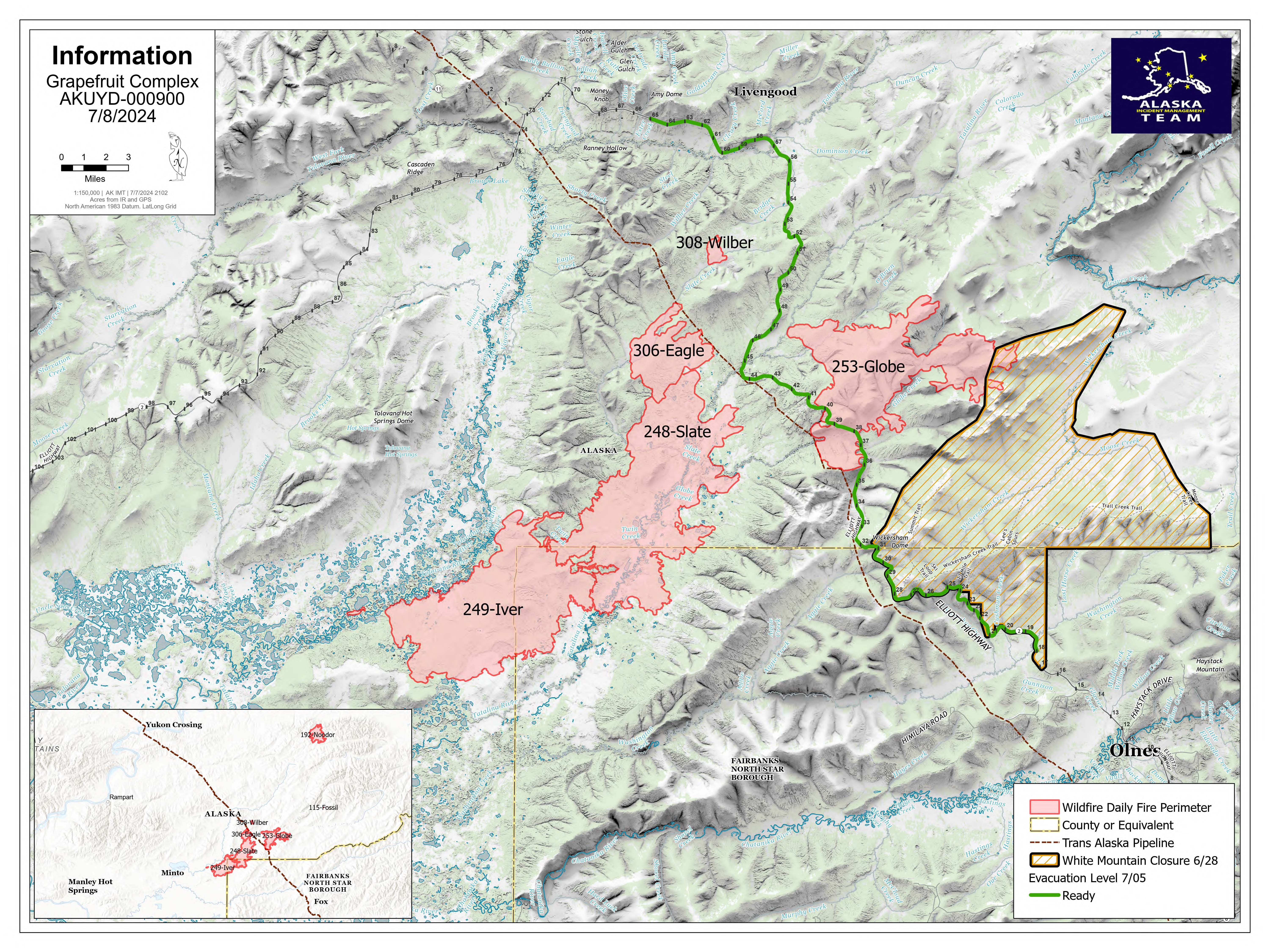
The Grapefruit Complex includes the Globe Fire (#253), Iver Fire (#249), Eagle Fire (#306), Wilber Fire (#308), Noodor Fire (#192), and Fossil Fire (#115). Crews continue to limit the fire’s impact on the Elliott Highway, Trans-Alaska Pipeline, Native allotments, and public and private structures, as well as reducing impacts to fish habitat along the Tatalina and Tolovana River corridors.
Evacuations: The current levels are represented as: Ready (Green): Elliot Hwy MM 18-65 / Set (Yellow): None currently. / Go (red): None currently.
Smoke: The fire perimeter is unlikely to change. However, as daytime temperatures rise and fuels dry out, some of the fuels that held heat through the rain event may produce smoke. Turning on your headlights is advised to help ensure the safety of firefighters and flaggers working in the area.
Road access: The Elliott Highway is open. Expect delays between mileposts 25-65 as firefighters work to remove equipment from the Wickersham Dome trailhead area. Alaska Department of Transportation & Public Facilities temporarily repaired the road due to flooding at milepost 57, utilizing one lane and pilot cars to facilitate traffic flow. DOT is working on logistics for two 12-hour road closures, which could begin as early as Today, July 8th. Check https://511.alaska.gov/ for additional road updates.
Temporary Flight Restriction: No TFRs are in place over the fire area.
Closures: The Bureau of Land Management (BLM) Eastern Interior Field Office closed the western portion of the White Mountains National Recreation Area surrounding the Wickersham Dome Trailhead at mile 28 Elliott Highway. The closure is in effect until Sept. 1, unless the BLM determines the area is safe for public use at an earlier time.

 InciWeb