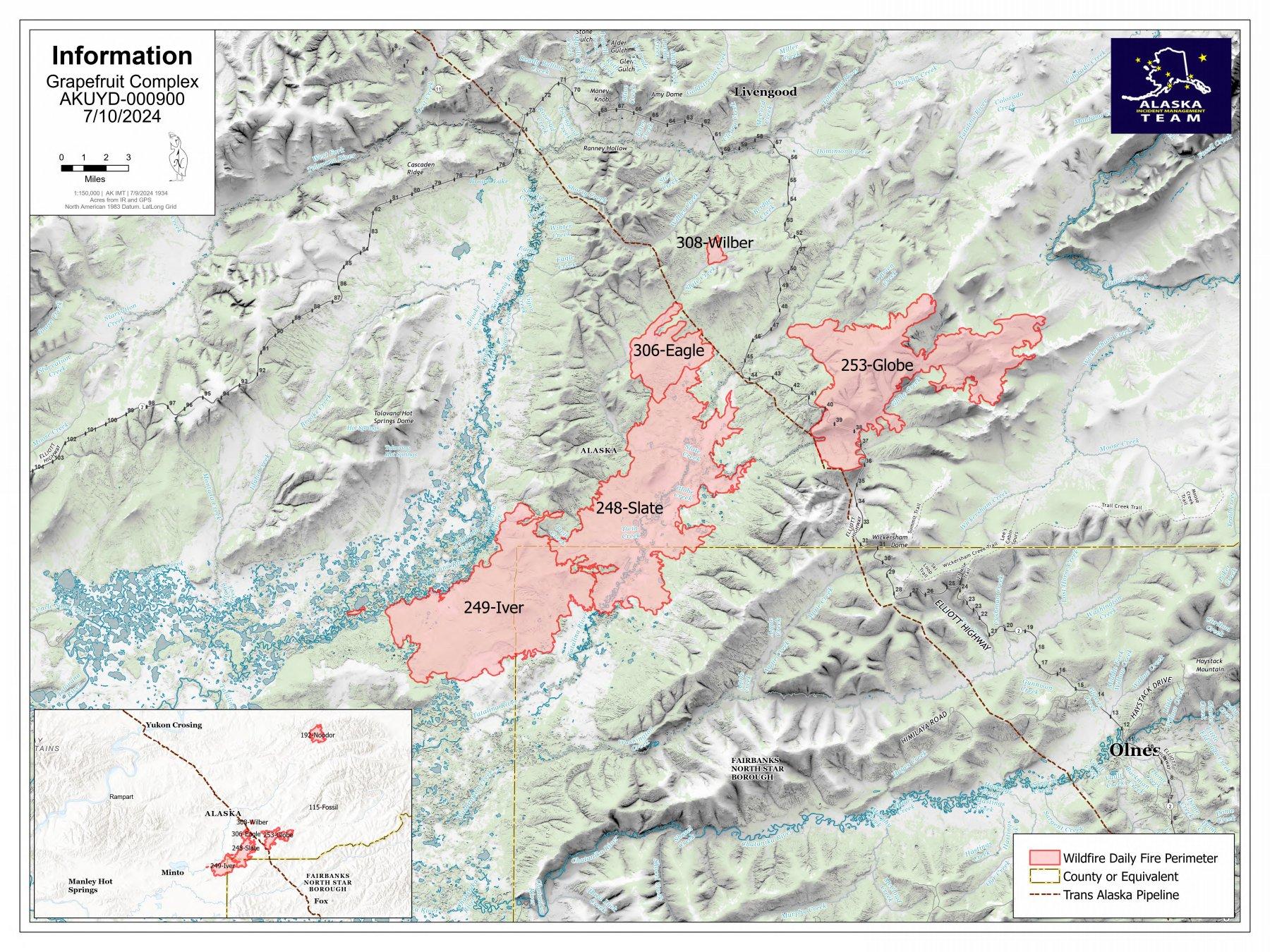
U.S. flag

An official website of the United States government

Here's how you know

Single Incident Information

Zoom to your location
Reset map zoom and position

Could not determine your location.

Grapefruit Complex

Unit Information

P.O. Box 35005 
Fort Wainwright, 
Alaska 
99703 
P.O. Box 35005 
Fort Wainwright, 
Alaska 
99703 

Incident Contacts

Highlighted Activity

EVACUATIONS UPDATED July 1 at 3:00 PM⚠️⚠️Per Alaska State Troopers, additional evacuations have been announced for anyone in the area of the Grapefruit Fire Complex.⚠️⚠️🔴 Go- Red: Elliott Highway Milepost 30-50🟡 Set- Yellow Elliott Highway Milepost 50-60🟢 Ready-Green: Elliott Highway Milepost 18-30 and 60-70Road access:  The Alaska State Troopers are assisting the BLM Alaska Fire Service and the… Read more
Publication Type: Closures -
Alaska State Troopers have released expanded evacuations along the Elliot Highway Corridor for the fires in the Grapefruit Complex. "Go"     Elliott Highway Milepost 30-50 (RED)"Set"     Elliott Highway Milepost 50-60 (YELLOW)"Ready" Elliott Highway Milepost 18-30 and 60-70 (GREEN)There are no road closure per Alaska DOT, but expect significant delays and smoke impacts… Read more
Publication Type: Announcement -

Scenic of large smoke column in Alaska vast forest on the Grapefruit Complex fire.

An Alaska Complex Incident Management team took command of the Grapefruit Complex of six fires burning along the Elliott Highway south of Livengood.

Most of the fires have grown under the hot and dry conditions with predicted wind in the area, more growth is expected. There’s a chance of cooler, moist weather moving into the area starting on Wednesday. While change in weather will bring moisture, there are predicted weather events that will promote extreme fire behavior before the rains are expected. Expect significant delays on the highway due to an increase of fire activity today and predicted weather events throughout the week.

Basic Information
Current as of Tue, 07/02/2024 - 18:24
Incident Time Zone America/Anchorage
Incident Type Wildfire
Date of Origin
Location 30 miles NE of Fairbanks on both sides of Highway 2.
Incident Commander Incident Commander- Peter Butteri
Alaska Incident Management Team 3
Coordinates 65° 23' 27'' Latitude
-148° 17'
44
'' Longitude
Current Situation
Total Personnel: 237
Size 58,153 Acres
Percent of Perimeter Contained 0%
Estimated Containment Date 10/30/24
Fuels Involved

Brush (2 feet), Hardwood Litter, Timber (Litter and understory)

The Fine Fuel Moisture Code (DC) and Duff Moisture Code (DMC) will remain high for next couple of days for the RAWS stations that are used for fire behavior forecast. 

Significant Events

The potential burning in the Globe Complex will continue to remain active but slowly decrease as some
moisture and continued cooler temperatures move in, but the potential for some moderate burning can
occur within the areas in part of the fire that continue to have poor fuel moisture recovery.

Outlook
Planned Actions

Crews and other resources will continue to prepare site defenses for infrastructure, private homes,
cabins, and Alaska Native Allotments in the Elliott Highway corridor. Operations will continue to work
closely with the Alyeska Pipeline Company to ensure Pump Station 7 and sensitive pipeline sites remain
protected. Options for protecting BLM cabins in the White Mountains National Recreation Area,

the Tolovana Hot Springs Resort, and other remote values are being assessed. Potential sites for a staging
area north of Wickersham Dome are being assessed. There will be close coordination with the State
Emergency Operations Center, the Alaska State Troopers and the Department of Transportation to
minimize delays and ensure safe passage of highway traffic if it becomes impacted by fire. Residents
within the evacuation area that have chosen to remain will be encouraged to leave until conditions
moderate and it is safe to return. Fire 192 Noodor will continue to be monitored by air and remote
sensing.

Projected Incident Activity

12 hrs: As the cloudy skies start to move in the fire area is continuing slight moisture in the fuel beds with the higher Relative Humidity, with occasional precipitation. Relative Humidity is the main factor as it is climbing back slowly with the predicted weather. Burning will continue to decrease on most of the fire area. 

24 hours: As a more season weather cycle of cooler temperatures and the start of higher recovering relative humidity., a potential near Red Flag conditions may appear reas that don't get any measurable rainfall still burn. 

48 hours: The weather conditions continue to move back towards a near ending cycle with continued lower temperatures and rising relative humidities. Smoldering continues in the fire area as the rise in relative humidity, but unburned fuels can sill be consumed if they do not receive any type of moisture. 

72 hours: As temperatures continue to lower, relative humidities rise and some precipitation continues to moves in. Smoldering will continue in areas of unburned fuels in the deep duff layer. Anticipated after 72 hours:Smoldering will continue in unburned dry fuels within the fire area as the minimal burning conditions are slowing with the return of seasonal weather.

Current Weather
Weather Concerns

Today brought warm and mostly dry conditions over the fire once
again. The south side of the fire did receive light precipitation and
widely scattered wet thunderstorms were in the area in the
afternoon and evening hours. There was increased cloud cover and
smoky conditions persisted. Temperatures reached into the upper
70s while relative humidities dropped into the 30-40% range.
Winds were out of the southwest, gusting to 16 mph. 

Tuesday will bring near critical fire weather conditions as
southwest winds increase in the afternoon with gusts to 27 mph.
Temperatures will be in the mid 70s to the low 80s with relative
humidity dropping to around 30%. Thunderstorm activity will be
more isolated with only about a 5 percent chance of wetting rain.
This is ahead of a major pattern shift toward wetter and cooler
conditions starting Wednesday night.